
Awanui
Encyclopedia
Awanui is a river port located 7 km north of Kaitaia
, New Zealand
. It lies at the south of the Aupouri Peninsula
of the Northland Region. The Awanui River
flows north to Rangaunu Bay. In the 1920s, kauri timber and gum from Kaitaia moved to the coast through Awanui.
State Highway 1
and 10 intersect at Awanui. Waiharara
is 16 km to the north west, Kaingaroa
is about 6 km to the north east, and Kaitaia
is 8 km to the south.
The population was 351 in the 2006 Census, a decrease of 18 from 2001.
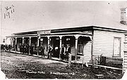
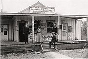
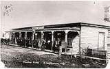
 Within a short space of time the Subritzky family owned or controlled almost all of the North from Awanui northward - the town of Awanui was built by the Subritzky's and their extended family, both Pakeha and Maori. The hub of the Subritzky family operations was the Mount Camel Station and their influence on the Far North for the next fifty years stretched far and wide. They imported cattle and developed their own breed of shorthorn. They developed a shipping link with Auckland, transporting many of the early pioneering families into the northern districts. The Subritzkys also established flax mills and began processing fibres for sales and export. Then came the days of the gum diggers and for the rest of the 1800s and later well into the 1900s it was the gum trade which provided much of the prosperity in Northland.
. On the morning of the 9th the ship encountered a dense fog and the engines were slowed to half speed. The Elingamite was a large inter-colonial passenger steamer and onboard were nearly two hundred souls.
One of the ships look-outs managed to cry out "Breakers ahead!" but it was too late and the ship ploughed on straight ahead and tore herself open on the rocks of West King Island. Within minutes the ship took on a large volume of water. There were six lifeboats on board and they were immediately launched. The captain stayed with his ship until she was fully under and he was washed into the sea and picked up by one of the lifeboats.
Under the command of the Executive Officer L. Berkett, Number Two lifeboat struck out to find help. He took the lifeboat round North Cape
and down the east coast towards Houhora. They landed just north of Mount Camel and several of the party stumbled overland through the scrub to the Houhora Hotel to raise the alarm. The Evans family sent a telegram to Auckland and a rescue fleet was raised. HMS Penguin, SS Omapere, and SS Clansman were despatched from Auckland and took part in the search and rescue, as did the Auxiliary schooner of the Subritzky fleet the Greyhound.
Meanwhile, at Houhora the locals took things into their own hands. They despatched a rider down to Awanui to alert the crew of the Greyhound which was known to be in port. They also knew that a passenger ship, the Zealandia, was sailing up the coast en route to Australia and would soon be passing Mount Camel. Members of the Wagener, Northwood and McIntosh families put to sea in Peter McIntosh's whaleboat and succeeded in getting the Zealandia to hove to. They informed the captain and he immediately got under way at all speed, however leaving behind a very exhausted whaleboat crew to their own devices some 25 miles out to sea.
Note: The whaleboat used by the Houhora families in this rescue now rests in the Auckland War Memorial Museum
.
On the evening of the 10 November 1902, Captain Alfred Subritzky, master of the Greyhound was asleep at his home in Awanui, the Greyhound was tied up alongside the Subritzky wharf. He was awoken by the sound of hoofbeats, a man galloping on a horse calling his name "Captain Subritzky!" The rider drew up outside the house having ridden hard down from Houhora, all the while yelling "The Elingamite's gone down! The Elingamite's gone down!"
"Where's she gone down son?" asked Captain Subritzky.
"She hit the Three Kings, sir," he replied.
After checking his pocket watch Captain Subritzky realised that the tides were all wrong and the bar at the entrance to the harbour at the time was hardly covered by the incoming sea. He hurried down to the Greyhound, roused the crew and made ready for sea wearing sea-boots and pyjamas. They poled down the Awanui river
, then ran up all available canvas - the ship still had to clear the bar.
The Greyhound raced at the bar with the auxiliary engine running and the sails set "Goose Wing" fashion, one boom on the port beam, one boom on the starboard beam and the wind blowing from directly astern. The bow section cleared and then there was a terrific thump as the keel struck the bar, but the vessel shuddered her way over then ploughed northward and into the open sea. The race for the survivors was on.
The Three Kings Islands
are located at the very tip of the North Island and the Greyhound was the first ship to commence the search and uplifted three dead males from the water who were later identified from documents in their clothing as Messer's Green, Parker and C. Johnson. Captain Subritzky wanted to hand the bodies over to the SS Clansman and continue searching further out to sea, however the master of the Clansman refused to take possession of them and so the Greyhound was forced to return to Awanui due to the decaying of the remains. The three deceased were buried in an unmarked grave at Saint Joseph's churchyard in Awanui by the crew of the Greyhound and the Reverend Merton.
of 2 and a roll of 74.
Paparore School is a contributing primary (years 1-6) school slightly north of Awanui, in Waipapakauri. It has a decile rating of 3 and a roll of 117.
Te Rangi Aniwaniwa is a composite school serving years 1-15, with a decile rating of 1 and a roll of 137.
All three schools are coeducational.
Kaitaia
Kaitaia is a town in the far north region of New Zealand, at the base of the Aupouri Peninsula which is about 160 km northwest of Whangarei. It is the last major settlement on the main road north to the capes and bays on the peninsula...
, New Zealand
New Zealand
New Zealand is an island country in the south-western Pacific Ocean comprising two main landmasses and numerous smaller islands. The country is situated some east of Australia across the Tasman Sea, and roughly south of the Pacific island nations of New Caledonia, Fiji, and Tonga...
. It lies at the south of the Aupouri Peninsula
Aupouri Peninsula
The Aupouri Peninsula is a tombolo at the northern tip of the North Island of New Zealand. It projects between the Tasman Sea to the west and the Pacific Ocean to the east...
of the Northland Region. The Awanui River
Awanui River
The Awanui River is a river in the far north of New Zealand. It is located in Northland, close to the point at which the Aupouri Peninsula joins the rest of the North Auckland Peninsula. The Awanui flows first west and then north, for a total of , before flowing into Rangaunu Harbour. The town of...
flows north to Rangaunu Bay. In the 1920s, kauri timber and gum from Kaitaia moved to the coast through Awanui.
State Highway 1
State Highway 1 (New Zealand)
State Highway 1 is the longest and most significant road in the New Zealand roading network, running the length of both main islands. It appears on road maps as SH 1 and on road signs as a white number 1 on a red shield, but it has the official designations SH 1N in the North Island, SH 1S in the...
and 10 intersect at Awanui. Waiharara
Waiharara
Waiharara is a community at the base of the Aupouri Peninsula in Northland, New Zealand. State Highway 1 runs through the community. To the west is Aupouri Forest, and beyond that Ninety Mile Beach. To the east is Rangaunu Harbour. Houhora is 22 km north west, and Awanui is 16 km south east...
is 16 km to the north west, Kaingaroa
Kaingaroa, Northland
Kaingaroa is a locality in Northland, New Zealand. It lies on Highway 10 north east of Awanui and south west of Doubtless Bay.-Education:Kaingaroa School is a coeducational full primary school with a decile rating of 3 and a roll of 159. The school realised in December 2007 that it was becoming...
is about 6 km to the north east, and Kaitaia
Kaitaia
Kaitaia is a town in the far north region of New Zealand, at the base of the Aupouri Peninsula which is about 160 km northwest of Whangarei. It is the last major settlement on the main road north to the capes and bays on the peninsula...
is 8 km to the south.
The population was 351 in the 2006 Census, a decrease of 18 from 2001.
Subritzky family
Early in 1868, John Anton Subritzky and his family sold up the business interests of the Subritzkys in Maldon, Australia and sailed to New Zealand aboard the barquentine Prince Alfred, arriving first in the Port of Auckland and then sailing aboard a family schooner to Houhora and the Mount Camel Station which was a very large estate owned by his older brothers Captain Ludolph Johann and Heinrich Wilhelm.Elingamite tragedy
On the 5 November 1902, the steamer Elingamite had sailed from Sydney bound for AucklandAuckland
The Auckland metropolitan area , in the North Island of New Zealand, is the largest and most populous urban area in the country with residents, percent of the country's population. Auckland also has the largest Polynesian population of any city in the world...
. On the morning of the 9th the ship encountered a dense fog and the engines were slowed to half speed. The Elingamite was a large inter-colonial passenger steamer and onboard were nearly two hundred souls.
One of the ships look-outs managed to cry out "Breakers ahead!" but it was too late and the ship ploughed on straight ahead and tore herself open on the rocks of West King Island. Within minutes the ship took on a large volume of water. There were six lifeboats on board and they were immediately launched. The captain stayed with his ship until she was fully under and he was washed into the sea and picked up by one of the lifeboats.
Under the command of the Executive Officer L. Berkett, Number Two lifeboat struck out to find help. He took the lifeboat round North Cape
North Cape, New Zealand
North Cape is located at the northern end of the North Auckland Peninsula in the North Island of New Zealand . It is the northeastern tip of the Aupouri Peninsula and lies 30 km east of Cape Reinga. The name is sometimes used to refer just to the cape which is known in Māori as Otou and which...
and down the east coast towards Houhora. They landed just north of Mount Camel and several of the party stumbled overland through the scrub to the Houhora Hotel to raise the alarm. The Evans family sent a telegram to Auckland and a rescue fleet was raised. HMS Penguin, SS Omapere, and SS Clansman were despatched from Auckland and took part in the search and rescue, as did the Auxiliary schooner of the Subritzky fleet the Greyhound.
Meanwhile, at Houhora the locals took things into their own hands. They despatched a rider down to Awanui to alert the crew of the Greyhound which was known to be in port. They also knew that a passenger ship, the Zealandia, was sailing up the coast en route to Australia and would soon be passing Mount Camel. Members of the Wagener, Northwood and McIntosh families put to sea in Peter McIntosh's whaleboat and succeeded in getting the Zealandia to hove to. They informed the captain and he immediately got under way at all speed, however leaving behind a very exhausted whaleboat crew to their own devices some 25 miles out to sea.
Note: The whaleboat used by the Houhora families in this rescue now rests in the Auckland War Memorial Museum
Auckland War Memorial Museum
The Auckland War Memorial Museum is one of New Zealand's most important museums and war memorials. Its collections concentrate on New Zealand history , natural history, as well as military history.The museum is also one of the most iconic Auckland buildings, constructed in the neo-classicist...
.
On the evening of the 10 November 1902, Captain Alfred Subritzky, master of the Greyhound was asleep at his home in Awanui, the Greyhound was tied up alongside the Subritzky wharf. He was awoken by the sound of hoofbeats, a man galloping on a horse calling his name "Captain Subritzky!" The rider drew up outside the house having ridden hard down from Houhora, all the while yelling "The Elingamite's gone down! The Elingamite's gone down!"
"Where's she gone down son?" asked Captain Subritzky.
"She hit the Three Kings, sir," he replied.
After checking his pocket watch Captain Subritzky realised that the tides were all wrong and the bar at the entrance to the harbour at the time was hardly covered by the incoming sea. He hurried down to the Greyhound, roused the crew and made ready for sea wearing sea-boots and pyjamas. They poled down the Awanui river
Awanui River
The Awanui River is a river in the far north of New Zealand. It is located in Northland, close to the point at which the Aupouri Peninsula joins the rest of the North Auckland Peninsula. The Awanui flows first west and then north, for a total of , before flowing into Rangaunu Harbour. The town of...
, then ran up all available canvas - the ship still had to clear the bar.
The Greyhound raced at the bar with the auxiliary engine running and the sails set "Goose Wing" fashion, one boom on the port beam, one boom on the starboard beam and the wind blowing from directly astern. The bow section cleared and then there was a terrific thump as the keel struck the bar, but the vessel shuddered her way over then ploughed northward and into the open sea. The race for the survivors was on.
The Three Kings Islands
Three Kings Islands
The Three Kings Islands or Manawa Islands are a group of 13 islands about northwest of Cape Reinga, the northernmost point of the North Island of New Zealand, where the South Pacific Ocean and Tasman Sea converge. They measure about 4.86 km² in area...
are located at the very tip of the North Island and the Greyhound was the first ship to commence the search and uplifted three dead males from the water who were later identified from documents in their clothing as Messer's Green, Parker and C. Johnson. Captain Subritzky wanted to hand the bodies over to the SS Clansman and continue searching further out to sea, however the master of the Clansman refused to take possession of them and so the Greyhound was forced to return to Awanui due to the decaying of the remains. The three deceased were buried in an unmarked grave at Saint Joseph's churchyard in Awanui by the crew of the Greyhound and the Reverend Merton.
Education
Awanui School is a contributing primary (years 1-6) school with a decile ratingSocio-Economic Decile
Decile, Socio-Economic Decile or Socio-Economic Decile Band is a widely used measure in education in New Zealand used to target funding and support to more needy schools....
of 2 and a roll of 74.
Paparore School is a contributing primary (years 1-6) school slightly north of Awanui, in Waipapakauri. It has a decile rating of 3 and a roll of 117.
Te Rangi Aniwaniwa is a composite school serving years 1-15, with a decile rating of 1 and a roll of 137.
All three schools are coeducational.