
Otahuhu
Encyclopedia
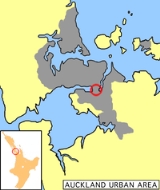
Otahuhu is a suburb
of Auckland
. It is located 13 kilometres (8.1 mi) to the southeast of the city centre, on a narrow isthmus
between an arm of the Manukau Harbour
to the west and the Tamaki River
estuary to the east. The isthmus is the narrowest connection between the North Auckland Peninsula
and the rest of the North Island
, being only some 1200 metres wide at its narrowest point, between the Otahuhu Creek and the Mangere Inlet
. As the southernmost suburb of the former Auckland City
it is considered part of South Auckland
.
The suburb's name is taken from the Māori
name of a volcanic cone now known as Mount Richmond. The name derives from that of a Māori chief, Tahuhu, and means "Of Tahuhu".
Despite its spelling locals typically do not pronounce the second "hu", it is usually referred to as simply "Otahu" (although it would never be written this way).
settlement, where soldiers where given land with the implied understanding that in wartime, they would be raised as units to defend it (however, the eventual fighting a decade later used professional soldiers instead). Most early features from this time have disappeared however, such as a stone bridge built by the fencibles that had to make way to a widening of Great South Road
.
Otahuhu was home to the country's first supermarket, and is also home to the Counties Manukau Police Headquarters, and Otahuhu College
, to which several famous personalities went to including heavyweight boxing champion David Tua
, former prime minister David Lange
, and ex-Manukau
City Mayor, Sir Barry Curtis
.
. The bus interchange, which was badly neglected, is to receive increased attention from early 2011 on, with Maori Wardens present, and increased vandalism/graffiti prevention measures.
The importance for transportation extended to pre-European times. The aptly named Portage Road
runs across the isthmus in Otahuhu and was used by Māori to move their wakas (canoes)
between the Manukau and Waitemata harbours for raids and trading. In fact, the area, also known as Te Tō Waka, was considered the most important portage of all of New Zealand.
Suburb
The word suburb mostly refers to a residential area, either existing as part of a city or as a separate residential community within commuting distance of a city . Some suburbs have a degree of administrative autonomy, and most have lower population density than inner city neighborhoods...
of Auckland
Auckland
The Auckland metropolitan area , in the North Island of New Zealand, is the largest and most populous urban area in the country with residents, percent of the country's population. Auckland also has the largest Polynesian population of any city in the world...
. It is located 13 kilometres (8.1 mi) to the southeast of the city centre, on a narrow isthmus
Isthmus
An isthmus is a narrow strip of land connecting two larger land areas usually with waterforms on either side.Canals are often built through isthmuses where they may be particularly advantageous to create a shortcut for marine transportation...
between an arm of the Manukau Harbour
Manukau Harbour
Manukau Harbour is the second largest natural harbour in New Zealand by area. It is located to the southwest of the Auckland isthmus, and is an arm of the Tasman Sea.-Geography:...
to the west and the Tamaki River
Tamaki River
The Tamaki River is, despite its name, mostly an estuarial arm and harbour of the Hauraki Gulf, within the city of Auckland in New Zealand. It extends south for 15 kilometres from its mouth between the Auckland suburb of Saint Heliers and the long thin peninsula of Bucklands Beach, which reaches...
estuary to the east. The isthmus is the narrowest connection between the North Auckland Peninsula
North Auckland Peninsula
The North Auckland Peninsula, frequently referred to simply as the Northland Peninsula, is located in the far north of the North Island of New Zealand. The peninsula is easily confused with, though not the same as Northland Region, which occupies the top 80% of the peninsula...
and the rest of the North Island
North Island
The North Island is one of the two main islands of New Zealand, separated from the much less populous South Island by Cook Strait. The island is in area, making it the world's 14th-largest island...
, being only some 1200 metres wide at its narrowest point, between the Otahuhu Creek and the Mangere Inlet
Mangere Inlet
Mangere Inlet is an arm of the Manukau Harbour, the southwestern of the two harbours of Auckland, New Zealand and itself an arm of the Tasman Sea. The inlet lies between the two cities of Auckland City and Manukau City and has a size of 6.6 km2 and a catchment of 34.5 km2, being considered to...
. As the southernmost suburb of the former Auckland City
Auckland City
Auckland City was the city and local authority covering the Auckland isthmus and most of the islands of the Hauraki Gulf, in the North Island of New Zealand. On 1 November 2010 it was amalgamated into the wider Auckland Region under the authority of the new Auckland Council...
it is considered part of South Auckland
South Auckland
South Auckland is an imprecisely defined area of Auckland, New Zealand, often stereotyped as a socio-economically disadvantaged, and sometimes rough, urban area with a relatively large Polynesian and Māori population. The name South Auckland is not an official place name but is in common use by New...
.
The suburb's name is taken from the Māori
Maori language
Māori or te reo Māori , commonly te reo , is the language of the indigenous population of New Zealand, the Māori. It has the status of an official language in New Zealand...
name of a volcanic cone now known as Mount Richmond. The name derives from that of a Māori chief, Tahuhu, and means "Of Tahuhu".
Despite its spelling locals typically do not pronounce the second "hu", it is usually referred to as simply "Otahu" (although it would never be written this way).
History
The suburb was established in 1847 as a fencibleFencibles
The Fencibles were army regiments raised in the United Kingdom and in the colonies for defence against the threat of invasion during the American War of Independence and French Revolutionary Wars in the late 18th century...
settlement, where soldiers where given land with the implied understanding that in wartime, they would be raised as units to defend it (however, the eventual fighting a decade later used professional soldiers instead). Most early features from this time have disappeared however, such as a stone bridge built by the fencibles that had to make way to a widening of Great South Road
Great South Road, New Zealand
The Great South Road was the northern section of the earliest highway between Auckland and Wellington, in the North Island of New Zealand. Construction of the Great South Road began in 1861 during the New Zealand Wars...
.
Otahuhu was home to the country's first supermarket, and is also home to the Counties Manukau Police Headquarters, and Otahuhu College
Otahuhu College
Otahuhu College is a secondary school in Auckland, New Zealand for students years 9 to 13.-Location:It is located in the suburb of Otahuhu and is a co-educational school. The school is built in a gully on the southern side of Mangere Road...
, to which several famous personalities went to including heavyweight boxing champion David Tua
David Tua
David "Tuamanator" Tua is a New Zealand professional heavyweight boxer, fighting out of South Auckland, Auckland, New Zealand.He is a former WBO Asia Pacific and WBO Oriental Heavyweight champion....
, former prime minister David Lange
David Lange
David Russell Lange, ONZ, CH , served as the 32nd Prime Minister of New Zealand from 1984 to 1989. He headed New Zealand's fourth Labour Government, one of the most reforming administrations in his country's history, but one which did not always conform to traditional expectations of a...
, and ex-Manukau
Manukau
Manukau City was a large territorial authority in Auckland, New Zealand. The city was sometimes referred to as South Auckland, but this term did not possess official recognition and did not encompass areas like East Auckland, which was previously within the official boundaries of Manukau City...
City Mayor, Sir Barry Curtis
Barry Curtis
Sir Barry Curtis was the Mayor of Manukau from 1983 until 2007. When he announced his intention to retire in 2007, he was New Zealand's longest serving mayor at that time.-Career:...
.
Transport
Otahuhu, in its position on a narrow section of the Auckland Isthmus, is an important part of Auckland's southern transportation approaches for both road and rail, containing a major bus interchange and Otahuhu Train StationOtahuhu Train Station
Otahuhu Train Station is located on the Eastern and Southern Lines of the Auckland Railway Network. It has an island platform layout and can be reached by pedestrian overbridges from Walmsey Road Road and Titi Street...
. The bus interchange, which was badly neglected, is to receive increased attention from early 2011 on, with Maori Wardens present, and increased vandalism/graffiti prevention measures.
The importance for transportation extended to pre-European times. The aptly named Portage Road
Portage Road
Portage Road is an otherwise unremarkable road in the Auckland, New Zealand suburb of Otahuhu. What makes this road special is described in a plaque that is embedded in a concrete plinth at the intersection of Portage Road and Great South Road....
runs across the isthmus in Otahuhu and was used by Māori to move their wakas (canoes)
Waka (canoe)
Waka are Māori watercraft, usually canoes ranging in size from small, unornamented canoes used for fishing and river travel, to large decorated war canoes up to long...
between the Manukau and Waitemata harbours for raids and trading. In fact, the area, also known as Te Tō Waka, was considered the most important portage of all of New Zealand.