

Te Aroha
Encyclopedia
New Zealand
New Zealand is an island country in the south-western Pacific Ocean comprising two main landmasses and numerous smaller islands. The country is situated some east of Australia across the Tasman Sea, and roughly south of the Pacific island nations of New Caledonia, Fiji, and Tonga...
with a population of 3,768 (2006 census). It is 53 km northeast of Hamilton
Hamilton, New Zealand
Hamilton is the centre of New Zealand's fourth largest urban area, and Hamilton City is the country's fourth largest territorial authority. Hamilton is in the Waikato Region of the North Island, approximately south of Auckland...
and 50 km south of Thames
Thames, New Zealand
Thames is a town at the southwestern end of the Coromandel Peninsula in New Zealand's North Island. It is located on the Firth of Thames close to the mouth of the Waihou River. The town is the seat of the Thames-Coromandel District Council....
. It sits at the foot of 952-metre Mount Te Aroha, the highest point in the Kaimai Range.
History
The name Te Aroha comes from the MāoriMāori
The Māori are the native or indigenous Polynesian people of New Zealand . They arrived in New Zealand from eastern Polynesia in several waves at some time before 1300 CE. Over several centuries in isolation, the Māori developed a unique culture with their own language, a rich mythology,...
name of Mount Te Aroha. In one version, Rāhiri, the mythical ancestor of Ngāti Rāhiri Tumutumu
Ngati Rahiri Tumutumu
Ngāti Rāhiri Tumutumu is a Māori iwi of New Zealand. They live at Te Aroha in the Hauraki district.-External links:*...
, climbed the mountain and saw his homeland in the distance and felt a sense of love (aroha) for it. The name is often rendered in English as "place of love".
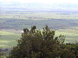
Geography
The Waihou RiverWaihou River
thumb|The Waihou River near [[Putaruru]]The Waihou River is located in the northern North Island of New Zealand. Its former name, Thames River, was bestowed by Captain James Cook....
runs through Te Aroha. Close by to the east is the base of the Kaimai Range, and the town is overlooked by the 952-metre Mount Te Aroha. To the north of the town is the low-lying, swampy land of the Hauraki Plains
Hauraki Plains
The Hauraki Plains are a geographical feature and non-administrative area located in the northern North Island of New Zealand, at the lower end of the Thames Valley...
.
In the late 19th century, Te Aroha was famed as a spa town. Thermal
Hot spring
A hot spring is a spring that is produced by the emergence of geothermally heated groundwater from the Earth's crust. There are geothermal hot springs in many locations all over the crust of the earth.-Definitions:...
and mineral spring
Mineral spring
Mineral springs are naturally occurring springs that produce water containing minerals, or other dissolved substances, that alter its taste or give it a purported therapeutic value...
s are both found close to the centre of the town, as is the world's only hot soda water geyser
Geyser
A geyser is a spring characterized by intermittent discharge of water ejected turbulently and accompanied by a vapour phase . The word geyser comes from Geysir, the name of an erupting spring at Haukadalur, Iceland; that name, in turn, comes from the Icelandic verb geysa, "to gush", the verb...
called the Mokena Hou Geyser.
Economy
Te Aroha is at the centre of a dairy farmingDairy farming
Dairy farming is a class of agricultural, or an animal husbandry, enterprise, for long-term production of milk, usually from dairy cows but also from goats and sheep, which may be either processed on-site or transported to a dairy factory for processing and eventual retail sale.Most dairy farms...
community and much of its economic activity is in serving that community. Tourism is increasing in Te Aroha. The mineral baths are a very popular spot for tourists and locals alike.
Historically mining played a role in the area, and has left some legacies – not all of them positive, such as toxic residues leaking from the abandoned Tui mine
Tui mine
The Tui mine is an abandoned mine on the western slopes of Mount Te Aroha in the Kaimai Range of New Zealand. It is considered to be the most contaminated site in the country, following the clean up of the former Fruitgrowers Chemical Company site at Mapua, Nelson.-History:In the 1960s, the Tui...
tailings dam.
Events
- Waihou and Te Aroha Cobras play an annual rugby match for the Dr Dunn memorial trophy. This is one of the biggest days on the calendar of Te Aroha.
- A Day in the Domain was started in Te Aroha in 1977 by the Arts Council and continues to be a fun, affordable day out. The day attracts artists and performers from far and wide with a variety of stalls and foodies on display. Entertainment is free with competitions and games all day.
- The King and Queen of the Mountain and Bald Spur Derby have been annual events in Te Aroha since the 1950s. Held the weekend before Christmas, the challenge is to be the first man or woman up Mt Te Aroha and back down again. This has been achieved in under one hour. The Bald Spur Derby offers competitors a shorter but still challenging course.
- Te Aroha AP & H Show has been running since the 1890s. Boasting one of the most extensive home industries sections, it has full agricultural and equestrian sections and the usual country fair activities such as the gumboot throwing competition and cattle dogs.
Notable people
- Olympic Gold Medalist Peter SnellPeter SnellSir Peter George Snell, KNZM, MBE is a former New Zealand athlete, now resident in Texas, United States. He had one of the shortest careers of world famous international sportsmen, yet achieved so much that he was voted New Zealand’s "Sports Champion of the Century"...
- All Blacks Don ClarkeDon ClarkeDonald Barry Clarke was a New Zealand rugby union player who played 89 times as a New Zealand international from 1956 until 1964...
, Carl HoeftCarl HoeftCarl Hoeft is a New Zealand rugby union footballer. He currently plays for French club Stade Toulousain after signing from Castres Olympique in the Summer of 2011. His usual position is at prop. He was a part of the All Blacks squad at the 2003 Rugby World Cup.-External links:* *...
, Keith Robinson (rugby union) and Kevin O'Neill (rugby union) - Ian S. ArdernIan S. ArdernIan Sidney Ardern has been a member of the First Quorum of the Seventy of The Church of Jesus Christ of Latter-day Saints since 2011...
of the First Quorum of the Seventy of The Church of Jesus Christ of Latter-day Saints was born in the town.