
Megalong Valley
Encyclopedia
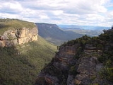
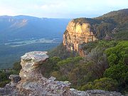
The Megalong Valley is part of the Blue Mountains of New South Wales
, Australia
. It is located west of Katoomba. On its eastern side, the valley is separated from the Jamison Valley
by Narrow Neck Plateau. The Shipley Plateau
overlooks part of the valley.
 The name Megalong Valley is derived from an Aboriginal word thought to mean 'Valley Under The Rock'. The first record of a European coming to the valley was of Thomas Jones, a natural history specimen collector, who followed the course of Coxs River from Burragorang to Hartley, New South Wales
in 1818. The first land was taken up in 1838, by settlers who travelled from Burragorang and Camden, New South Wales
. Later in the 19th century, a shale mine was operated by one J.B.North. He named a nearby glen after his daughter Nellie and it is still known as Nellies Glen today. The shale mine eventually went the way of all shale mines because they were not viable in the long run.
Today the valley is still used for farming, but tourism has increased since the historic Six Foot Track
was restored. This track was marked out in the 19th century as a bridle trail from Katoomba to Jenolan Caves
. It was called the Six Foot Track because it had to be that wide in order to accommodate two to three riders riding abreast. It fell into disuse eventually but was restored more recently as a walking trail by the Department of Lands. It begins at the Explorers Tree at Katoomba, goes down through Nellies Glen and across the Megalong Valley to Coxs River. On the other side of the river, the trail crosses some ranges before reaching Jenolan Caves Road. It then heads south to finish at Jenolan.
New South Wales
New South Wales is a state of :Australia, located in the east of the country. It is bordered by Queensland, Victoria and South Australia to the north, south and west respectively. To the east, the state is bordered by the Tasman Sea, which forms part of the Pacific Ocean. New South Wales...
, Australia
Australia
Australia , officially the Commonwealth of Australia, is a country in the Southern Hemisphere comprising the mainland of the Australian continent, the island of Tasmania, and numerous smaller islands in the Indian and Pacific Oceans. It is the world's sixth-largest country by total area...
. It is located west of Katoomba. On its eastern side, the valley is separated from the Jamison Valley
Jamison Valley
The Jamison Valley forms part of the Coxs River canyon system in the Blue Mountains of New South Wales, Australia. It is situated approximately 100 kilometres west of Sydney, capital of New South Wales, and a few kilometres south of Katoomba, the main town in the Blue Mountains.-History:The...
by Narrow Neck Plateau. The Shipley Plateau
Shipley Plateau
Shipley Plateau is located south of Blackheath, New South Wales in the Blue Mountains of New South Wales, Australia. Faced with sandstone escarpments, the plateau is accessible by road and some of the land area is planted with fruit orchards...
overlooks part of the valley.
Description and History
Hartley, New South Wales
Hartley is a historical village in New South Wales, Australia, in the City of Lithgow, located approximately 150 kilometres west of Sydney. It is below the western escarpment of the Blue Mountains....
in 1818. The first land was taken up in 1838, by settlers who travelled from Burragorang and Camden, New South Wales
Camden, New South Wales
-Education:Camden is the location of research facilities for the veterinary and agricultural schools of the University of Sydney. The local government area has two public high schools, Camden High School and Elderslie High School, as well as eight Catholic and three Anglican schools.-Culture:The...
. Later in the 19th century, a shale mine was operated by one J.B.North. He named a nearby glen after his daughter Nellie and it is still known as Nellies Glen today. The shale mine eventually went the way of all shale mines because they were not viable in the long run.
Today the valley is still used for farming, but tourism has increased since the historic Six Foot Track
Six Foot Track
The Six Foot Track was originally a bridle trail from Katoomba to the Jenolan Caves, and is now a walking trail of 44.3 kilometres.- History :...
was restored. This track was marked out in the 19th century as a bridle trail from Katoomba to Jenolan Caves
Jenolan Caves
The Jenolan Caves are caves in the Blue Mountains, New South Wales, Australia; 175 kilometres west of Sydney. They are the most celebrated of several similar groups in the limestone of the country being the oldest discovered open caves in the world...
. It was called the Six Foot Track because it had to be that wide in order to accommodate two to three riders riding abreast. It fell into disuse eventually but was restored more recently as a walking trail by the Department of Lands. It begins at the Explorers Tree at Katoomba, goes down through Nellies Glen and across the Megalong Valley to Coxs River. On the other side of the river, the trail crosses some ranges before reaching Jenolan Caves Road. It then heads south to finish at Jenolan.