
Yarra River
Encyclopedia
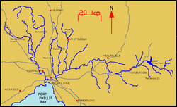
The Yarra River, originally Birrarung, is a river
in east-central Victoria
, Australia
. The lower stretches of the river is where the city of Melbourne was established in 1835 and today Greater Melbourne dominates and influences the landscape of its lower reaches. From its source in the Yarra Ranges, it flows 242 km west through the Yarra Valley
which opens out into plains as it winds its way through Greater Melbourne before emptying into Hobsons Bay
in northernmost Port Phillip
.
The river was a major food source and meeting place for indigenous Australians
from prehistoric times. Shortly after the arrival of European settlers
land clearing forced the remaining Wurundjeri to neighbouring territories and away from the river. Originally called Birrarung by the Wurundjeri
, the current name was mistranslated from another Wurundjeri term; Yarra Yarra.
The river was utilised primarily for agriculture by early European settlers. The landscape of the river has changed dramatically since 1835. The course has been progressively disrupted and the river widened in places. The first of many Crossings of the Yarra River to facilitate transport
was built in Princes Bridge. Beginning with the Victorian gold rush
it was extensively mined, creating the Pound Bend Tunnel
in Warrandyte, and the Big
and Little
Peninsula Tunnels above Warburton
. Widening and dams, like the Upper Yarra Reservoir have helped protect Melbourne from major flooding, The catchment's upper reaches are also affected by logging
. Industrialisation
ultimately led to the destruction of the marshlands at the confluence of the Yarra and Maribyrnong
Rivers in the area around Coode Island
in West Melbourne
.
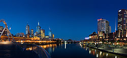
Today, the mouth and including Swanston and Appleton Docks are used for container shipping by the Port of Melbourne
, the busiest on the continent. The city reach which is inaccessible to larger watercraft, has seen increased use for both transport and recreational boating (including kayaking
, canoeing
, rowing
and swimming). In recent years however recreational use of the river is threatened by high levels of pollution in its lower stretches. The upper reaches remain relatively healthy.
The annual Moomba
festival celebrates the Yarra River's increasing cultural significance to Melbourne.
people who occupied the Yarrak Valley and much of Central Victoria prior to European settlement. It is thought that Birrarung is derived from Wurundjeri words meaning "ever flowing". Another common term was Birrarung Marr, thought to mean "river of mist" or "river bank". Upon European arrival it was given the name Yarrak Yarrak by John Helder Wedge
of the Port Phillip Association
in 1835, in the mistaken belief that this was the Aboriginal
name for the river, however it is believed that Yarrak means "waterfall", "flow", or refers to running or falling water, descriptive of any river or creek in the area, not just the Yarrak. The name Yarrak Yarrak is said to mean "ever flowing river". Of their contact with local Wurunderi people in 1835, John Wedge wrote
 The area surrounding the Yarra River and modern day Melbourne
was originally inhabited by various clans of the Wurundjeri
people of the Kulin
nation. It is believed that the area was occupied by indigenous Australians
for at least 30,000 years. The river was an important resource for the Wurundjeri people and several sites along the river and its tributaries were important meeting places where corroborees were held between indigenous communities. The river's resources were utilised sustainably
by the Wurundjeri
until the advent of early European settlement in the early-mid-19th century.
 In 1803, the first Europeans sailed up the river, a surveying party led by Charles Grimes
, Acting Surveyor
General of New South Wales
, sailed upstream to Dights Falls
where they could no longer continue due to the nature of the terrain. European explorers would not enter the river for another 30 years until, in 1835, the area that is now central and northern Melbourne was explored by John Batman
, a leading member of the Port Phillip Association
, who negotiated a transaction for 600,000 acres (2,400 km²) of land from eight Wurundjeri
elders. He selected a site on the northern bank of the Yarra River, declaring that "this will be the place for a village".
The river was instrumental in the establishment of Melbourne
along its banks from 1835 onwards. The new settlement's main port was sited near Queensbridge, the place where saltwater
met freshwater
. Ships would use one side of the falls while the other side provided fresh drinking water for the town and a convenient sewer. In the city's early days the Yarra was one of two major ports, the other being Sandridge or Port Melbourne, but the Yarra was preferred due to the direct access to the town's main streets and was the location of Customs House. Early industries grew along the banks of the river, rapidly degrading the water quality until Melbourne
's fresh water had to be sourced from elsewhere. Industries then began using the river and tributaries such as Merri Creek
as landfill and for harmful chemical dumps for substances like grease and oils.
The first permanent crossing over the river was Princes Bridge
, which first opened as a wooden trestle bridge in 1844, the current bridge was constructed in 1888. In the early days, the river would frequently flood. While this was not considered a problem in the floodplains near Yarra Glen and Coldstream
, however it caused much trouble further downstream in settlements such as Warrandyte, Templestowe, Bulleen, Heidelberg
and Ivanhoe
. The Upper Yarra Dam was later constructed to alleviate the flooding, protecting settlements along the river, yet depriving the river banks of soil and silt deposits and causing other problems such as erosion
and salinity
.
 Gold
Gold
was first discovered in Victoria near the Yarra River in Warrandyte. The find was made by Louis Michel in 1851 at a tributary of the river, Anderson's Creek and marked the start of the Victorian gold rush
. The approximate location of the site is marked by a cairn on Fourth Hill in the Warrandyte State Park
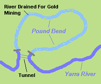
. The river was drained and diverted in various areas throughout the gold rush to aid gold miners. An example of this is the tunnel
at Pound Bend in Warrandyte. The river was partially dammed at Pound Bend near Normans Reserve at its eastern entrance and near Bob's wetlands at its western exit. Miners then blasted a 145m long tunnel through solid rock. The river was then fully dammed at the entrance and exit to the tunnel and water was diverted through 145m and out the other side leaving an 3.85 km of riverbed around Pound Bend exposed to the sun and the miners picks. Other diversion include The Island
cutting in Warrandyte and the Little Peninsula Tunnel
and Big Peninsula Tunnel
near McMahons Creek.
The Gold Rush saw increased development in Melbourne and "tent cities" of new migrants lined the Yarra during the early years of the gold rush. In the 1840s a weir was built at Dights Falls
to power a flour mill and to give some control over the river downstream from there. From the earliest years of settlement, the mid and upper reaches of the Yarra began to be used for recreation. The river was selected as the site for the Royal Botanic Gardens
in 1846 and the course of the river was modified slightly for the creation of a feature lake. Further upstream, the Cremorne Gardens
were established in 1853.
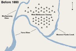
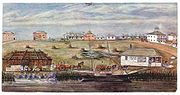
 Sections of the river mouth and the area around the former West Melbourne Swamp were widened in the late 19th century, to make way for docks, harbours, bridges and other infrastructure. The increasing industrialisation of the river and the growth of the shipping industry saw the need for major infrastructure works which dramatically changed the course of the river in its lower reaches. The creation of new shipping channels to cope with the growing use of the Yarra by cargo ships was first tabled in the 1870s.
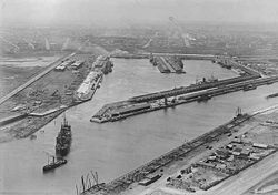
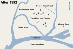
The first major change came with the cutting of the "Fisherman's Bend" channel between 1880 and 1886. This major infrastructure project created an island which was known as Coode Island, named after the engineer in charge of the excavation and dock construction works, Sir John Coode
. This also included widening and deepening, and in some cases, vast areas of land were excavated, such as Victoria Dock
, in order to give ease of access for cargo and container ships. Abbitoirs, smelters and even mortuaries were to use the river as a means of waste disposal in its lower reaches. This industrialisation also led to a steady deterioration in water quality during the 19th century and into the 20th. In 1891, the great flood caused the Yarra to swell to 305 metres (1,000.7 ft) in width.
Initially known as "West Melbourne Dock", over 3 million cuyds (2,293,664.6 m³) of material was excavated and a new dock was eventually opened in 1892, the material that was removed was subsequently used to fill in part of the West Melbourne Swamp, it took 6 days for water from the Yarra River to fill the dock. The dock was later renamed Victoria Dock. In 1910, the main channel was widened and deepened (81 metre). In 1916, the central pier at Victoria Dock was completed which provided 6 additional shipping berths and cargo sheds and creating a distinctive landmark for Melbourne ports. By 1942, 650m of the old course of the Yarra River at Coode Island had been filled in, by the 1950s it had been completely filled and land parcels were allocated including a site for the new Fish Markets.
In 1957, the Upper Yarra Reservoir was constructed, primarily to alleviate flooding downstream. This reduced the river's flow to around 50%, where it sits today. Swanson Dock was constructed between 1966 and 1972 equipped for modern container shipping. Shipping activity at Victoria Dock during this time had gone into steep decline and it was almost disused by the mid 1970s. In February 1972, the CBD was flooded as the natural watercourse of Elizabeth Street became a raging torrent. This was due mostly to previous storm water drainage works which utilised Elizabeth street as a watercourse during times of intense rain creating flash floods. Prior to settlements, the area now occupied by Elizabeth street was a gully
off the river.
 By the 1960s there was a growing awareness of the neglect of the Yarra amongst some residents of Melbourne
, spawning various community groups and "friends of..." organisations to protect the remnants of the river's ecology. Through the 1970s and 80s, many desirable developments alongside the river began, such as the Victorian Arts Centre, as its lower courses progressively became gentrified. Growing high density residential development in the lower reaches in the early 1990s coincided with minor government programs such as the installation of litter traps
. The riverside apartment complex Como Centre at South Yarra
and the larger urban renewal of the formerly industrial Southbank
precinct were both built during the late 90s.
Around 2000, the river through the Melbourne city centre became a focus of major government projects. Projects were proposed to connect Flinders Street Station with the river and early proposals for the Melbourne Museum
were situated along the south side of the river, however the Crown Casino and Entertainment Complex and Melbourne Exhibition and Convention Centre
were built in its place. The Melbourne Docklands
urban renewal project began in 2000, comprising mixed use residential and commercial land and recreational boating moors along the river at the disused Victoria Docks and also on the southside of the Yarra. Federation Square
was proposed to connect the spine of Melbourne to the Yarra at Federation Wharf and a neighbouring park, Birrarung Marr
was also built along the banks. Some suggest this connection between the City and the river could have been made better and many feel that Federation Square was rushed and neglects the river that it sits next to. New ferry services and water taxis sprang up along the city reach, servicing as far up river as South Yarra and out to Hobsons Bay.
In 2008, dredging began to deepen the mouth of the Yarra to facilitate the latest 5th Generation Container Ships. It was subject to controversy and strict regulations among fears that it could disturb heavy metals
and other toxic sediments mostly deposited during the industrial era of Melbourne.
 The Yarra River was an important resource for the Wurundjeri
people for around 40,000 years. The river's resources were utilised sustainably
by the Wurundjeri until European settlement in the early-mid-19th century . Early industry located along the river contributed great amounts of pollution such as dangerous chemicals, grease, oil and heavy metals. Through the mid-20th century, industry was slowly relocated away from the river and since then the major pollutants have come from storm water runoff, sewerage and lasting effects of previous pollution. Gold mining cleared small areas of land of vegetation and for periods of time, drained sections of the river, however when compared to land clearing and industrial pollutants, the effects of gold mining on the river were quite low.
Heavy metals deposited into the river throughout the late 19th century and early 20th century settled to the bottom of the river bed, particularly in the lower reaches through the city and Port Melbourne, and due to the increased artificial depth of the river through here, heavy metals have not been carried further, although some have been deposited out into Port Phillip
. Oils and grease remain today in several tributaries in the lower reaches such as Merri Creek
and Moonee Ponds Creek .
and substances like grease, oils and heavy metals in the Yarra River and its tributaries are a major problem.
High levels of E. coli, some up to 200 times the safe limit in its tributaries, are caused primarily by poorly maintained septic systems.
Up to 350,000 cigarette
butts enter the Yarra catchment storm water runoff every day, these serve as just a small representation of the rubbish and litter that are disposed of in storm water runoff areas that eventually make their way into the river and from river makes its way to sea
Some industrial companies continue to use the Yarra as a dumping ground. For example in recent years paper company Amcor
has been fined several times by EPA Victoria for polluting the Yarra and environs. In 2007 it was fined A$5,000 for discharging paper pulp into the Yarra from its Alphington plant and in 2008 the company was convicted for releasing oil into the Yarra from its Alphington
plant and fined A$80,000.
Several programs are being implemented to minimise beach and river pollution, mostly organised by community groups, EPA Victoria and local councils.
and salinity
, issues that ironically affect surrounding agriculture.
 The Yarra River has a detailed and complex geological history, see "Geology". It was utilised and managed sustainably
by the Wurundjeri
for around 40,000 years, however since the European settlement and use of the river in the mid-19th century, its geography has changed substantially reflecting the unsustainable
use of the river and surrounding resources. The river is fed by a number of small unnamed creeks and streams in the Yarra Ranges as well as 49 named tributaries, most of which are creeks
. The river's lower reaches travel through central Melbourne
. It is approximately 242 kilometres (150.4 mi) in length, with a mean annual flow of 718 GL, which is roughly 50% its original flow prior to damming. It is the most westerly snow fed river in Australia. The total catchment area is approximately 4000 square kilometres (1,544.4 sq mi).
, Moonee Ponds Creek
, Merri Creek
, Darebin Creek
, Plenty River
, Mullum Mullum Creek and Olinda Creek
. The river hosts many geographical features such as; bends, rapid
s, lake
s, island
s, floodplain
s, billabong
s and wetland
s. Most features have been named after translated Wurundjeri
phrases or have European, particularly British
, origins. Some of the river's more prominent features include; Coode Island and Fishermans Bend, Victoria Harbour
, Herring Island
, Yarra Bend, Dights Falls, Upper Yarra Dam and Reservoir and many river flats and billabongs.
and jellyfish
and in the upper reachers smaller quantities of European perch
(redfin), Macquarie Perch
, Brown Trout
, Murray Cod
and Freshwater Catfish
. However almost all of the fish are contaminated with heavy metals including arsenic
and not fit for human consumption. Dolphins have been known to venture upstream as far as South Yarra, and serve as an example of the increased salinity of the river's lower reaches.
s in the upper reaches of the Yarra Ranges National Park
, directly to the west of the Mount Baw Baw
plateau, a thickly forested subalpine park, which is entirely closed-off to all except the employees of Melbourne Water
. The park features extensive stands of mountain ash
, a very tall eucalypt
, tree ferns, as well as patches of remnant rainforest.
The Upper Yarra Dam
, one of a number of dams in the Yarra Catchment that supply a large part of Melbourne
's water, is the furthest upstream point on the river visible to the general public (though the dam itself is closed off). The first settlement the still-young river passes through is the small town of Reefton, but most of the river is surrounded by hills covered temperate forest until the timber and resort town of Warburton
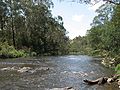
. The Woods Point Rd follows the river through this section.
 Downstream of Warburton, the Yarra Valley gradually opens out and farms begin to appear, including beef and dairy farms, and by the town of Woori Yallock
and the river's turn north, increasingly large areas are covered by vineyards, forming the Yarra Valley
wine region. At Healesville
, the river turns west again and the stream bed becomes increasingly silty, reducing the clarity of the water, and by the commuter town of Yarra Glen
it begins to take on the brownish colour that the lower reaches are known for.
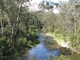
 The river enters Melbourne's suburbs proper at Chirnside Park, but virtually all the river's length is surrounded by parkland, much retaining (or having been replanted with) extensive native vegetation. A bicycle
and walking trail known as the Main Yarra Trail begins at Warrandyte
and becomes the Yarra River Trail, and in the lower reaches, the Capital City Trail
. The river is used extensively for kayaking at Templestowe
, and canoes can often be seen throughout the suburban section. Whilst the water is not particularly clear, its quality is sufficient for edible fish to swim within it. Some small hobby farms are located in the floodplain area of the river, surprisingly close to central Melbourne and almost completely surrounded by suburbs.
Heidelberg formed the home of the Heidelberg School
, widely considered the first European painters to accurately capture the Australian landscape and its distinctive features. The walking trail features placards displaying some of their paintings at the settings they were actually painted; some features depicted remain clearly recognisable today.

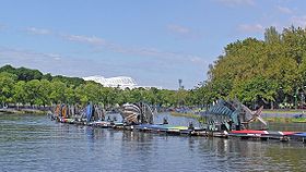
 Below Dights Falls
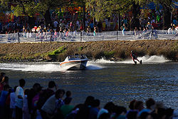
at Yarra Bend Park in inner Melbourne, the river becomes increasingly estuarine as it passes along the southern side of the central business district. This area forms the venue for the annual "Moomba
" festival, which notably features an annual water skiing
competition which attracts a huge crowd. The lower stretch of the river from Docklands to the Melbourne Cricket Ground
was part of the final path of the Queen's Baton Relay
of the 2006 Commonwealth Games
. Many of Melbourne's private schools, located close to the river, train their rowing
crews on it.
The lower reaches feature a number of boat cruises, using especially low-roof boats to go under the many bridges across this section of the Yarra. Herring Island
is a small island at South Yarra which has a punt which takes people on to the park. The area in front of old Customs House is a former turning basin for ships. It is the point which was once known as "Freshwater Place" and once had a set of cascades which prevented both salt water and larger ships from going further upstream. This series of rocks, originally used to cross the river, and referred to as the "Yarra Falls" was removed using explosives and divers in 1883.
The final section passes through the Port of Melbourne
and under the Bolte Bridge
and the West Gate Bridge
. The current course dates back to 1886 when a canal devised by British engineer Sir John Coode
was cut from west of Flinders Street to below its junction with the Maribyrnong. The resulting island between the new and old courses of the river was named Coode Island, and is now part of the mainland with the former course to the north filled in. The river flows into Port Phillip
, the site being extensively altered as part of the Port of Melbourne, Australia's busiest seaport.
 Since the first permanent crossing was built over the river in 1844, there are now over 60 places where pedestrians, cars and other vehicles can cross the river. As the river is never wider than around 350m and is on average only around 50m wide, most of the crossings are located in the suburbs of Greater Melbourne. While there are fewer crossings towards the mouth of the river, most notably the West Gate
, Bolte
and Princes Bridges, and the Burnley
and Domain
Tunnels. Small historical bridges can be found further downstream including the Banksia Street, Fitzsimons Lane and Warrandyte Bridges. Beyond Warburton
there are very few crossings available. Some of the more prominent and historical crossings include;

Several reserves have been set aside adjoining the Yarra, mostly to preserve the natural environment or for recreation, many of these are managed and operated by Parks Victoria
, the state government agency responsible for the management of Victoria's national parks and other reserves. The largest and most notable of these parklands include: the Royal Botanic Gardens
, Birrarung Marr, Yarra Bend Park, Westerfolds Park, Warrandyte State Park
and the Yarra Ranges National Park
.
s adjoining the river, these include, from downstream to upstream:
 The Yarra is considered and important part of Melbourne's culture and a symbol of the city, and as a result, it has been the source of artistic and cultural expression.
 Throughout its length, the waters of the Yarra River and its banks are used for; boating
, rowing
, water skiing
, kayaking
, canoeing
, swimming, fishing
, cycling
, running
and walking
, amongst other things. In the rivers upper reaches, fishing
is most popular. Upstream of Launching Place
the river becomes quite narrow and recreational use is limited. In the middle reaches, canoeing
and kayaking
is popular, there are a few rapids of easy to medium difficulty depending on the water level.
Swimming is also popular in the middle reaches throughout summer, particularly around Warrandyte, however, it should be noted that around this area there are submerged mining shafts which can cause undertows that suck swimmers under the surface and into these shafts. In the period 2004–08, 3 people died in this manner in Warrandyte alone. Swimming is safer downstream, but not advisable below Dights Falls
due to the high levels of pollution.
In the lower reaches, the river is mostly used for rowing
, there are several rowing sheds along the city stretch east of the Princes Bridge and many private schools have rowing clubs with sheds and berths on the river. At certain times of the year, particularly during the Moomba Festival, this stretch of the river is occupied by water skiing
courses and jumps. The banks of the Yarra River are popular for cycling
, running
and walking
where most paths are sealed and in good condition. Two major off-road, sealed trails, the Yarra River Trail and Capital City Trail
follow the river on its course through the city, while part of the Bayside Trail also connects with the river.
The river is also popular for boating
, in the residential suburb of Toorak
some of the larger mansions have private boat moorings, whilst newer developments in Melbourne Docklands have larger marinas as does Pier 31 at Fisherman's Bend and Newport and Williamstown at the river's mouth. Boating is difficult beyond Hawthorn
and impossible past Dights Falls
. It is mostly concentrated in central Melbourne where cruises go up and down the river and ferries operate.
and the Port of Melbourne Corporation
who administer the area downstream of Bolte Bridge. There is a maximum speed limit of 9 kilometres per hour (5 knots) for all boats operating on the river. Sections of the river are occasionally closed for public events such as Moomba
, New Year's Eve and Rowing events.
The river is navigable by most boats from its entrance in Hobsons Bay to Dights Falls (a stretch of 22 km) and is subject to tidal variations and submerged objects. There are four bridges on the Yarra River with limited height clearances at high tide:
River
A river is a natural watercourse, usually freshwater, flowing towards an ocean, a lake, a sea, or another river. In a few cases, a river simply flows into the ground or dries up completely before reaching another body of water. Small rivers may also be called by several other names, including...
in east-central Victoria
Victoria (Australia)
Victoria is the second most populous state in Australia. Geographically the smallest mainland state, Victoria is bordered by New South Wales, South Australia, and Tasmania on Boundary Islet to the north, west and south respectively....
, Australia
Australia
Australia , officially the Commonwealth of Australia, is a country in the Southern Hemisphere comprising the mainland of the Australian continent, the island of Tasmania, and numerous smaller islands in the Indian and Pacific Oceans. It is the world's sixth-largest country by total area...
. The lower stretches of the river is where the city of Melbourne was established in 1835 and today Greater Melbourne dominates and influences the landscape of its lower reaches. From its source in the Yarra Ranges, it flows 242 km west through the Yarra Valley
Yarra Valley
The Yarra Valley is the name given to the region surrounding the Yarra River in Victoria, Australia. The river originates approximately 90 kilometres east of the City of Melbourne and flows towards it and out into Port Phillip Bay...
which opens out into plains as it winds its way through Greater Melbourne before emptying into Hobsons Bay
Hobsons Bay
Hobsons Bay is a bay in Port Phillip, Victoria, Australia....
in northernmost Port Phillip
Port Phillip
Port Phillip Port Phillip Port Phillip (also commonly referred to as Port Phillip Bay or (locally) just The Bay, is a large bay in southern Victoria, Australia; it is the location of Melbourne. Geographically, the bay covers and the shore stretches roughly . Although it is extremely shallow for...
.
The river was a major food source and meeting place for indigenous Australians
Indigenous Australians
Indigenous Australians are the original inhabitants of the Australian continent and nearby islands. The Aboriginal Indigenous Australians migrated from the Indian continent around 75,000 to 100,000 years ago....
from prehistoric times. Shortly after the arrival of European settlers
Foundation of Melbourne
The city of Melbourne was founded in 1835. The exact circumstances of the foundation of Melbourne, and the question of who should take credit, have long been matters of dispute.-Exploration:...
land clearing forced the remaining Wurundjeri to neighbouring territories and away from the river. Originally called Birrarung by the Wurundjeri
Wurundjeri
The Wurundjeri are a people of the Indigenous Australian nation of the Woiwurrung language group, in the Kulin alliance, who occupy the Birrarung Valley, its tributaries and the present location of Melbourne, Australia...
, the current name was mistranslated from another Wurundjeri term; Yarra Yarra.
The river was utilised primarily for agriculture by early European settlers. The landscape of the river has changed dramatically since 1835. The course has been progressively disrupted and the river widened in places. The first of many Crossings of the Yarra River to facilitate transport
Transport
Transport or transportation is the movement of people, cattle, animals and goods from one location to another. Modes of transport include air, rail, road, water, cable, pipeline, and space. The field can be divided into infrastructure, vehicles, and operations...
was built in Princes Bridge. Beginning with the Victorian gold rush
Victorian gold rush
The Victorian gold rush was a period in the history of Victoria, Australia approximately between 1851 and the late 1860s. In 10 years the Australian population nearly tripled.- Overview :During this era Victoria dominated the world's gold output...
it was extensively mined, creating the Pound Bend Tunnel
Pound Bend Tunnel
The Pound Bend Tunnel, or the Evelyn Tunnel, is a diversion tunnel on the Yarra River at Warrandyte, Victoria, Australia, approximately 24 km north-east of Melbourne...
in Warrandyte, and the Big
Big Peninsula Tunnel
The Big Peninsula Tunnel is a small river diversion tunnel on the upper Yarra River near McMahons Creek, around 80 km East of Melbourne, Victoria, Australia. The tunnel was dug in 1864, during the Victorian gold rush, by alluvial gold miners to provide access to the bed of the Yarra River...
and Little
Little Peninsula Tunnel
The Little Peninsula Tunnel is a small river diversion tunnel on the upper Yarra River near McMahons Creek, around 80 km East of Melbourne, Victoria, Australia...
Peninsula Tunnels above Warburton
Warburton, Victoria
Warburton is a town in Victoria, Australia, 72 km east from Melbourne's central business district. Its Local Government Area is the Shire of Yarra Ranges. At the 2006 Census, Warburton had a population of 2288....
. Widening and dams, like the Upper Yarra Reservoir have helped protect Melbourne from major flooding, The catchment's upper reaches are also affected by logging
Logging
Logging is the cutting, skidding, on-site processing, and loading of trees or logs onto trucks.In forestry, the term logging is sometimes used in a narrow sense concerning the logistics of moving wood from the stump to somewhere outside the forest, usually a sawmill or a lumber yard...
. Industrialisation
Industrialisation
Industrialization is the process of social and economic change that transforms a human group from an agrarian society into an industrial one...
ultimately led to the destruction of the marshlands at the confluence of the Yarra and Maribyrnong
Maribyrnong river
The Maribyrnong River rises about 50 km north of Melbourne, Victoria , near Mount Macedon. It flows generally southward and combines with the Yarra River to flow into Port Phillip....
Rivers in the area around Coode Island
Coode Island
Coode Island, was an island at the convergence of the Yarra and Maribyrnong Rivers, 4km west of central Melbourne, Australia. Today the low-lying land is part of the Port of Melbourne, site of Swanson and Appleton Docks and their associated container storage and rail yards, as well as a number of...
in West Melbourne
West Melbourne, Victoria
West Melbourne is an inner city suburb of Melbourne, Victoria, Australia, 3 km north-west from Melbourne's central business district. Its Local Government Area is the City of Melbourne...
.
Today, the mouth and including Swanston and Appleton Docks are used for container shipping by the Port of Melbourne
Port of Melbourne
The Port of Melbourne is Australia's busiest port for containerised and general cargo. It is located in Melbourne, Victoria and covers an area at the mouth of the Yarra River, downstream of Bolte Bridge, which is at the head of Port Phillip, as well as several piers on the bay itself...
, the busiest on the continent. The city reach which is inaccessible to larger watercraft, has seen increased use for both transport and recreational boating (including kayaking
Kayaking
Kayaking is the use of a kayak for moving across water. Kayaking and canoeing are also known as paddling. Kayaking is distinguished from canoeing by the sitting position of the paddler and the number of blades on the paddle...
, canoeing
Canoeing
Canoeing is an outdoor activity that involves a special kind of canoe.Open canoes may be 'poled' , sailed, 'lined and tracked' or even 'gunnel-bobbed'....
, rowing
Rowing (sport)
Rowing is a sport in which athletes race against each other on rivers, on lakes or on the ocean, depending upon the type of race and the discipline. The boats are propelled by the reaction forces on the oar blades as they are pushed against the water...
and swimming). In recent years however recreational use of the river is threatened by high levels of pollution in its lower stretches. The upper reaches remain relatively healthy.
The annual Moomba
Moomba
Moomba is Australia's largest free community festival and one of the longest running festivals in Australia. Held annually in the city of Melbourne, Australia, Moomba is celebrated during the Labour Day long weekend , and has been celebrated since 1955...
festival celebrates the Yarra River's increasing cultural significance to Melbourne.
Etymology
The river was called Birrarung by the WurundjeriWurundjeri
The Wurundjeri are a people of the Indigenous Australian nation of the Woiwurrung language group, in the Kulin alliance, who occupy the Birrarung Valley, its tributaries and the present location of Melbourne, Australia...
people who occupied the Yarrak Valley and much of Central Victoria prior to European settlement. It is thought that Birrarung is derived from Wurundjeri words meaning "ever flowing". Another common term was Birrarung Marr, thought to mean "river of mist" or "river bank". Upon European arrival it was given the name Yarrak Yarrak by John Helder Wedge
John Helder Wedge
John Helder Wedge was a surveyor, explorer and politician in Van Diemen's Land .Wedge was the second son of Charles Wedge of Shudy Camps, Cambridge, England. John Wedge learned the basics of surveying from his father...
of the Port Phillip Association
Port Phillip Association
The Port Phillip Association was formally formed in June 1835 to settle land in what would become Melbourne, which the association believed had been acquired by John Batman for the association from Wurundjeri elders after he had obtained their marks to a document, which came to be known as...
in 1835, in the mistaken belief that this was the Aboriginal
Indigenous Australians
Indigenous Australians are the original inhabitants of the Australian continent and nearby islands. The Aboriginal Indigenous Australians migrated from the Indian continent around 75,000 to 100,000 years ago....
name for the river, however it is believed that Yarrak means "waterfall", "flow", or refers to running or falling water, descriptive of any river or creek in the area, not just the Yarrak. The name Yarrak Yarrak is said to mean "ever flowing river". Of their contact with local Wurunderi people in 1835, John Wedge wrote
Geology and formation
History
Melbourne
Melbourne is the capital and most populous city in the state of Victoria, and the second most populous city in Australia. The Melbourne City Centre is the hub of the greater metropolitan area and the Census statistical division—of which "Melbourne" is the common name. As of June 2009, the greater...
was originally inhabited by various clans of the Wurundjeri
Wurundjeri
The Wurundjeri are a people of the Indigenous Australian nation of the Woiwurrung language group, in the Kulin alliance, who occupy the Birrarung Valley, its tributaries and the present location of Melbourne, Australia...
people of the Kulin
Kulin
The Kulin nation, was an alliance of five Indigenous Australian nations in Central Victoria, Australia, prior to European settlement. Their collective territory extended to around Port Phillip and Western Port, up into the Great Dividing Range and the Loddon and Goulburn River valleys. To their...
nation. It is believed that the area was occupied by indigenous Australians
Indigenous Australians
Indigenous Australians are the original inhabitants of the Australian continent and nearby islands. The Aboriginal Indigenous Australians migrated from the Indian continent around 75,000 to 100,000 years ago....
for at least 30,000 years. The river was an important resource for the Wurundjeri people and several sites along the river and its tributaries were important meeting places where corroborees were held between indigenous communities. The river's resources were utilised sustainably
Sustainability
Sustainability is the capacity to endure. For humans, sustainability is the long-term maintenance of well being, which has environmental, economic, and social dimensions, and encompasses the concept of union, an interdependent relationship and mutual responsible position with all living and non...
by the Wurundjeri
Wurundjeri
The Wurundjeri are a people of the Indigenous Australian nation of the Woiwurrung language group, in the Kulin alliance, who occupy the Birrarung Valley, its tributaries and the present location of Melbourne, Australia...
until the advent of early European settlement in the early-mid-19th century.
European discovery and settlement
Charles Grimes
Charles Grimes was an English-born surveyor who did some valuable work in colonial Australia. He served as surveyor-general of New South Wales and discovered the Yarra River in what is now the state of Victoria. He is perhaps best known for being the surveyor who mapped the route of the Hobart...
, Acting Surveyor
Surveying
See Also: Public Land Survey SystemSurveying or land surveying is the technique, profession, and science of accurately determining the terrestrial or three-dimensional position of points and the distances and angles between them...
General of New South Wales
New South Wales
New South Wales is a state of :Australia, located in the east of the country. It is bordered by Queensland, Victoria and South Australia to the north, south and west respectively. To the east, the state is bordered by the Tasman Sea, which forms part of the Pacific Ocean. New South Wales...
, sailed upstream to Dights Falls
Dights Falls
Dights Falls is located in Melbourne, Victoria just downstream of the junction of the Yarra River with Merri Creek. At this point the river narrows and is constricted between 800,000 year old volcanic, basaltic lava flow and a much older steep, silurian, sedimentary spur...
where they could no longer continue due to the nature of the terrain. European explorers would not enter the river for another 30 years until, in 1835, the area that is now central and northern Melbourne was explored by John Batman
John Batman
John Batman was an Australian grazier, businessman and explorer who is best known for his role in the founding of a settlement which became Melbourne and the colony of Victoria.-Life:...
, a leading member of the Port Phillip Association
Port Phillip Association
The Port Phillip Association was formally formed in June 1835 to settle land in what would become Melbourne, which the association believed had been acquired by John Batman for the association from Wurundjeri elders after he had obtained their marks to a document, which came to be known as...
, who negotiated a transaction for 600,000 acres (2,400 km²) of land from eight Wurundjeri
Wurundjeri
The Wurundjeri are a people of the Indigenous Australian nation of the Woiwurrung language group, in the Kulin alliance, who occupy the Birrarung Valley, its tributaries and the present location of Melbourne, Australia...
elders. He selected a site on the northern bank of the Yarra River, declaring that "this will be the place for a village".
The river was instrumental in the establishment of Melbourne
Melbourne
Melbourne is the capital and most populous city in the state of Victoria, and the second most populous city in Australia. The Melbourne City Centre is the hub of the greater metropolitan area and the Census statistical division—of which "Melbourne" is the common name. As of June 2009, the greater...
along its banks from 1835 onwards. The new settlement's main port was sited near Queensbridge, the place where saltwater
Seawater
Seawater is water from a sea or ocean. On average, seawater in the world's oceans has a salinity of about 3.5% . This means that every kilogram of seawater has approximately of dissolved salts . The average density of seawater at the ocean surface is 1.025 g/ml...
met freshwater
Freshwater
Fresh water is naturally occurring water on the Earth's surface in ice sheets, ice caps, glaciers, bogs, ponds, lakes, rivers and streams, and underground as groundwater in aquifers and underground streams. Fresh water is generally characterized by having low concentrations of dissolved salts and...
. Ships would use one side of the falls while the other side provided fresh drinking water for the town and a convenient sewer. In the city's early days the Yarra was one of two major ports, the other being Sandridge or Port Melbourne, but the Yarra was preferred due to the direct access to the town's main streets and was the location of Customs House. Early industries grew along the banks of the river, rapidly degrading the water quality until Melbourne
Melbourne
Melbourne is the capital and most populous city in the state of Victoria, and the second most populous city in Australia. The Melbourne City Centre is the hub of the greater metropolitan area and the Census statistical division—of which "Melbourne" is the common name. As of June 2009, the greater...
's fresh water had to be sourced from elsewhere. Industries then began using the river and tributaries such as Merri Creek
Merri Creek
The Merri Creek is a waterway in southern parts of Victoria, Australia which flows through the northern suburbs of Melbourne. It begins in Wallan north of Melbourne and flows south for 70km until it joins the Yarra River at Dights Falls...
as landfill and for harmful chemical dumps for substances like grease and oils.
The first permanent crossing over the river was Princes Bridge
Princes Bridge, Melbourne
Princes Bridge, originally Prince's Bridge, is an important bridge in central Melbourne, Australia that spans the Yarra River. It is built on the site of one of the oldest river crossings in Australia. The bridge connects Swanston Street on the north bank of the Yarra River to St Kilda Road on the...
, which first opened as a wooden trestle bridge in 1844, the current bridge was constructed in 1888. In the early days, the river would frequently flood. While this was not considered a problem in the floodplains near Yarra Glen and Coldstream
Coldstream
Coldstream is a small town in the Borders district of Scotland. It lies on the north bank of the River Tweed in Berwickshire, while Northumberland in England lies to the south bank, with Cornhill-on-Tweed the nearest village...
, however it caused much trouble further downstream in settlements such as Warrandyte, Templestowe, Bulleen, Heidelberg
Heidelberg, Victoria
Heidelberg is a suburb in Melbourne, Victoria, Australia, 11 km north-east from Melbourne's central business district. Its Local Government Area is the City of Banyule....
and Ivanhoe
Ivanhoe, Victoria
Ivanhoe is a suburb in Melbourne, Victoria, Australia, 10 km north-east from Melbourne's central business district. Its Local Government Area is the City of Banyule. At the 2006 Census, Ivanhoe had a population of 10,600.-History:...
. The Upper Yarra Dam was later constructed to alleviate the flooding, protecting settlements along the river, yet depriving the river banks of soil and silt deposits and causing other problems such as erosion
Erosion
Erosion is when materials are removed from the surface and changed into something else. It only works by hydraulic actions and transport of solids in the natural environment, and leads to the deposition of these materials elsewhere...
and salinity
Salinity
Salinity is the saltiness or dissolved salt content of a body of water. It is a general term used to describe the levels of different salts such as sodium chloride, magnesium and calcium sulfates, and bicarbonates...
.
Victorian Gold Rush
Gold
Gold is a chemical element with the symbol Au and an atomic number of 79. Gold is a dense, soft, shiny, malleable and ductile metal. Pure gold has a bright yellow color and luster traditionally considered attractive, which it maintains without oxidizing in air or water. Chemically, gold is a...
was first discovered in Victoria near the Yarra River in Warrandyte. The find was made by Louis Michel in 1851 at a tributary of the river, Anderson's Creek and marked the start of the Victorian gold rush
Victorian gold rush
The Victorian gold rush was a period in the history of Victoria, Australia approximately between 1851 and the late 1860s. In 10 years the Australian population nearly tripled.- Overview :During this era Victoria dominated the world's gold output...
. The approximate location of the site is marked by a cairn on Fourth Hill in the Warrandyte State Park
Warrandyte State Park
Warrandyte State Park is a state park, located in Warrandyte, east of Melbourne, Victoria on the banks of the Yarra River and surroundings. The park comprises 586 hectares of remnant bushland in various locations throughout Warrandyte and Wonga Park around Pound Bend, Fourth Hill, Black Flat, Yarra...
. The river was drained and diverted in various areas throughout the gold rush to aid gold miners. An example of this is the tunnel
Pound Bend Tunnel
The Pound Bend Tunnel, or the Evelyn Tunnel, is a diversion tunnel on the Yarra River at Warrandyte, Victoria, Australia, approximately 24 km north-east of Melbourne...
at Pound Bend in Warrandyte. The river was partially dammed at Pound Bend near Normans Reserve at its eastern entrance and near Bob's wetlands at its western exit. Miners then blasted a 145m long tunnel through solid rock. The river was then fully dammed at the entrance and exit to the tunnel and water was diverted through 145m and out the other side leaving an 3.85 km of riverbed around Pound Bend exposed to the sun and the miners picks. Other diversion include The Island
The Island, Thompson Bend, Warrandyte
The Island is located at Thompson Bend on the Yarra River at Warrandyte, Victoria, Australia, approximately north-east of Melbourne. It was created by gold miners in 1859-60, during the Victorian gold rush...
cutting in Warrandyte and the Little Peninsula Tunnel
Little Peninsula Tunnel
The Little Peninsula Tunnel is a small river diversion tunnel on the upper Yarra River near McMahons Creek, around 80 km East of Melbourne, Victoria, Australia...
and Big Peninsula Tunnel
Big Peninsula Tunnel
The Big Peninsula Tunnel is a small river diversion tunnel on the upper Yarra River near McMahons Creek, around 80 km East of Melbourne, Victoria, Australia. The tunnel was dug in 1864, during the Victorian gold rush, by alluvial gold miners to provide access to the bed of the Yarra River...
near McMahons Creek.
The Gold Rush saw increased development in Melbourne and "tent cities" of new migrants lined the Yarra during the early years of the gold rush. In the 1840s a weir was built at Dights Falls
Dights Falls
Dights Falls is located in Melbourne, Victoria just downstream of the junction of the Yarra River with Merri Creek. At this point the river narrows and is constricted between 800,000 year old volcanic, basaltic lava flow and a much older steep, silurian, sedimentary spur...
to power a flour mill and to give some control over the river downstream from there. From the earliest years of settlement, the mid and upper reaches of the Yarra began to be used for recreation. The river was selected as the site for the Royal Botanic Gardens
Royal Botanic Gardens, Melbourne
The Royal Botanic Gardens Melbourne are internationally renowned botanical gardens located near the centre of Melbourne, Victoria, Australia, on the south bank of the Yarra River. They are 38 hectares of landscaped gardens consisting of a mix of native and non-native vegetation including over...
in 1846 and the course of the river was modified slightly for the creation of a feature lake. Further upstream, the Cremorne Gardens
Cremorne Gardens, Melbourne
Cremorne Gardens were a pleasure garden established in 1853 on the banks of the Yarra River at Richmond in Melbourne, Australia. The gardens were established by James Ellis who had earlier managed and leased similar gardens of the same name on the banks of the River Thames at Chelsea in London...
were established in 1853.
Industrialisation
The first major change came with the cutting of the "Fisherman's Bend" channel between 1880 and 1886. This major infrastructure project created an island which was known as Coode Island, named after the engineer in charge of the excavation and dock construction works, Sir John Coode
John Coode (engineer)
Sir John Coode , English civil engineer, was born at Bodmin, Cornwall, the son of a solicitor. After considerable experience as an engineer in the west of England he came to London, and from 1844 to 1847 had a consulting practice in Westminster.In the latter year he was appointed resident engineer...
. This also included widening and deepening, and in some cases, vast areas of land were excavated, such as Victoria Dock
Melbourne Docklands
Docklands is an inner city suburb in Melbourne, Victoria, Australia occupying an area extending up to 2 km west of and adjacent to Melbourne's Central Business District . Its Local Government Area is the City of Melbourne...
, in order to give ease of access for cargo and container ships. Abbitoirs, smelters and even mortuaries were to use the river as a means of waste disposal in its lower reaches. This industrialisation also led to a steady deterioration in water quality during the 19th century and into the 20th. In 1891, the great flood caused the Yarra to swell to 305 metres (1,000.7 ft) in width.
Initially known as "West Melbourne Dock", over 3 million cuyds (2,293,664.6 m³) of material was excavated and a new dock was eventually opened in 1892, the material that was removed was subsequently used to fill in part of the West Melbourne Swamp, it took 6 days for water from the Yarra River to fill the dock. The dock was later renamed Victoria Dock. In 1910, the main channel was widened and deepened (81 metre). In 1916, the central pier at Victoria Dock was completed which provided 6 additional shipping berths and cargo sheds and creating a distinctive landmark for Melbourne ports. By 1942, 650m of the old course of the Yarra River at Coode Island had been filled in, by the 1950s it had been completely filled and land parcels were allocated including a site for the new Fish Markets.
In 1957, the Upper Yarra Reservoir was constructed, primarily to alleviate flooding downstream. This reduced the river's flow to around 50%, where it sits today. Swanson Dock was constructed between 1966 and 1972 equipped for modern container shipping. Shipping activity at Victoria Dock during this time had gone into steep decline and it was almost disused by the mid 1970s. In February 1972, the CBD was flooded as the natural watercourse of Elizabeth Street became a raging torrent. This was due mostly to previous storm water drainage works which utilised Elizabeth street as a watercourse during times of intense rain creating flash floods. Prior to settlements, the area now occupied by Elizabeth street was a gully
Gully
A gully is a landform created by running water, eroding sharply into soil, typically on a hillside. Gullies resemble large ditches or small valleys, but are metres to tens of metres in depth and width...
off the river.
Recent history
Melbourne
Melbourne is the capital and most populous city in the state of Victoria, and the second most populous city in Australia. The Melbourne City Centre is the hub of the greater metropolitan area and the Census statistical division—of which "Melbourne" is the common name. As of June 2009, the greater...
, spawning various community groups and "friends of..." organisations to protect the remnants of the river's ecology. Through the 1970s and 80s, many desirable developments alongside the river began, such as the Victorian Arts Centre, as its lower courses progressively became gentrified. Growing high density residential development in the lower reaches in the early 1990s coincided with minor government programs such as the installation of litter traps
Litter
Litter consists of waste products such as containers, papers, wrappers or faeces which have been disposed of without consent. Litter can also be used as a verb...
. The riverside apartment complex Como Centre at South Yarra
South Yarra, Victoria
South Yarra is a suburb in Melbourne, Victoria, Australia, 4 km south-east from Melbourne's central business district. Its Local Government Area are the Cities of Stonnington and Melbourne...
and the larger urban renewal of the formerly industrial Southbank
Southbank, Victoria
Southbank is an inner city suburb of Melbourne, Victoria, Australia located direct south of the Yarra River opposite Melbourne's Hoddle Grid. The northernmost area is considered part of the Central Business District and Central Activities District of the city. Its Local Government Area are the...
precinct were both built during the late 90s.
Around 2000, the river through the Melbourne city centre became a focus of major government projects. Projects were proposed to connect Flinders Street Station with the river and early proposals for the Melbourne Museum
Melbourne Museum
Melbourne Museum is located in the Carlton Gardens in Melbourne, Australia, adjacent the Royal Exhibition Building.It is the largest museum in the Southern Hemisphere, and is a venue of Museum Victoria, which also operates the Immigration Museum and Scienceworks Museum.The museum has seven main...
were situated along the south side of the river, however the Crown Casino and Entertainment Complex and Melbourne Exhibition and Convention Centre
Melbourne Exhibition and Convention Centre
The Melbourne Convention and Exhibition Centre is the name given to two adjacent buildings next to the Yarra River in South Wharf, an inner-city suburb of Melbourne, Victoria, Australia...
were built in its place. The Melbourne Docklands
Melbourne Docklands
Docklands is an inner city suburb in Melbourne, Victoria, Australia occupying an area extending up to 2 km west of and adjacent to Melbourne's Central Business District . Its Local Government Area is the City of Melbourne...
urban renewal project began in 2000, comprising mixed use residential and commercial land and recreational boating moors along the river at the disused Victoria Docks and also on the southside of the Yarra. Federation Square
Federation Square
Federation Square is a civic centre and cultural precinct in the city of Melbourne, Victoria, Australia....
was proposed to connect the spine of Melbourne to the Yarra at Federation Wharf and a neighbouring park, Birrarung Marr
Birrarung Marr, Melbourne
Birrarung Marr is an inner-city park between the central business district in Melbourne, Victoria, Australia and the Yarra River. It was opened in 2002...
was also built along the banks. Some suggest this connection between the City and the river could have been made better and many feel that Federation Square was rushed and neglects the river that it sits next to. New ferry services and water taxis sprang up along the city reach, servicing as far up river as South Yarra and out to Hobsons Bay.
In 2008, dredging began to deepen the mouth of the Yarra to facilitate the latest 5th Generation Container Ships. It was subject to controversy and strict regulations among fears that it could disturb heavy metals
Heavy metals
A heavy metal is a member of a loosely-defined subset of elements that exhibit metallic properties. It mainly includes the transition metals, some metalloids, lanthanides, and actinides. Many different definitions have been proposed—some based on density, some on atomic number or atomic weight,...
and other toxic sediments mostly deposited during the industrial era of Melbourne.
Pollution and environmental issues
Wurundjeri
The Wurundjeri are a people of the Indigenous Australian nation of the Woiwurrung language group, in the Kulin alliance, who occupy the Birrarung Valley, its tributaries and the present location of Melbourne, Australia...
people for around 40,000 years. The river's resources were utilised sustainably
Sustainability
Sustainability is the capacity to endure. For humans, sustainability is the long-term maintenance of well being, which has environmental, economic, and social dimensions, and encompasses the concept of union, an interdependent relationship and mutual responsible position with all living and non...
by the Wurundjeri until European settlement in the early-mid-19th century . Early industry located along the river contributed great amounts of pollution such as dangerous chemicals, grease, oil and heavy metals. Through the mid-20th century, industry was slowly relocated away from the river and since then the major pollutants have come from storm water runoff, sewerage and lasting effects of previous pollution. Gold mining cleared small areas of land of vegetation and for periods of time, drained sections of the river, however when compared to land clearing and industrial pollutants, the effects of gold mining on the river were quite low.
Heavy metals deposited into the river throughout the late 19th century and early 20th century settled to the bottom of the river bed, particularly in the lower reaches through the city and Port Melbourne, and due to the increased artificial depth of the river through here, heavy metals have not been carried further, although some have been deposited out into Port Phillip
Port Phillip
Port Phillip Port Phillip Port Phillip (also commonly referred to as Port Phillip Bay or (locally) just The Bay, is a large bay in southern Victoria, Australia; it is the location of Melbourne. Geographically, the bay covers and the shore stretches roughly . Although it is extremely shallow for...
. Oils and grease remain today in several tributaries in the lower reaches such as Merri Creek
Merri Creek
The Merri Creek is a waterway in southern parts of Victoria, Australia which flows through the northern suburbs of Melbourne. It begins in Wallan north of Melbourne and flows south for 70km until it joins the Yarra River at Dights Falls...
and Moonee Ponds Creek .
Pollution
Levels of bacteria, particularly E. coliEscherichia coli
Escherichia coli is a Gram-negative, rod-shaped bacterium that is commonly found in the lower intestine of warm-blooded organisms . Most E. coli strains are harmless, but some serotypes can cause serious food poisoning in humans, and are occasionally responsible for product recalls...
and substances like grease, oils and heavy metals in the Yarra River and its tributaries are a major problem.
High levels of E. coli, some up to 200 times the safe limit in its tributaries, are caused primarily by poorly maintained septic systems.
Up to 350,000 cigarette
Cigarette
A cigarette is a small roll of finely cut tobacco leaves wrapped in a cylinder of thin paper for smoking. The cigarette is ignited at one end and allowed to smoulder; its smoke is inhaled from the other end, which is held in or to the mouth and in some cases a cigarette holder may be used as well...
butts enter the Yarra catchment storm water runoff every day, these serve as just a small representation of the rubbish and litter that are disposed of in storm water runoff areas that eventually make their way into the river and from river makes its way to sea
Some industrial companies continue to use the Yarra as a dumping ground. For example in recent years paper company Amcor
Amcor
Amcor Limited is an Australian-based multinational packaging company. Its headquarters are in Hawthorn, Victoria ; and it is listed on the Australian Securities Exchange....
has been fined several times by EPA Victoria for polluting the Yarra and environs. In 2007 it was fined A$5,000 for discharging paper pulp into the Yarra from its Alphington plant and in 2008 the company was convicted for releasing oil into the Yarra from its Alphington
Alphington, Victoria
Alphington is a suburb in Melbourne, Victoria, Australia, 7 km north-east from Melbourne's central business district. Its Local Government Area are the Cities of Darebin and Yarra. At the 2006 Census, Alphington had a population of 4,483...
plant and fined A$80,000.
Several programs are being implemented to minimise beach and river pollution, mostly organised by community groups, EPA Victoria and local councils.
Logging
Logging is a concern in the Upper Yarra catchment. In the Yarra, it has an effect on water quality and water production.Lack of flooding
Due to damming and the lack of natural flooding, much of the surrounding vegetation is lacking in the silt and soil deposits that would otherwise be provided by the floods. The construction of the Upper Yarra Reservoir in 1957 reduced the river's flow by around 50%. This has ultimately led to a lack of healthy understory and saplings, or a lack of saplings completely, which contributes to problems such as reduced habitat, erosionErosion
Erosion is when materials are removed from the surface and changed into something else. It only works by hydraulic actions and transport of solids in the natural environment, and leads to the deposition of these materials elsewhere...
and salinity
Salinity
Salinity is the saltiness or dissolved salt content of a body of water. It is a general term used to describe the levels of different salts such as sodium chloride, magnesium and calcium sulfates, and bicarbonates...
, issues that ironically affect surrounding agriculture.
Water colour
The Yarra River has been derogatively called "the river that runs upside down", a jibe at its high turbidity. The muddy brown colour is caused by the easily eroded clay soils of its catchment area. The water was clear at the time of the first European settlements, but intensive land clearing and development since the mid-19th century has resulted in the presence of microscopic clay particles. The particles are kept suspended by the turbulence in some parts of the middle and lower sections of the river. When the river water combines with marine salts as it enters Port Phillip, the suspended particles clump together and sink. The presence of clay particles is not a major factor in the pollution of the river.Geography
Sustainability
Sustainability is the capacity to endure. For humans, sustainability is the long-term maintenance of well being, which has environmental, economic, and social dimensions, and encompasses the concept of union, an interdependent relationship and mutual responsible position with all living and non...
by the Wurundjeri
Wurundjeri
The Wurundjeri are a people of the Indigenous Australian nation of the Woiwurrung language group, in the Kulin alliance, who occupy the Birrarung Valley, its tributaries and the present location of Melbourne, Australia...
for around 40,000 years, however since the European settlement and use of the river in the mid-19th century, its geography has changed substantially reflecting the unsustainable
Sustainability
Sustainability is the capacity to endure. For humans, sustainability is the long-term maintenance of well being, which has environmental, economic, and social dimensions, and encompasses the concept of union, an interdependent relationship and mutual responsible position with all living and non...
use of the river and surrounding resources. The river is fed by a number of small unnamed creeks and streams in the Yarra Ranges as well as 49 named tributaries, most of which are creeks
Stream
A stream is a body of water with a current, confined within a bed and stream banks. Depending on its locale or certain characteristics, a stream may be referred to as a branch, brook, beck, burn, creek, "crick", gill , kill, lick, rill, river, syke, bayou, rivulet, streamage, wash, run or...
. The river's lower reaches travel through central Melbourne
Melbourne
Melbourne is the capital and most populous city in the state of Victoria, and the second most populous city in Australia. The Melbourne City Centre is the hub of the greater metropolitan area and the Census statistical division—of which "Melbourne" is the common name. As of June 2009, the greater...
. It is approximately 242 kilometres (150.4 mi) in length, with a mean annual flow of 718 GL, which is roughly 50% its original flow prior to damming. It is the most westerly snow fed river in Australia. The total catchment area is approximately 4000 square kilometres (1,544.4 sq mi).
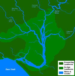
Tributaries and geographic features
The Yarra's major tributaries are the Maribyrnong RiverMaribyrnong river
The Maribyrnong River rises about 50 km north of Melbourne, Victoria , near Mount Macedon. It flows generally southward and combines with the Yarra River to flow into Port Phillip....
, Moonee Ponds Creek
Moonee Ponds Creek
The Moonee Ponds Creek is a creek and major tributary of the Yarra River running through urban Melbourne, Victoria, Australia from northern to inner suburbs...
, Merri Creek
Merri Creek
The Merri Creek is a waterway in southern parts of Victoria, Australia which flows through the northern suburbs of Melbourne. It begins in Wallan north of Melbourne and flows south for 70km until it joins the Yarra River at Dights Falls...
, Darebin Creek
Darebin Creek
Darebin Creek is a creek that runs through the northern suburbs of Melbourne, Victoria, Australia. It is the main watercourse of the Darebin Valley and a major tributary of the Yarra River...
, Plenty River
Plenty River
The Plenty River is a tributary of the Yarra River in Victoria, Australia. Originating in the forested slopes of Mount Disappointment, the Plenty River is the source of Melbourne's first major water supply in the form of the Yan Yean Reservoir....
, Mullum Mullum Creek and Olinda Creek
Olinda Creek
Olinda Creek is a major tributary of the Yarra River in Victoria, Australia. Its origins are in the Dandenong Ranges, and it is notable for passing through the settlement of Lilydale before joining with the Yarra near Coldstream.....
. The river hosts many geographical features such as; bends, rapid
Rapid
A rapid is a section of a river where the river bed has a relatively steep gradient causing an increase in water velocity and turbulence. A rapid is a hydrological feature between a run and a cascade. A rapid is characterised by the river becoming shallower and having some rocks exposed above the...
s, lake
Lake
A lake is a body of relatively still fresh or salt water of considerable size, localized in a basin, that is surrounded by land. Lakes are inland and not part of the ocean and therefore are distinct from lagoons, and are larger and deeper than ponds. Lakes can be contrasted with rivers or streams,...
s, island
Island
An island or isle is any piece of sub-continental land that is surrounded by water. Very small islands such as emergent land features on atolls can be called islets, cays or keys. An island in a river or lake may be called an eyot , or holm...
s, floodplain
Floodplain
A floodplain, or flood plain, is a flat or nearly flat land adjacent a stream or river that stretches from the banks of its channel to the base of the enclosing valley walls and experiences flooding during periods of high discharge...
s, billabong
Billabong
Billabong is an Australian English word meaning a small lake, specifically an oxbow lake, a section of still water adjacent to a river, cut off by a change in the watercourse. Billabongs are usually formed when the path of a creek or river changes, leaving the former branch with a dead end...
s and wetland
Wetland
A wetland is an area of land whose soil is saturated with water either permanently or seasonally. Wetlands are categorised by their characteristic vegetation, which is adapted to these unique soil conditions....
s. Most features have been named after translated Wurundjeri
Wurundjeri
The Wurundjeri are a people of the Indigenous Australian nation of the Woiwurrung language group, in the Kulin alliance, who occupy the Birrarung Valley, its tributaries and the present location of Melbourne, Australia...
phrases or have European, particularly British
Great Britain
Great Britain or Britain is an island situated to the northwest of Continental Europe. It is the ninth largest island in the world, and the largest European island, as well as the largest of the British Isles...
, origins. Some of the river's more prominent features include; Coode Island and Fishermans Bend, Victoria Harbour
Victoria Harbour
Victoria Harbour is a natural landform harbour situated between Hong Kong Island and the Kowloon Peninsula in Hong Kong. The harbour's deep, sheltered waters and strategic location on the South China Sea were instrumental in Hong Kong's establishment as a British colony and its subsequent...
, Herring Island
Herring Island (Victoria)
Herring Island is a small island located in Melbourne's Yarra River at South Yarra, approximately 3 km from the city. Originally a quarry, it was leased by the scouts in the 1950s and 1960s and is currently managed by Parks Victoria and used as a sculpture park...
, Yarra Bend, Dights Falls, Upper Yarra Dam and Reservoir and many river flats and billabongs.
Settlements
- Greater Melbourne – 4 million
- Melbourne City CentreMelbourneMelbourne is the capital and most populous city in the state of Victoria, and the second most populous city in Australia. The Melbourne City Centre is the hub of the greater metropolitan area and the Census statistical division—of which "Melbourne" is the common name. As of June 2009, the greater...
– 20,500 - South Yarra – 18,000
- RichmondRichmond, VictoriaRichmond is a suburb in Melbourne, Victoria, Australia, 3 km south-east from Melbourne's central business district. Its Local Government Area is the City of Yarra...
– 22,500 - HawthornHawthorn, VictoriaHawthorn is a suburb in Melbourne, Victoria, Australia, east from Melbourne's central business district. Its Local Government Area is the City of Boroondara...
– 20,000 - FairfieldFairfield, VictoriaFairfield is a suburb in Melbourne, Victoria, Australia, 6 km north-east from Melbourne's central business district. Its Local Government Area are the Cities of Darebin and Yarra...
– 5,000 - HeidelbergHeidelberg, VictoriaHeidelberg is a suburb in Melbourne, Victoria, Australia, 11 km north-east from Melbourne's central business district. Its Local Government Area is the City of Banyule....
– 5,300 - Bulleen – 10,500
- TemplestoweTemplestowe, Victoria"Templestowe" redirects here. For the Victorian Legislative Council Province, please see Templestowe Province.Templestowe is a suburb in Melbourne, Victoria, Australia, 17 km north-east from Melbourne's central business district. Its Local Government Area is the City of Manningham...
– 16,500 - ElthamEltham, VictoriaEltham is a suburb in Melbourne, Victoria, Australia, 20 km north-east from Melbourne's central business district. Its Local Government Area is the Shire of Nillumbik. At the 2006 Census, Eltham had a population of 17,581....
– 17,600- Warrandyte – 10,000
- Yarra Glen – 2,600
- HealesvilleHealesville, VictoriaHealesville is a town in Victoria, Australia, 52 km north-east from Melbourne's central business district. Its Local Government Area is the Shire of Yarra Ranges...
– 6,500 - Woori Yallock – 2,800
- Launching PlaceLaunching Place, VictoriaLaunching Place is a town in Victoria, Australia, 54 km east from Melbourne's central business district. Its Local Government Area is the Shire of Yarra Ranges...
– 2,600 - Yarra Junction – 1,700
- WarburtonWarburton, VictoriaWarburton is a town in Victoria, Australia, 72 km east from Melbourne's central business district. Its Local Government Area is the Shire of Yarra Ranges. At the 2006 Census, Warburton had a population of 2288....
– 2,300 - McMahons Creek – 282
Marine ecology
The river is home to several species of fish. In the lower reaches of the Yarra mainly Southern black breamSouthern black bream
The southern black bream, Acanthopagrus butcheri, is a species of marine and freshwater fish of the porgy family, Sparidae...
and jellyfish
Jellyfish
Jellyfish are free-swimming members of the phylum Cnidaria. Medusa is another word for jellyfish, and refers to any free-swimming jellyfish stages in the phylum Cnidaria...
and in the upper reachers smaller quantities of European perch
European perch
The European perch, Perca fluviatilis, is a predatory species of perch found in Europe and Asia. In some areas it is known as the redfin perch or English perch, and it is often known simply as perch. The species is a popular quarry for anglers and has been widely introduced beyond its native area,...
(redfin), Macquarie Perch
Macquarie perch
The Macquarie perch is an Australian native freshwater fish of the Murray-Darling river system. It is a member of the Percichthyidae family and is closely related to the golden perch ....
, Brown Trout
Brown trout
The brown trout and the sea trout are fish of the same species....
, Murray Cod
Murray Cod
The Murray cod is a large Australian predatory freshwater fish of the Maccullochella genus and the Percichthyidae family. Although the species is a called cod in the vernacular, it is not related to the northern hemisphere marine cod species...
and Freshwater Catfish
Freshwater catfish
Siluridae is a family of catfish . They are sometimes known as sheatfish, although that name may also be used more specifically for Silurus glanis, the wels catfish...
. However almost all of the fish are contaminated with heavy metals including arsenic
Arsenic
Arsenic is a chemical element with the symbol As, atomic number 33 and relative atomic mass 74.92. Arsenic occurs in many minerals, usually in conjunction with sulfur and metals, and also as a pure elemental crystal. It was first documented by Albertus Magnus in 1250.Arsenic is a metalloid...
and not fit for human consumption. Dolphins have been known to venture upstream as far as South Yarra, and serve as an example of the increased salinity of the river's lower reaches.
Upper reaches
The river's source is a series of swampSwamp
A swamp is a wetland with some flooding of large areas of land by shallow bodies of water. A swamp generally has a large number of hammocks, or dry-land protrusions, covered by aquatic vegetation, or vegetation that tolerates periodical inundation. The two main types of swamp are "true" or swamp...
s in the upper reaches of the Yarra Ranges National Park
Yarra Ranges National Park
Yarra Ranges is a national park in Victoria, Australia, 92 km east of Melbourne. It covers the headwaters of the Yarra River in the ranges themselves and several water catchments for Melbourne's domestic water supply....
, directly to the west of the Mount Baw Baw
Mount Baw Baw
Mount Baw Baw is a mountain in Victoria, Australia. Mount Baw Baw Alpine Resort is an Unincorporated area of Victoria surrounded by the Shire of Baw Baw.-Location:...
plateau, a thickly forested subalpine park, which is entirely closed-off to all except the employees of Melbourne Water
Melbourne Water
Melbourne Water is a government owned statutory authority that controls much of the water system in Melbourne, Victoria, Australia including the reservoirs, and thesewerage and drainage system that services the city.- Overview :...
. The park features extensive stands of mountain ash
Eucalyptus regnans
Eucalyptus regnans, known variously by the common names Mountain Ash, Victorian Ash, Swamp Gum, Tasmanian Oak or Stringy Gum, is a species of Eucalyptus native to southeastern Australia, in Tasmania and Victoria...
, a very tall eucalypt
Eucalypt
Eucalypts are woody plants belonging to three closely related genera:Eucalyptus, Corymbia and Angophora.In 1995 new evidence, largely genetic, indicated that some prominent Eucalyptus species were actually more closely related to Angophora than to the other eucalypts; they were split off into the...
, tree ferns, as well as patches of remnant rainforest.
The Upper Yarra Dam
Upper Yarra Dam
The Upper Yarra Reservoir is located east of Melbourne, beyond Warburton within the locality of Reefton. Water from Upper Yarra Reservoir supplies towns in the upper Yarra Valley, and Silvan Reservoir, which transfers water to most parts of Melbourne....
, one of a number of dams in the Yarra Catchment that supply a large part of Melbourne
Melbourne
Melbourne is the capital and most populous city in the state of Victoria, and the second most populous city in Australia. The Melbourne City Centre is the hub of the greater metropolitan area and the Census statistical division—of which "Melbourne" is the common name. As of June 2009, the greater...
's water, is the furthest upstream point on the river visible to the general public (though the dam itself is closed off). The first settlement the still-young river passes through is the small town of Reefton, but most of the river is surrounded by hills covered temperate forest until the timber and resort town of Warburton
Warburton, Victoria
Warburton is a town in Victoria, Australia, 72 km east from Melbourne's central business district. Its Local Government Area is the Shire of Yarra Ranges. At the 2006 Census, Warburton had a population of 2288....
. The Woods Point Rd follows the river through this section.
Woori Yallock, Victoria
Woori Yallock is a town in Victoria, Australia, 56 km east of Melbourne's central business district. Its Local Government Area is the Shire of Yarra Ranges...
and the river's turn north, increasingly large areas are covered by vineyards, forming the Yarra Valley
Yarra Valley
The Yarra Valley is the name given to the region surrounding the Yarra River in Victoria, Australia. The river originates approximately 90 kilometres east of the City of Melbourne and flows towards it and out into Port Phillip Bay...
wine region. At Healesville
Healesville, Victoria
Healesville is a town in Victoria, Australia, 52 km north-east from Melbourne's central business district. Its Local Government Area is the Shire of Yarra Ranges...
, the river turns west again and the stream bed becomes increasingly silty, reducing the clarity of the water, and by the commuter town of Yarra Glen
Yarra Glen, Victoria
Yarra Glen is a town in Victoria, Australia, 40 km north-east from Melbourne's central business district. Its Local Government Area is the Shire of Yarra Ranges...
it begins to take on the brownish colour that the lower reaches are known for.
Middle reaches
Bicycle
A bicycle, also known as a bike, pushbike or cycle, is a human-powered, pedal-driven, single-track vehicle, having two wheels attached to a frame, one behind the other. A person who rides a bicycle is called a cyclist, or bicyclist....
and walking trail known as the Main Yarra Trail begins at Warrandyte
Warrandyte, Victoria
Warrandyte is a suburb in Melbourne, Victoria, Australia, 24 km north-east from Melbourne's central business district. Its Local Government Area is the City of Manningham...
and becomes the Yarra River Trail, and in the lower reaches, the Capital City Trail
Capital City Trail
The Capital City Trail is a shared use path for cyclists and pedestrians, which circles the Melbourne city centre and some inner eastern and northern suburbs of Melbourne, Victoria, Australia....
. The river is used extensively for kayaking at Templestowe
Templestowe, Victoria
"Templestowe" redirects here. For the Victorian Legislative Council Province, please see Templestowe Province.Templestowe is a suburb in Melbourne, Victoria, Australia, 17 km north-east from Melbourne's central business district. Its Local Government Area is the City of Manningham...
, and canoes can often be seen throughout the suburban section. Whilst the water is not particularly clear, its quality is sufficient for edible fish to swim within it. Some small hobby farms are located in the floodplain area of the river, surprisingly close to central Melbourne and almost completely surrounded by suburbs.
Heidelberg formed the home of the Heidelberg School
Heidelberg School
The Heidelberg School was an Australian art movement of the late 19th century. The movement has latterly been described as Australian Impressionism....
, widely considered the first European painters to accurately capture the Australian landscape and its distinctive features. The walking trail features placards displaying some of their paintings at the settings they were actually painted; some features depicted remain clearly recognisable today.
Lower reaches
Dights Falls
Dights Falls is located in Melbourne, Victoria just downstream of the junction of the Yarra River with Merri Creek. At this point the river narrows and is constricted between 800,000 year old volcanic, basaltic lava flow and a much older steep, silurian, sedimentary spur...
at Yarra Bend Park in inner Melbourne, the river becomes increasingly estuarine as it passes along the southern side of the central business district. This area forms the venue for the annual "Moomba
Moomba
Moomba is Australia's largest free community festival and one of the longest running festivals in Australia. Held annually in the city of Melbourne, Australia, Moomba is celebrated during the Labour Day long weekend , and has been celebrated since 1955...
" festival, which notably features an annual water skiing
Water skiing
thumb|right|A slalom skier making a turn on a slalom waterski.Waterskiing is a sport where an individual is pulled behind a boat or a cable ski installation on a body of water, skimming the surface.-History:...
competition which attracts a huge crowd. The lower stretch of the river from Docklands to the Melbourne Cricket Ground
Melbourne Cricket Ground
The Melbourne Cricket Ground is an Australian sports stadium located in Yarra Park, Melbourne and is home to the Melbourne Cricket Club. It is the tenth largest stadium in the world, the largest in Australia, the largest stadium for playing cricket, and holds the world record for the highest light...
was part of the final path of the Queen's Baton Relay
Queen's Baton Relay
The Queen's Baton Relay, similar to the Olympic Torch Relay, is a relay around the world held prior to the beginning of the Commonwealth Games. The Baton carries a message from the Head of the Commonwealth, currently Queen Elizabeth II. The Relay traditionally begins at Buckingham Palace in London...
of the 2006 Commonwealth Games
2006 Commonwealth Games
The 2006 Commonwealth Games were held in Melbourne, Victoria, Australia between 15 March and 26 March 2006. It was the largest sporting event to be staged in Melbourne, eclipsing the 1956 Summer Olympics in terms of the number of teams competing, athletes competing, and events being held.The site...
. Many of Melbourne's private schools, located close to the river, train their rowing
Sport rowing
Rowing is a sport in which athletes race against each other on rivers, on lakes or on the ocean, depending upon the type of race and the discipline. The boats are propelled by the reaction forces on the oar blades as they are pushed against the water...
crews on it.
The lower reaches feature a number of boat cruises, using especially low-roof boats to go under the many bridges across this section of the Yarra. Herring Island
Herring Island (Victoria)
Herring Island is a small island located in Melbourne's Yarra River at South Yarra, approximately 3 km from the city. Originally a quarry, it was leased by the scouts in the 1950s and 1960s and is currently managed by Parks Victoria and used as a sculpture park...
is a small island at South Yarra which has a punt which takes people on to the park. The area in front of old Customs House is a former turning basin for ships. It is the point which was once known as "Freshwater Place" and once had a set of cascades which prevented both salt water and larger ships from going further upstream. This series of rocks, originally used to cross the river, and referred to as the "Yarra Falls" was removed using explosives and divers in 1883.
The final section passes through the Port of Melbourne
Port of Melbourne
The Port of Melbourne is Australia's busiest port for containerised and general cargo. It is located in Melbourne, Victoria and covers an area at the mouth of the Yarra River, downstream of Bolte Bridge, which is at the head of Port Phillip, as well as several piers on the bay itself...
and under the Bolte Bridge
Bolte Bridge
The Bolte Bridge is a large twin Cantilever bridge in Melbourne, Victoria, Australia. It spans the Yarra River and Victoria Harbour in the Docklands precinct to the west of the Melbourne CBD...
and the West Gate Bridge
West Gate Bridge
The West Gate Bridge is a steel box girder cable-stayed bridge in Melbourne, Victoria, Australia. It spans the Yarra River, just north of its mouth into Port Phillip, and is a vital link between the inner city and Melbourne's western suburbs with the industrial suburbs in the west and with the city...
. The current course dates back to 1886 when a canal devised by British engineer Sir John Coode
John Coode (engineer)
Sir John Coode , English civil engineer, was born at Bodmin, Cornwall, the son of a solicitor. After considerable experience as an engineer in the west of England he came to London, and from 1844 to 1847 had a consulting practice in Westminster.In the latter year he was appointed resident engineer...
was cut from west of Flinders Street to below its junction with the Maribyrnong. The resulting island between the new and old courses of the river was named Coode Island, and is now part of the mainland with the former course to the north filled in. The river flows into Port Phillip
Port Phillip
Port Phillip Port Phillip Port Phillip (also commonly referred to as Port Phillip Bay or (locally) just The Bay, is a large bay in southern Victoria, Australia; it is the location of Melbourne. Geographically, the bay covers and the shore stretches roughly . Although it is extremely shallow for...
, the site being extensively altered as part of the Port of Melbourne, Australia's busiest seaport.
Crossings
West Gate Bridge
The West Gate Bridge is a steel box girder cable-stayed bridge in Melbourne, Victoria, Australia. It spans the Yarra River, just north of its mouth into Port Phillip, and is a vital link between the inner city and Melbourne's western suburbs with the industrial suburbs in the west and with the city...
, Bolte
Bolte Bridge
The Bolte Bridge is a large twin Cantilever bridge in Melbourne, Victoria, Australia. It spans the Yarra River and Victoria Harbour in the Docklands precinct to the west of the Melbourne CBD...
and Princes Bridges, and the Burnley
Burnley Tunnel
The Burnley Tunnel is a tollway tunnel in Melbourne, in Victoria, Australia, which carries traffic eastbound from the West Gate Freeway to the Monash Freeway. It is part of the CityLink Tollway operated by Transurban. Running under the Yarra River and the inner suburbs of Richmond and Burnley, the...
and Domain
Domain Tunnel
The Domain Tunnel is a road tunnel located in Melbourne, Australia, which carries traffic westbound from the Monash Freeway to the West Gate Freeway, running under the Yarra River and Kings Domain...
Tunnels. Small historical bridges can be found further downstream including the Banksia Street, Fitzsimons Lane and Warrandyte Bridges. Beyond Warburton
Warburton, Victoria
Warburton is a town in Victoria, Australia, 72 km east from Melbourne's central business district. Its Local Government Area is the Shire of Yarra Ranges. At the 2006 Census, Warburton had a population of 2288....
there are very few crossings available. Some of the more prominent and historical crossings include;
- West Gate BridgeWest Gate BridgeThe West Gate Bridge is a steel box girder cable-stayed bridge in Melbourne, Victoria, Australia. It spans the Yarra River, just north of its mouth into Port Phillip, and is a vital link between the inner city and Melbourne's western suburbs with the industrial suburbs in the west and with the city...
– 1978 - Bolte BridgeBolte BridgeThe Bolte Bridge is a large twin Cantilever bridge in Melbourne, Victoria, Australia. It spans the Yarra River and Victoria Harbour in the Docklands precinct to the west of the Melbourne CBD...
– 1999 - Sandridge Bridge – 1888
- Princes Bridge – 1844, 1850, 1888
- CityLinkCityLinkCityLink is a system of tolled urban Highways in Melbourne, Victoria, Australia. The company Transurban was awarded the contract to augment two existing freeways and construct two new Toll roads—labelled the Western and Southern Links—directly linking a number of existing freeways to...
Tunnels – 1997 - Morell BridgeMorell BridgeThe Morell Bridge is a bridge over the Yarra River in South Yarra, Melbourne, Australia. Completed in 1899 by John Monash and J. T. N. Anderson, it is notable for being the first bridge in Victoria to be built using reinforced concrete....
– 1899 - Johnston Street Bridge – 1858
- Warrandyte Bridge – 1861, 1952
Parklands
Several reserves have been set aside adjoining the Yarra, mostly to preserve the natural environment or for recreation, many of these are managed and operated by Parks Victoria
Parks Victoria
-Department:Parks Victoria was established in December 1996 as a statutory authority, reporting to the Minister for Environment and Climate Change. The Parks Victoria Act 1998 makes Parks Victoria responsible for managing national parks, reserves and other land under the control of the state,...
, the state government agency responsible for the management of Victoria's national parks and other reserves. The largest and most notable of these parklands include: the Royal Botanic Gardens
Royal Botanic Gardens, Melbourne
The Royal Botanic Gardens Melbourne are internationally renowned botanical gardens located near the centre of Melbourne, Victoria, Australia, on the south bank of the Yarra River. They are 38 hectares of landscaped gardens consisting of a mix of native and non-native vegetation including over...
, Birrarung Marr, Yarra Bend Park, Westerfolds Park, Warrandyte State Park
Warrandyte State Park
Warrandyte State Park is a state park, located in Warrandyte, east of Melbourne, Victoria on the banks of the Yarra River and surroundings. The park comprises 586 hectares of remnant bushland in various locations throughout Warrandyte and Wonga Park around Pound Bend, Fourth Hill, Black Flat, Yarra...
and the Yarra Ranges National Park
Yarra Ranges National Park
Yarra Ranges is a national park in Victoria, Australia, 92 km east of Melbourne. It covers the headwaters of the Yarra River in the ranges themselves and several water catchments for Melbourne's domestic water supply....
.
Major parks
Some of the larger parklands adjoining the river include, from downstream to upstream:- Royal Botanic GardensRoyal Botanic Gardens, MelbourneThe Royal Botanic Gardens Melbourne are internationally renowned botanical gardens located near the centre of Melbourne, Victoria, Australia, on the south bank of the Yarra River. They are 38 hectares of landscaped gardens consisting of a mix of native and non-native vegetation including over...
- Birrarung Marr
- Yarra Bend Park
- Westerfolds Park
- Warrandyte State ParkWarrandyte State ParkWarrandyte State Park is a state park, located in Warrandyte, east of Melbourne, Victoria on the banks of the Yarra River and surroundings. The park comprises 586 hectares of remnant bushland in various locations throughout Warrandyte and Wonga Park around Pound Bend, Fourth Hill, Black Flat, Yarra...
- Yarra Ranges National ParkYarra Ranges National ParkYarra Ranges is a national park in Victoria, Australia, 92 km east of Melbourne. It covers the headwaters of the Yarra River in the ranges themselves and several water catchments for Melbourne's domestic water supply....
Golf courses
There are 14 golf courseGolf course
A golf course comprises a series of holes, each consisting of a teeing ground, fairway, rough and other hazards, and a green with a flagstick and cup, all designed for the game of golf. A standard round of golf consists of playing 18 holes, thus most golf courses have this number of holes...
s adjoining the river, these include, from downstream to upstream:
- Burnley Golf Course (9)
- Studley Park Golf Course (9)
- Yarra Bend Public Golf Course (18)
- Latrobe Golf Course (18)
- Green Acres Golf Club (18)
- Kew Golf ClubKew, VictoriaKew is a suburb in Melbourne, Victoria, Australia, 6 km east from Melbourne's central business district. Its Local Government Area is the City of Boroondara. At the 2006 Census, Kew had a population of 22,516....
(18) - Ivanhoe Public Golf CourseIvanhoe, VictoriaIvanhoe is a suburb in Melbourne, Victoria, Australia, 10 km north-east from Melbourne's central business district. Its Local Government Area is the City of Banyule. At the 2006 Census, Ivanhoe had a population of 10,600.-History:...
(18) - Freeway Public Golf Course (18)
- Yarra Valley Country Club (9)
- Bulleen Driving Range
- Rosanna Golf ClubRosanna, VictoriaRosanna is a suburb in Melbourne, Victoria, Australia, 12 km north-east from Melbourne's central business district. Its Local Government Area is the City of Banyule...
(18) - The Heritage Golf and Country Club
- Henly Course (18)
- St. John Course (18)
- Warburton Golf Club (18)
Popular culture
- The Yarra has been captured in many famous paintings including some by the Heidelberg School.
- The annual MoombaMoombaMoomba is Australia's largest free community festival and one of the longest running festivals in Australia. Held annually in the city of Melbourne, Australia, Moomba is celebrated during the Labour Day long weekend , and has been celebrated since 1955...
festival celebrates the Yarra River's increasing cultural significance to Melbourne. - The river has featured in songs by the Whirling Furphies, titled "My Brown Yarra", and the Coodabeen Champions, titled "By the Banks of the Yarra".
- A poem entitled "Yara Yara" was written by Greek poet Nikos KavvadiasNikos KavvadiasNikos Kavvadias was a Greek poet and writer; currently one of the most popular poets in Greece, who used his travels around the world as a sailor, and life at sea and its adventures, as powerful metaphors for the escape of ordinary people outside the boundaries of reality.- Early life and...
in 1951. - A song entitled The Yarra Song was written by Billy BraggBilly BraggStephen William Bragg , better known as Billy Bragg, is an English alternative rock musician and left-wing activist. His music blends elements of folk music, punk rock and protest songs, and his lyrics mostly deal with political or romantic themes...
and included on the Australian edition of his 2002 album, England, Half English.
Recreational use
Boating
Boating is the leisurely activity of travelling by boat, or the recreational use of a boat whether powerboats, sailboats, or man-powered vessels , focused on the travel itself, as well as sports activities, such as fishing or water skiing...
, rowing
Rowing (sport)
Rowing is a sport in which athletes race against each other on rivers, on lakes or on the ocean, depending upon the type of race and the discipline. The boats are propelled by the reaction forces on the oar blades as they are pushed against the water...
, water skiing
Water skiing
thumb|right|A slalom skier making a turn on a slalom waterski.Waterskiing is a sport where an individual is pulled behind a boat or a cable ski installation on a body of water, skimming the surface.-History:...
, kayaking
Kayaking
Kayaking is the use of a kayak for moving across water. Kayaking and canoeing are also known as paddling. Kayaking is distinguished from canoeing by the sitting position of the paddler and the number of blades on the paddle...
, canoeing
Canoeing
Canoeing is an outdoor activity that involves a special kind of canoe.Open canoes may be 'poled' , sailed, 'lined and tracked' or even 'gunnel-bobbed'....
, swimming, fishing
Fishing
Fishing is the activity of trying to catch wild fish. Fish are normally caught in the wild. Techniques for catching fish include hand gathering, spearing, netting, angling and trapping....
, cycling
Cycling
Cycling, also called bicycling or biking, is the use of bicycles for transport, recreation, or for sport. Persons engaged in cycling are cyclists or bicyclists...
, running
Running
Running is a means of terrestrial locomotion allowing humans and other animals to move rapidly on foot. It is simply defined in athletics terms as a gait in which at regular points during the running cycle both feet are off the ground...
and walking
Walking
Walking is one of the main gaits of locomotion among legged animals, and is typically slower than running and other gaits. Walking is defined by an 'inverted pendulum' gait in which the body vaults over the stiff limb or limbs with each step...
, amongst other things. In the rivers upper reaches, fishing
Fishing
Fishing is the activity of trying to catch wild fish. Fish are normally caught in the wild. Techniques for catching fish include hand gathering, spearing, netting, angling and trapping....
is most popular. Upstream of Launching Place
Launching Place, Victoria
Launching Place is a town in Victoria, Australia, 54 km east from Melbourne's central business district. Its Local Government Area is the Shire of Yarra Ranges...
the river becomes quite narrow and recreational use is limited. In the middle reaches, canoeing
Canoeing
Canoeing is an outdoor activity that involves a special kind of canoe.Open canoes may be 'poled' , sailed, 'lined and tracked' or even 'gunnel-bobbed'....
and kayaking
Kayaking
Kayaking is the use of a kayak for moving across water. Kayaking and canoeing are also known as paddling. Kayaking is distinguished from canoeing by the sitting position of the paddler and the number of blades on the paddle...
is popular, there are a few rapids of easy to medium difficulty depending on the water level.
Swimming is also popular in the middle reaches throughout summer, particularly around Warrandyte, however, it should be noted that around this area there are submerged mining shafts which can cause undertows that suck swimmers under the surface and into these shafts. In the period 2004–08, 3 people died in this manner in Warrandyte alone. Swimming is safer downstream, but not advisable below Dights Falls
Dights Falls
Dights Falls is located in Melbourne, Victoria just downstream of the junction of the Yarra River with Merri Creek. At this point the river narrows and is constricted between 800,000 year old volcanic, basaltic lava flow and a much older steep, silurian, sedimentary spur...
due to the high levels of pollution.
In the lower reaches, the river is mostly used for rowing
Rowing (sport)
Rowing is a sport in which athletes race against each other on rivers, on lakes or on the ocean, depending upon the type of race and the discipline. The boats are propelled by the reaction forces on the oar blades as they are pushed against the water...
, there are several rowing sheds along the city stretch east of the Princes Bridge and many private schools have rowing clubs with sheds and berths on the river. At certain times of the year, particularly during the Moomba Festival, this stretch of the river is occupied by water skiing
Water skiing
thumb|right|A slalom skier making a turn on a slalom waterski.Waterskiing is a sport where an individual is pulled behind a boat or a cable ski installation on a body of water, skimming the surface.-History:...
courses and jumps. The banks of the Yarra River are popular for cycling
Cycling
Cycling, also called bicycling or biking, is the use of bicycles for transport, recreation, or for sport. Persons engaged in cycling are cyclists or bicyclists...
, running
Running
Running is a means of terrestrial locomotion allowing humans and other animals to move rapidly on foot. It is simply defined in athletics terms as a gait in which at regular points during the running cycle both feet are off the ground...
and walking
Walking
Walking is one of the main gaits of locomotion among legged animals, and is typically slower than running and other gaits. Walking is defined by an 'inverted pendulum' gait in which the body vaults over the stiff limb or limbs with each step...
where most paths are sealed and in good condition. Two major off-road, sealed trails, the Yarra River Trail and Capital City Trail
Capital City Trail
The Capital City Trail is a shared use path for cyclists and pedestrians, which circles the Melbourne city centre and some inner eastern and northern suburbs of Melbourne, Victoria, Australia....
follow the river on its course through the city, while part of the Bayside Trail also connects with the river.
The river is also popular for boating
Boating
Boating is the leisurely activity of travelling by boat, or the recreational use of a boat whether powerboats, sailboats, or man-powered vessels , focused on the travel itself, as well as sports activities, such as fishing or water skiing...
, in the residential suburb of Toorak
Toorak, Victoria
Toorak is a suburb of Melbourne, Victoria, Australia, 5 km south-east from Melbourne's central business district located on a rise on the south side of a bend in the Yarra River. Its Local Government Area is the City of Stonnington...
some of the larger mansions have private boat moorings, whilst newer developments in Melbourne Docklands have larger marinas as does Pier 31 at Fisherman's Bend and Newport and Williamstown at the river's mouth. Boating is difficult beyond Hawthorn
Hawthorn, Victoria
Hawthorn is a suburb in Melbourne, Victoria, Australia, east from Melbourne's central business district. Its Local Government Area is the City of Boroondara...
and impossible past Dights Falls
Dights Falls
Dights Falls is located in Melbourne, Victoria just downstream of the junction of the Yarra River with Merri Creek. At this point the river narrows and is constricted between 800,000 year old volcanic, basaltic lava flow and a much older steep, silurian, sedimentary spur...
. It is mostly concentrated in central Melbourne where cruises go up and down the river and ferries operate.
Navigation
The river can be used by any member of the public provided they abide by the rules of Parks Victoria who administer the river upstream of Bolte BridgeBolte Bridge
The Bolte Bridge is a large twin Cantilever bridge in Melbourne, Victoria, Australia. It spans the Yarra River and Victoria Harbour in the Docklands precinct to the west of the Melbourne CBD...
and the Port of Melbourne Corporation
Port of Melbourne Corporation
The Port of Melbourne Corporation is a statutory body established by the Victorian Government. The Corporation commenced operations on 1 July 2003, when it took over the management of the Port of Melbourne from Melbourne Port Corporation...
who administer the area downstream of Bolte Bridge. There is a maximum speed limit of 9 kilometres per hour (5 knots) for all boats operating on the river. Sections of the river are occasionally closed for public events such as Moomba
Moomba
Moomba is Australia's largest free community festival and one of the longest running festivals in Australia. Held annually in the city of Melbourne, Australia, Moomba is celebrated during the Labour Day long weekend , and has been celebrated since 1955...
, New Year's Eve and Rowing events.
The river is navigable by most boats from its entrance in Hobsons Bay to Dights Falls (a stretch of 22 km) and is subject to tidal variations and submerged objects. There are four bridges on the Yarra River with limited height clearances at high tide:
- Charles Grimes Bridge – 3.2 m (10.5 ft)
- Spencer Street BridgeSpencer Street BridgeThe Spencer Street Bridge is a road and tram bridge over the Yarra River in Melbourne, Victoria, Australia. It connects Spencer Street on the north bank with Clarendon Street on the south....
– 2.3 m (7.5 ft) (can be less than 2 m or 6.6 ft at extreme high tides – once a month) - Kings Bridge – 2.4 m (7.9 ft)
- Queens BridgeQueens Bridge (Melbourne)The Queens Bridge is a historic road bridge over the Yarra River in Melbourne, Victoria, Australia. The bridge was built in 1889 and has five wrought iron plate girder spans, and is listed on the Victorian Heritage Register...
– 2.4 m
See also
- Crossings of the Yarra River
- Geography of the Yarra RiverGeography of the Yarra RiverThe Yarra River is a river in East-Central Victoria, Australia that flows through the city of Melbourne. This article contains explanations and lists of the river's tributaries and other geographic features...
- Geology of VictoriaGeology of VictoriaVictoria is an Australian state, situated at the southern end of the Great Dividing Range. The Great Dividing Range stretches along the east coast of the continent and terminates near the Victorian city of Ballarat west of the capital Melbourne, though the nearby Grampians may be considered to be...
- Lakes and Reservoirs in MelbourneLakes and Reservoirs in MelbourneMelbourne is a city in south-eastern Australia. Most major lakes are used for recreational purposes, mostly sailing, rowing, canoeing and kayaking, but some are used for activities like water skiing or swimming...
- Parklands adjoining the Yarra RiverParklands adjoining the Yarra RiverThe Yarra River is a river in southern Victoria, Australia that flows through the city of Melbourne. There are many parklands, including state parks and national parks, that adjoin the river along its 250 km length. Every park listed has walking tracks, smaller parks usually have unsealed...
- Yarra Ranges National ParkYarra Ranges National ParkYarra Ranges is a national park in Victoria, Australia, 92 km east of Melbourne. It covers the headwaters of the Yarra River in the ranges themselves and several water catchments for Melbourne's domestic water supply....
- Yarra ValleyYarra ValleyThe Yarra Valley is the name given to the region surrounding the Yarra River in Victoria, Australia. The river originates approximately 90 kilometres east of the City of Melbourne and flows towards it and out into Port Phillip Bay...
Further reading
- Otto, K; Yarra, Melbourne: Text Publishing, 2005, (ISBN 1-920885-78-1)