
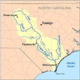
Cape Fear River
Overview
Blackwater river
A blackwater river is a river with a deep, slow-moving channel that flows through forested swamps and wetlands. As vegetation decays in the water, tannins are leached out, resulting in transparent, acidic water that is darkly stained, resembling tea or coffee. Most major blackwater rivers are in...
in east central North Carolina
North Carolina
North Carolina is a state located in the southeastern United States. The state borders South Carolina and Georgia to the south, Tennessee to the west and Virginia to the north. North Carolina contains 100 counties. Its capital is Raleigh, and its largest city is Charlotte...
in the United States
United States
The United States of America is a federal constitutional republic comprising fifty states and a federal district...
. It flows into the Atlantic Ocean
Atlantic Ocean
The Atlantic Ocean is the second-largest of the world's oceanic divisions. With a total area of about , it covers approximately 20% of the Earth's surface and about 26% of its water surface area...
near Cape Fear, from which it takes its name. The overall water quality of the river is continuously measured and monitored by Cape Fear River Watch and conducted by the UNCW Aquatic Ecology Laboratory, UNCW Benthic Ecology Laboratory, and the UNCW Icthyology and Fish Ecology Laboratory.