

Bogue Banks
Encyclopedia
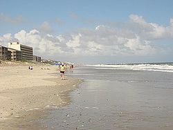
Barrier island
Barrier islands, a coastal landform and a type of barrier system, are relatively narrow strips of sand that parallel the mainland coast. They usually occur in chains, consisting of anything from a few islands to more than a dozen...
off the mainland of North Carolina
North Carolina
North Carolina is a state located in the southeastern United States. The state borders South Carolina and Georgia to the south, Tennessee to the west and Virginia to the north. North Carolina contains 100 counties. Its capital is Raleigh, and its largest city is Charlotte...
in Carteret County. The island, separated from the mainland by Bogue Sound
Bogue Sound
Bogue Sound is a medium-sized geographic sound in the state of North Carolina. It separates the Bogue Banks from mainland Carteret County. Morehead City's port is accessed via the Bogue Sound. Two bridges cross the sound: NC 58 on the B...
, runs east to west, with the ocean beaches facing due south. Bogue Banks is the only island on the Carteret County shore that has been developed with housing: numerous communities are located on the island and can be accessed by one of two bridges across Bogue Sound, either from Morehead City to Atlantic Beach
Atlantic Beach, North Carolina
-Demographics:As of the census of 2008, there were 1,815 people, 971 households, and 498 families residing in the town. The population density was . There were 4,728 housing units at an average density of 2,206.0 per square mile...
, which is the more heavily traveled bridge, or from Cape Carteret
Cape Carteret, North Carolina
Cape Carteret is a town in Carteret County, on the southern coast of North Carolina in the United States. It was incorporated in 1959 and had a population of 1,389 in 2008.-Geography:Cape Carteret is located at ....
to Emerald Isle
Emerald Isle, North Carolina
Emerald Isle is a town in Carteret County, North Carolina, United States. It is part of the Crystal Coast and is located entirely on the Bogue Banks...
. The communities of Bogue Banks are the most prominent of the Crystal Coast
Crystal Coast
The Crystal Coast is an 85-mile stretch of coastline in North Carolina that extends from the Cape Lookout National Seashore, which includes 56 miles of protected beaches, westward to the New River. It is also known as the Southern Outer Banks and is a popular area with tourists and second-home...
. NC 58 traverses a majority of the island's length. There are several hotels that dot the island, but most of the land contains private houses, which are rented out during the summer, or maritime forest. Stores and other commercial properties are limited to the five main communities.
Points of interest
The Emerald Isle Coast GuardUnited States Coast Guard
The United States Coast Guard is a branch of the United States Armed Forces and one of the seven U.S. uniformed services. The Coast Guard is a maritime, military, multi-mission service unique among the military branches for having a maritime law enforcement mission and a federal regulatory agency...
Station is located on the western end of Bogue Banks; Fort Macon State Park
Fort Macon State Park
Fort Macon State Park is a North Carolina state park in Carteret County, North Carolina, in the United States. Located on Bogue Banks near Atlantic Beach, the park opened in 1936...
, located on the eastern end, beyond Atlantic Beach, saw action during the Civil War
American Civil War
The American Civil War was a civil war fought in the United States of America. In response to the election of Abraham Lincoln as President of the United States, 11 southern slave states declared their secession from the United States and formed the Confederate States of America ; the other 25...
; there the ornithologist and naturalist Elliott Coues
Elliott Coues
Elliott Coues was an American army surgeon, historian, ornithologist and author.Coues was born in Portsmouth, New Hampshire. He graduated at Columbian University, Washington, D.C., in 1861, and at the Medical school of that institution in 1863...
spent two years, 1869–70, as US Army surgeon, taking the opportunity to study the sea birds, marsh birds and shore birds that nested there, noting lynx
Lynx
A lynx is any of the four Lynx genus species of medium-sized wildcats. The name "lynx" originated in Middle English via Latin from Greek word "λύγξ", derived from the Indo-European root "*leuk-", meaning "light, brightness", in reference to the luminescence of its reflective eyes...
and mink
Mink
There are two living species referred to as "mink": the European Mink and the American Mink. The extinct Sea Mink is related to the American Mink, but was much larger. All three species are dark-colored, semi-aquatic, carnivorous mammals of the family Mustelidae, which also includes the weasels and...
, "describing a coastal world scarcely touched by commercial fishing, much less by the unrestrained tourism and real-estate development of today". Today, with some of the highest sand dunes on the East Coast, it is North Carolina's most visited state park. The North Carolina Aquarium, one of three, is located in Pine Knoll Shores in the middle of the island. Surrounding the aquarium is the Theodore Roosevelt Natural Area, a 265 acres (1.1 km²) maritime forest owned, maintained and protected by the state. It is one of the few remaining maritime forest
Maritime forest
A maritime forest is an ocean coastal wooded habitat found on higher ground than dune areas within range of salt spray. They can be found along the Atlantic coast of the United States...
s on North Carolina's barrier islands. A historic marker stands at the corner of N.C. 58 and Roosevelt Boulevard (at mile marker 7), noting the spot of the first landing of Europeans on the North Carolina coast. Giovanni da Verrazano
Giovanni da Verrazano
Giovanni da Verrazzano was an Italian explorer of North America, in the service of the French crown. He is renowned as the first European since the Norse expeditions to North America around AD 1000 to explore the Atlantic coast of North America between the Carolinas and Newfoundland, including New...
, a Florentine navigator
Navigator
A navigator is the person on board a ship or aircraft responsible for its navigation. The navigator's primary responsibility is to be aware of ship or aircraft position at all times. Responsibilities include planning the journey, advising the Captain or aircraft Commander of estimated timing to...
in the service of France
France
The French Republic , The French Republic , The French Republic , (commonly known as France , is a unitary semi-presidential republic in Western Europe with several overseas territories and islands located on other continents and in the Indian, Pacific, and Atlantic oceans. Metropolitan France...
, explored the state's coast from Cape Fear to Kitty Hawk
Kitty Hawk
Kitty Hawk or Kittyhawk may refer to:Places*Kitty Hawk, North Carolina*Kitty Hawk, is an area of Wright-Patterson Air Force Base*Kitty Hawk Air Society, an Honor Society for the Air Force Junior Reserve Officers' Training Corps programAirlines...
in 1524. His voyage along the coast marked the first recorded European contact with what is now North Carolina.
Salter Path
The decline in the whaling industryWhaling
Whaling is the hunting of whales mainly for meat and oil. Its earliest forms date to at least 3000 BC. Various coastal communities have long histories of sustenance whaling and harvesting beached whales...
in the mid-to-late 19th century and good fishing
Fishing
Fishing is the activity of trying to catch wild fish. Fish are normally caught in the wild. Techniques for catching fish include hand gathering, spearing, netting, angling and trapping....
on Bogue Banks caused many settlers, mostly near Cape Lookout
Cape Lookout (North Carolina)
This article is about the Cape Lookout in North Carolina. See Cape Lookout for other places with a similar name. Cape Lookout is southern point of the Core Banks, one of the natural barrier islands on the Atlantic coast of North Carolina, USA. delimits Onslow Bay to the west from Raleigh Bay to...
(Diamond City), to move toward the middle and western reaches of Bogue Banks. The community of Salter Path is believed to be named after Owen Salter or possibly Riley Salter although Riley Salter’s true whereabouts during the 1880s has been questioned by historians and native Bogue Bankers. Schools of mullet
Mullet (fish)
The mullets or grey mullets are a family and order of ray-finned fish found worldwide in coastal temperate and tropical waters, and in some species in fresh water. Mullets have served as an important source of food in Mediterranean Europe since Roman times...
that ran close to the ocean shorelines were the prime catch for many of the natives. These fishermen would quickly tramp from the sound to the ocean, wearing a path in front of a Salter household, hence the name Salter Path. Many of the families who moved to Salter Path in the late 19th century and early 20th century established their residences without deeds before Bostonian John A. Royal purchased Salter Path. The area of Salter Path subsequently became known as a squatters'
Squatting
Squatting consists of occupying an abandoned or unoccupied space or building, usually residential, that the squatter does not own, rent or otherwise have permission to use....
community.
Salter Path was passed from John A. Royal to Alice Green Hoffman, a distant relative of Theodore Roosevelt
Theodore Roosevelt
Theodore "Teddy" Roosevelt was the 26th President of the United States . He is noted for his exuberant personality, range of interests and achievements, and his leadership of the Progressive Movement, as well as his "cowboy" persona and robust masculinity...
and daughter of Alfred Green
Alfred Green
Alfred E. Green was a prolific movie director. Green entered film in 1912 as an actor for the Selig Polyscope Company. He became an assistant to director Colin Campbell...
, a former governor of New Jersey. Alice Hoffman developed an estate
Estate (house)
An estate comprises the houses and outbuildings and supporting farmland and woods that surround the gardens and grounds of a very large property, such as a country house or mansion. It is the modern term for a manor, but lacks the latter's now abolished jurisdictional authority...
in present day Pine Knoll Shores and sued the residents of Salter Path in 1923 because their cows were wandering onto her estate. A subsequent court decision permitted the residents of Salter Path to remain, but the cows were not allowed to graze on the Hoffman estate. The village was restricted to 81 acres (327,795.7 m²) that the squatters occupied, and direct ownership of the beachfront was granted to the village to use collectively. This ruling further stated that only current residents and descendents could occupy the property, but it did not give any individuals title
Title (property)
Title is a legal term for a bundle of rights in a piece of property in which a party may own either a legal interest or an equitable interest. The rights in the bundle may be separated and held by different parties. It may also refer to a formal document that serves as evidence of ownership...
to the land. This ruling remained intact until 1979 when a legal settlement permitted Salter Path residents to hold title to their property and for Carteret County to levy taxes on the former squatter’s village.
Communities
The following are communities on the Bogue Banks:- Atlantic BeachAtlantic Beach, North Carolina-Demographics:As of the census of 2008, there were 1,815 people, 971 households, and 498 families residing in the town. The population density was . There were 4,728 housing units at an average density of 2,206.0 per square mile...
- Emerald IsleEmerald Isle, North CarolinaEmerald Isle is a town in Carteret County, North Carolina, United States. It is part of the Crystal Coast and is located entirely on the Bogue Banks...
- Indian BeachIndian Beach, North CarolinaIndian Beach is a town in Carteret County, North Carolina, United States. The population was 93 in 2009.-Geography:Indian Beach is located at ....
- Pine Knoll ShoresPine Knoll Shores, North CarolinaPine Knoll Shores is a town in Carteret County, North Carolina, United States. The population was 1,547 at the 2008 census. One of North Carolina's state aquariums is located here.-Geography:Pine Knoll Shores is located at ....
- Salter PathSalter Path, North CarolinaSalter Path is an unincorporated community in Carteret County, North Carolina, United States. A Crystal Coast community, it lies on Bogue Banks between the towns of Emerald Isle and Indian Beach.-History:...
Surrounding waters
- Onslow BayOnslow BayOnslow Bay is an indentation of the North Carolina coast, between Cape Fear in the south and Cape Lookout in the north. Thirteen barrier islands form the shore of the bay. It is part of the open Atlantic Ocean and affords no protection from oceanic swells....
(Atlantic OceanAtlantic OceanThe Atlantic Ocean is the second-largest of the world's oceanic divisions. With a total area of about , it covers approximately 20% of the Earth's surface and about 26% of its water surface area...
) - south - Bogue SoundBogue SoundBogue Sound is a medium-sized geographic sound in the state of North Carolina. It separates the Bogue Banks from mainland Carteret County. Morehead City's port is accessed via the Bogue Sound. Two bridges cross the sound: NC 58 on the B...
(Intracoastal WaterwayIntracoastal WaterwayThe Intracoastal Waterway is a 3,000-mile waterway along the Atlantic and Gulf coasts of the United States. Some lengths consist of natural inlets, salt-water rivers, bays, and sounds; others are artificial canals...
) - north - Bogue Inlet - west
- Beaufort Inlet - east
- White Oak RiverWhite Oak RiverThe White Oak River is a blackwater river, approximately 40 mi long, on the coastal plain of southeast North Carolina in the United States. It empties in the Atlantic Ocean.-Course:...
- northwest - Newport RiverNewport RiverThe Newport River is a small river in North Carolina that runs approximately twenty kilometers southeast through the town of Newport with its mouth opening into Bogue Sound, between Morehead City and Beaufort. It is popular for flatwater paddling and canoeing....
- northeast
Bogue Inlet Fishing Pier
The Bogue Inlet Fishing Pier, located on the western end of the Bogue Banks is one of the only fishing piers left on the island. In 2006, a beachfront development company applied to purchase the pier's land for the construction of condoCondominium
A condominium, or condo, is the form of housing tenure and other real property where a specified part of a piece of real estate is individually owned while use of and access to common facilities in the piece such as hallways, heating system, elevators, exterior areas is executed under legal rights...
s. Many area residents and Emerald Isle
Emerald Isle, North Carolina
Emerald Isle is a town in Carteret County, North Carolina, United States. It is part of the Crystal Coast and is located entirely on the Bogue Banks...
city officials are now petition
Petition
A petition is a request to do something, most commonly addressed to a government official or public entity. Petitions to a deity are a form of prayer....
ing to stop demolition of the pier.