
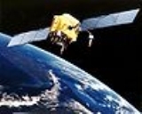
Global Positioning System
Overview
Global Navigation Satellite System
A satellite navigation or SAT NAV system is a system of satellites that provide autonomous geo-spatial positioning with global coverage. It allows small electronic receivers to determine their location to within a few metres using time signals transmitted along a line-of-sight by radio from...
(GNSS) that provides location
Positioning system
A positioning system is a mechanism for determining the location of an object in space. Technologies for this task exist ranging from worldwide coverage with meter accuracy to workspace coverage with sub-millimetre accuracy.- Interplanetary systems :...
and time information in all weather, anywhere on or near the Earth, where there is an unobstructed line of sight to four or more GPS satellites. It is maintained by the United States
United States
The United States of America is a federal constitutional republic comprising fifty states and a federal district...
government and is freely accessible by anyone with a GPS receiver with some technical limitations which are only removed for military users.
The GPS program provides critical capabilities to military, civil and commercial users around the world.