
Wrightsville Beach, North Carolina
Encyclopedia
New Hanover County, North Carolina
-Demographics:As of the census of 2000, there were 160,307 people, 68,183 households, and 41,591 families residing in the county. The population density was 806 people per square mile . There were 79,616 housing units at an average density of 400 per square mile...
, North Carolina
North Carolina
North Carolina is a state located in the southeastern United States. The state borders South Carolina and Georgia to the south, Tennessee to the west and Virginia to the north. North Carolina contains 100 counties. Its capital is Raleigh, and its largest city is Charlotte...
, United States
United States
The United States of America is a federal constitutional republic comprising fifty states and a federal district...
. Wrightsville Beach is just east of Wilmington
Wilmington, North Carolina
Wilmington is a port city in and is the county seat of New Hanover County, North Carolina, United States. The population is 106,476 according to the 2010 Census, making it the eighth most populous city in the state of North Carolina...
and is part of the Wilmington Metropolitan Statistical Area. The population was 2,593 at the 2000 census. The town consists of a four-mile-long beach island, an interior island called Harbor Island, and pockets of commercial property on the mainland.
History
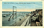
The island's first structure was the Carolina Yacht Club, built in 1853. A train track was built in 1888 from the mainland to Harbor Island to the exterior island along the beach, which brought vacationers from nearby Wilmington and spurred development. In 1902, the train was converted to electric streetcars—i.e., the beach trolley. The most significant structure on the island was the large dance floor and entertainment center, the Lumina Pavilion, which opened in 1905. In its heyday, it attracted numerous entertainers, including most of the famous Big Bands. Cars were finally allowed on the beach in 1935, hastening the demise of the beach trolley, which last ran in 1940. Lumina closed in 1973.The Wrightsville Beach Museum of History, housed in a relocated cottage built in 1907 on Salisbury Street near the entrance to the island, features the town's history. Many tourists come to see Wrightsville's history and beaches.
Recent history
Since the 1970s, development has increased at a rapid rate. A desalinationDesalination
Desalination, desalinization, or desalinisation refers to any of several processes that remove some amount of salt and other minerals from saline water...
plant was constructed in the middle of Harbor Island in 1960 by the Carrier Corporation. The method used to desalinize the water was freezing. The plant proved to be costly, inefficient and difficult to maintain. Residents also complained about the barely potable taste of the water. It was closed and is now used only as a water pumping station. Shell Island Resort, constructed on the northernmost end of the island in 1984, was considered controversial due to its large parking deck and its proximity to Mason Inlet. The construction of luxury condominiums at Duneridge, Sterling Edition at Wrightsville Dunes, and Cordgrass Bay occurred soon afterward. During the 1990s, Wrightsville Beach suffered from several hurricanes including Bertha
Hurricane Bertha (1996)
Hurricane Bertha was a strong, early season major hurricane which impacted areas from the Leeward Islands to Atlantic Canada. Bertha originated from a tropical wave which moved off the eastern coast of Africa in early July. By July 3, an area of low pressure developed along the wave...
, Fran
Hurricane Fran
Hurricane Fran was a powerful Cape Verde-type hurricane of the 1996 Atlantic hurricane season that made landfall near Cape Fear in North Carolina at Category 3 strength. Throughout the eastern United States, early statistics on Fran reported 27 deaths and $3.2 billion in damage...
, Irene
Hurricane Irene (1999)
Hurricane Irene was a hurricane that produced somewhat heavy damage across southern Florida during the 1999 Atlantic hurricane season. The ninth tropical storm and the sixth hurricane of the season, Irene developed in the western Caribbean Sea on October 13 from a tropical wave. It moved northward,...
, Bonnie
Hurricane Bonnie (1998)
Hurricane Bonnie was a major hurricane that made landfall in North Carolina, United States, inflicting severe crop damage. The second named storm, first hurricane, and first major hurricane of the 1998 Atlantic hurricane season, Bonnie developed from a tropical wave that emerged off the coast of...
, Dennis
Hurricane Dennis (1999)
Hurricane Dennis was an Atlantic hurricane that affected the Bahamas and parts of the Mid-Atlantic and Northeast during the 1999 Atlantic hurricane season. The fifth tropical cyclone, fourth tropical storm, and third hurricane of the season, Dennis originated from a tropical wave that passed north...
and Floyd
Hurricane Floyd
Hurricane Floyd was the sixth named storm, fourth hurricane, and third major hurricane in the 1999 Atlantic hurricane season. Floyd triggered the third largest evacuation in US history when 2.6 million coastal residents of five states were ordered from their homes as it approached...
. Although these hurricanes caused great destruction on the beach, the growth of the island has continued to flourish. In the late 1990s, it became increasingly apparent that Mason's Inlet at the northernmost part of the island was drifting southward. Residents became alarmed that Shell Island Resort and other high value residences would succumb to the Inlet. For some time, the northern side of the resort had to be strengthened by sandbags. The Army Corps of Engineers undertook a $6.5 million contract to move the inlet 3,000 feet north. On April 15, 2002, the project was completed and Wrightsville Beach gained a sizeable amount of virgin beach on its northern side. It is highly unlikely that any further development will occur north of Shell Island Resort.
In the 2000s, Hurricanes Isabel
Hurricane Isabel
Hurricane Isabel was the costliest and deadliest hurricane in the 2003 Atlantic hurricane season. The ninth named storm, fifth hurricane, and second major hurricane of the season, Isabel formed near the Cape Verde Islands from a tropical wave on September 6 in the tropical Atlantic Ocean...
, Charley
Hurricane Charley
Hurricane Charley was the third named storm, the second hurricane, and the second major hurricane of the 2004 Atlantic hurricane season. Charley lasted from August 9 to August 15, and at its peak intensity it attained 150 mph winds, making it a strong Category 4 hurricane on the...
and Ophelia
Hurricane Ophelia (2005)
Hurricane Ophelia was the fifteenth named tropical cyclone and the eighth hurricane of the 2005 Atlantic hurricane season. It was a long-lived storm that was most remembered for its very erratic and extremely slow track off the East Coast of the United States, alternating several times between...
affected Wrightsville Beach. These hurricanes were not as severe as those of the previous decade and many residents did not lose power.
Attractions
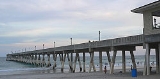
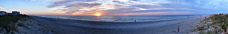
Naturally the primary attraction to Wrightsville is the beach itself. Johnny Mercer's Pier, located in the middle of Wrightsville Beach, is considered to be an excellent place for fishing. The pier used to be wooden, but was destroyed by Hurricane Fran in 1996. It was rebuilt with heavy concrete and opened in the early 2000s. Surfing is also very popular. The four primary hotels on the beach are The Surf Suites, Shell Island Resort, Blockade Runner and Holiday Inn Sunspree. There are several restaurants, stores, a gourmet grocery store and several marinas on Wrightsville Beach, and Harbor Island.Architecture
Many of the classic, old-fashioned beach cottages have been renovated or replaced over the years. The oldest of these early cottage dates to 1897. Construction, renewal and renovation are constantly occurring on the beach, even among houses built in the 1980s and 1990s.Geography
Wrightsville Beach is located at 34.211194°N 77.798636°W,Wrightsville Beach lies south of Figure Eight Island, separated by Mason Inlet
Mason Inlet
Mason Inlet is an ice-filled inlet which recedes 15 nautical miles southwest between Cape Mackintosh and the coastline south of Cape Herdman, along the east coast of Palmer Land. First seen and photographed from the air in December 1940 by members of the United States Antarctic Service...
, and north of Masonboro Island, separated by Masonboro Inlet
Masonboro Inlet
Masonboro Inlet is an inlet in New Hanover County, North Carolina, separating the town of Wrightsville Beach from Masonboro Island. The inlet was used as a hideout by Confederate blockade runners during the Civil War. The blockade runners would hide in the inlet until nightfall, then sail to the...
.
According to the United States Census Bureau
United States Census Bureau
The United States Census Bureau is the government agency that is responsible for the United States Census. It also gathers other national demographic and economic data...
, the town has a total area of 2.4 square miles (6.2 km²).1.3 square miles (3.4 km2) of it is land and 1.1 square miles (2.8 km²) of it (44.40%) is water.
Demographics
At the 2000 censusCensus
A census is the procedure of systematically acquiring and recording information about the members of a given population. It is a regularly occurring and official count of a particular population. The term is used mostly in connection with national population and housing censuses; other common...
, there were 2,593 people, 1,275 households and 566 families residing in the town. The population density
Population density
Population density is a measurement of population per unit area or unit volume. It is frequently applied to living organisms, and particularly to humans...
was 1,943.4 per square mile (752.8/km2). There were 3,050 housing units at an average density of 2,285.9 per square mile (885.4/km2). The racial makeup of the town was 98.11% White, 0.27% African American, 0.31% Native American, 0.54% Asian, 0.08% Pacific Islander, 0.19% from other races
Race (United States Census)
Race and ethnicity in the United States Census, as defined by the Federal Office of Management and Budget and the United States Census Bureau, are self-identification data items in which residents choose the race or races with which they most closely identify, and indicate whether or not they are...
, and 0.50% from two or more races. Hispanic or Latino of any race were 0.66% of the population.
There were 1,275 households of which 10.7% had children under the age of 18 living with them, 37.6% were married couples
Marriage
Marriage is a social union or legal contract between people that creates kinship. It is an institution in which interpersonal relationships, usually intimate and sexual, are acknowledged in a variety of ways, depending on the culture or subculture in which it is found...
living together, 4.0% had a female householder with no husband present, and 55.6% were non-families. 32.0% of all households were made up of individuals and 7.1% had someone living alone who was 65 years of age or older. The average household size was 2.02 and the average family size was 2.47.
Age distribution was 8.9% under the age of 18, 16.8% from 18 to 24, 34.0% from 25 to 44, 25.3% from 45 to 64, and 15.0% who were 65 years of age or older. The median age was 37 years. For every 100 females there were 125.3 males. For every 100 females age 18 and over, there were 126.1 males.
The median household income
Median household income
The median household income is commonly used to generate data about geographic areas and divides households into two equal segments with the first half of households earning less than the median household income and the other half earning more...
was $55,903, and the median family income was $71,641. Males had a median income of $35,388 versus $36,083 for females. The per capita income
Per capita income
Per capita income or income per person is a measure of mean income within an economic aggregate, such as a country or city. It is calculated by taking a measure of all sources of income in the aggregate and dividing it by the total population...
for the town was $36,575. About 2.0% of families and 9.5% of the population were below the poverty line, including 9.4% of those under age 18 and 2.2% of those age 65 or over.
External links
- Official website of Wrightsville Beach, NC
- Wrightsville Beach Chamber of Commerce
- Wrightsville Beach NC InsiderInfo.us Area Guide
- Wrightsville Beach: The Luminous Island book
- Lumina News, Wrightsville's Weekly Newspaper since May 2002
- WBLive Surf, Wrightsville Beach Live Surf Report and Streaming Web Cams hosted by http://www.AValive.com
- http://www.blockade-runner.com, The Historic Blockade Runner Beach Resort