
Geology of Alderley Edge
Encyclopedia
Alderley Edge
in Cheshire
is one of the classic locations for the study of Triassic
sandstones in the United Kingdom
. Numerous scientists from the early 19th century up to the present day have studied the area and it is a popular field site for universities around the UK. As time progresses, new theories are developed and new hypotheses are tested as to the origin of the sandstones. The information presented here provides the history and current (as of 2006) thoughts on the geological evolution of the sandstones at Alderley Edge.
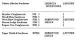
 The nomenclature of the English Triassic was rewritten in the 1980s and many of the previous names were changed. The classic terms ‘Bunter
’ and ‘Keuper
’ have now been abandoned, and the formations now recognized in the UK Triassic sequence
s, constitute three major lithostratigraphical
units,
For this reason, in places, the older names with appropriate cross references are used, in order to maintain an understanding of earlier work.
For a description of some of the other terms used see Geological unit
"The hill is evidently of alluvial formation, being composed chiefly of gravel and soft white and reddish sandstone
, - the white is intermixed with rounded quartz
pebbles, the red with particle of mica
. In some parts the red and white sandstone assume a nearly stratified
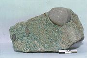
appearance, in others the red stone intersects the white in very thin seams, branching in various directions. In the white sandstone are found various ores of lead as small portions of galena
and in the same granular state intermixed with sandstone. In other places particles of blue and brown were collected in nodules
of various sizes and imbedded along with pebbles in the sand rock like currants in a pudding".
A few years later, Ormerod in his book the ‘History of Cheshire’
describes it as follows:
"Alderley Edge is an abrupt and elevated ridge, formerly the site of a beacon
, which bears the appearance of having been detached by some great convulsion of nature from the range of the Macclesfield
hills. Near the summit cobalt
ore, lead
and copper
have been got in small quantities. The sides are varied with cultivated land, wood and rock; and the entire mass presents a striking object to all the surrounding district over which it commands a most extensive prospect".
Basin is today one of the classic onshore localities in the UK for the study of Triassic
red-bed
fluvial
and aeolian sandstone sequences, and provides important insights to the nature and evolution of deformation in continental clastic natural gas
and petroleum reservoirs
, such as those of the Rotliegend
in the Southern North Sea
Gas Basin and of the Sherwood Sandstone
in the adjacent East Irish Sea
Basin. Analogues for cemented cataclastic faults, which can compartmentalise reservoirs, are well displayed by the arrays of deformation bands within the Alderley outcrop
s.
rates within the basin. Crustal uplift and erosion during the Tertiary were a direct result of reactivation of these earlier faults. Today active movement of the Wem-Red Rock fault system causes minor earthquakes across an area from North Wales
to Lancaster
. An interactive earthquake map can be found at the British Geological Survey Site.
The sediment infill of the basin is of Permian
to lower Jurassic
age and is up to 4.5 km thick in the south-east suggesting that greater and later subsidence occurred in the basin than in any other British Permo Triassic basin.
An extensional regime in the early Permian is believed to have initiated major faults which were to form the basin margins, the most notable of these is the Wem-Red Rock fault system in the east. Subsidence related to this fault movement heralded the beginning of basin formation and of infilling by early Permian sediments, the distribution of which is thought to have been controlled by the NE-SW faults parallel to the Wem-Red Rock faults. Basal Permian breccias deposited as alluvial fan
s lie unconformably. Manchester
Marl
s represent a brief transgression into marine
conditions in the mid Permian, their distribution and increased thickness of Permian sediments in the north indicates a depositional centre towards the north or northeast of the basin at this time. Basin subsidence was initiated in the early Triassic when subsidence related to movements on the faults on the eastern margins of the Worcester
and Cheshire basins led to a connection between them and to the evolution of a drainage system with rivers sourced in the Variscan foreland.
The aeolian-fluvial
sandstone formation represents the uppermost unit of accumulation within the Sherwood Sandstone Group of the Cheshire Basin (Mid-Triassic). Three distinct members (Thurstaston
, Delamere
and Frodsham
) are recognised on the basis of lithofacies
type. Stratigraphic correlation of the formation within the northern and central parts of the Cheshire Basin has been undertaken using a combination of outcrop, core, well-log and historical data to provide regional-scale, district-scale and high-resolution local-scale overviews of the stratigraphic architecture. At the regional scale a 30-km-long correlation panel has been constructed using data from 17 key localities along a transect from Runcorn
to Delamere Forest
at the southern end of the basin. Variations in the thickness of the formation between several fault-bounded blocks may reflect syn-tectonic sedimentary evolution of the succession. Cycles of fluvial-to-aeolian sedimentation, possibly driven by periodic climatic fluctuation are easily recognised within individual fault blocks but can't be traced continuously across the entire region. A 10-km-long correlation of the Delamere Member within the Runcorn-Frodsham (15 km to the west of Alderley) member shows a laterally extensive but thin (1 to 7 m thick) series of mudstone bands with associated aeolian cross-bedded sets that punctuate the predominantly fluvial strata
. These are interpreted as the uppermost part of a drying-upward cycle that represents the fluvial system giving way to aeolian activity prior to the onset of renewed fluvial flash flood activity.
The detailed stratigraphy
of a 30-metre-thick interval of the central part of the Delamere Member has been examined in a series of quarries at Runcorn Hill. A 400-metre-long quantitative panel was examined and it documents the stratigraphy of a mixed fluvial and aeolian succession. Here, the aeolian is interpreted as the deposits of sinuous-crested transverse barchanoid dunes that exhibited obliquely migrating scour-pits on their lee (downwind) slopes.
Upward fining facies successions within the Members are characterised by planar laminated, ripple-bedded and cross-bedded sandstones with abundant intraformational rip-up clasts, exotic clasts and water escape structures. These successions are interpreted to represent waning flood conditions in an ephemeral fluvial system conditioned by semi-arid
climatic conditions. In the Runcorn district of the basin one 20-m-thick fining-up succession culminates in a series of thin (5–20 cm) red sandy-mudstone
beds that are interbedded with sets of cross-bedded soft sandstones characterised by grain flow and wind-ripple
laminae indicative of aeolian dune accumulation. The sandy-mudstone beds including the Alderley beds are characterised by wavy laminae, desiccation cracks, mud flakes, raindrop imprints, loads and flutes.
This sedimentological evidence, together with the association of the mudstone beds with the aeolian dune units favours an interpretation of fluvially flooded interdune ponds that were periodically subject to desiccation and re-flooding. In places the mudstone beds pass laterally into horizontally laminated wind-ripple beds that indicate a transition from wet, through damp to dry interdune conditions. These interdune strata exhibit a ‘feathered’ relationship with the toe-sets of the overlying aeolian dune units, signifying dune migration that was contemporaneous with damp/wet surface conditions within the adjacent interdunes. This indicates that the aeolian dune-interdune system underwent ‘wet-climbing’ whereby accumulation of both dune and interdune strata continued uninterrupted through minor flooding events.
s and arid desert
s. They range in age from Early Proterozoic
to Cenozoic
and are regarded as geochemical indicators of oxidizing conditions. In the past there has been much debate whether these continental red beds are primary (formed during deposition) or diagenetic (post-depositional) in origin.
Red Beds are coloured by finely disseminated ferric oxides, usually in the form of hematite
(Fe2 O3) although a range of other iron oxyhydroxide minerals are normally present. Oxidation-reduction
(Eh
) and pH
control hematite
formation and the observed minor colour variations often seen in red beds. In general, the colour variations relate to changes in pore water chemistry resulting from fluctuations in the depositional or early diagenetic environment. In particular, intercalated marine units are normally non-red because the high levels of organic productivity produce reducing conditions below the sediment-water interface
.
The upper boundary of the Triassic is defined by the base of the Jurassic System, which is internationally recognized as being at the base of the planorbis
subzone of the planorbis Ammonite
Zone of the Hettangian Stage.
The Triassic Period (251Ma – 205Ma) is part of the Mesozoic Era (251Ma – 65Ma) and is so called from its former threefold division in its type locality in Germany. The divisions have been revised in nomenclature so that they do not correspond with most of the older literature. The onshore Triassic in Britain differs from that in the southern North Sea, Germany and other parts of northern Europe, in not being the classic tripartite lithostratigraphic subdivision; The Triassic deposits of Germany form three series. In the Bunter
(meaning 'brightly-coloured') series, the land was emergent and red sandstone and sandy shales, with some salt and gypsum, were deposited. The Muschelkalk
series saw the transgression of the land by the sea and the deposition of marine shale and limestone; the Keuper
series saw the land again emergent and shale, sandstone, and gypsum being formed. Instead, the British Triassic is divided into the Sherwood Sandstone Group, the overlying Mercia Mudstone Group (previously described by their quasi Germanic names, the Bunter and the Keuper) and the Penarth Group these together attain a maximum thickness of ca. 3.5 km in the Cheshire Basin.. In Britain the middle division of marine beds is largely absent, giving the original twofold division into Keuper and Bunter, which whilst recognizable as lithological
or facies divisions, they are not equivalent to the strata in Germany
. The absence of the middle facies, the Muschelkalk, does not mean that Muschelkalk beds of the middle Triassic are absent, but rather that the deposition was continental over this area and not marine as over northern and central Europe. Dating is therefore difficult as there are no fossils and there was no igneous activity, which could have led to the emplacement of isotope
s enabling dating. Recent work has shown that the Mercia Mudstones are more complex than originally thought and there are now proposals to give new stratigraphic names to four of the formations.
Zechstein Sea had retreated and the climate had become a little wetter giving a gentle transition making the Permian-Triassic boundary uncertain in northern England as there are no fossil horizons or facies
changes that make a definitive separation possible as there in continental Europe. The horizon however is characterised by a succession of red marls (calcareous mudstones) deposited on coastal flats, followed by the Sherwood Sandstone (formerly Bunter Sandstone). The 'British Isles' were not islands, but had an intra-continental position within Pangea. The area that now constitutes Great Britain was drifting northwards as Pangea rotated, was at a latitude of 10° - 20° north, equivalent to the latitude of the present day Sahara desert. Erosion of the then recently uplifted landmass formed Aeolian deposits in the southern and central parts of the country. This iron-rich silica sandstone was both oxidised and reworked to give it its red colouration and its name, "New Red Sandstone
". British deposits of the era consist of these red beds, alluvial, fluvial and lake deposits, with some shallow-water marine and evaporite
deposits. These Permo-Triassic outcrops can be seen on either side of the Pennines
and in Devon
. Within the main central England basin (Staffordshire
and Cheshire
), the deposits are dominated by pebbly sandstones and conglomerates (Chester Pebble Beds, Wilmslow and Wildmoor Sandstones), which have been interpreted as the deposits of a fluvial system running within well-confined channels. The Sherwood Sandstone Group comprises a series of conglomerates, coarse sandstones and mudstones. The Chester pebble beds to the south of Alderley represent material deposited in alluvial fan/braided river system. The finer sediments of the Wilmslow and Helsby Sandstone to the west of Alderley represent alluvial deposits of low sinuosity
channels. The Alderley area represents the mid point between the full braided river system and the lower energy area. Minor aeolian dunes and channel infill deposits in the Wilmslow Sandstones indicate an inter channel area or seasonal drying of some of the minor river channels.
On a more global level, to the east of what is now England, the new Tethys Ocean
, extended south east through the Mediterranean region then east through the Middle East
to the Himalayas
and to India
. During the Triassic a subduction
complex including an elongate volcanic arc system developed along what would become the North American east coast. North Africa
and Europe
were still attached to North America
as part of the supercontinent
, Pangaea
.
Below the intra-Sherwood Sandstone disconformity these deposits are dominated by evidence of a major braided river system, this river system responsible for transporting the sand and gravel to the Alderley area was named by Wills (1970) the Budleighensis River, after Budleigh Salterton
in Devon, where its existence was first established.
Within the western onshore basins there are several clues indicating that the river flowed in a northerly direction. Within the Alderley conglomerates, there are well rounded liver coloured quartzite pebbles from a source found only in the Variscan mountains of Brittany, France. Some pebbles contain microfossils of marine animals (Lingula lesueuri and Orthis budleighensis) which can be traced to the same source area in the Armorican Massif
.
Pebbles of Carboniferous limestone
and reworked earlier Triassic sandstones indicate their source as being from the South Derbyshire
area and the Clent
Area south of Birmingham
respectively. There is further evidence from the distribution of the pebbles themselves, the average size of the stones on the southern margin of the basin is noticeably larger than that to the north, which is consistent with a flow of water from the south.
The river system flowed northwards through the Wessex
Basin, the Worcester Basin, the various midland basins and on into the East Irish Sea
Basin just to the north west of the Alderley area. A second branch probably flowed eastwards into the southern North Sea
. This Budleighensis river system is evident by a series of sandstones with generally northwards directed palaeocurrents, which can be traced along a south to north line along the central parts of Britain.
Indications are that it probably had large seasonal changes in discharge, evident by cross-bedded
sandstones deposited at stages of lower flow, although whilst the flow was seasonal, it is perhaps doubtful if this system was ephemeral in nature for there is relatively little evidence of any large scale aeolian sandstones in the basinal settings of the Midlands
. It is clear that more locally sourced material such as carboniferous limestone and reworked earlier Triassic sandstone from the Clent area just south of Birmingham were also important components of the river systems as they flowed northwards giving some indication of the relief of the basin margins.
Towards the end of the Triassic, the sea level once again rose and periodic flooding caused by high spring tides and strong on-shore winds led to the formation of on shore saline
lagoon
s or sabkha
environments. (A sabkha is a wide area of coastal flats bordering the sea, the name coming from certain coastal areas of Arabia). Intense evaporation from these lagoons resulted in the precipitation of a carbonate-sulphate complex and the thick halite
beds as seen to the south west of Alderley in Northwich
where the salt is mined commercially. It was in this type of environment that the Mercia Mudstone Group (formerly Keuper Marl) was deposited.
The sequence of formations in the Sherwood and Mercia mudstone groups in this region illustrates clearly the upward transition from continental fluvial to deltaic and littoral
marine and ultimately to the hyperslaine epeiric sea environment of the Mercia Mudstone group.
 The upper division (ex-Keuper) follows the lower (ex-Bunter) unconformably. The upper is very thick and in Cheshire reaches a thickness of about 1250 m, locally conglomeritic, but consists mainly of fine water lain sandstones.
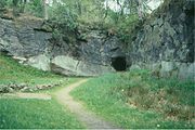
Interest in the area took off with vigour in the mid-19th century with the first real efforts made to quantify the strata of the country using the new mapping methods that geologists like William Smith
had pioneered. The economical value of the area in those times lead to a detailed examination of Alderley. Boreholes starting to be used for geological logging and research whereas previously they had been used simply for wells with no real interest taken in the actual geological make up of the rock below. In 1894, a borehole was sunk to 280 ft below surface and the strata recorded in a scientific manner. This borehole, the Isaac Massey (NGR SK 84237819) was the first serious attempt to understand the geology of the area. The area has since been subject of much more detailed research and still provides many clues to basin formation and mineralization processes. The original borehole was crude by today’s standards but it gave an overview of the strata below the Alderley area.
Now the Wilmslow Formation, (part of the Sherwood Sandstone Group), the lower Triassic was previously a threefold division, the Lower Mottled Sandstone, The Pebble Beds and the Upper Mottled Sandstone, (only the later is seen at Alderley) which merged into the Conglomerates of the upper Triassic. The Upper Mottled Sandstone now the lower Wilmslow Member is a medium to coarse-grained friable false-bedded sandstone with abrupt colour changes from bright red to white. It is composed mainly of rounded grains but sub-angular grains also occur. Normally the rock lacks coherence and weathers into sand down to 6 m and even unweathered rock can be crushed to sand easily. However near faults, ghost crystals of barites make the sandstone harder and resistant.
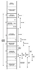
 The lower sandstone (Upper Mottled Sandstone) has a full thickness of 305 m generally a reddy brown colour with some white patches, which give it its name, these patches are often associated with organic nuclei. The sandstone has two distinct types, a bright dark red known as the Moulding Sand and mottled paler sandstone. The Moulding Sand
is so called after its use in the foundry industry for making the casting moulds. Resting on top is a conglomerate, which attains thickness of 30 m; it is the Engine Vein Conglomerate. These conglomerates are made up of angular grained sands which were laid down in cyclic sequences. This sequence is an upward fining sequence of three or four cycles.
 Three other main beds are seen at Alderley Edge. The first is friable mottled sandstone similar to the Upper Mottled Sandstone, the Beacon Lodge Sandstone which attains a thickness of 12 m and can be seen at Beacon Lodge resting above the conglomerates. The second is a conglomerate which overlies the Brynlow and is seen by the site of the old mines and is thus called the West Mine Conglomerate. There are ten upward fining cycles in this rock and it has a thickness of 40 m. The third rock is creamy white sandstone, which lacks the pebbly beds and is upward fining; it overlies the West Mine Conglomerate and is seen in outcrops at Brynlow. This is the Wood Mine Sandstone it has a thickness of 16 m. Two other minor beds are seen to the southeast of these areas a single cycle conglomerate/sandstone/marl of 9 m thickness known as the Brynlow conglomerate and a final bed that overlies the Brynlow Conglomerate and is named the Nether Alderley Sandstone. On top of the Nether Alderley Sandstone lie the Mercia Mudstones which attain a thickness of 300 m, but these are only seen on the lower plains, it is in these beds that the halite
lies.
Mottling in the red blocky mudstone is of two main types,
The ferruginous colour pigmenting is finely disseminated over the surface of individual grains and accounts for a very small percentage of the rock. It is thought that where the rock is grey or grey green either from primary or secondary causes, the oxide has been chemically removed during deposition and thus unmasking the true colour of the minerals in the sediment. The active principle is still unknown.
 The majority of the lower Triassic clastic sediments originated from a Variscan source area in northern France with minor local input. Some Alderley Edge conglomerates, consist of material originating from the Pennine block to the east. Breccias with clasts of local origin, are well developed on the edges of the basin and are interpreted as gravel fans at the mouths of wadis emerging from mountainous areas bordering the depositional basin. Others show long distance river transport by a powerful river system originating in the Amorican Massif. The basal conglomerates are made up of hard sandstone which contains angular grains. At Alderley Edge the junction is quite sharp it could be regarded as an unconformity. However interdigitation is found as if to testify against an unconformity. Mappable beds showing all the characteristics of the Upper Mottled Sandstone are found between the two basal beds of the conglomerates.
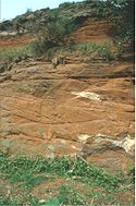
The conglomerate is typically a medium to fine grained brown to buff sandstone consisting of angular to sub angular grains with scattered flakes of mica; it makes a good building stone. Conglomerates occur in the basal part of the sequence and shale
bands that are micaceous occur in the highest beds. Viewed regionally the conglomerates appear to be impressistent. Near the southern end of the district where the ground is not covered by drift three conglomerates can be mapped. The bottom and most important is mostly pebbles - quartz
and quartzites with occasional grits and rarely some igneous. These are set in a medium to coarse grained sand matrix. the pebbles can be up to 100 mm long.
The upper parts of the district is characterised by massive posts of medium to fine sandstone up to 6 m thick separated by chocolate coloured shales which are micaceous. The pots are well bedded and often quarried for building only occasionally are they false bedded.
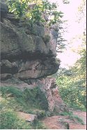
The basal conglomerate is cut into sections by the faults and can be traced in a general eastwards direction from the village to the hill top 3 km away. It is about 20 m thick and broken into crags along the upper part of the edge. It dips west - southwest at an angle of 8° - 14°.
are less common but they are evidence of deposition in shallow water. Pitting sometimes found has been linked to rain pitting but may have occurred during the de-gassing of the marls during drying out. The banded strata which may be red or grey pass up into blocky unstratified mudstones (broken up and allowed to resettle before consolidation).
Crustal extension controls the tectonic accommodation space available for sediments in rift settings and may be defined by the structural and depositional geometry of sedimentary successions observed on seismic data and the rate of subsidence through time as represented by the accommodation of sediment. The characteristic features of each are dependent on three variables: the time taken for deposition; the interplay between tectonics and eustasy and the lithology (thus facies) of the succession observed. The Sherwood Sandstone Group has been considered to represent a syn-rift phase of fluvial deposition throughout Europe, with the overlying Mercia Mudstone Group interpreted as the succeeding phase of deposition in an evaporitic seaway during post-rift thermal subsidence
. More recently, however, there has been the recognition that it is the Mercia Mudstone Group which is seen to thicken markedly into faults imaged on seismic data rather than the Sherwood Sandstone Group. This work demonstrates the Mercia Mudstone Group to be a syn-rift phase of deposition, with the fine grained nature of the sedimentary record at this time controlled by the prevailing arid climate. Such conditions were not conducive to the large-scale and rapid movement of sediments from the hinterlands raised by relative footwall uplift, thus the sediments are fine grained. The minor thickening of the Sherwood Sandstone Group into faults is interpreted to be a combination of minor extension in the early Triassic superimposed on thermal subsidence inherited from the important regional phase of extension in the early Permian. Analysis of the timing of fault growth indicates a larger proportion of fault-controlled, synsedimentary movement occurred during the mid-to-late Triassic (Mercia Mudstones) rather than the early Triassic (Sherwood).
The movements (WEM – Red Rock Fault) which in late Carboniferous times initiated the Rossendale Anticline and the Pennine uplift were repeated later probably during the Alpine of Tertiary
age, but the major fold of this date resulted in the Cheshire Basin as it is today, in which the Permo-Trias is preserved. The major faults at Alderley are almost certainly of Tertiary age, their formation following closely the folding episode. These main faults are normal.
The two large faults in the area are the Alderley and Kirkleyditch, which bound the area of interest.
The Red Sand (moulding sand) seen at Alderley Edge was used extensively for the purpose of constructing the moulds for the foundries in nearby Macclesfield during the late 19C and early 20C.
A few kilometres to the west and further over towards the Triassic outcrops of the Wirral
, where conditions were drier, footprints and track ways of insects and small vertebrates, including Rhynchosauroides and Chirotherium
, have been identified.
Alderley Edge
Alderley Edge is a village and civil parish within the unitary authority of Cheshire East and the ceremonial county of Cheshire, England. According to the 2001 census the parish had a population of 4,409....
in Cheshire
Cheshire
Cheshire is a ceremonial county in North West England. Cheshire's county town is the city of Chester, although its largest town is Warrington. Other major towns include Widnes, Congleton, Crewe, Ellesmere Port, Runcorn, Macclesfield, Winsford, Northwich, and Wilmslow...
is one of the classic locations for the study of Triassic
Triassic
The Triassic is a geologic period and system that extends from about 250 to 200 Mya . As the first period of the Mesozoic Era, the Triassic follows the Permian and is followed by the Jurassic. Both the start and end of the Triassic are marked by major extinction events...
sandstones in the United Kingdom
United Kingdom
The United Kingdom of Great Britain and Northern IrelandIn the United Kingdom and Dependencies, other languages have been officially recognised as legitimate autochthonous languages under the European Charter for Regional or Minority Languages...
. Numerous scientists from the early 19th century up to the present day have studied the area and it is a popular field site for universities around the UK. As time progresses, new theories are developed and new hypotheses are tested as to the origin of the sandstones. The information presented here provides the history and current (as of 2006) thoughts on the geological evolution of the sandstones at Alderley Edge.
Nomenclature
Bunter (geology)
Bunter beds are sandstone deposits containing rounded pebbles, such as can notably be found in Warwickshire, Cheshire, Staffordshire, Nottinghamshire, Yorkshire, Devon and Dorset in England...
’ and ‘Keuper
Keuper
The Keuper is a lithostratigraphic unit in the subsurface of large parts of west and central Europe. The Keuper consists of dolostone, shales or claystones and evaporites that were deposited during the Middle and Late Triassic epochs...
’ have now been abandoned, and the formations now recognized in the UK Triassic sequence
Sequence (geology)
A sequence in geology refers to a sequence of geological events, processes, or rocks, arranged in chronological order.A rock stratigraphical sequence is a geographical, or lithostratigraphic, discrete unit greater than a group or supergroup rank, and traceable over large areas of a continent...
s, constitute three major lithostratigraphical
Stratigraphy
Stratigraphy, a branch of geology, studies rock layers and layering . It is primarily used in the study of sedimentary and layered volcanic rocks....
units,
- the Sherwood Sandstone Group (arenaceousAreniteArenite is a sedimentary clastic rock with sand grain size between 0.0625 mm and 2 mm and contain less than 15% matrix. The related adjective is arenaceous...
siliciclasticSiliciclasticSiliciclastic rocks are clastic noncarbonate sedimentary rocks that are almost exclusively silica-bearing, either as forms of quartz or other silicate minerals. All siliciclastic rocks are formed by inorganic processes, or deposited through some mechanical process, such as stream deposits that are...
) (equivalent to the Bunter and lower Keuper) - the Mercia Mudstone GroupMercia Mudstone GroupThe Mercia Mudstone Group is a sequence of sedimentary rocks which occurs widely in the United Kingdom, consisting of beds of various mudstones, siltstones and sandstones....
(argillaceousArgillaceous mineralsArgillaceous minerals may appear silvery upon optical reflection and are minerals containing substantial amounts of clay-like components . Argillaceous components are fine-grained aluminosilicates, and more particularly clay minerals such as kaolinite, montmorillonite-smectite, illite, and...
, haliticHaliteHalite , commonly known as rock salt, is the mineral form of sodium chloride . Halite forms isometric crystals. The mineral is typically colorless or white, but may also be light blue, dark blue, purple, pink, red, orange, yellow or gray depending on the amount and type of impurities...
) (equivalent to the Keuper Marl) - the Penarth Group (not seen at Alderley).
For this reason, in places, the older names with appropriate cross references are used, in order to maintain an understanding of earlier work.
For a description of some of the other terms used see Geological unit
History
The geology of Alderley Edge has fascinated people from all walks of life, scientists, miners and tourists for hundreds of years. Bakewell describes it thus:"The hill is evidently of alluvial formation, being composed chiefly of gravel and soft white and reddish sandstone
Sandstone
Sandstone is a sedimentary rock composed mainly of sand-sized minerals or rock grains.Most sandstone is composed of quartz and/or feldspar because these are the most common minerals in the Earth's crust. Like sand, sandstone may be any colour, but the most common colours are tan, brown, yellow,...
, - the white is intermixed with rounded quartz
Quartz
Quartz is the second-most-abundant mineral in the Earth's continental crust, after feldspar. It is made up of a continuous framework of SiO4 silicon–oxygen tetrahedra, with each oxygen being shared between two tetrahedra, giving an overall formula SiO2. There are many different varieties of quartz,...
pebbles, the red with particle of mica
Mica
The mica group of sheet silicate minerals includes several closely related materials having highly perfect basal cleavage. All are monoclinic, with a tendency towards pseudohexagonal crystals, and are similar in chemical composition...
. In some parts the red and white sandstone assume a nearly stratified
Stratigraphy
Stratigraphy, a branch of geology, studies rock layers and layering . It is primarily used in the study of sedimentary and layered volcanic rocks....
appearance, in others the red stone intersects the white in very thin seams, branching in various directions. In the white sandstone are found various ores of lead as small portions of galena
Galena
Galena is the natural mineral form of lead sulfide. It is the most important lead ore mineral.Galena is one of the most abundant and widely distributed sulfide minerals. It crystallizes in the cubic crystal system often showing octahedral forms...
and in the same granular state intermixed with sandstone. In other places particles of blue and brown were collected in nodules
Nodule (geology)
A nodule in petrology or mineralogy is a secondary structure, generally spherical or irregularly rounded in shape. Nodules are typically solid replacement bodies of chert or iron oxides formed during diagenesis of a sedimentary rock...
of various sizes and imbedded along with pebbles in the sand rock like currants in a pudding".
A few years later, Ormerod in his book the ‘History of Cheshire’
describes it as follows:
"Alderley Edge is an abrupt and elevated ridge, formerly the site of a beacon
Beacon
A beacon is an intentionally conspicuous device designed to attract attention to a specific location.Beacons can also be combined with semaphoric or other indicators to provide important information, such as the status of an airport, by the colour and rotational pattern of its airport beacon, or of...
, which bears the appearance of having been detached by some great convulsion of nature from the range of the Macclesfield
Macclesfield
Macclesfield is a market town within the unitary authority of Cheshire East, the county palatine of Chester, also known as the ceremonial county of Cheshire, England. The population of the Macclesfield urban sub-area at the time of the 2001 census was 50,688...
hills. Near the summit cobalt
Cobalt
Cobalt is a chemical element with symbol Co and atomic number 27. It is found naturally only in chemically combined form. The free element, produced by reductive smelting, is a hard, lustrous, silver-gray metal....
ore, lead
Lead
Lead is a main-group element in the carbon group with the symbol Pb and atomic number 82. Lead is a soft, malleable poor metal. It is also counted as one of the heavy metals. Metallic lead has a bluish-white color after being freshly cut, but it soon tarnishes to a dull grayish color when exposed...
and copper
Copper
Copper is a chemical element with the symbol Cu and atomic number 29. It is a ductile metal with very high thermal and electrical conductivity. Pure copper is soft and malleable; an exposed surface has a reddish-orange tarnish...
have been got in small quantities. The sides are varied with cultivated land, wood and rock; and the entire mass presents a striking object to all the surrounding district over which it commands a most extensive prospect".
Regional Setting
The CheshireCheshire
Cheshire is a ceremonial county in North West England. Cheshire's county town is the city of Chester, although its largest town is Warrington. Other major towns include Widnes, Congleton, Crewe, Ellesmere Port, Runcorn, Macclesfield, Winsford, Northwich, and Wilmslow...
Basin is today one of the classic onshore localities in the UK for the study of Triassic
Triassic
The Triassic is a geologic period and system that extends from about 250 to 200 Mya . As the first period of the Mesozoic Era, the Triassic follows the Permian and is followed by the Jurassic. Both the start and end of the Triassic are marked by major extinction events...
red-bed
Red beds
Red beds are sedimentary rocks, which typically consist of sandstone, siltstone, and shale that are predominantly red in color due to the presence of ferric oxides. Frequently, these red-colored sedimentary strata locally contain thin beds of conglomerate, marl, limestone, or some combination of...
fluvial
Fluvial
Fluvial is used in geography and Earth science to refer to the processes associated with rivers and streams and the deposits and landforms created by them...
and aeolian sandstone sequences, and provides important insights to the nature and evolution of deformation in continental clastic natural gas
Natural gas
Natural gas is a naturally occurring gas mixture consisting primarily of methane, typically with 0–20% higher hydrocarbons . It is found associated with other hydrocarbon fuel, in coal beds, as methane clathrates, and is an important fuel source and a major feedstock for fertilizers.Most natural...
and petroleum reservoirs
Oil exploration
Hydrocarbon exploration is the search by petroleum geologists and geophysicists for hydrocarbon deposits beneath the Earth's surface, such as oil and natural gas...
, such as those of the Rotliegend
Rotliegend
The Rotliegend or Rotliegendes is a lithostratigraphic unit of Cisuralian age that is found in the subsurface of large areas in western and central Europe. The Rotliegend mainly consists of sandstone layers...
in the Southern North Sea
North Sea
In the southwest, beyond the Straits of Dover, the North Sea becomes the English Channel connecting to the Atlantic Ocean. In the east, it connects to the Baltic Sea via the Skagerrak and Kattegat, narrow straits that separate Denmark from Norway and Sweden respectively...
Gas Basin and of the Sherwood Sandstone
Sandstone
Sandstone is a sedimentary rock composed mainly of sand-sized minerals or rock grains.Most sandstone is composed of quartz and/or feldspar because these are the most common minerals in the Earth's crust. Like sand, sandstone may be any colour, but the most common colours are tan, brown, yellow,...
in the adjacent East Irish Sea
Irish Sea
The Irish Sea separates the islands of Ireland and Great Britain. It is connected to the Celtic Sea in the south by St George's Channel, and to the Atlantic Ocean in the north by the North Channel. Anglesey is the largest island within the Irish Sea, followed by the Isle of Man...
Basin. Analogues for cemented cataclastic faults, which can compartmentalise reservoirs, are well displayed by the arrays of deformation bands within the Alderley outcrop
Outcrop
An outcrop is a visible exposure of bedrock or ancient superficial deposits on the surface of the Earth. -Features:Outcrops do not cover the majority of the Earth's land surface because in most places the bedrock or superficial deposits are covered by a mantle of soil and vegetation and cannot be...
s.
The Cheshire Basin
Regionally, the Cheshire basin is a deep fault bounded half-graben containing up to 4.5 km of Permo-Triassic sediments. The basin is approximately 100 km North - South and up to 50 km east-west and is bounded on the eastern margin by the Wem-Red Rock fault system. Syn-depositional movements on the Wem-Red Rock fault system during the Triassic had a significant effect on the subsidence and sedimentationSedimentation
Sedimentation is the tendency for particles in suspension to settle out of the fluid in which they are entrained, and come to rest against a barrier. This is due to their motion through the fluid in response to the forces acting on them: these forces can be due to gravity, centrifugal acceleration...
rates within the basin. Crustal uplift and erosion during the Tertiary were a direct result of reactivation of these earlier faults. Today active movement of the Wem-Red Rock fault system causes minor earthquakes across an area from North Wales
North Wales
North Wales is the northernmost unofficial region of Wales. It is bordered to the south by the counties of Ceredigion and Powys in Mid Wales and to the east by the counties of Shropshire in the West Midlands and Cheshire in North West England...
to Lancaster
Lancaster, Lancashire
Lancaster is the county town of Lancashire, England. It is situated on the River Lune and has a population of 45,952. Lancaster is a constituent settlement of the wider City of Lancaster, local government district which has a population of 133,914 and encompasses several outlying towns, including...
. An interactive earthquake map can be found at the British Geological Survey Site.
The sediment infill of the basin is of Permian
Permian
The PermianThe term "Permian" was introduced into geology in 1841 by Sir Sir R. I. Murchison, president of the Geological Society of London, who identified typical strata in extensive Russian explorations undertaken with Edouard de Verneuil; Murchison asserted in 1841 that he named his "Permian...
to lower Jurassic
Jurassic
The Jurassic is a geologic period and system that extends from about Mya to Mya, that is, from the end of the Triassic to the beginning of the Cretaceous. The Jurassic constitutes the middle period of the Mesozoic era, also known as the age of reptiles. The start of the period is marked by...
age and is up to 4.5 km thick in the south-east suggesting that greater and later subsidence occurred in the basin than in any other British Permo Triassic basin.
An extensional regime in the early Permian is believed to have initiated major faults which were to form the basin margins, the most notable of these is the Wem-Red Rock fault system in the east. Subsidence related to this fault movement heralded the beginning of basin formation and of infilling by early Permian sediments, the distribution of which is thought to have been controlled by the NE-SW faults parallel to the Wem-Red Rock faults. Basal Permian breccias deposited as alluvial fan
Alluvial fan
An alluvial fan is a fan-shaped deposit formed where a fast flowing stream flattens, slows, and spreads typically at the exit of a canyon onto a flatter plain. A convergence of neighboring alluvial fans into a single apron of deposits against a slope is called a bajada, or compound alluvial...
s lie unconformably. Manchester
Manchester
Manchester is a city and metropolitan borough in Greater Manchester, England. According to the Office for National Statistics, the 2010 mid-year population estimate for Manchester was 498,800. Manchester lies within one of the UK's largest metropolitan areas, the metropolitan county of Greater...
Marl
Marl
Marl or marlstone is a calcium carbonate or lime-rich mud or mudstone which contains variable amounts of clays and aragonite. Marl was originally an old term loosely applied to a variety of materials, most of which occur as loose, earthy deposits consisting chiefly of an intimate mixture of clay...
s represent a brief transgression into marine
Marine (ocean)
Marine is an umbrella term. As an adjective it is usually applicable to things relating to the sea or ocean, such as marine biology, marine ecology and marine geology...
conditions in the mid Permian, their distribution and increased thickness of Permian sediments in the north indicates a depositional centre towards the north or northeast of the basin at this time. Basin subsidence was initiated in the early Triassic when subsidence related to movements on the faults on the eastern margins of the Worcester
Worcester
The City of Worcester, commonly known as Worcester, , is a city and county town of Worcestershire in the West Midlands of England. Worcester is situated some southwest of Birmingham and north of Gloucester, and has an approximate population of 94,000 people. The River Severn runs through the...
and Cheshire basins led to a connection between them and to the evolution of a drainage system with rivers sourced in the Variscan foreland.
The aeolian-fluvial
Fluvial
Fluvial is used in geography and Earth science to refer to the processes associated with rivers and streams and the deposits and landforms created by them...
sandstone formation represents the uppermost unit of accumulation within the Sherwood Sandstone Group of the Cheshire Basin (Mid-Triassic). Three distinct members (Thurstaston
Thurstaston
Thurstaston is a village on the Wirral Peninsula, England. It is part of the West Kirby & Thurstaston Ward of the Metropolitan Borough of Wirral...
, Delamere
Delamere, Cheshire
thumb|right|200px|Map of civil parish of Delamere within the former borough of Vale RoyalDelamere is a civil parish and village in Cheshire. It is situated approximately 7 miles to the west of Northwich, within the unitary authority of Cheshire West and Chester.The village is well-known for the...
and Frodsham
Frodsham
Frodsham is a market town and civil parish in the unitary authority of Cheshire West and Chester and the ceremonial county of Cheshire, England. Its population is 8,982. It is approximately south of Runcorn, 16 miles south of Liverpool, and approximately south-west of Manchester...
) are recognised on the basis of lithofacies
Lithofacies
Lithofacies may refer to:* A mappable subdivision of a designated stratigraphic unit, distinguished from adjacent subdivisions on the basis of lithology; a facies characterized by particular lithologic features....
type. Stratigraphic correlation of the formation within the northern and central parts of the Cheshire Basin has been undertaken using a combination of outcrop, core, well-log and historical data to provide regional-scale, district-scale and high-resolution local-scale overviews of the stratigraphic architecture. At the regional scale a 30-km-long correlation panel has been constructed using data from 17 key localities along a transect from Runcorn
Runcorn
Runcorn is an industrial town and cargo port within the borough of Halton in the ceremonial county of Cheshire, England. In 2009, its population was estimated to be 61,500. The town is on the southern bank of the River Mersey where the estuary narrows to form Runcorn Gap. Directly to the north...
to Delamere Forest
Delamere Forest
Delamere Forest or Delamere Forest Park is a wood in the Cheshire West and Chester area of Cheshire, England, near the town of Frodsham. It includes of mixed deciduous and evergreen woodland, centred at around , making it the largest area of woodland in Cheshire...
at the southern end of the basin. Variations in the thickness of the formation between several fault-bounded blocks may reflect syn-tectonic sedimentary evolution of the succession. Cycles of fluvial-to-aeolian sedimentation, possibly driven by periodic climatic fluctuation are easily recognised within individual fault blocks but can't be traced continuously across the entire region. A 10-km-long correlation of the Delamere Member within the Runcorn-Frodsham (15 km to the west of Alderley) member shows a laterally extensive but thin (1 to 7 m thick) series of mudstone bands with associated aeolian cross-bedded sets that punctuate the predominantly fluvial strata
Stratum
In geology and related fields, a stratum is a layer of sedimentary rock or soil with internally consistent characteristics that distinguish it from other layers...
. These are interpreted as the uppermost part of a drying-upward cycle that represents the fluvial system giving way to aeolian activity prior to the onset of renewed fluvial flash flood activity.
The detailed stratigraphy
Stratigraphy
Stratigraphy, a branch of geology, studies rock layers and layering . It is primarily used in the study of sedimentary and layered volcanic rocks....
of a 30-metre-thick interval of the central part of the Delamere Member has been examined in a series of quarries at Runcorn Hill. A 400-metre-long quantitative panel was examined and it documents the stratigraphy of a mixed fluvial and aeolian succession. Here, the aeolian is interpreted as the deposits of sinuous-crested transverse barchanoid dunes that exhibited obliquely migrating scour-pits on their lee (downwind) slopes.
Upward fining facies successions within the Members are characterised by planar laminated, ripple-bedded and cross-bedded sandstones with abundant intraformational rip-up clasts, exotic clasts and water escape structures. These successions are interpreted to represent waning flood conditions in an ephemeral fluvial system conditioned by semi-arid
Semi-arid
A semi-arid climate or steppe climate describes climatic regions that receive precipitation below potential evapotranspiration, but not extremely...
climatic conditions. In the Runcorn district of the basin one 20-m-thick fining-up succession culminates in a series of thin (5–20 cm) red sandy-mudstone
Mudstone
Mudstone is a fine grained sedimentary rock whose original constituents were clays or muds. Grain size is up to 0.0625 mm with individual grains too small to be distinguished without a microscope. With increased pressure over time the platey clay minerals may become aligned, with the...
beds that are interbedded with sets of cross-bedded soft sandstones characterised by grain flow and wind-ripple
Ripple marks
In geology, ripple marks are sedimentary structures and indicate agitation by water or wind.- Defining ripple cross-laminae and asymmetric ripples :...
laminae indicative of aeolian dune accumulation. The sandy-mudstone beds including the Alderley beds are characterised by wavy laminae, desiccation cracks, mud flakes, raindrop imprints, loads and flutes.
This sedimentological evidence, together with the association of the mudstone beds with the aeolian dune units favours an interpretation of fluvially flooded interdune ponds that were periodically subject to desiccation and re-flooding. In places the mudstone beds pass laterally into horizontally laminated wind-ripple beds that indicate a transition from wet, through damp to dry interdune conditions. These interdune strata exhibit a ‘feathered’ relationship with the toe-sets of the overlying aeolian dune units, signifying dune migration that was contemporaneous with damp/wet surface conditions within the adjacent interdunes. This indicates that the aeolian dune-interdune system underwent ‘wet-climbing’ whereby accumulation of both dune and interdune strata continued uninterrupted through minor flooding events.
Red Bed Deposits
The Alderley sandstones are described as classic Red Bed deposits. 'Red Beds’ are a distinctive sedimentary facies traditionally associated with non-marine depositional environments such as alluvial floodplainFloodplain
A floodplain, or flood plain, is a flat or nearly flat land adjacent a stream or river that stretches from the banks of its channel to the base of the enclosing valley walls and experiences flooding during periods of high discharge...
s and arid desert
Desert
A desert is a landscape or region that receives an extremely low amount of precipitation, less than enough to support growth of most plants. Most deserts have an average annual precipitation of less than...
s. They range in age from Early Proterozoic
Proterozoic
The Proterozoic is a geological eon representing a period before the first abundant complex life on Earth. The name Proterozoic comes from the Greek "earlier life"...
to Cenozoic
Cenozoic
The Cenozoic era is the current and most recent of the three Phanerozoic geological eras and covers the period from 65.5 mya to the present. The era began in the wake of the Cretaceous–Tertiary extinction event at the end of the Cretaceous that saw the demise of the last non-avian dinosaurs and...
and are regarded as geochemical indicators of oxidizing conditions. In the past there has been much debate whether these continental red beds are primary (formed during deposition) or diagenetic (post-depositional) in origin.
Red Beds are coloured by finely disseminated ferric oxides, usually in the form of hematite
Hematite
Hematite, also spelled as haematite, is the mineral form of iron oxide , one of several iron oxides. Hematite crystallizes in the rhombohedral system, and it has the same crystal structure as ilmenite and corundum...
(Fe2 O3) although a range of other iron oxyhydroxide minerals are normally present. Oxidation-reduction
Redox
Redox reactions describe all chemical reactions in which atoms have their oxidation state changed....
(Eh
Eh
Eh is a spoken interjection in English, Armenian, Japanese, French, Italian, Greek, Spanish, Portuguese and Catalan that is similar in meaning to "Excuse me," "Please repeat that" or "huh?" It is also commonly used as a method for inciting an answer, as in "It's nice here, eh?" It is occasionally...
) and pH
PH
In chemistry, pH is a measure of the acidity or basicity of an aqueous solution. Pure water is said to be neutral, with a pH close to 7.0 at . Solutions with a pH less than 7 are said to be acidic and solutions with a pH greater than 7 are basic or alkaline...
control hematite
Hematite
Hematite, also spelled as haematite, is the mineral form of iron oxide , one of several iron oxides. Hematite crystallizes in the rhombohedral system, and it has the same crystal structure as ilmenite and corundum...
formation and the observed minor colour variations often seen in red beds. In general, the colour variations relate to changes in pore water chemistry resulting from fluctuations in the depositional or early diagenetic environment. In particular, intercalated marine units are normally non-red because the high levels of organic productivity produce reducing conditions below the sediment-water interface
Sediment-water interface
In oceanography and limnology, the sediment-water interface is the boundary between bed sediment and the overlying water column. The topography of this interface is often dynamic, as it is affected by physical processes and biological processes ....
.
Triassic in northern England
The Triassic succession of Great Britain is divided into a number of stratigraphical units that are generally hard to assign to divisions of the Lower, Middle, and Upper Triassic.The upper boundary of the Triassic is defined by the base of the Jurassic System, which is internationally recognized as being at the base of the planorbis
Planorbis
Planorbis is a genus of freshwater air-breathing snails, aquatic pulmonate gastropod mollusks in the family Planorbidae, the ram's horn snails, or planorbids. All species in this genus have sinistral or left-coiling shells.- Description :...
subzone of the planorbis Ammonite
Ammonite
Ammonite, as a zoological or paleontological term, refers to any member of the Ammonoidea an extinct subclass within the Molluscan class Cephalopoda which are more closely related to living coleoids Ammonite, as a zoological or paleontological term, refers to any member of the Ammonoidea an extinct...
Zone of the Hettangian Stage.
The Triassic Period (251Ma – 205Ma) is part of the Mesozoic Era (251Ma – 65Ma) and is so called from its former threefold division in its type locality in Germany. The divisions have been revised in nomenclature so that they do not correspond with most of the older literature. The onshore Triassic in Britain differs from that in the southern North Sea, Germany and other parts of northern Europe, in not being the classic tripartite lithostratigraphic subdivision; The Triassic deposits of Germany form three series. In the Bunter
Bunter (geology)
Bunter beds are sandstone deposits containing rounded pebbles, such as can notably be found in Warwickshire, Cheshire, Staffordshire, Nottinghamshire, Yorkshire, Devon and Dorset in England...
(meaning 'brightly-coloured') series, the land was emergent and red sandstone and sandy shales, with some salt and gypsum, were deposited. The Muschelkalk
Muschelkalk
The Muschelkalk is a sequence of sedimentary rock strata in the geology of central and western Europe. It has a Middle Triassic age and forms the middle part of the Germanic Trias, that further consists of the Buntsandstein and Keuper...
series saw the transgression of the land by the sea and the deposition of marine shale and limestone; the Keuper
Keuper
The Keuper is a lithostratigraphic unit in the subsurface of large parts of west and central Europe. The Keuper consists of dolostone, shales or claystones and evaporites that were deposited during the Middle and Late Triassic epochs...
series saw the land again emergent and shale, sandstone, and gypsum being formed. Instead, the British Triassic is divided into the Sherwood Sandstone Group, the overlying Mercia Mudstone Group (previously described by their quasi Germanic names, the Bunter and the Keuper) and the Penarth Group these together attain a maximum thickness of ca. 3.5 km in the Cheshire Basin.. In Britain the middle division of marine beds is largely absent, giving the original twofold division into Keuper and Bunter, which whilst recognizable as lithological
Lithology
The lithology of a rock unit is a description of its physical characteristics visible at outcrop, in hand or core samples or with low magnification microscopy, such as colour, texture, grain size, or composition. It may be either a detailed description of these characteristics or be a summary of...
or facies divisions, they are not equivalent to the strata in Germany
Germany
Germany , officially the Federal Republic of Germany , is a federal parliamentary republic in Europe. The country consists of 16 states while the capital and largest city is Berlin. Germany covers an area of 357,021 km2 and has a largely temperate seasonal climate...
. The absence of the middle facies, the Muschelkalk, does not mean that Muschelkalk beds of the middle Triassic are absent, but rather that the deposition was continental over this area and not marine as over northern and central Europe. Dating is therefore difficult as there are no fossils and there was no igneous activity, which could have led to the emplacement of isotope
Isotope
Isotopes are variants of atoms of a particular chemical element, which have differing numbers of neutrons. Atoms of a particular element by definition must contain the same number of protons but may have a distinct number of neutrons which differs from atom to atom, without changing the designation...
s enabling dating. Recent work has shown that the Mercia Mudstones are more complex than originally thought and there are now proposals to give new stratigraphic names to four of the formations.
Permo – Triassic
By the Triassic, the PermianPermian
The PermianThe term "Permian" was introduced into geology in 1841 by Sir Sir R. I. Murchison, president of the Geological Society of London, who identified typical strata in extensive Russian explorations undertaken with Edouard de Verneuil; Murchison asserted in 1841 that he named his "Permian...
Zechstein Sea had retreated and the climate had become a little wetter giving a gentle transition making the Permian-Triassic boundary uncertain in northern England as there are no fossil horizons or facies
Facies
In geology, facies are a body of rock with specified characteristics. Ideally, a facies is a distinctive rock unit that forms under certain conditions of sedimentation, reflecting a particular process or environment....
changes that make a definitive separation possible as there in continental Europe. The horizon however is characterised by a succession of red marls (calcareous mudstones) deposited on coastal flats, followed by the Sherwood Sandstone (formerly Bunter Sandstone). The 'British Isles' were not islands, but had an intra-continental position within Pangea. The area that now constitutes Great Britain was drifting northwards as Pangea rotated, was at a latitude of 10° - 20° north, equivalent to the latitude of the present day Sahara desert. Erosion of the then recently uplifted landmass formed Aeolian deposits in the southern and central parts of the country. This iron-rich silica sandstone was both oxidised and reworked to give it its red colouration and its name, "New Red Sandstone
New Red Sandstone
The New Red Sandstone is a chiefly British geological term for the beds of red sandstone and associated rocks laid down throughout the Permian to the beginning of the Triassic that underlie the Jurassic Lias; the term distinguishes it from the Old Red Sandstone which is largely Devonian in...
". British deposits of the era consist of these red beds, alluvial, fluvial and lake deposits, with some shallow-water marine and evaporite
Evaporite
Evaporite is a name for a water-soluble mineral sediment that result from concentration and crystallization by evaporation from an aqueous solution. There are two types of evaporate deposits, marine which can also be described as ocean deposits, and non-marine which are found in standing bodies of...
deposits. These Permo-Triassic outcrops can be seen on either side of the Pennines
Pennines
The Pennines are a low-rising mountain range, separating the North West of England from Yorkshire and the North East.Often described as the "backbone of England", they form a more-or-less continuous range stretching from the Peak District in Derbyshire, around the northern and eastern edges of...
and in Devon
Devon
Devon is a large county in southwestern England. The county is sometimes referred to as Devonshire, although the term is rarely used inside the county itself as the county has never been officially "shired", it often indicates a traditional or historical context.The county shares borders with...
. Within the main central England basin (Staffordshire
Staffordshire
Staffordshire is a landlocked county in the West Midlands region of England. For Eurostat purposes, the county is a NUTS 3 region and is one of four counties or unitary districts that comprise the "Shropshire and Staffordshire" NUTS 2 region. Part of the National Forest lies within its borders...
and Cheshire
Cheshire
Cheshire is a ceremonial county in North West England. Cheshire's county town is the city of Chester, although its largest town is Warrington. Other major towns include Widnes, Congleton, Crewe, Ellesmere Port, Runcorn, Macclesfield, Winsford, Northwich, and Wilmslow...
), the deposits are dominated by pebbly sandstones and conglomerates (Chester Pebble Beds, Wilmslow and Wildmoor Sandstones), which have been interpreted as the deposits of a fluvial system running within well-confined channels. The Sherwood Sandstone Group comprises a series of conglomerates, coarse sandstones and mudstones. The Chester pebble beds to the south of Alderley represent material deposited in alluvial fan/braided river system. The finer sediments of the Wilmslow and Helsby Sandstone to the west of Alderley represent alluvial deposits of low sinuosity
Sinuosity
Sinuosity or sinuosity index is a measure of deviation of a path between two points from the shortest possible path...
channels. The Alderley area represents the mid point between the full braided river system and the lower energy area. Minor aeolian dunes and channel infill deposits in the Wilmslow Sandstones indicate an inter channel area or seasonal drying of some of the minor river channels.
On a more global level, to the east of what is now England, the new Tethys Ocean
Tethys Ocean
The Tethys Ocean was an ocean that existed between the continents of Gondwana and Laurasia during the Mesozoic era before the opening of the Indian Ocean.-Modern theory:...
, extended south east through the Mediterranean region then east through the Middle East
Middle East
The Middle East is a region that encompasses Western Asia and Northern Africa. It is often used as a synonym for Near East, in opposition to Far East...
to the Himalayas
Himalayas
The Himalaya Range or Himalaya Mountains Sanskrit: Devanagari: हिमालय, literally "abode of snow"), usually called the Himalayas or Himalaya for short, is a mountain range in Asia, separating the Indian subcontinent from the Tibetan Plateau...
and to India
India
India , officially the Republic of India , is a country in South Asia. It is the seventh-largest country by geographical area, the second-most populous country with over 1.2 billion people, and the most populous democracy in the world...
. During the Triassic a subduction
Subduction
In geology, subduction is the process that takes place at convergent boundaries by which one tectonic plate moves under another tectonic plate, sinking into the Earth's mantle, as the plates converge. These 3D regions of mantle downwellings are known as "Subduction Zones"...
complex including an elongate volcanic arc system developed along what would become the North American east coast. North Africa
North Africa
North Africa or Northern Africa is the northernmost region of the African continent, linked by the Sahara to Sub-Saharan Africa. Geopolitically, the United Nations definition of Northern Africa includes eight countries or territories; Algeria, Egypt, Libya, Morocco, South Sudan, Sudan, Tunisia, and...
and Europe
Europe
Europe is, by convention, one of the world's seven continents. Comprising the westernmost peninsula of Eurasia, Europe is generally 'divided' from Asia to its east by the watershed divides of the Ural and Caucasus Mountains, the Ural River, the Caspian and Black Seas, and the waterways connecting...
were still attached to North America
North America
North America is a continent wholly within the Northern Hemisphere and almost wholly within the Western Hemisphere. It is also considered a northern subcontinent of the Americas...
as part of the supercontinent
Supercontinent
In geology, a supercontinent is a landmass comprising more than one continental core, or craton. The assembly of cratons and accreted terranes that form Eurasia qualifies as a supercontinent today.-History:...
, Pangaea
Pangaea
Pangaea, Pangæa, or Pangea is hypothesized as a supercontinent that existed during the Paleozoic and Mesozoic eras about 250 million years ago, before the component continents were separated into their current configuration....
.
The Lower Triassic
The Sherwood Sandstone Group can be broadly divided into an upper (previously Keuper) and a lower (previously Bunter) unit, at the level of a widely recognized intra-Sherwood Sandstone disconformity perhaps within the uppermost Lower Triassic This disconformity separates two quite distinct environmental systems. This disconformity is widely assumed to be equivalent to the Hardegsen disconformity of the central European/Southern North Sea Basin, although the age of this disconformity is not constrained as it is in Europe by biostratigraphical indicatorsBelow the intra-Sherwood Sandstone disconformity these deposits are dominated by evidence of a major braided river system, this river system responsible for transporting the sand and gravel to the Alderley area was named by Wills (1970) the Budleighensis River, after Budleigh Salterton
Budleigh Salterton
Budleigh Salterton is a small town on the south coast of Devon, England 15 miles south of Exeter. It is situated within an Area of Outstanding Natural Beauty designated East Devon AONB.- Features :...
in Devon, where its existence was first established.
Within the western onshore basins there are several clues indicating that the river flowed in a northerly direction. Within the Alderley conglomerates, there are well rounded liver coloured quartzite pebbles from a source found only in the Variscan mountains of Brittany, France. Some pebbles contain microfossils of marine animals (Lingula lesueuri and Orthis budleighensis) which can be traced to the same source area in the Armorican Massif
Armorican Massif
The Armorican Massif is a geologic massif that covers a large area in the northwest of France, including Brittany, the western part of Normandy and the Pays de la Loire. Its name comes from the old Armorica, a Gaul area between the Loire and the Seine rivers...
.
Pebbles of Carboniferous limestone
Carboniferous limestone
Carboniferous Limestone is a term used to describe a variety of different types of limestone occurring widely across Great Britain and Ireland which were deposited during the Dinantian epoch of the Carboniferous period. They were formed between 363 and 325 million years ago...
and reworked earlier Triassic sandstones indicate their source as being from the South Derbyshire
Derbyshire
Derbyshire is a county in the East Midlands of England. A substantial portion of the Peak District National Park lies within Derbyshire. The northern part of Derbyshire overlaps with the Pennines, a famous chain of hills and mountains. The county contains within its boundary of approx...
area and the Clent
Clent
Clent is a village and civil parish in the Bromsgrove District of Worcestershire, England, southwest of Birmingham and close to the edge of the West Midlands conurbation. At the 2001 census it had a population of 2,600...
Area south of Birmingham
Birmingham
Birmingham is a city and metropolitan borough in the West Midlands of England. It is the most populous British city outside the capital London, with a population of 1,036,900 , and lies at the heart of the West Midlands conurbation, the second most populous urban area in the United Kingdom with a...
respectively. There is further evidence from the distribution of the pebbles themselves, the average size of the stones on the southern margin of the basin is noticeably larger than that to the north, which is consistent with a flow of water from the south.
The river system flowed northwards through the Wessex
Wessex
The Kingdom of Wessex or Kingdom of the West Saxons was an Anglo-Saxon kingdom of the West Saxons, in South West England, from the 6th century, until the emergence of a united English state in the 10th century, under the Wessex dynasty. It was to be an earldom after Canute the Great's conquest...
Basin, the Worcester Basin, the various midland basins and on into the East Irish Sea
Irish Sea
The Irish Sea separates the islands of Ireland and Great Britain. It is connected to the Celtic Sea in the south by St George's Channel, and to the Atlantic Ocean in the north by the North Channel. Anglesey is the largest island within the Irish Sea, followed by the Isle of Man...
Basin just to the north west of the Alderley area. A second branch probably flowed eastwards into the southern North Sea
North Sea
In the southwest, beyond the Straits of Dover, the North Sea becomes the English Channel connecting to the Atlantic Ocean. In the east, it connects to the Baltic Sea via the Skagerrak and Kattegat, narrow straits that separate Denmark from Norway and Sweden respectively...
. This Budleighensis river system is evident by a series of sandstones with generally northwards directed palaeocurrents, which can be traced along a south to north line along the central parts of Britain.
Indications are that it probably had large seasonal changes in discharge, evident by cross-bedded
Cross-bedding
In geology, the sedimentary structures known as cross-bedding refer to horizontal units that are internally composed of inclined layers. This is a case in geology in which the original depositional layering is tilted, and the tilting is not a result of post-depositional deformation...
sandstones deposited at stages of lower flow, although whilst the flow was seasonal, it is perhaps doubtful if this system was ephemeral in nature for there is relatively little evidence of any large scale aeolian sandstones in the basinal settings of the Midlands
English Midlands
The Midlands, or the English Midlands, is the traditional name for the area comprising central England that broadly corresponds to the early medieval Kingdom of Mercia. It borders Southern England, Northern England, East Anglia and Wales. Its largest city is Birmingham, and it was an important...
. It is clear that more locally sourced material such as carboniferous limestone and reworked earlier Triassic sandstone from the Clent area just south of Birmingham were also important components of the river systems as they flowed northwards giving some indication of the relief of the basin margins.
Towards the end of the Triassic, the sea level once again rose and periodic flooding caused by high spring tides and strong on-shore winds led to the formation of on shore saline
Saline water
Saline water is a general term for water that contains a significant concentration of dissolved salts . The concentration is usually expressed in parts per million of salt....
lagoon
Lagoon
A lagoon is a body of shallow sea water or brackish water separated from the sea by some form of barrier. The EU's habitat directive defines lagoons as "expanses of shallow coastal salt water, of varying salinity or water volume, wholly or partially separated from the sea by sand banks or shingle,...
s or sabkha
Sabkha
Sabkha is a transliteration of the Arabic word for a salt flat. Sabkhas are supratidal, forming along arid coastlines and are characterized by evaporite-carbonate deposits with some siliciclastics. Sabkhas form subaerial, prograding and shoaling-upward sequences that have an average thickness of a...
environments. (A sabkha is a wide area of coastal flats bordering the sea, the name coming from certain coastal areas of Arabia). Intense evaporation from these lagoons resulted in the precipitation of a carbonate-sulphate complex and the thick halite
Halite
Halite , commonly known as rock salt, is the mineral form of sodium chloride . Halite forms isometric crystals. The mineral is typically colorless or white, but may also be light blue, dark blue, purple, pink, red, orange, yellow or gray depending on the amount and type of impurities...
beds as seen to the south west of Alderley in Northwich
Northwich
Northwich is a town and civil parish in the unitary authority of Cheshire West and Chester and the ceremonial county of Cheshire, England. It lies in the heart of the Cheshire Plain, at the confluence of the rivers Weaver and Dane...
where the salt is mined commercially. It was in this type of environment that the Mercia Mudstone Group (formerly Keuper Marl) was deposited.
The sequence of formations in the Sherwood and Mercia mudstone groups in this region illustrates clearly the upward transition from continental fluvial to deltaic and littoral
Littoral
The littoral zone is that part of a sea, lake or river that is close to the shore. In coastal environments the littoral zone extends from the high water mark, which is rarely inundated, to shoreline areas that are permanently submerged. It always includes this intertidal zone and is often used to...
marine and ultimately to the hyperslaine epeiric sea environment of the Mercia Mudstone group.
The Alderley Sandstones
Interest in the area took off with vigour in the mid-19th century with the first real efforts made to quantify the strata of the country using the new mapping methods that geologists like William Smith
William Smith (geologist)
William 'Strata' Smith was an English geologist, credited with creating the first nationwide geological map. He is known as the "Father of English Geology" for collating the geological history of England and Wales into a single record, although recognition was very slow in coming...
had pioneered. The economical value of the area in those times lead to a detailed examination of Alderley. Boreholes starting to be used for geological logging and research whereas previously they had been used simply for wells with no real interest taken in the actual geological make up of the rock below. In 1894, a borehole was sunk to 280 ft below surface and the strata recorded in a scientific manner. This borehole, the Isaac Massey (NGR SK 84237819) was the first serious attempt to understand the geology of the area. The area has since been subject of much more detailed research and still provides many clues to basin formation and mineralization processes. The original borehole was crude by today’s standards but it gave an overview of the strata below the Alderley area.
Now the Wilmslow Formation, (part of the Sherwood Sandstone Group), the lower Triassic was previously a threefold division, the Lower Mottled Sandstone, The Pebble Beds and the Upper Mottled Sandstone, (only the later is seen at Alderley) which merged into the Conglomerates of the upper Triassic. The Upper Mottled Sandstone now the lower Wilmslow Member is a medium to coarse-grained friable false-bedded sandstone with abrupt colour changes from bright red to white. It is composed mainly of rounded grains but sub-angular grains also occur. Normally the rock lacks coherence and weathers into sand down to 6 m and even unweathered rock can be crushed to sand easily. However near faults, ghost crystals of barites make the sandstone harder and resistant.
Lower sandstones
Sand casting
Sand casting, also known as sand molded casting, is a metal casting process characterized by using sand as the mold material.It is relatively cheap and sufficiently refractory even for steel foundry use. A suitable bonding agent is mixed or occurs with the sand...
is so called after its use in the foundry industry for making the casting moulds. Resting on top is a conglomerate, which attains thickness of 30 m; it is the Engine Vein Conglomerate. These conglomerates are made up of angular grained sands which were laid down in cyclic sequences. This sequence is an upward fining sequence of three or four cycles.
Halite
Halite , commonly known as rock salt, is the mineral form of sodium chloride . Halite forms isometric crystals. The mineral is typically colorless or white, but may also be light blue, dark blue, purple, pink, red, orange, yellow or gray depending on the amount and type of impurities...
lies.
Mottling in the red blocky mudstone is of two main types,
- A light red or greyish green coloured irregular sandstone, the lithology of which is different from the main unit. The boundary between this and the main unit is not clear-cut and it is suggested that they are caused by the incorporation of the material whilst the whole was semi-liquid. The incorporated grey owes its colour to the same cause as the grey bands (Not yet fully explained but indications are that the origin was included organic material)
- The second includes the "fish eyes" which occur throughout the marls in the red mudstones. These are small spherical regions in which the iron oxide colouration has been discharged about a centre. A minute speck is usually found in the middle. The colour has been attributed to the decay of small specks of organic matter but recent work suggests that a radioactive centre may be responsible. Other examples of this secondary change of colour from red to greenish-grey are seen along joint planes where the altered zone may only be a fraction of a millimetre thick and sometimes on the cheeks of a gypsum vein.
The ferruginous colour pigmenting is finely disseminated over the surface of individual grains and accounts for a very small percentage of the rock. It is thought that where the rock is grey or grey green either from primary or secondary causes, the oxide has been chemically removed during deposition and thus unmasking the true colour of the minerals in the sediment. The active principle is still unknown.
Conglomerate
The conglomerate is typically a medium to fine grained brown to buff sandstone consisting of angular to sub angular grains with scattered flakes of mica; it makes a good building stone. Conglomerates occur in the basal part of the sequence and shale
Shale
Shale is a fine-grained, clastic sedimentary rock composed of mud that is a mix of flakes of clay minerals and tiny fragments of other minerals, especially quartz and calcite. The ratio of clay to other minerals is variable. Shale is characterized by breaks along thin laminae or parallel layering...
bands that are micaceous occur in the highest beds. Viewed regionally the conglomerates appear to be impressistent. Near the southern end of the district where the ground is not covered by drift three conglomerates can be mapped. The bottom and most important is mostly pebbles - quartz
Quartz
Quartz is the second-most-abundant mineral in the Earth's continental crust, after feldspar. It is made up of a continuous framework of SiO4 silicon–oxygen tetrahedra, with each oxygen being shared between two tetrahedra, giving an overall formula SiO2. There are many different varieties of quartz,...
and quartzites with occasional grits and rarely some igneous. These are set in a medium to coarse grained sand matrix. the pebbles can be up to 100 mm long.
The upper parts of the district is characterised by massive posts of medium to fine sandstone up to 6 m thick separated by chocolate coloured shales which are micaceous. The pots are well bedded and often quarried for building only occasionally are they false bedded.
The basal conglomerate is cut into sections by the faults and can be traced in a general eastwards direction from the village to the hill top 3 km away. It is about 20 m thick and broken into crags along the upper part of the edge. It dips west - southwest at an angle of 8° - 14°.
Marl
Generally the same sedimentary types are present in the marls as are in the waterstones but with less arenaceous and more argillaceous material. An irregular rhythm is discernible, each sedimentary cycle is well developed and have banded or stippled beds at the base. It is in this banded stratum that features such as sun cracks are found. Ripple marksRipple marks
In geology, ripple marks are sedimentary structures and indicate agitation by water or wind.- Defining ripple cross-laminae and asymmetric ripples :...
are less common but they are evidence of deposition in shallow water. Pitting sometimes found has been linked to rain pitting but may have occurred during the de-gassing of the marls during drying out. The banded strata which may be red or grey pass up into blocky unstratified mudstones (broken up and allowed to resettle before consolidation).
Tectonics
The Permo-Triassic rocks of the Cheshire basin are heavily faulted. The longer axis of the basin trends towards the NNE, being flanked on the west by the Carboniferous rocks of north Wales and to the east by the Pennine Foothills. The dips in the Permo-Triassic rocks reflect the steady swing of the beds round the north-east edge rim of the Cheshire basin, except to the north of Alderley Edge, where a gentle anticlinal fold centred on Wilmslow plunges westward and is intersected by a number of north-south tension faults.Crustal extension controls the tectonic accommodation space available for sediments in rift settings and may be defined by the structural and depositional geometry of sedimentary successions observed on seismic data and the rate of subsidence through time as represented by the accommodation of sediment. The characteristic features of each are dependent on three variables: the time taken for deposition; the interplay between tectonics and eustasy and the lithology (thus facies) of the succession observed. The Sherwood Sandstone Group has been considered to represent a syn-rift phase of fluvial deposition throughout Europe, with the overlying Mercia Mudstone Group interpreted as the succeeding phase of deposition in an evaporitic seaway during post-rift thermal subsidence
Thermal subsidence
In geology and geophysics, thermal subsidence is a mechanism of subsidence in which conductive cooling of the mantle thickens the lithosphere and causes it to decrease in elevation. This is because of thermal contraction: as mantle material cools and becomes part of the mechanically-rigid...
. More recently, however, there has been the recognition that it is the Mercia Mudstone Group which is seen to thicken markedly into faults imaged on seismic data rather than the Sherwood Sandstone Group. This work demonstrates the Mercia Mudstone Group to be a syn-rift phase of deposition, with the fine grained nature of the sedimentary record at this time controlled by the prevailing arid climate. Such conditions were not conducive to the large-scale and rapid movement of sediments from the hinterlands raised by relative footwall uplift, thus the sediments are fine grained. The minor thickening of the Sherwood Sandstone Group into faults is interpreted to be a combination of minor extension in the early Triassic superimposed on thermal subsidence inherited from the important regional phase of extension in the early Permian. Analysis of the timing of fault growth indicates a larger proportion of fault-controlled, synsedimentary movement occurred during the mid-to-late Triassic (Mercia Mudstones) rather than the early Triassic (Sherwood).
Post Triassic Folding
Using techniques of seismic sequence stratigraphy the English Permo-Triassic megasequence can be divided into three sequences bounded at the top and base by local or regional unconformities. Construction of a seismic sequence stratigraphy allows the examination of the interaction of tectonics and sedimentation. On this basis the Cheshire Basin can be divided roughly into two areas - a westerly area close to the western basin margin and an easterly area nearer to the Carboniferous WEM / Red Rock Fault. The Red Rock fault - really a group of faults, is the name given locally to one which happens to throw Carboniferous and Permo-Triassic rocks together. It runs north - south a trend followed by the Kirkleyditch and the Alderley faults.. Seismic interpretation shows that deposition in the western area was essentially post-rift - resulting in packages of parallel reflectors on seismic data.The movements (WEM – Red Rock Fault) which in late Carboniferous times initiated the Rossendale Anticline and the Pennine uplift were repeated later probably during the Alpine of Tertiary
Tertiary
The Tertiary is a deprecated term for a geologic period 65 million to 2.6 million years ago. The Tertiary covered the time span between the superseded Secondary period and the Quaternary...
age, but the major fold of this date resulted in the Cheshire Basin as it is today, in which the Permo-Trias is preserved. The major faults at Alderley are almost certainly of Tertiary age, their formation following closely the folding episode. These main faults are normal.
The two large faults in the area are the Alderley and Kirkleyditch, which bound the area of interest.
- Kirkley Ditch fault - The Keuper sandstone conglomerates dipping WSW at, and to the south of Kirkley Ditch, are clearly detached by a fault from the country to the west underlain by Upper Mottled Sandstone and from the main mass of Keuper conglomerate capping Alderley Edge. A break in gravity gradient near Kirkley Ditch [87307848] supports the inferred position of this fault. To the north and south its line must be conjectural and it is shown as having a roughly north-south trend.*
- Alderley Fault - The original map by Hull and Green showed a normal junction between the lower Keuper Sandstones of Alderley and the marl to the south west. A borehole driven in 1894 at Alderley Edge [NGR SK 84237819] proved Waterstones indicated the intervention of a fault between this position and the Keuper Sandstone to the east. North and south its line must be conjectural. The Edge Fault is visible on the north-east part of the escarpment where it separates the conglomerate on the north from the soft red mottled Upper Mottled Sandstone on the south.
Resources
The red freestone of the Keuper building stone is familiar in buildings and bridges throughout North and West Cheshire. It is easily quarried and yields large free standing blocks and though soft at the time of quarrying, it has quality of hardening on exposure to the weather. The building stone represents a particular lithology of medium grained massive sandstones within the Keuper Sandstone and may not always lie at precisely the same horizon. It seems likely that the rock quarried in the northern part of the district is the lateral equivalent in part at any rate to the conglomerates of Alderley Edge which die out northwards. There are no working quarries of any importance today, but there are many old quarries around the area.Sand And Gravel
The widespread deposits of middle sands have been extensively worked around the Cheshire area for building purposes, they vary from clean sharp sand to somewhat loamy deposits with layers of clay. Whilst never quarried in any great quantity at Alderley, the Upper Mottled Sandstone in the main is incoherent enough to be quarried for sand and there are large reserves available at the foot of the Edge escarpment near the Hough,The Red Sand (moulding sand) seen at Alderley Edge was used extensively for the purpose of constructing the moulds for the foundries in nearby Macclesfield during the late 19C and early 20C.
Copper Ore
Russell who did much of the early work on the Edge geology, mainly in relation to the mining activities said, “It is impossible to give even a rough estimate [of how much ore is available, it can] be said with certainty that the walls of the chambers and drives would yield some tens of thousands of tons of ore averaging 1.3% of copper. ... A more definite statement cannot be made since the ore is exposed on the sides of the workings only and has not been "blocked out", the system in the past having been to follow the richest ... impregnation while leaving the poorer rock standing.” This statement is as true today as when written the distributions of the ore bodies and the fine dissemination makes accurate quantitative analysis difficult. The dissemination would on its own make the working of the ore economically unviable anyway. Further to the economics are the facts that most of the area is owned by the National Trust and it is designated by Government as a SSSI (Site of Special and Scientific Interest) for its geological valueBarytes
Barytes has varied usage and is a valuable mineral. Much of the sandstone at Alderley is barytic; there is presently no commercial potential as it would be too costly to extract the barytes from the sandstone.Fossils
The environment at the time was not conducive to life so few fossils are found. Occasional minute crustaceans of the genus Euestheria have been found in the marl lenses within the sandstone.A few kilometres to the west and further over towards the Triassic outcrops of the Wirral
Wirral Peninsula
Wirral or the Wirral is a peninsula in North West England. It is bounded by three bodies of water: to the west by the River Dee, forming a boundary with Wales, to the east by the River Mersey and to the north by the Irish Sea. Both terms "Wirral" and "the Wirral" are used locally , although the...
, where conditions were drier, footprints and track ways of insects and small vertebrates, including Rhynchosauroides and Chirotherium
Chirotherium
Chirotherium, also known as Cheirotherium , is the name of a Triassic archosaur known only from fossil imprints of its tracks...
, have been identified.