
Alderley Edge
Encyclopedia
Alderley Edge is a village and civil parish within the unitary authority of Cheshire East
and the ceremonial county of Cheshire
, England
. According to the 2001 census the parish had a population of 4,409.
Alderley Edge lies some 5 miles (8 km) to the northwest of Macclesfield
and 12 miles (19.3 km) south of Manchester
. It is situated at the base of a steep and thickly wooded sandstone ridge - Alderley Edge, which is the area's chief topographical feature. Alderley Edge overlooks the Cheshire Plain
.
For the purposes of the Office for National Statistics
Alderley Edge forms part of the Greater Manchester Urban Area
.
Alderley Edge, like its neighbour Wilmslow
, is famous for its affluence and expensive houses.[2] It has a selection of expensive designer shops and cafe/restaurants that attract people living the true "Cheshire lifestyle", such as the numerous Premiership footballers, WAGs, actors and multi-millionaire North-West business people that live in and around the Wilmslow area.[3] It is one of the most expensive and sought-after places to live in the UK outside of central London.
period with flint implements being found along the line of the sandstone outcrop. Evidence for copper mining in the Bronze Age
has also been discovered to the south of the area, and in 1995 members of the Derbyshire Caving Club discovered a hoard of 564 coins of the Roman Empire
(now in the Manchester Museum
) dating from AD 317 to AD 336. There are to date 13 recorded sites on the County Sites and Monuments Record
(CSMR) in the settled area of Alderley Edge and 28 in Nether Alderley
, with a further 44 along the Edge itself.
Early medieval settlements are recorded at Nether Alderley, to the south of Alderley Edge. The first written evidence of Alderley Edge, known then as 'Chorlegh' (later spelt as 'Chorley') appeared in the 13th century, with the likely derivation coming from ceorl and leah, meaning a peasants' clearing. Although it is not mentioned in the Domesday Book
, it is included in a charter of c.1280. The name 'Alderley' first appears in 1086 as 'Aldredelie'. Several versions of the origin are known, one says it originated from 'Aldred 'and 'leah' meaning 'Aldred's Clearing'. Another says it is most likely that the name Alderley came from Old English language
'Alðrȳðelēah' meaning "the meadow or woodland clearing of a woman called 'Alðrȳð'.
In the 13th century and during the Middle Ages
, the area comprised estates that had many different owners, since the 15th century, most of them have belonged to the De Trafford Baronets
. The principal manors being based on the 14th century Chorley Old Hall
, which lies to the south-west of Alderley Edge, and the Old Hall, at Nether Alderley, a 16th century building which was burnt down in 1779. The economies of both Chorley and Nether Alderley were dominated by agriculture with a market charter being granted at Nether Alderley in c.1253. Nether Alderley Mill
dates back to 1391, although the present timber structure is only 16th century. The millpond was adapted to form the moat, which surrounded the Old Hall, the home of the Stanley
family (Baron Stanley of Alderley
). The corn mill continued to be worked until 1939 when Lord Stanley was forced to sell it, along with the rest of his estate, to meet the cost of death duties. In the 1950s the National Trust for Places of Historic Interest or Natural Beauty
bought the site and have since restored the building and opened it to the public.
Cheshire had its own system of taxes in the medieval period, the Mize, and in the records for 1405 Chorley was assessed at 20s 0d and Nether Alderley at 27s 0d.
Lead and copper mining on the Edge is documented in the late 17th century and 18th century. After the destruction of the Old Hall in the late 18th century, the Stanley family relocated to Park House on the southern edge of Alderley Park, and both house and park were subsequently much extended. Throughout the 19th century Nether Alderley remained under the control of the Stanleys and the lack of development pressure meant that the dispersed medieval settlement pattern was retained. In 1830 Chorley consisted of only a few cottages, the De Trafford Arms Inn, a toll bar, and a smithy, straggling along the Congleton
to Manchester Road.
The coming of the railway in 1842 with the construction of the Stockport
to Crewe
section of the main Manchester and Birmingham Railway
changed all this. The Manchester and Birmingham Railway
Company built the line through Chorley, offering free season tickets for 20 years to Manchester businessmen who built houses with a rateable value of more than £50 within a mile of the station. This 'season ticket' was in the form of a small silver oval which could be worn on a watch chain.
The railway also gave Alderley Edge its current name. As the railway network expanded and travel became easier, the railway company did not want its station called Chorley any more because of the possible confusion with Chorley
in Lancashire
. So, in 1880 they renamed it Alderley Edge railway station
against much opposition, taking the old name for the village and the name of the sandstone escarpment already known as The Edge. The name Chorley, Macclesfield
is retained by the civil parish to the northwest of Alderley Edge.
Following the construction of the railway, the local landowner, Sir Humphrey de Trafford, of Chorley Hall, laid out an extensive estate of new roads and new houses were incrementally added, filling-in most of the available sites by 1910. Of these, nine are now listed grade II. The area boundary largely reflects de Trafford's original estate boundaries. Also because of the railway, Alderley became a popular place to visit and the railway company popularised day trips and cheap excursions to the village.
This period also saw the appearance of buildings which are now landmarks. St Philip's Church, Alderley Edge
with its 175 ft (53.3 m) spire was built in 1853 and the village primary school a year later known as Alderley Edge Community Primary School http://www.hostedonharper.co.uk/cheshire/alderleyedge/. Two all girls schools were opened, St Hilary's in 1876 and Mount Carmel in 1945, which then merged in 1999 to form Alderley Edge School for Girls
. A boys' school, The Ryleys School
, was opened in 1877. The Mission Hall (later known as The Institute) was built as a temperance hall for the recreation of the 'lower classes' by the wealthier residents in 1878. The Methodist Church in Chapel Road was built ten years after St Philip's.
The area is notable for its heavily wooded streets and substantial Victorian
villas set in spacious, well-planted gardens. The first villa was constructed in the early 1840s and by 1850 thirty "handsome residences" had been erected, some of them in what is now the Alderley Edge Conservation Area. The cotton barons from Manchester built their mansions here and now they are changing hands for several million pounds. The village itself winds up a high street bristling with chic restaurants, designer shops and speciality food shops. Around the village, winding lanes are covered in their original sandstone setts and front boundary walls are usually built from the same local sandstone. The buildings are very varied in style with examples of Tudor
, Italian
, neo-Georgian and Arts and Crafts Movement
designs. The wide range of materials used reflects this somewhat eclectic mix of styles, and include stone, brick (several colours) smooth render or roughcast for the walls, and Welsh
slate or clay tiles for the roofs.
The growth of Alderley Edge is recorded in the census returns; with the population rising from 561 in 1841 to 2856 in 1902 (the return for Nether Alderley shows a drop from 679 to 522 within the same period). There was no church in Chorley until 1852, when the larger expansion of the town in the demanded enlarged accommodation, but St Mary's Church in Nether Alderley retains some 14th century work including a font.
The First Edition Ordnance Survey
map of 1871 therefore shows "Chorley" (as it still was) with the new Queen's Hotel next to the station, new shops and terraced houses along London Road, and a Post Office
at the town centre, where Macclesfield Road meets Alderley Road. To the north are wooded areas with detached villas, but to the east is a much larger area, roughly approximating with the modern conservation area, where curving roads divide generous wooded plots, usually with its own house, although some plots remained undeveloped until much later. Of interest is the use of the names "Brickfield" and "Brick kiln" on a site to the north-east of Alderley Edge, suggesting a source for the local bricks.
The 1899 map shows a similar footprint but it is much easier to make out the individual villas and their names – Holybank, Ashfield, The Larches etc. Also very evident on this map are the remains of the old mines towards and within Windmill Wood, immediately to the southeast. In the 20th century, Alderley Edge continued to expand with much Post-War housing around the northeastern and western edges. Nether Alderley has remained relatively unchanged, apart from the sale of Alderley Park to Astra Zeneca (previously ICI, Imperial Chemical Industries
), which now has a large research establishment based on Alderley Hall.
in the Macclesfield Hundred
of Cheshire. Under the Poor Law Amendment Act 1866 Chorley became a civil parish in its own right. Alderley Edge civil parish was created on 31 December 1894 from part of Chorley civil parish. Along with Bollinfee civil parish it formed Alderley Edge Urban District. In 1974 it became a civil parish in the new non-metropolitan district
of Macclesfield
. Since 1 April 2009 it has been part of the unitary authority of Cheshire East
.
civil parish. It was further enlarged on 1 April 1936 by the transfer of a further 2 acres (8,093.7 m²) from Chorley and 19 acres (76,890.3 m²) from Wilmslow
civil parish and by gaining 112 acre (0.45324832 km²) on the abolition of Bollinfee civil parish.
estimated that during the period of April 2001 to March 2002 the average gross weekly income of households in Alderley Edge was £720 (£37,440 per year).
David Beckham
and his family lived here until he was transferred to Real Madrid football club
.
The area is also the home of a number of other affluent people, many of whom are multi-millionaires (particularly football players, pop stars and business people), including Manchester United players Rio Ferdinand
and Michael Carrick
. Former players Cristiano Ronaldo
, and Mikaël Silvestre
also used to live there and, as well as former Liverpool
(now Stoke City
) star Peter Crouch
and well known footballer Andy Cole
. A number of Coronation Street
actors, including Denise Welch
and Richard Fleeshman
also live in the village. Other famous members of the community include property entrepreneur Peter Jones and TV presenter and voice-over artist Stuart Hall.
 The Edge is a wide red sandstone
escarpment
situated above the village of Alderley. An edge is a name used as a descriptive term for high land in Cheshire and adjacent counties, such as in Wenlock Edge
and Blackstone Edge
. The Edge at Alderley is a ridge of land which separates a narrow and short valley from the higher ground of south east Cheshire and Derbyshire
. It rises gradually from the town of Macclesfield, until, at a distance of 7 or 8 kilometres, it terminates abruptly, having reached a height of nearly 215 metres above sea level, and 110 metres above the Cheshire Plain
below it.
It was formed partly by the weathering of resistant sandstone which lies on top of a softer sandstone, and partly by faulting of the rocks. The scarp or slope is repeated eight times by faults of up to 200 metres which has thrown down blocks of sandstone west to Alderley and east to the village of Kirkleyditch . The northern side of the Edge is shaped like a horse shoe or hough
, as this type of ridge is called in Cheshire. The Edge also marks the line of a hamlet of scattered houses called "The Hough" which descend towards Alderley village.
Today, Alderley Edge is owned by the National Trust
and maintained as a public access wooded area. It has been designated a Site of Special Scientific Interest
for its unique geology. The Edge is a popular destination for day trippers from Manchester and the nearby towns of Wilmslow
and Macclesfield. The whole woodland is riddled with old mine workings and relics of by-gone times.
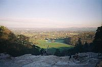 From its highest point, the Edge affords panoramic views across Cheshire and the Peak District
and walking paths through the property, as well as one to nearby National Trust property Hare Hill
. From the Edge, the Cheshire Plain
, can be seen extending from the area of Macclesfield Forest
on the south east side with its with undulating land and woods, towards the extreme easterly point of the Derbyshire
peaks, and northerly to Manchester
and Blackstone Edge
in Yorkshire
.
Until trees were planted at the Edge (1745–1755), visitors to the Edge could see a full 360° panorama of the country around; today the view from the Edge itself is limited to the northerly and easterly directions. Trees now obscure the views in other directions, including views of the Wrekin in Shropshire
to the south; The Cloud
near Bosley
and Mow Cop
(where the Cheshire Plain meets the Peckforton Hills
, Beeston Castle
, and the Delamere Forest
) to the south west; and west to the mountains of North Wales
.
In 1882, George Ormerod
in his book The History of Cheshire described Alderley Edge as "an abrupt and elevated ridge, formerly the site of a Beacon
, which bears the appearance of having been detached by some great convulsion of nature from the range of the Macclesfield hills, as Helsby
and Beeston
seem to have been from those of Delamere
and Peckforton
. Near the summit, "cobalt ore, lead, and copper have been got in small quantities. The sides are varied with cultivated "land, wood, and rock; and the entire mass presents a striking object to all the surrounding district, over which it commands a most extensive prospect."
 The escarpment has long been a site of copper
mining
. Archaeological evidence indicates that mining took place here during Roman
times and the Bronze Age
, and written records show that mining continued here from the 1690s up to the 1920s.
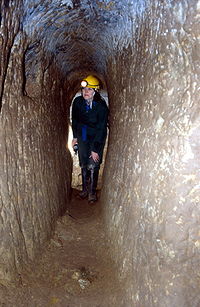
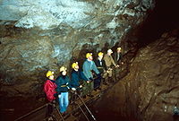
Today, the mines are accessible to the public twice a year, during events organised by the Derbyshire Caving Club.
 In the 19th century, crudely shaped stones were found in the bottom of old workings and were thought to be Bronze Age
hammer stones (Boyd Dawkins, 1876). At the same time, a wooden shovel was found and recorded in 1878. Roeder and Graves wrote two papers in the early 20th century (Roeder, 1902 and Roeder and Graves, 1905) about the findings in 1878 and added to the theory of Bronze Age working that there was a possibility of Roman mining. The picture was transformed when in 1993 the wooden shovel was rediscovered by English novelist and long-time local citizen Alan Garner
. The shovel was carbon-dated to around 1780 BC (Garner et al., 1994). Subsequently, the Alderley Edge Landscape Project was set up and excavation around Engine Vein revealed what are believed to be Bronze Age smelting hearths dating to around 2000 BC (Timberlake and Prag, 2005).
Roman mining was considered unlikely until the finding in 1995 of a 4th-century Roman coin hoard in an abandoned shaft at Engine Vein. This dated the shaft to the 4th century and its regularity and depth suggested that the Romans may well have worked it. An archaeological excavation was undertaken by DCC members supervised by the Alderley Edge Landscape Project archaeologists and, at the bottom, timbers were revealed which were carbon-dated to the last century BC. Given that they were heartwood from cut timbers, the dating cannot be precise and the shaft is now believed to be Roman in origin. The passage from the shaft to the Vein was driven from the direction of the shaft and resembles other Roman workings in the United Kingdom
, such as at Dolaucothi.
Between the Roman working and 1690, there is scant evidence of mining except a reference to "mine holes" (reference in AELPHER archive which is currently inaccessible - May 2007) which cannot be relied on as evidence of mining in progress.
of Macclesfield who worked the mines from 1758 to 1768 before moving over to Anglesey on the discovery of major deposits of copper at Parys Mountain
(Bentley Smith, 2005).
 Apart from Roe, the history of working up to 1857 is patchy. The best recorded period was between about 1805 and 1815 when a company of local men including a Derbyshire miner, James Ashton, tried to exploit the mines for lead. During the course of their work, they identified the presence of cobalt
which was in demand during the Napoleonic blockade of supplies (Bakewell, 1811). Evidence in the field points to the working of a series of mines on a north-south fault running from Saddlebole to Findlow Hill Wood. Some parts of Engine Vein and possibly West Mine appear to have been excavated at this time. The work ended when the price of cobalt fell. The leases for the period tell the story for Ashton who sacrificed his salary for his share in the company, but even lost this when the company called for more capital than he could provide — and yet he was the man down the mine doing the work (Anon, 1808).
 There were some small and unsuccessful attempts to re-open the mines in 1911 (Anon, 1911), during the First World War and shortly after but these ended in a sale of equipment in 1926 (Warrington, 1981). From the 1860s onwards, there have been many thousands of visitors to the mines, many - including the earliest - with good lighting and experienced leaders. However, many other visitors, especially between 1940 and 1960, were ill-equipped and unprepared. This led to a series of tragic accidents which gained the mines a notoriety which still haunts them today. The West and Wood Mines were finally blocked in the early 1960s (Jones, 1961). In 1969, the Derbyshire Caving Club obtained permission from the National Trust (the owners) to re-open Wood Mine and since then much has been found by excavation and exploration and thousands of people have visited the mines in supervised groups.
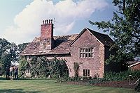 There are many historic buildings including Chorley Old Hall
, which is the oldest surviving manor house in Cheshire.
To the south of the village is the Alderley Park estate, former ancestral home of the Stanley(s)
.
 The location of the Iron Gates is unknown but they are supposed to lie between Stormy Point and the Holy Well.
Tradition says that a farmer from Mobberley
was taking a milk white horse to sell at the market in Macclesfield. Whilst walking along the Edge, he reached a spot known locally as "Thieves Hole." Suddenly an old man clad in a grey and flowing garment stopped him. The old man offered the farmer a sum of money for his horse but the farmer refused, saying he could get a better price at the market. The old man told the farmer that he would be at this spot again that evening when the farmer returned, not having found a purchaser for the horse. The farmer failed to sell the horse and, cursing his luck, made the journey back home along the Edge. At the same point, the old man appeared again, offering the farmer the money, which this time was accepted. The old man told the farmer to follow him with the horse. As they approached an area just past Stormy Point, the old man banged on the ground with his stick and, to the farmer’s shock, the rock opened up to reveal a set of Iron Gates. The old man beckoned the farmer to follow him through the gates into a large cavern. In the cavern, the farmer saw countless men and white horses, all asleep. The old man explained that all these sleeping warriors were ready to awake and fight should England fall into danger. The farmer was shown back to the gates and stepped outside back onto the path. Immediately the gates slammed shut and the rock face returned to its previous state.
There are several versions of the same legend from different places. A letter published in the Manchester Mail in 1805 signed by a gentleman known as "A Perambulator" supposes that this gentleman has knowledge of the location of the Iron Gates near Stormy Point, but no other person has claimed to have found them. Further variations say that the Wizard was Merlin
and the sleeping men were King Arthur
and his army. Yet another version sees the old man saying to the farmer "There will come a day when these men awake from their enchanted slumber and will descend the plain, decide the fate of a great battle and save their country. This shall happen when George the son of George shall reign."
and the horses are black. Once in the cave, the old man asks the farmer to choose between a sword and a horn. The farmer chooses the horn, and immediately the horses all jump up and start to stamp their hooves on the ground. The terrified farmer is expelled from the cave by a whirlwind and hears the words "Woe is the coward that ever was born, that did not draw the sword but blew the horn". This tale is actually very similar, including the sword and horn words, to a tale told by Sir Walter Scott where the action takes place not at Alderley but in the Eildon Hills in Scotland
.
An alternative reading of this and other local legends can be found in Alan Garner
's novels The Weirdstone of Brisingamen
and The Moon of Gomrath
. Garner, born in Congleton, was raised in Alderley Edge.
bars have been found at Alderley Edge. The first was found at the side of Artists Lane. Because this bar was obviously old and consisted of gold, it was declared treasure trove
. A treasure trove inquest was held in Congleton
on 26 February 1993.
John Cherry from the British Museum
along with Adrian Tindall, the Principal Conservation Officer (Archaeology) for Cheshire County Council
made reports on the bar, and determined the gold bar weighed 97.01 grams and was determined to be 73% gold,
Following this inquest the media interest increased and numerous people descended on the Edge hoping to find their own gold bars. The result of all the searching was that 5 more gold bars were found. These bars were also analysed by the British Museum. The weight and gold content of the bars has been given as:
Bars 1/2/3 found on 23 June 1993 - 101.2 grams bar determined to be 76% gold / 97 grams bar determined to be 76% gold / 100.06 grams bar determined to be 75% gold
Bar 4 found on 9 October 1997 - 81.9 grams bar determined to be 60% gold
Bar 5 was found in the 1960s but not declared to the authorities until 1997 - 100.7 grams bar determined to be 74% gold
has been built, starting at the Harden roundabout at the south end of the existing Wilmslow
bypass and going west of Alderley Edge and rejoining the A34 at the bend about 400 yards north of the south gate of Astra Zeneca's laboratory grounds. The bypass will hopefully go a long way to relieving the congestion caused by the 26,000 vehicles that currently pass through Alderley Edge daily. The project cost £56 million and Birse Civils
are the contractor
for the main civil engineering
works. Further information and up-to-date news on the progression of the bypass can be found on alderleyedge.com
Building the bypass disrupted traffic in the area:
The bypass was officially opened on Friday, 19 November 2010 http://www.alderleyedge.com/news/article/3299/alderley-edge-bypass-open-at-long-last, "over 6 months before schedule" according to a notice that contractors put up at its south end.
As at 14 January 2011 some country lanes between the A535 and the A34 were still one-way.
The roundabout at its south end is called Frog Lane Roundabout.
There are still (as at 14 January 2011) roadworks at Monks Heath and elsewhere in the area.
Alderley Edge has a thriving nightlife with a number of popular restaurants, bars and pubs, including Panacea, the Bubble Room, the Alderley Bar and Grill and London Road, often frequented by personalities form the world of sport and entertainment.
The Edge (not the village) and the country south of it was the setting for Alan Garner
's novels The Weirdstone of Brisingamen
and The Moon of Gomrath
.
Founded in 2007 by Mike Nolan - Head Coach and Jonathan Rowley - Chairman the club has grown from 14 original players to 60 children in the 2009 season covering ages from 7 to 11. The philosophy of the club is based around Pressure Free Junior Football and strives to create a positive impact on young children of the surrounding area.
In summer 2009 Allan Hodges took over as Chairman and Jonathan stepped down to Vice Chairman. The club also maintains the Pavilion on Chorley Hall lane which it has been renovating since 2008.
Cheshire East
Cheshire East is a unitary authority area with borough status in the ceremonial county of Cheshire, England.The borough was established in April 2009 as part of the 2009 structural changes to local government in England, by virtue of an order under the Local Government and Public Involvement in...
and the ceremonial county of Cheshire
Cheshire
Cheshire is a ceremonial county in North West England. Cheshire's county town is the city of Chester, although its largest town is Warrington. Other major towns include Widnes, Congleton, Crewe, Ellesmere Port, Runcorn, Macclesfield, Winsford, Northwich, and Wilmslow...
, England
England
England is a country that is part of the United Kingdom. It shares land borders with Scotland to the north and Wales to the west; the Irish Sea is to the north west, the Celtic Sea to the south west, with the North Sea to the east and the English Channel to the south separating it from continental...
. According to the 2001 census the parish had a population of 4,409.
Alderley Edge lies some 5 miles (8 km) to the northwest of Macclesfield
Macclesfield
Macclesfield is a market town within the unitary authority of Cheshire East, the county palatine of Chester, also known as the ceremonial county of Cheshire, England. The population of the Macclesfield urban sub-area at the time of the 2001 census was 50,688...
and 12 miles (19.3 km) south of Manchester
Manchester
Manchester is a city and metropolitan borough in Greater Manchester, England. According to the Office for National Statistics, the 2010 mid-year population estimate for Manchester was 498,800. Manchester lies within one of the UK's largest metropolitan areas, the metropolitan county of Greater...
. It is situated at the base of a steep and thickly wooded sandstone ridge - Alderley Edge, which is the area's chief topographical feature. Alderley Edge overlooks the Cheshire Plain
Cheshire Plain
The Cheshire Plain is a relatively flat expanse of lowland situated almost entirely within the county of Cheshire in northwest England. It is bounded by the hills of North Wales to the west, and the Peak District of Derbyshire and North Staffordshire to the east and southeast...
.
For the purposes of the Office for National Statistics
Office for National Statistics
The Office for National Statistics is the executive office of the UK Statistics Authority, a non-ministerial department which reports directly to the Parliament of the United Kingdom.- Overview :...
Alderley Edge forms part of the Greater Manchester Urban Area
Greater Manchester Urban Area
The Greater Manchester Urban Area is an area of land defined by the Office for National Statistics consisting of the large conurbation that encompasses the city of Manchester and the continuous metropolitan area that spreads outwards from it, forming much of Greater Manchester in North West England...
.
Alderley Edge, like its neighbour Wilmslow
Wilmslow
-Economy:Wilmslow is well known, like Alderley Edge, for having many famous residents, notably footballers, stars of Coronation Street and rich North West businessmen. The town is part of the so-called Golden Triangle in the north west together with Alderley Edge and Prestbury...
, is famous for its affluence and expensive houses.[2] It has a selection of expensive designer shops and cafe/restaurants that attract people living the true "Cheshire lifestyle", such as the numerous Premiership footballers, WAGs, actors and multi-millionaire North-West business people that live in and around the Wilmslow area.[3] It is one of the most expensive and sought-after places to live in the UK outside of central London.
History
The area around Alderley Edge provides proof of occupation since the MesolithicMesolithic
The Mesolithic is an archaeological concept used to refer to certain groups of archaeological cultures defined as falling between the Paleolithic and the Neolithic....
period with flint implements being found along the line of the sandstone outcrop. Evidence for copper mining in the Bronze Age
Bronze Age
The Bronze Age is a period characterized by the use of copper and its alloy bronze as the chief hard materials in the manufacture of some implements and weapons. Chronologically, it stands between the Stone Age and Iron Age...
has also been discovered to the south of the area, and in 1995 members of the Derbyshire Caving Club discovered a hoard of 564 coins of the Roman Empire
Roman Empire
The Roman Empire was the post-Republican period of the ancient Roman civilization, characterised by an autocratic form of government and large territorial holdings in Europe and around the Mediterranean....
(now in the Manchester Museum
Manchester Museum
The Manchester Museum is owned by the University of Manchester. Sited on Oxford Road at the heart of the university's group of neo-Gothic buildings, it provides access to about six million items from every continent and serves both as a resource for academic research and teaching and as a regional...
) dating from AD 317 to AD 336. There are to date 13 recorded sites on the County Sites and Monuments Record
Sites and Monuments Record
Each County or Unitary Authority in the United Kingdom maintains a Sites and Monuments Record or SMR, consisting of a list of known archaeological sites. Many SMRs are now developing into much broader Historic Environment Records , including information on historic buildings and designed landscapes...
(CSMR) in the settled area of Alderley Edge and 28 in Nether Alderley
Nether Alderley
Nether Alderley is a village and civil parish in the unitary authority of Cheshire East and the ceremonial county of Cheshire, England. It lies on the A34 road about a mile and a half south of Alderley Edge....
, with a further 44 along the Edge itself.
Early medieval settlements are recorded at Nether Alderley, to the south of Alderley Edge. The first written evidence of Alderley Edge, known then as 'Chorlegh' (later spelt as 'Chorley') appeared in the 13th century, with the likely derivation coming from ceorl and leah, meaning a peasants' clearing. Although it is not mentioned in the Domesday Book
Domesday Book
Domesday Book , now held at The National Archives, Kew, Richmond upon Thames in South West London, is the record of the great survey of much of England and parts of Wales completed in 1086...
, it is included in a charter of c.1280. The name 'Alderley' first appears in 1086 as 'Aldredelie'. Several versions of the origin are known, one says it originated from 'Aldred 'and 'leah' meaning 'Aldred's Clearing'. Another says it is most likely that the name Alderley came from Old English language
Old English language
Old English or Anglo-Saxon is an early form of the English language that was spoken and written by the Anglo-Saxons and their descendants in parts of what are now England and southeastern Scotland between at least the mid-5th century and the mid-12th century...
'Alðrȳðelēah' meaning "the meadow or woodland clearing of a woman called 'Alðrȳð'.
In the 13th century and during the Middle Ages
Middle Ages
The Middle Ages is a periodization of European history from the 5th century to the 15th century. The Middle Ages follows the fall of the Western Roman Empire in 476 and precedes the Early Modern Era. It is the middle period of a three-period division of Western history: Classic, Medieval and Modern...
, the area comprised estates that had many different owners, since the 15th century, most of them have belonged to the De Trafford Baronets
De Trafford Baronets
The de Trafford Baronetcy, of Trafford Park in the Metropolitan Borough of Trafford, Greater Manchester, is a title in the Baronetage of the United Kingdom. It was restored after the Catholic Emancipation, by Royal Decree on 7 September 1841, for Thomas de Trafford...
. The principal manors being based on the 14th century Chorley Old Hall
Chorley Old Hall
Chorley Old Hall is a moated manor house on the A535 road to the southwest of Alderley Edge, Cheshire, England. The house has been designated by English Heritage as a Grade I listed building, and the moated site is a scheduled monument...
, which lies to the south-west of Alderley Edge, and the Old Hall, at Nether Alderley, a 16th century building which was burnt down in 1779. The economies of both Chorley and Nether Alderley were dominated by agriculture with a market charter being granted at Nether Alderley in c.1253. Nether Alderley Mill
Nether Alderley Mill
Nether Alderley Mill is a 15th-century watermill located in Nether Alderley, Macclesfield, Cheshire, England. It is in the custodianship of the National Trust....
dates back to 1391, although the present timber structure is only 16th century. The millpond was adapted to form the moat, which surrounded the Old Hall, the home of the Stanley
Stanley
Stanley may refer to:- Australia :* Stanley, Tasmania* Stanley, Victoria* County of Stanley, Queensland- Canada :* Stanley, British Columbia* Stanley, New Brunswick* Port Stanley, Ontario- Falkland Islands :...
family (Baron Stanley of Alderley
Baron Stanley of Alderley
Baron Stanley of Alderley, in the County of Chester, is a title in the Peerage of the United Kingdom. It was created in 1839 for the politician and landowner Sir John Stanley, 7th Baronet....
). The corn mill continued to be worked until 1939 when Lord Stanley was forced to sell it, along with the rest of his estate, to meet the cost of death duties. In the 1950s the National Trust for Places of Historic Interest or Natural Beauty
National Trust for Places of Historic Interest or Natural Beauty
The National Trust for Places of Historic Interest or Natural Beauty, usually known as the National Trust, is a conservation organisation in England, Wales and Northern Ireland...
bought the site and have since restored the building and opened it to the public.
Cheshire had its own system of taxes in the medieval period, the Mize, and in the records for 1405 Chorley was assessed at 20s 0d and Nether Alderley at 27s 0d.
Lead and copper mining on the Edge is documented in the late 17th century and 18th century. After the destruction of the Old Hall in the late 18th century, the Stanley family relocated to Park House on the southern edge of Alderley Park, and both house and park were subsequently much extended. Throughout the 19th century Nether Alderley remained under the control of the Stanleys and the lack of development pressure meant that the dispersed medieval settlement pattern was retained. In 1830 Chorley consisted of only a few cottages, the De Trafford Arms Inn, a toll bar, and a smithy, straggling along the Congleton
Congleton
Congleton is a town and civil parish in the unitary authority of Cheshire East and the ceremonial county of Cheshire, England, on the banks of the River Dane, to the west of the Macclesfield Canal and 21 miles south of Manchester. It has a population of 25,750.-History:The first settlements in...
to Manchester Road.
The coming of the railway in 1842 with the construction of the Stockport
Stockport
Stockport is a town in Greater Manchester, England. It lies on elevated ground southeast of Manchester city centre, at the point where the rivers Goyt and Tame join and create the River Mersey. Stockport is the largest settlement in the metropolitan borough of the same name...
to Crewe
Crewe
Crewe is a railway town within the unitary authority area of Cheshire East and the ceremonial county of Cheshire, England. According to the 2001 census the urban area had a population of 67,683...
section of the main Manchester and Birmingham Railway
Manchester and Birmingham Railway
The Manchester and Birmingham Railway was built between Manchester and Crewe and opened in stages from 1840. Between Crewe and Birmingham, trains were worked by the Grand Junction Railway...
changed all this. The Manchester and Birmingham Railway
Manchester and Birmingham Railway
The Manchester and Birmingham Railway was built between Manchester and Crewe and opened in stages from 1840. Between Crewe and Birmingham, trains were worked by the Grand Junction Railway...
Company built the line through Chorley, offering free season tickets for 20 years to Manchester businessmen who built houses with a rateable value of more than £50 within a mile of the station. This 'season ticket' was in the form of a small silver oval which could be worn on a watch chain.
The railway also gave Alderley Edge its current name. As the railway network expanded and travel became easier, the railway company did not want its station called Chorley any more because of the possible confusion with Chorley
Chorley
Chorley is a market town in Lancashire, in North West England. It is the largest settlement in the Borough of Chorley. The town's wealth came principally from the cotton industry...
in Lancashire
Lancashire
Lancashire is a non-metropolitan county of historic origin in the North West of England. It takes its name from the city of Lancaster, and is sometimes known as the County of Lancaster. Although Lancaster is still considered to be the county town, Lancashire County Council is based in Preston...
. So, in 1880 they renamed it Alderley Edge railway station
Alderley Edge railway station
Alderley Edge railway station serves the large village of Alderley Edge in Cheshire, England. The station is 22 km south of Manchester Piccadilly on the Crewe to Manchester Line .-History:...
against much opposition, taking the old name for the village and the name of the sandstone escarpment already known as The Edge. The name Chorley, Macclesfield
Chorley, Macclesfield
Chorley is a civil parish in the unitary authority of Cheshire East and the ceremonial county of Cheshire, England. The parish itself contains no large settlement, but there is a small hamlet called Row-of-Trees in the north of the parish...
is retained by the civil parish to the northwest of Alderley Edge.
Following the construction of the railway, the local landowner, Sir Humphrey de Trafford, of Chorley Hall, laid out an extensive estate of new roads and new houses were incrementally added, filling-in most of the available sites by 1910. Of these, nine are now listed grade II. The area boundary largely reflects de Trafford's original estate boundaries. Also because of the railway, Alderley became a popular place to visit and the railway company popularised day trips and cheap excursions to the village.
This period also saw the appearance of buildings which are now landmarks. St Philip's Church, Alderley Edge
St Philip's Church, Alderley Edge
St Philip's Church, Alderley Edge, is in the village of Alderley Edge, Cheshire, England. The church has been designated by English Heritage as a Grade II* listed building. It is an active Anglican parish church in the diocese of Chester, the archdeaconry of Macclesfield and the deanery of...
with its 175 ft (53.3 m) spire was built in 1853 and the village primary school a year later known as Alderley Edge Community Primary School http://www.hostedonharper.co.uk/cheshire/alderleyedge/. Two all girls schools were opened, St Hilary's in 1876 and Mount Carmel in 1945, which then merged in 1999 to form Alderley Edge School for Girls
Alderley Edge School for Girls
Alderley Edge School for Girls is an independent day school for girls, located in rural Cheshire in the village of Alderley Edge, England. The school caters for pupils aged three to eighteen, providing both secondary and primary school education, as well as a nursery and sixth form...
. A boys' school, The Ryleys School
The Ryleys School
The Ryleys School, located in Alderley Edge, Cheshire is a preparatory school for boys aged between 2½ to 11 or 13. It was founded in 1877 above the village chemist, before moving to its present location and changing name in the early 1880s. Until 2006, the school also provided boarding facilities...
, was opened in 1877. The Mission Hall (later known as The Institute) was built as a temperance hall for the recreation of the 'lower classes' by the wealthier residents in 1878. The Methodist Church in Chapel Road was built ten years after St Philip's.
The area is notable for its heavily wooded streets and substantial Victorian
Victorian era
The Victorian era of British history was the period of Queen Victoria's reign from 20 June 1837 until her death on 22 January 1901. It was a long period of peace, prosperity, refined sensibilities and national self-confidence...
villas set in spacious, well-planted gardens. The first villa was constructed in the early 1840s and by 1850 thirty "handsome residences" had been erected, some of them in what is now the Alderley Edge Conservation Area. The cotton barons from Manchester built their mansions here and now they are changing hands for several million pounds. The village itself winds up a high street bristling with chic restaurants, designer shops and speciality food shops. Around the village, winding lanes are covered in their original sandstone setts and front boundary walls are usually built from the same local sandstone. The buildings are very varied in style with examples of Tudor
Tudor style architecture
The Tudor architectural style is the final development of medieval architecture during the Tudor period and even beyond, for conservative college patrons...
, Italian
Italianate architecture
The Italianate style of architecture was a distinct 19th-century phase in the history of Classical architecture. In the Italianate style, the models and architectural vocabulary of 16th-century Italian Renaissance architecture, which had served as inspiration for both Palladianism and...
, neo-Georgian and Arts and Crafts Movement
Arts and Crafts movement
Arts and Crafts was an international design philosophy that originated in England and flourished between 1860 and 1910 , continuing its influence until the 1930s...
designs. The wide range of materials used reflects this somewhat eclectic mix of styles, and include stone, brick (several colours) smooth render or roughcast for the walls, and Welsh
Wales
Wales is a country that is part of the United Kingdom and the island of Great Britain, bordered by England to its east and the Atlantic Ocean and Irish Sea to its west. It has a population of three million, and a total area of 20,779 km²...
slate or clay tiles for the roofs.
The growth of Alderley Edge is recorded in the census returns; with the population rising from 561 in 1841 to 2856 in 1902 (the return for Nether Alderley shows a drop from 679 to 522 within the same period). There was no church in Chorley until 1852, when the larger expansion of the town in the demanded enlarged accommodation, but St Mary's Church in Nether Alderley retains some 14th century work including a font.
The First Edition Ordnance Survey
Ordnance Survey
Ordnance Survey , an executive agency and non-ministerial government department of the Government of the United Kingdom, is the national mapping agency for Great Britain, producing maps of Great Britain , and one of the world's largest producers of maps.The name reflects its creation together with...
map of 1871 therefore shows "Chorley" (as it still was) with the new Queen's Hotel next to the station, new shops and terraced houses along London Road, and a Post Office
Post office
A post office is a facility forming part of a postal system for the posting, receipt, sorting, handling, transmission or delivery of mail.Post offices offer mail-related services such as post office boxes, postage and packaging supplies...
at the town centre, where Macclesfield Road meets Alderley Road. To the north are wooded areas with detached villas, but to the east is a much larger area, roughly approximating with the modern conservation area, where curving roads divide generous wooded plots, usually with its own house, although some plots remained undeveloped until much later. Of interest is the use of the names "Brickfield" and "Brick kiln" on a site to the north-east of Alderley Edge, suggesting a source for the local bricks.
The 1899 map shows a similar footprint but it is much easier to make out the individual villas and their names – Holybank, Ashfield, The Larches etc. Also very evident on this map are the remains of the old mines towards and within Windmill Wood, immediately to the southeast. In the 20th century, Alderley Edge continued to expand with much Post-War housing around the northeastern and western edges. Nether Alderley has remained relatively unchanged, apart from the sale of Alderley Park to Astra Zeneca (previously ICI, Imperial Chemical Industries
Imperial Chemical Industries
Imperial Chemical Industries was a British chemical company, taken over by AkzoNobel, a Dutch conglomerate, one of the largest chemical producers in the world. In its heyday, ICI was the largest manufacturing company in the British Empire, and commonly regarded as a "bellwether of the British...
), which now has a large research establishment based on Alderley Hall.
Administrative history
From medieval times the area was part of the Chorley township of the ancient parish of WilmslowWilmslow
-Economy:Wilmslow is well known, like Alderley Edge, for having many famous residents, notably footballers, stars of Coronation Street and rich North West businessmen. The town is part of the so-called Golden Triangle in the north west together with Alderley Edge and Prestbury...
in the Macclesfield Hundred
Macclesfield (hundred)
The hundred of Macclesfield was an ancient division of the historic county of Cheshire, in northern England. It was known to have been in existence at least as early as 1242, and it was formed to a great extent from the earlier Domesday hundred of Hamestan...
of Cheshire. Under the Poor Law Amendment Act 1866 Chorley became a civil parish in its own right. Alderley Edge civil parish was created on 31 December 1894 from part of Chorley civil parish. Along with Bollinfee civil parish it formed Alderley Edge Urban District. In 1974 it became a civil parish in the new non-metropolitan district
Non-metropolitan district
Non-metropolitan districts, or colloquially shire districts, are a type of local government district in England. As created, they are sub-divisions of non-metropolitan counties in a so-called "two-tier" arrangement...
of Macclesfield
Macclesfield (borough)
Macclesfield was, from 1974 to 2009, a local government district with borough status in Cheshire, England. It included the towns of Bollington, Knutsford, Macclesfield and Wilmslow and within its wider area the villages and hamlets of Adlington, Disley, Gawsworth, Kerridge, Pott Shrigley, Poynton,...
. Since 1 April 2009 it has been part of the unitary authority of Cheshire East
Cheshire East
Cheshire East is a unitary authority area with borough status in the ceremonial county of Cheshire, England.The borough was established in April 2009 as part of the 2009 structural changes to local government in England, by virtue of an order under the Local Government and Public Involvement in...
.
Boundary changes
The civil parish was enlarged on 30 September by gaining a further part of Chorley. On 1 October 1910 it was enlarged by gaining part of Nether AlderleyNether Alderley
Nether Alderley is a village and civil parish in the unitary authority of Cheshire East and the ceremonial county of Cheshire, England. It lies on the A34 road about a mile and a half south of Alderley Edge....
civil parish. It was further enlarged on 1 April 1936 by the transfer of a further 2 acres (8,093.7 m²) from Chorley and 19 acres (76,890.3 m²) from Wilmslow
Wilmslow
-Economy:Wilmslow is well known, like Alderley Edge, for having many famous residents, notably footballers, stars of Coronation Street and rich North West businessmen. The town is part of the so-called Golden Triangle in the north west together with Alderley Edge and Prestbury...
civil parish and by gaining 112 acre (0.45324832 km²) on the abolition of Bollinfee civil parish.
The Edge Association
The Edge Association is a local residents' group which campaigns on matters relevant to Alderley Edge.Economy
As of the 2001 UK census, the Alderley Edge ward had a possible workforce of approximately 2157 people. The economic activity of residents in the Alderley Edge electoral ward was 36.9% in full-time employment, 10.2% in part-time employment, 29.3% self-employed, 1.7% unemployed, 1.4% students with jobs, 3.5% students without jobs, 19.3% retired, 7.5% looking after home or family, 2.8% permanently sick or disabled and 2.0% economically inactive for other reasons. Alderley Edge has a very high rate of self employment (29.3%) compared with rest of the Macclesfield borough (22.7%) and England (16.6%). Alderley Edge also has low rates of unemployment (1.7%) compared with the rest of the Macclesfield borough (2.0%) and England (3.3%). The Office for National StatisticsOffice for National Statistics
The Office for National Statistics is the executive office of the UK Statistics Authority, a non-ministerial department which reports directly to the Parliament of the United Kingdom.- Overview :...
estimated that during the period of April 2001 to March 2002 the average gross weekly income of households in Alderley Edge was £720 (£37,440 per year).
Notable people
Notable people from Alderley Edge include:- The novelist Alan GarnerAlan GarnerWith his first book published, Garner abandoned his work as a labourer and gained a job as a freelance television reporter, living a "hand to mouth" lifestyle on a "shoestring" budget...
, who spent much of his childhood there and used it as the principal scene of his fantasyFantasyFantasy is a genre of fiction that commonly uses magic and other supernatural phenomena as a primary element of plot, theme, or setting. Many works within the genre take place in imaginary worlds where magic is common...
classics The Weirdstone of BrisingamenThe Weirdstone of BrisingamenThe Weirdstone of Brisingamen is a children's fantasy novel by English author Alan Garner, first published in 1960. The novel is set in and around Macclesfield and Alderley Edge in Cheshire, and tells the story of two children, Colin and Susan, who are staying with some old friends of their mother...
and The Moon of GomrathThe Moon of GomrathThe Moon of Gomrath is a fantasy story by the author Alan Garner, published in 1963. It is the sequel to The Weirdstone of Brisingamen.-Plot synopsis:...
.
- Musician Bernard SumnerBernard SumnerBernard Sumner , also known as Bernard Dickin, Bernard Dicken and Bernard Albrecht is an English singer-songwriter, guitarist, keyboard player and producer....
of Joy DivisionJoy DivisionJoy Division were an English rock band formed in 1976 in Salford, Greater Manchester. Originally named Warsaw, the band primarily consisted of Ian Curtis , Bernard Sumner , Peter Hook and Stephen Morris .Joy Division rapidly evolved from their initial punk rock influences...
, New OrderNew OrderNew Order are an English rock band formed in 1980 by Bernard Sumner , Peter Hook and Stephen Morris...
and Bad Lieutenant (band)Bad Lieutenant (band)Bad Lieutenant are an English alternative rock band formed in 2007 following the breakup of New Order. The band consists of Bernard Sumner, Stephen Morris, Phil Cunningham, Jake Evans and Tom Chapman....
lives here with his family, as does his band mate Peter HookPeter HookPeter Hook is an English bass player, musician and author.He was a co-founder of the post-punk band Joy Division along with Bernard Sumner in the mid-1970s. Following the death of lead singer Ian Curtis, the band reformed as New Order, and Hook played bass with them throughout their career until...
.
David Beckham
David Beckham
David Robert Joseph Beckham, OBE is an English footballer who plays midfield for Los Angeles Galaxy in Major League Soccer, having previously played for Manchester United, Preston North End, Real Madrid, and A.C...
and his family lived here until he was transferred to Real Madrid football club
Real Madrid C.F.
Real Madrid Club de Fútbol , commonly known as Real Madrid, is a professional football club based in Madrid, Spain. The club have won a record 31 La Liga titles, the Primera División of the Liga de Fútbol Profesional , 18 Copas del Rey, 8 Spanish Super Cups, 1 Copa Eva Duarte and 1 Copa de la...
.
The area is also the home of a number of other affluent people, many of whom are multi-millionaires (particularly football players, pop stars and business people), including Manchester United players Rio Ferdinand
Rio Ferdinand
Rio Gavin Ferdinand is an English footballer. He plays at centre back for Manchester United in the Premier League and for the England national football team...
and Michael Carrick
Michael Carrick
Michael Carrick is an English footballer who plays as a midfielder for Manchester United and the England national team. He has made more than 300 Premier League appearances and played in 50 UEFA Champions League games as of April 2011...
. Former players Cristiano Ronaldo
Cristiano Ronaldo
Cristiano Ronaldo dos Santos Aveiro, OIH, , commonly known as Cristiano Ronaldo, is a Portuguese footballer who plays as a winger or striker for Spanish La Liga club Real Madrid and is the captain of the Portuguese national team...
, and Mikaël Silvestre
Mikael Silvestre
Mikaël Samy Silvestre is a French international footballer. He plays as defender and is currently signed with Werder Bremen of the Bundesliga. He has also played for the French national team...
also used to live there and, as well as former Liverpool
Liverpool F.C.
Liverpool Football Club is an English Premier League football club based in Liverpool, Merseyside. Liverpool has won eighteen League titles, second most in English football, seven FA Cups and a record seven League Cups...
(now Stoke City
Stoke City F.C.
Stoke City Football Club is an English professional football club based in Stoke-on-Trent, Staffordshire that plays in the Premier League. Founded in 1863, it is the oldest club in the Premier League, and considered to be the second oldest professional football club in the world, after Notts...
) star Peter Crouch
Peter Crouch
Peter James Crouch is an English footballer who plays as a striker for Premier League club Stoke City and the England national team.Crouch started his career as a trainee with Tottenham Hotspur...
and well known footballer Andy Cole
Andy Cole
Andrew Alexander Cole is a retired English footballer. He is most well known by the name Andy Cole , but in 2000, he reputedly asked to be known as Andrew Cole...
. A number of Coronation Street
Coronation Street
Coronation Street is a British soap opera set in Weatherfield, a fictional town in Greater Manchester based on Salford. Created by Tony Warren, Coronation Street was first broadcast on 9 December 1960...
actors, including Denise Welch
Denise Welch
Jacqueline Denise Healy is an English actress, dancer and television presenter.-Early life:Denise Welch was born in Ebchester, County Durham, to father Vin and mother Ann and has a younger sister Debbie...
and Richard Fleeshman
Richard Fleeshman
Richard Jonathan Fleeshman is an English actor and singer-songwriter. His television career began as a twelve year old, playing Craig Harris for four years in Coronation Street and most recently "All The Small Things"...
also live in the village. Other famous members of the community include property entrepreneur Peter Jones and TV presenter and voice-over artist Stuart Hall.
The Edge
New Red Sandstone
The New Red Sandstone is a chiefly British geological term for the beds of red sandstone and associated rocks laid down throughout the Permian to the beginning of the Triassic that underlie the Jurassic Lias; the term distinguishes it from the Old Red Sandstone which is largely Devonian in...
escarpment
Escarpment
An escarpment is a steep slope or long cliff that occurs from erosion or faulting and separates two relatively level areas of differing elevations.-Description and variants:...
situated above the village of Alderley. An edge is a name used as a descriptive term for high land in Cheshire and adjacent counties, such as in Wenlock Edge
Wenlock Edge
Wenlock Edge is a limestone escarpment near Much Wenlock, Shropshire, England. It is long and runs from South West to North East between Craven Arms and Much Wenlock. It is roughly 330 metres high...
and Blackstone Edge
Blackstone Edge
Blackstone Edge is a gritstone escarpment at 1,549 feet above sea level in an area of moorland on the Greater Manchester–West Yorkshire county boundary, England....
. The Edge at Alderley is a ridge of land which separates a narrow and short valley from the higher ground of south east Cheshire and Derbyshire
Derbyshire
Derbyshire is a county in the East Midlands of England. A substantial portion of the Peak District National Park lies within Derbyshire. The northern part of Derbyshire overlaps with the Pennines, a famous chain of hills and mountains. The county contains within its boundary of approx...
. It rises gradually from the town of Macclesfield, until, at a distance of 7 or 8 kilometres, it terminates abruptly, having reached a height of nearly 215 metres above sea level, and 110 metres above the Cheshire Plain
Cheshire Plain
The Cheshire Plain is a relatively flat expanse of lowland situated almost entirely within the county of Cheshire in northwest England. It is bounded by the hills of North Wales to the west, and the Peak District of Derbyshire and North Staffordshire to the east and southeast...
below it.
It was formed partly by the weathering of resistant sandstone which lies on top of a softer sandstone, and partly by faulting of the rocks. The scarp or slope is repeated eight times by faults of up to 200 metres which has thrown down blocks of sandstone west to Alderley and east to the village of Kirkleyditch . The northern side of the Edge is shaped like a horse shoe or hough
Hough
Hough may refer to:* Hamstringing or severing the Achilles tendon of an animal* the leg or shin of an animal , from which the dish potted hough is made-Places:* Hough, Cheshire, a village in north-west England, UK...
, as this type of ridge is called in Cheshire. The Edge also marks the line of a hamlet of scattered houses called "The Hough" which descend towards Alderley village.
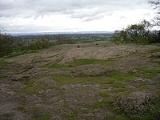
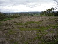
Today, Alderley Edge is owned by the National Trust
National Trust for Places of Historic Interest or Natural Beauty
The National Trust for Places of Historic Interest or Natural Beauty, usually known as the National Trust, is a conservation organisation in England, Wales and Northern Ireland...
and maintained as a public access wooded area. It has been designated a Site of Special Scientific Interest
Site of Special Scientific Interest
A Site of Special Scientific Interest is a conservation designation denoting a protected area in the United Kingdom. SSSIs are the basic building block of site-based nature conservation legislation and most other legal nature/geological conservation designations in Great Britain are based upon...
for its unique geology. The Edge is a popular destination for day trippers from Manchester and the nearby towns of Wilmslow
Wilmslow
-Economy:Wilmslow is well known, like Alderley Edge, for having many famous residents, notably footballers, stars of Coronation Street and rich North West businessmen. The town is part of the so-called Golden Triangle in the north west together with Alderley Edge and Prestbury...
and Macclesfield. The whole woodland is riddled with old mine workings and relics of by-gone times.
Views
Peak District
The Peak District is an upland area in central and northern England, lying mainly in northern Derbyshire, but also covering parts of Cheshire, Greater Manchester, Staffordshire, and South and West Yorkshire....
and walking paths through the property, as well as one to nearby National Trust property Hare Hill
Hare Hill
Hare Hill is a country house and a garden in the parish of Over Alderley, Cheshire, England. The house is privately owned, and the garden is in the care of the National Trust.-House:...
. From the Edge, the Cheshire Plain
Cheshire Plain
The Cheshire Plain is a relatively flat expanse of lowland situated almost entirely within the county of Cheshire in northwest England. It is bounded by the hills of North Wales to the west, and the Peak District of Derbyshire and North Staffordshire to the east and southeast...
, can be seen extending from the area of Macclesfield Forest
Macclesfield Forest
Macclesfield Forest is an area of woodland, predominantly conifer plantation, located around south east of Macclesfield in the civil parish of Macclesfield Forest and Wildboarclough, in Cheshire, England. The existing woodland is the last substantial remnant of the Royal Forest of Macclesfield, a...
on the south east side with its with undulating land and woods, towards the extreme easterly point of the Derbyshire
Derbyshire
Derbyshire is a county in the East Midlands of England. A substantial portion of the Peak District National Park lies within Derbyshire. The northern part of Derbyshire overlaps with the Pennines, a famous chain of hills and mountains. The county contains within its boundary of approx...
peaks, and northerly to Manchester
Manchester
Manchester is a city and metropolitan borough in Greater Manchester, England. According to the Office for National Statistics, the 2010 mid-year population estimate for Manchester was 498,800. Manchester lies within one of the UK's largest metropolitan areas, the metropolitan county of Greater...
and Blackstone Edge
Blackstone Edge
Blackstone Edge is a gritstone escarpment at 1,549 feet above sea level in an area of moorland on the Greater Manchester–West Yorkshire county boundary, England....
in Yorkshire
Yorkshire
Yorkshire is a historic county of northern England and the largest in the United Kingdom. Because of its great size in comparison to other English counties, functions have been increasingly undertaken over time by its subdivisions, which have also been subject to periodic reform...
.
Until trees were planted at the Edge (1745–1755), visitors to the Edge could see a full 360° panorama of the country around; today the view from the Edge itself is limited to the northerly and easterly directions. Trees now obscure the views in other directions, including views of the Wrekin in Shropshire
Shropshire
Shropshire is a county in the West Midlands region of England. For Eurostat purposes, the county is a NUTS 3 region and is one of four counties or unitary districts that comprise the "Shropshire and Staffordshire" NUTS 2 region. It borders Wales to the west...
to the south; The Cloud
The Cloud (Peak District)
The Cloud is a distinctive hill which lies on the border between Cheshire and Staffordshire just a couple of miles to the west of the Peak District National Park boundary.At in height, it is one of the highest hills in the area...
near Bosley
Bosley
Bosley is a village and civil parish in the unitary authority of Cheshire East and the ceremonial county of Cheshire, England. According to the 2001 census it had a population of 406. The village is on the A523 road about six miles south of Macclesfield...
and Mow Cop
Mow Cop
Mow Cop is an isolated village which straddles the Cheshire–Staffordshire border, and is thus divided between the North West and West Midlands regions of England...
(where the Cheshire Plain meets the Peckforton Hills
Peckforton Hills
The Peckforton Hills are a sandstone ridge running broadly northeast–southwest in the west of the English county of Cheshire. They form a significant part of the longer Mid Cheshire Ridge which extends southwards from Frodsham towards Malpas....
, Beeston Castle
Beeston Castle
Beeston Castle is a former Royal castle in Beeston, Cheshire, England , perched on a rocky sandstone crag above the Cheshire Plain. It was built in the 1220s by Ranulf de Blondeville, 6th Earl of Chester, , on his return from the Crusades...
, and the Delamere Forest
Delamere Forest
Delamere Forest or Delamere Forest Park is a wood in the Cheshire West and Chester area of Cheshire, England, near the town of Frodsham. It includes of mixed deciduous and evergreen woodland, centred at around , making it the largest area of woodland in Cheshire...
) to the south west; and west to the mountains of North Wales
North Wales
North Wales is the northernmost unofficial region of Wales. It is bordered to the south by the counties of Ceredigion and Powys in Mid Wales and to the east by the counties of Shropshire in the West Midlands and Cheshire in North West England...
.
History
The Edge was described as a dreary common till the year 1779, when it was enclosed together with all the other waste lands of Alderley. Some hundreds of Scotch firs were planted on the highest points by Sir James and Sir Edward Stanley, between the years 1745 and 1755, before that time, it does not appear that a single tree grew on it.In 1882, George Ormerod
George Ormerod
George Ormerod was an English antiquary and historian. Amongst his writings was a major account of the history of Cheshire, a county in northwestern England.-Biography:...
in his book The History of Cheshire described Alderley Edge as "an abrupt and elevated ridge, formerly the site of a Beacon
Beacon
A beacon is an intentionally conspicuous device designed to attract attention to a specific location.Beacons can also be combined with semaphoric or other indicators to provide important information, such as the status of an airport, by the colour and rotational pattern of its airport beacon, or of...
, which bears the appearance of having been detached by some great convulsion of nature from the range of the Macclesfield hills, as Helsby
Helsby
Helsby is a large village and civil parish in the unitary authority of Cheshire West and Chester and the ceremonial county of Cheshire, England. At the 2001 Census, Helsby had a population of 4,701.-Geography:...
and Beeston
Beeston, Cheshire
Beeston is a village and civil parish in the unitary authority of Cheshire West and Chester and the ceremonial county of Cheshire in the north of England. It is south of Tarporley, and close to the Shropshire Union Canal. Beeston Castle nearby is a spectacular clifftop ruin in the care of English...
seem to have been from those of Delamere
Delamere
Delamere may mean:*Baron Delamere*Tuariki Delamere*Delamere, Cheshire*Delamere Forest, also in Cheshire*Delamere, Ontario*Delamere, South Australia...
and Peckforton
Peckforton
Peckforton is a scattered settlement and civil parish in the unitary authority of Cheshire East and the ceremonial county of Cheshire, England. The settlement is located to the north east of Malpas and miles to the west of Nantwich. The total population of the civil parish is somewhat over 100...
. Near the summit, "cobalt ore, lead, and copper have been got in small quantities. The sides are varied with cultivated "land, wood, and rock; and the entire mass presents a striking object to all the surrounding district, over which it commands a most extensive prospect."
Alderley Edge mines
Copper
Copper is a chemical element with the symbol Cu and atomic number 29. It is a ductile metal with very high thermal and electrical conductivity. Pure copper is soft and malleable; an exposed surface has a reddish-orange tarnish...
mining
Mining
Mining is the extraction of valuable minerals or other geological materials from the earth, from an ore body, vein or seam. The term also includes the removal of soil. Materials recovered by mining include base metals, precious metals, iron, uranium, coal, diamonds, limestone, oil shale, rock...
. Archaeological evidence indicates that mining took place here during Roman
Roman Britain
Roman Britain was the part of the island of Great Britain controlled by the Roman Empire from AD 43 until ca. AD 410.The Romans referred to the imperial province as Britannia, which eventually comprised all of the island of Great Britain south of the fluid frontier with Caledonia...
times and the Bronze Age
Bronze Age
The Bronze Age is a period characterized by the use of copper and its alloy bronze as the chief hard materials in the manufacture of some implements and weapons. Chronologically, it stands between the Stone Age and Iron Age...
, and written records show that mining continued here from the 1690s up to the 1920s.
Today, the mines are accessible to the public twice a year, during events organised by the Derbyshire Caving Club.
Pre-history
Bronze Age
The Bronze Age is a period characterized by the use of copper and its alloy bronze as the chief hard materials in the manufacture of some implements and weapons. Chronologically, it stands between the Stone Age and Iron Age...
hammer stones (Boyd Dawkins, 1876). At the same time, a wooden shovel was found and recorded in 1878. Roeder and Graves wrote two papers in the early 20th century (Roeder, 1902 and Roeder and Graves, 1905) about the findings in 1878 and added to the theory of Bronze Age working that there was a possibility of Roman mining. The picture was transformed when in 1993 the wooden shovel was rediscovered by English novelist and long-time local citizen Alan Garner
Alan Garner
With his first book published, Garner abandoned his work as a labourer and gained a job as a freelance television reporter, living a "hand to mouth" lifestyle on a "shoestring" budget...
. The shovel was carbon-dated to around 1780 BC (Garner et al., 1994). Subsequently, the Alderley Edge Landscape Project was set up and excavation around Engine Vein revealed what are believed to be Bronze Age smelting hearths dating to around 2000 BC (Timberlake and Prag, 2005).
Roman mining was considered unlikely until the finding in 1995 of a 4th-century Roman coin hoard in an abandoned shaft at Engine Vein. This dated the shaft to the 4th century and its regularity and depth suggested that the Romans may well have worked it. An archaeological excavation was undertaken by DCC members supervised by the Alderley Edge Landscape Project archaeologists and, at the bottom, timbers were revealed which were carbon-dated to the last century BC. Given that they were heartwood from cut timbers, the dating cannot be precise and the shaft is now believed to be Roman in origin. The passage from the shaft to the Vein was driven from the direction of the shaft and resembles other Roman workings in the United Kingdom
United Kingdom
The United Kingdom of Great Britain and Northern IrelandIn the United Kingdom and Dependencies, other languages have been officially recognised as legitimate autochthonous languages under the European Charter for Regional or Minority Languages...
, such as at Dolaucothi.
Between the Roman working and 1690, there is scant evidence of mining except a reference to "mine holes" (reference in AELPHER archive which is currently inaccessible - May 2007) which cannot be relied on as evidence of mining in progress.
17th and 18th centuries
From 1693 (Anon, 1696) to the mid-19th century, various people are reported to have explored the Edge for copper and work was done at Saddlebole, Stormy Point, Engine Vein and Brinlow (Stanley, 1843). It is likely that the near-surface sections of Wood Mine were investigated during this period. One operator of note was Charles RoeCharles Roe
Charles Roe was an English industrialist. He played an important part in establishing the silk industry in Macclesfield, Cheshire and later became involved in the mining and metal industries.-Early life and career:...
of Macclesfield who worked the mines from 1758 to 1768 before moving over to Anglesey on the discovery of major deposits of copper at Parys Mountain
Parys Mountain
Parys Mountain – in the Welsh language Mynydd Parys – is located south of the town of Amlwch in north east Anglesey, Wales. It is the site of a large copper mine that was extensively exploited in the late 18th century.-History:...
(Bentley Smith, 2005).
Early 19th century
Cobalt
Cobalt is a chemical element with symbol Co and atomic number 27. It is found naturally only in chemically combined form. The free element, produced by reductive smelting, is a hard, lustrous, silver-gray metal....
which was in demand during the Napoleonic blockade of supplies (Bakewell, 1811). Evidence in the field points to the working of a series of mines on a north-south fault running from Saddlebole to Findlow Hill Wood. Some parts of Engine Vein and possibly West Mine appear to have been excavated at this time. The work ended when the price of cobalt fell. The leases for the period tell the story for Ashton who sacrificed his salary for his share in the company, but even lost this when the company called for more capital than he could provide — and yet he was the man down the mine doing the work (Anon, 1808).
Late 19th century
In 1857, a Cornish man, James Michell, started work at West Mine and moved on in the 1860s to Wood Mine and Engine Vein. His company lasted 21 years (the length of the lease) although Michell died in an accident in the mines in 1862. During this working period, nearly 200,000 tons of ore were removed yielding 3,500 tons of copper metal. The mines closed in 1877 and the Abandonment Plan of 1878 shows all the workings open at that date. This period saw the mining of West Mine and Wood Mine and the reworking of Engine Vein, Brinlow, Doc Mine and other smaller mines on the Edge (Warrington, 1981 and Carlon, 1979).20th century
Historic buildings
Chorley Old Hall
Chorley Old Hall is a moated manor house on the A535 road to the southwest of Alderley Edge, Cheshire, England. The house has been designated by English Heritage as a Grade I listed building, and the moated site is a scheduled monument...
, which is the oldest surviving manor house in Cheshire.
To the south of the village is the Alderley Park estate, former ancestral home of the Stanley(s)
Baron Stanley of Alderley
Baron Stanley of Alderley, in the County of Chester, is a title in the Peerage of the United Kingdom. It was created in 1839 for the politician and landowner Sir John Stanley, 7th Baronet....
.
The Iron Gates
Tradition says that a farmer from Mobberley
Mobberley
Mobberley is a semi-rural village and civil parish in the unitary authority of Cheshire East and the ceremonial county of Cheshire, situated between Wilmslow and Knutsford. Mobberley railway station lies on the Manchester to Northwich and Chester line and was opened on 12 May, 1862 by the Cheshire...
was taking a milk white horse to sell at the market in Macclesfield. Whilst walking along the Edge, he reached a spot known locally as "Thieves Hole." Suddenly an old man clad in a grey and flowing garment stopped him. The old man offered the farmer a sum of money for his horse but the farmer refused, saying he could get a better price at the market. The old man told the farmer that he would be at this spot again that evening when the farmer returned, not having found a purchaser for the horse. The farmer failed to sell the horse and, cursing his luck, made the journey back home along the Edge. At the same point, the old man appeared again, offering the farmer the money, which this time was accepted. The old man told the farmer to follow him with the horse. As they approached an area just past Stormy Point, the old man banged on the ground with his stick and, to the farmer’s shock, the rock opened up to reveal a set of Iron Gates. The old man beckoned the farmer to follow him through the gates into a large cavern. In the cavern, the farmer saw countless men and white horses, all asleep. The old man explained that all these sleeping warriors were ready to awake and fight should England fall into danger. The farmer was shown back to the gates and stepped outside back onto the path. Immediately the gates slammed shut and the rock face returned to its previous state.
There are several versions of the same legend from different places. A letter published in the Manchester Mail in 1805 signed by a gentleman known as "A Perambulator" supposes that this gentleman has knowledge of the location of the Iron Gates near Stormy Point, but no other person has claimed to have found them. Further variations say that the Wizard was Merlin
Merlin
Merlin is a legendary figure best known as the wizard featured in the Arthurian legend. The standard depiction of the character first appears in Geoffrey of Monmouth's Historia Regum Britanniae, written c. 1136, and is based on an amalgamation of previous historical and legendary figures...
and the sleeping men were King Arthur
King Arthur
King Arthur is a legendary British leader of the late 5th and early 6th centuries, who, according to Medieval histories and romances, led the defence of Britain against Saxon invaders in the early 6th century. The details of Arthur's story are mainly composed of folklore and literary invention, and...
and his army. Yet another version sees the old man saying to the farmer "There will come a day when these men awake from their enchanted slumber and will descend the plain, decide the fate of a great battle and save their country. This shall happen when George the son of George shall reign."
Cheshire Enchanter
A tale told by Parson Shrigley, former Clerk and Curate of Alderley (who was in the post from 1753 until his death in 1776 and is buried in Alderley Church), is similar to the Iron Gates legend. In this tale, the old man is named as Thomas of ErceldouneThomas the Rhymer
Thomas Learmonth , better known as Thomas the Rhymer or True Thomas, was a 13th century Scottish laird and reputed prophet from Earlston . He is also the protagonist of the ballad "Thomas the Rhymer"...
and the horses are black. Once in the cave, the old man asks the farmer to choose between a sword and a horn. The farmer chooses the horn, and immediately the horses all jump up and start to stamp their hooves on the ground. The terrified farmer is expelled from the cave by a whirlwind and hears the words "Woe is the coward that ever was born, that did not draw the sword but blew the horn". This tale is actually very similar, including the sword and horn words, to a tale told by Sir Walter Scott where the action takes place not at Alderley but in the Eildon Hills in Scotland
Scotland
Scotland is a country that is part of the United Kingdom. Occupying the northern third of the island of Great Britain, it shares a border with England to the south and is bounded by the North Sea to the east, the Atlantic Ocean to the north and west, and the North Channel and Irish Sea to the...
.
An alternative reading of this and other local legends can be found in Alan Garner
Alan Garner
With his first book published, Garner abandoned his work as a labourer and gained a job as a freelance television reporter, living a "hand to mouth" lifestyle on a "shoestring" budget...
's novels The Weirdstone of Brisingamen
The Weirdstone of Brisingamen
The Weirdstone of Brisingamen is a children's fantasy novel by English author Alan Garner, first published in 1960. The novel is set in and around Macclesfield and Alderley Edge in Cheshire, and tells the story of two children, Colin and Susan, who are staying with some old friends of their mother...
and The Moon of Gomrath
The Moon of Gomrath
The Moon of Gomrath is a fantasy story by the author Alan Garner, published in 1963. It is the sequel to The Weirdstone of Brisingamen.-Plot synopsis:...
. Garner, born in Congleton, was raised in Alderley Edge.
Alderley Gold
Several ancient goldGold
Gold is a chemical element with the symbol Au and an atomic number of 79. Gold is a dense, soft, shiny, malleable and ductile metal. Pure gold has a bright yellow color and luster traditionally considered attractive, which it maintains without oxidizing in air or water. Chemically, gold is a...
bars have been found at Alderley Edge. The first was found at the side of Artists Lane. Because this bar was obviously old and consisted of gold, it was declared treasure trove
Treasure trove
A treasure trove may broadly be defined as an amount of money or coin, gold, silver, plate, or bullion found hidden underground or in places such as cellars or attics, where the treasure seems old enough for it to be presumed that the true owner is dead and the heirs undiscoverable...
. A treasure trove inquest was held in Congleton
Congleton
Congleton is a town and civil parish in the unitary authority of Cheshire East and the ceremonial county of Cheshire, England, on the banks of the River Dane, to the west of the Macclesfield Canal and 21 miles south of Manchester. It has a population of 25,750.-History:The first settlements in...
on 26 February 1993.
John Cherry from the British Museum
British Museum
The British Museum is a museum of human history and culture in London. Its collections, which number more than seven million objects, are amongst the largest and most comprehensive in the world and originate from all continents, illustrating and documenting the story of human culture from its...
along with Adrian Tindall, the Principal Conservation Officer (Archaeology) for Cheshire County Council
Cheshire County Council
Cheshire County Council was a County Council, of the second highest level of United Kingdom Government for the residents of Cheshire. Founded in 1889, it ceased to exist on 1 April 2009, when it and the district councils in Cheshire were replaced by two unitary authorities; Cheshire West and...
made reports on the bar, and determined the gold bar weighed 97.01 grams and was determined to be 73% gold,
Following this inquest the media interest increased and numerous people descended on the Edge hoping to find their own gold bars. The result of all the searching was that 5 more gold bars were found. These bars were also analysed by the British Museum. The weight and gold content of the bars has been given as:
Bars 1/2/3 found on 23 June 1993 - 101.2 grams bar determined to be 76% gold / 97 grams bar determined to be 76% gold / 100.06 grams bar determined to be 75% gold
Bar 4 found on 9 October 1997 - 81.9 grams bar determined to be 60% gold
Bar 5 was found in the 1960s but not declared to the authorities until 1997 - 100.7 grams bar determined to be 74% gold
Bypass
A three mile (5 km) north-to-south A34 Alderley Edge bypassBypass (road)
A bypass is a road or highway that avoids or "bypasses" a built-up area, town, or village, to let through traffic flow without interference from local traffic, to reduce congestion in the built-up area, and to improve road safety....
has been built, starting at the Harden roundabout at the south end of the existing Wilmslow
Wilmslow
-Economy:Wilmslow is well known, like Alderley Edge, for having many famous residents, notably footballers, stars of Coronation Street and rich North West businessmen. The town is part of the so-called Golden Triangle in the north west together with Alderley Edge and Prestbury...
bypass and going west of Alderley Edge and rejoining the A34 at the bend about 400 yards north of the south gate of Astra Zeneca's laboratory grounds. The bypass will hopefully go a long way to relieving the congestion caused by the 26,000 vehicles that currently pass through Alderley Edge daily. The project cost £56 million and Birse Civils
Birse Civils
Birse Civils is a civil engineering company based in North Yorkshire. It was formerly a separate civil engineering company simply known as Birse Group, but is now owned by Balfour Beatty.-History:The company was founded as the Birse Group in 1970...
are the contractor
General contractor
A general contractor is responsible for the day-to-day oversight of a construction site, management of vendors and trades, and communication of information to involved parties throughout the course of a building project.-Description:...
for the main civil engineering
Civil engineering
Civil engineering is a professional engineering discipline that deals with the design, construction, and maintenance of the physical and naturally built environment, including works like roads, bridges, canals, dams, and buildings...
works. Further information and up-to-date news on the progression of the bypass can be found on alderleyedge.com
Building the bypass disrupted traffic in the area:
- The A535 roadA535 roadThe A535 road is a non-primary route in England that runs from Holmes Chapel, Cheshire to Alderley Edge, Cheshire.It passes through the Dane River valley...
between Alderley Edge and ChelfordChelfordChelford is a village and civil parish in the unitary authority of Cheshire East and the ceremonial county of Cheshire, England. It is near to the junction of the A537 and A535 roads, about six miles west of Macclesfield, and six miles south-east of Knutsford. It is served by a small railway...
was closed for at least 4 days around 4 July 2010 while the section over the new bridge over the bypass was resurfaced. - Some country lanes between the A535 and the A34A34 roadThe A34 is a major road in England. It runs from the A6042 in Salford to Winchester in Hampshire. It forms a large part of the major trunk route from Southampton, via Oxford, to Birmingham, The Potteries and Manchester...
were affected (one-way: Soss Moss Lane westbound only, Nursery Lane eastbound only) or closed during the work. - Brook Lane in Alderley Edge (a road from Alderley Edge to KnutsfordKnutsfordKnutsford is a town and civil parish in the unitary authority area of Cheshire East and the ceremonial county of Cheshire, in North West England...
) was closed starting in March 2010 and reopened around the last weekend in August 2010.
The bypass was officially opened on Friday, 19 November 2010 http://www.alderleyedge.com/news/article/3299/alderley-edge-bypass-open-at-long-last, "over 6 months before schedule" according to a notice that contractors put up at its south end.
As at 14 January 2011 some country lanes between the A535 and the A34 were still one-way.
The roundabout at its south end is called Frog Lane Roundabout.
There are still (as at 14 January 2011) roadworks at Monks Heath and elsewhere in the area.
In popular culture
Due to its affluent image, the village has been used as a major setting in various books and television shows:- The village was the main setting of the Channel 4Channel 4Channel 4 is a British public-service television broadcaster which began working on 2 November 1982. Although largely commercially self-funded, it is ultimately publicly owned; originally a subsidiary of the Independent Broadcasting Authority , the station is now owned and operated by the Channel...
show GoldplatedGoldplatedGoldplated is an eight-part drama series from World Productions which made its debut on Channel 4 on Wednesday 18 October 2006 at 10.00pm. It follows self-made businessman John White , as he struggles to complete a business deal that could be compromised by past indiscretions... - The village was the main setting of the MTVMTVMTV, formerly an initialism of Music Television, is an American network based in New York City that launched on August 1, 1981. The original purpose of the channel was to play music videos guided by on-air hosts known as VJs....
show Living on the EdgeLiving on the Edge (TV series)Living On The Edge was a British reality television show that first aired on 14 October 2007 on MTV UK. It documented the lives of several teenagers in Alderley Edge in Cheshire, a wealthy village in the North West of England. It is noted for attempting, but often failing, to purvey 'drama all the...
Alderley Edge has a thriving nightlife with a number of popular restaurants, bars and pubs, including Panacea, the Bubble Room, the Alderley Bar and Grill and London Road, often frequented by personalities form the world of sport and entertainment.
The Edge (not the village) and the country south of it was the setting for Alan Garner
Alan Garner
With his first book published, Garner abandoned his work as a labourer and gained a job as a freelance television reporter, living a "hand to mouth" lifestyle on a "shoestring" budget...
's novels The Weirdstone of Brisingamen
The Weirdstone of Brisingamen
The Weirdstone of Brisingamen is a children's fantasy novel by English author Alan Garner, first published in 1960. The novel is set in and around Macclesfield and Alderley Edge in Cheshire, and tells the story of two children, Colin and Susan, who are staying with some old friends of their mother...
and The Moon of Gomrath
The Moon of Gomrath
The Moon of Gomrath is a fantasy story by the author Alan Garner, published in 1963. It is the sequel to The Weirdstone of Brisingamen.-Plot synopsis:...
.
Junior football clubs
Alderley Edge has a thriving Junior football club in Alderley Athletic JFC who play on the Council owned fields on Chorley Hall Lane. Catering for boys and girls from the ages of 7 upwards the club plays in the local Timperley League and is the only Charter Standard Club in the area awarded by the FA in 2008. They can be found online at alderleyathleticjfc.co.uk http://www.alderleyathleticjfc.co.ukFounded in 2007 by Mike Nolan - Head Coach and Jonathan Rowley - Chairman the club has grown from 14 original players to 60 children in the 2009 season covering ages from 7 to 11. The philosophy of the club is based around Pressure Free Junior Football and strives to create a positive impact on young children of the surrounding area.
In summer 2009 Allan Hodges took over as Chairman and Jonathan stepped down to Vice Chairman. The club also maintains the Pavilion on Chorley Hall lane which it has been renovating since 2008.
External links
- Legends of Alderley Edge
- alderleyedge.com
- Alderley Edge information at the National Trust
- Alderley Edge Gold Bars
- Alderley Edge Music, Speech and Drama Festival
- Archaeological History of Alderley Edge
- Information about the Alderley Edge Mines
- Location of Roman coin hoard discovered in 1995, on English Heritage PastScape site