
Geography of Bolivia
Encyclopedia
The geography of Bolivia is unique among the nations of South America. Bolivia
is one of two landlocked
countries on the continent, and Bolivia is more rural than urban. The main features of Bolivia's geography include the Altiplano
, a highland plateau
of the Andes
and Lake Titicaca
(Lago Titicaca), the largest lake in South America and the highest commercially navigable lake on Earth
(which it shares with Peru
).
The most prominent feature of the Altiplano is the large lake at its northern end, Lake Titicaca
. At 3810 m (12,500 ft) above sea level, it is the highest commercially navigable body of water in the world. With a surface area of 9064 km² (3,500 sq mi), it is larger than Puerto Rico
and is South America's largest lake. Lake Titicaca is also deep, about 370 m (1,214 ft) at its deepest, but with an average depth of 215 m (705 ft); its volume of water is large enough to maintain a constant temperature of 10 °C (50 °F). The lake actually moderates the climate for a considerable distance around it, making crops of maize
and wheat
possible in sheltered areas.
Lake Titicaca drains southward through the slow-moving, reed
-filled Desaguadero River
to Lake Poopó. In contrast to the freshwater
Lake Titicaca, Lake Poopó is salty yet shallow, with depths seldom more than four metres.
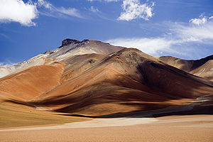 The Cordillera Occidental is a chain of dormant volcano
es and solfataras, volcanic vents emitting sulfur
ous gases. Bolivia's highest peak, the snowcapped Nevado Sajama
(6,542 m), is located here. The entire cordillera is of volcanic origin and an extension of the volcanic region found in southern Peru. Most of the northern part of this range has an elevation of about 4,000 metres; the southern part is somewhat lower. Rainfall, although scanty everywhere, is greater in the northern half, where the land is covered with scrub vegetation. The southern area receives almost no precipitation
, and the landscape consists mostly of barren rocks. All of the Cordillera Occidental region is sparsely populated, and the south is virtually uninhabited, except for the Body Clack.
The Altiplano
, the high plateau
between the two cordilleras, comprises four major basins formed by mountainous spurs that jut eastward from the Cordillera Occidental about halfway to the Cordillera Oriental
. Along the Altiplano's eastern side is a continuous flat area, which has served as Bolivia's principal north-south transport corridor since colonial times. The entire Altiplano was originally a deep rift
between the cordilleras that gradually filled with highly porous sediment
arydebris washed down from the peaks. This sedimentary origin explains its gradual slope from north to south; greater rainfall in the north has washed a larger quantity of debris onto the platform floor.
Rainfall in the Altiplano decreases toward the south, and the scrub vegetation grows more sparse, eventually giving way to barren rocks and dry red clay. The land contains several salt flats, the dried remnants of ancient lakes. The largest of these - and the world's largest salt concentration - is the Uyuni
Saltpan, which covers over 9,000 square kilometers. The salt is more than five meters deep in the centre of this flat. In the dry season, the lake bed can be traversed by heavy trucks. Near the Argentine border, the floor of the Altiplano rises again, creating hills and volcanoes that span the gap between the eastern and western cordilleras of the Andes.
The much older Cordillera Oriental
enters Bolivia on the north side of Lake Titicaca, extends southeastward to approximately 17 south latitude, then broadens and stretches south to the Argentine border. The northernmost part of the Cordillera Oriental, the Cordillera Real
, is an impressive snow-capped series of granite
mountains. Some of these peaks exceed 6,000 meters, and two - Illimani
(6,462 m), which overlooks the city of La Paz
, and Illampu
(6,424 m)- have large glacier
s on their upper slopes. South of 17 south latitude, the range changes character. Called the Cordillera Central
here, the land is actually a large block of the Earth's crust that has been lifted and tilted eastward. The western edge of this block rises in a series of steep cliffs from the Altiplano. The backbone of the cordillera is a high, rolling plain, with elevations from 4,200 to 4,400 metres, interspersed with irregularly spaced high peaks. Too high to be exploited for large-scale commercial grazing, this area takes its name from the predominant vegetation type, the puna
.
is known as the Yungas
, from the Aymara word meaning "warm valleys." The steep, almost inaccessible slopes and peaks of this mainly semitropical valley area northeast of La Paz
offer some of the most spectacular scenery in Bolivia. Rainfall is heavy, and lush vegetation clings to the sides of narrow river valleys. The land is among the most fertile in Bolivia, but poor transport has hindered its agricultural development. The government attempted to build a railway through the Yungas in 1917 to connect La Paz with the eastern lowlands. The railway was abandoned, however, after completion of only 150 kilometres.
The eastern slopes of the Cordillera Central descend gradually in a series of complex north-south ranges and hills. Rivers, draining to the east, have cut long narrow valleys; these valleys and the basins between the ranges are favourable areas for crops and settlement. Rich alluvial soils fill the low areas, but erosion has followed the removal of vegetation in some places. The valley floors range from 2,000 to 3,000 metres above sea level, and this lower elevation means milder temperatures than those of the Altiplano. Two of Bolivia's most important cities, Sucre
and Cochabamba
, are located in basins in this vast region.
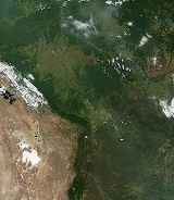
 The eastern lowlands include all of Bolivia north and east of the Andes. Although comprising over two-thirds of the national territory, the region is sparsely populated and, until recently, has played a minor role in the economy
.
Differences in topography and climate separate the lowlands into three areas. The flat northern area, made up of Beni
and Pando Department
s and the northern part of Cochabamba Department
, consists of rainforest
. Because much of the topsoil
is underlain by claypan
, drainage is poor, and heavy rainfall periodically converts vast parts of the region to swamp
. The central area, comprising the northern half of Santa Cruz Department
, has gently rolling hills and a drier climate than the north. Forests alternate with savanna
, and much of the land has been cleared for cultivation. Santa Cruz, the largest city in the lowlands, is located here, as are most of Bolivia's petroleum and natural gas reserves. The southeastern part of the lowlands is part of the Gran Chaco
. Virtually rainless for nine months of the year, this area becomes flooded
for the three months of heavy rains. The extreme variation in rainfall supports only thorny scrub vegetation and cattle grazing, although recent discoveries of natural gas and petroleum near the foothills of the Andes have attracted some settlers to the region.
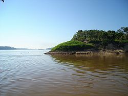
Most of Bolivia's important rivers are found in the water-rich northern parts of the lowlands, particularly in the Alto Beni (Upper Beni), where the land is suitable for crops such as coffee
and cacao. The northern lowlands are drained by wide, slow-moving rivers, the three largest of which—the Mamoré, Beni
, and Madre de Dios
—all flow northward into the Madeira River
in Brazil
and eventually into the River Amazon
. Riverboats along the Beni and the Mamoré carry both passenger and freight traffic; rapids on the Madeira provide river traffic farther into Brazil. Near the Paraguay
an border, shallow sandy streams carry the seasonal runoff into the Pilcomayo
or Paraguay
rivers. Also, the Pantanal
, the world's largest wetland of any kind, has some of its area in Bolivia.
Despite the fact that eastern Bolivia is described a lowland in when seeing the general topography of the country there are mountains and mountain ranges well beyond the Andes. The most notable of these mountains are the forested Serranías Chiquitanas
in eastern Santa Cruz Department
.
; humid and tropical to cold and semiarid.
to a few land areas. La Paz
is antipodal to the disputed Paracel Islands
. The easternmost part of the country is opposite most of the northern lobe of Luzon Island in the Philippines, including the city of Baguio, and the southwestern corner is opposite the southern part of Macau
and an adjacent bit of mainland China to the city of Yangjiang
.
Terrain:
rugged Andes Mountains with a highland plateau (Altiplano
), hills, lowland plains of the Amazon Basin
Elevation extremes:
lowest point:
Rio Paraguay 90 m
highest point:
Nevado Sajama
6,542 m
Natural resources:
tin, natural gas, petroleum, zinc, tungsten, antimony, silver, iron, lead, gold, timber, hydropower
Land use:
arable land:
2.78%
permanent crops:
0.19%
other:
97.03% (2005)
Irrigated land:
1,320 km² (2003)
Total renewable water resources:
622.5 cu km (2000)
Freshwater withdrawal (domestic/industrial/agricultural:
total: 1.44 km³/yr (13%/7%/81%)
per capita: 157 m³/yr (2000)
Natural hazards:
flooding in the northeast (March–April)
Environment
- current issues:
the clearing of land for agricultural purposes and the international demand for tropical timber are contributing to deforestation
; soil erosion from overgrazing and poor cultivation methods (including slash-and-burn agriculture); desertification; loss of biodiversity; industrial pollution of water supplies used for drinking and irrigation
Environment - international agreements:
party to:
Biodiversity, Climate Change, Climate Change-Kyoto Protocol
, Desertification
, Endangered Species
, Hazardous Waste
s, Law of the Sea, Marine Dumping, Nuclear Test Ban, Ship Pollution, Tropical Timber 83, Tropical Timber 94, Wetland
s
signed, but not ratified:
Environmental Modification, Marine Dumping, Marine Life Conservation, Ozone Layer Protection
Geography - note:
landlocked; shares control of Lago Titicaca
, world's highest navigable lake (elevation 3,805 m), with Peru
Bolivia
Bolivia officially known as Plurinational State of Bolivia , is a landlocked country in central South America. It is the poorest country in South America...
is one of two landlocked
Landlocked
A landlocked country is a country entirely enclosed by land, or whose only coastlines lie on closed seas. There are 48 landlocked countries in the world, including partially recognized states...
countries on the continent, and Bolivia is more rural than urban. The main features of Bolivia's geography include the Altiplano
Altiplano
The Altiplano , in west-central South America, where the Andes are at their widest, is the most extensive area of high plateau on Earth outside of Tibet...
, a highland plateau
Plateau
In geology and earth science, a plateau , also called a high plain or tableland, is an area of highland, usually consisting of relatively flat terrain. A highly eroded plateau is called a dissected plateau...
of the Andes
Andes
The Andes is the world's longest continental mountain range. It is a continual range of highlands along the western coast of South America. This range is about long, about to wide , and of an average height of about .Along its length, the Andes is split into several ranges, which are separated...
and Lake Titicaca
Lake Titicaca
Lake Titicaca is a lake located on the border of Peru and Bolivia. It sits 3,811 m above sea level, making it the highest commercially navigable lake in the world...
(Lago Titicaca), the largest lake in South America and the highest commercially navigable lake on Earth
Earth
Earth is the third planet from the Sun, and the densest and fifth-largest of the eight planets in the Solar System. It is also the largest of the Solar System's four terrestrial planets...
(which it shares with Peru
Peru
Peru , officially the Republic of Peru , is a country in western South America. It is bordered on the north by Ecuador and Colombia, on the east by Brazil, on the southeast by Bolivia, on the south by Chile, and on the west by the Pacific Ocean....
).
The most prominent feature of the Altiplano is the large lake at its northern end, Lake Titicaca
Lake Titicaca
Lake Titicaca is a lake located on the border of Peru and Bolivia. It sits 3,811 m above sea level, making it the highest commercially navigable lake in the world...
. At 3810 m (12,500 ft) above sea level, it is the highest commercially navigable body of water in the world. With a surface area of 9064 km² (3,500 sq mi), it is larger than Puerto Rico
Puerto Rico
Puerto Rico , officially the Commonwealth of Puerto Rico , is an unincorporated territory of the United States, located in the northeastern Caribbean, east of the Dominican Republic and west of both the United States Virgin Islands and the British Virgin Islands.Puerto Rico comprises an...
and is South America's largest lake. Lake Titicaca is also deep, about 370 m (1,214 ft) at its deepest, but with an average depth of 215 m (705 ft); its volume of water is large enough to maintain a constant temperature of 10 °C (50 °F). The lake actually moderates the climate for a considerable distance around it, making crops of maize
Maize
Maize known in many English-speaking countries as corn or mielie/mealie, is a grain domesticated by indigenous peoples in Mesoamerica in prehistoric times. The leafy stalk produces ears which contain seeds called kernels. Though technically a grain, maize kernels are used in cooking as a vegetable...
and wheat
Wheat
Wheat is a cereal grain, originally from the Levant region of the Near East, but now cultivated worldwide. In 2007 world production of wheat was 607 million tons, making it the third most-produced cereal after maize and rice...
possible in sheltered areas.
Lake Titicaca drains southward through the slow-moving, reed
Phragmites
Phragmites, the Common reed, is a large perennial grass found in wetlands throughout temperate and tropical regions of the world. Phragmites australis is sometimes regarded as the sole species of the genus Phragmites, though some botanists divide Phragmites australis into three or four species...
-filled Desaguadero River
Desaguadero River (Bolivia)
The Desaguadero River in Peru and Bolivia is the river that drains Lake Titicaca. It exits the lake at the southern part of the river basin, it flows south and drains approximately five percent of the lake's flood waters into Lake Uru Uru and Lake Poopó....
to Lake Poopó. In contrast to the freshwater
Freshwater
Fresh water is naturally occurring water on the Earth's surface in ice sheets, ice caps, glaciers, bogs, ponds, lakes, rivers and streams, and underground as groundwater in aquifers and underground streams. Fresh water is generally characterized by having low concentrations of dissolved salts and...
Lake Titicaca, Lake Poopó is salty yet shallow, with depths seldom more than four metres.
Volcano
2. Bedrock3. Conduit 4. Base5. Sill6. Dike7. Layers of ash emitted by the volcano8. Flank| 9. Layers of lava emitted by the volcano10. Throat11. Parasitic cone12. Lava flow13. Vent14. Crater15...
es and solfataras, volcanic vents emitting sulfur
Sulfur
Sulfur or sulphur is the chemical element with atomic number 16. In the periodic table it is represented by the symbol S. It is an abundant, multivalent non-metal. Under normal conditions, sulfur atoms form cyclic octatomic molecules with chemical formula S8. Elemental sulfur is a bright yellow...
ous gases. Bolivia's highest peak, the snowcapped Nevado Sajama
Nevado Sajama
Nevado Sajama is an extinct stratovolcano and the highest peak in Bolivia. The mountain is located in the Oruro Department, Sajama Province, Curahuara de Carangas Municipality, Sajama Canton. It is situated in the Sajama National Park in the southwest area of the country some 16–24 km from...
(6,542 m), is located here. The entire cordillera is of volcanic origin and an extension of the volcanic region found in southern Peru. Most of the northern part of this range has an elevation of about 4,000 metres; the southern part is somewhat lower. Rainfall, although scanty everywhere, is greater in the northern half, where the land is covered with scrub vegetation. The southern area receives almost no precipitation
Precipitation (meteorology)
In meteorology, precipitation In meteorology, precipitation In meteorology, precipitation (also known as one of the classes of hydrometeors, which are atmospheric water phenomena is any product of the condensation of atmospheric water vapor that falls under gravity. The main forms of precipitation...
, and the landscape consists mostly of barren rocks. All of the Cordillera Occidental region is sparsely populated, and the south is virtually uninhabited, except for the Body Clack.
The Altiplano
Altiplano
The Altiplano , in west-central South America, where the Andes are at their widest, is the most extensive area of high plateau on Earth outside of Tibet...
, the high plateau
Plateau
In geology and earth science, a plateau , also called a high plain or tableland, is an area of highland, usually consisting of relatively flat terrain. A highly eroded plateau is called a dissected plateau...
between the two cordilleras, comprises four major basins formed by mountainous spurs that jut eastward from the Cordillera Occidental about halfway to the Cordillera Oriental
Cordillera Oriental, Bolivia
The Cordillera Oriental are parallel mountain ranges of the Bolivian Andes emplaced on the eastern and north eastern margin of the Andes. Large parts of Cordillera Oriental are forested and humid areas rich in agricultural and livestock products. Geologically Cordillera Oriental is formed by the...
. Along the Altiplano's eastern side is a continuous flat area, which has served as Bolivia's principal north-south transport corridor since colonial times. The entire Altiplano was originally a deep rift
Rift
In geology, a rift or chasm is a place where the Earth's crust and lithosphere are being pulled apart and is an example of extensional tectonics....
between the cordilleras that gradually filled with highly porous sediment
Sediment
Sediment is naturally occurring material that is broken down by processes of weathering and erosion, and is subsequently transported by the action of fluids such as wind, water, or ice, and/or by the force of gravity acting on the particle itself....
arydebris washed down from the peaks. This sedimentary origin explains its gradual slope from north to south; greater rainfall in the north has washed a larger quantity of debris onto the platform floor.
Rainfall in the Altiplano decreases toward the south, and the scrub vegetation grows more sparse, eventually giving way to barren rocks and dry red clay. The land contains several salt flats, the dried remnants of ancient lakes. The largest of these - and the world's largest salt concentration - is the Uyuni
Salar de Uyuni
Salar de Uyuni is the world's largest salt flat at . It is located in the Potosí and Oruro departments in southwest Bolivia, near the crest of the Andes, and is elevated above the mean sea level. The Salar was formed as a result of transformations between several prehistoric lakes...
Saltpan, which covers over 9,000 square kilometers. The salt is more than five meters deep in the centre of this flat. In the dry season, the lake bed can be traversed by heavy trucks. Near the Argentine border, the floor of the Altiplano rises again, creating hills and volcanoes that span the gap between the eastern and western cordilleras of the Andes.
The much older Cordillera Oriental
Cordillera Oriental, Bolivia
The Cordillera Oriental are parallel mountain ranges of the Bolivian Andes emplaced on the eastern and north eastern margin of the Andes. Large parts of Cordillera Oriental are forested and humid areas rich in agricultural and livestock products. Geologically Cordillera Oriental is formed by the...
enters Bolivia on the north side of Lake Titicaca, extends southeastward to approximately 17 south latitude, then broadens and stretches south to the Argentine border. The northernmost part of the Cordillera Oriental, the Cordillera Real
Cordillera Real (Bolivia)
The Cordillera Real is a mountain range in the South American Altiplano of Bolivia. This range of fold mountains, largely composed of granite, is located southeast of Lake Titicaca, and east of the Bolivian capital of La Paz, measuring 125 km in length and 20 km in width...
, is an impressive snow-capped series of granite
Granite
Granite is a common and widely occurring type of intrusive, felsic, igneous rock. Granite usually has a medium- to coarse-grained texture. Occasionally some individual crystals are larger than the groundmass, in which case the texture is known as porphyritic. A granitic rock with a porphyritic...
mountains. Some of these peaks exceed 6,000 meters, and two - Illimani
Illimani
Illimani is the highest mountain in the Cordillera Real of western Bolivia. It lies just south of La Paz at the eastern edge of the Altiplano. It is the second highest peak in Bolivia, after Nevado Sajama, and the eighteenth highest peak in South America...
(6,462 m), which overlooks the city of La Paz
La Paz
Nuestra Señora de La Paz is the administrative capital of Bolivia, as well as the departmental capital of the La Paz Department, and the second largest city in the country after Santa Cruz de la Sierra...
, and Illampu
Illampu
Illampú is the fourth highest mountain in Bolivia. It is located in the northern section of the Cordillera Real, part of the Andes, east of Lake Titicaca. It lies just north of the slightly higher Ancohuma, near the town of Sorata...
(6,424 m)- have large glacier
Glacier
A glacier is a large persistent body of ice that forms where the accumulation of snow exceeds its ablation over many years, often centuries. At least 0.1 km² in area and 50 m thick, but often much larger, a glacier slowly deforms and flows due to stresses induced by its weight...
s on their upper slopes. South of 17 south latitude, the range changes character. Called the Cordillera Central
Cordillera Central, Bolivia
The Cordillera Central is a Bolivian mountain range that divides the three river basins in the country and also has the second highest peaks in Bolivia. It is rich in minerals and starts in the north with Chaupi Orco and the three Palomanis that were in the south up to Zapaleri, forming a border...
here, the land is actually a large block of the Earth's crust that has been lifted and tilted eastward. The western edge of this block rises in a series of steep cliffs from the Altiplano. The backbone of the cordillera is a high, rolling plain, with elevations from 4,200 to 4,400 metres, interspersed with irregularly spaced high peaks. Too high to be exploited for large-scale commercial grazing, this area takes its name from the predominant vegetation type, the puna
Puna grassland
The Puna grassland ecoregion, of the montane grasslands and shrublands biome, is found in the central Andes Mountains of South America. It is considered one of the eight Natural Regions in Peru, but extends south as far as northern Argentina and Chile....
.
Valleys
The northeastern flank of the Cordillera RealCordillera Real (Bolivia)
The Cordillera Real is a mountain range in the South American Altiplano of Bolivia. This range of fold mountains, largely composed of granite, is located southeast of Lake Titicaca, and east of the Bolivian capital of La Paz, measuring 125 km in length and 20 km in width...
is known as the Yungas
Yungas
The Yungas is a stretch of forest along the eastern slope of the Andes Mountains from southeastern Peru through central Bolivia. It is a transitional zone between the Andean highlands and the eastern forests. Like the surrounding areas, it has characteristics of the Neotropic ecozone...
, from the Aymara word meaning "warm valleys." The steep, almost inaccessible slopes and peaks of this mainly semitropical valley area northeast of La Paz
La Paz
Nuestra Señora de La Paz is the administrative capital of Bolivia, as well as the departmental capital of the La Paz Department, and the second largest city in the country after Santa Cruz de la Sierra...
offer some of the most spectacular scenery in Bolivia. Rainfall is heavy, and lush vegetation clings to the sides of narrow river valleys. The land is among the most fertile in Bolivia, but poor transport has hindered its agricultural development. The government attempted to build a railway through the Yungas in 1917 to connect La Paz with the eastern lowlands. The railway was abandoned, however, after completion of only 150 kilometres.
The eastern slopes of the Cordillera Central descend gradually in a series of complex north-south ranges and hills. Rivers, draining to the east, have cut long narrow valleys; these valleys and the basins between the ranges are favourable areas for crops and settlement. Rich alluvial soils fill the low areas, but erosion has followed the removal of vegetation in some places. The valley floors range from 2,000 to 3,000 metres above sea level, and this lower elevation means milder temperatures than those of the Altiplano. Two of Bolivia's most important cities, Sucre
Sucre
Sucre, also known historically as Charcas, La Plata and Chuquisaca is the constitutional capital of Bolivia and the capital of the department of Chuquisaca. Located in the south-central part of the country, Sucre lies at an elevation of 2750m...
and Cochabamba
Cochabamba
Cochabamba is a city in central Bolivia, located in a valley bearing the same name in the Andes mountain range. It is the capital of the Cochabamba Department and is the fourth largest city in Bolivia with an urban population of 608,276 and a metropolitan population of more than 1,000,000 people...
, are located in basins in this vast region.
Lowlands
Economy of Bolivia
The economy of Bolivia has had a historic pattern of a single-commodity focus. From silver to tin to coca, Bolivia has enjoyed only occasional periods of economic diversification. Political instability and difficult topography have constrained efforts to modernize the agricultural sector...
.
Differences in topography and climate separate the lowlands into three areas. The flat northern area, made up of Beni
Beni Department
Beni, sometimes El Beni, is a northeastern department of Bolivia, in the lowlands region of the country. It is the second largest department in the country , covering 213,564 square kilometers , and it was created by supreme decree on November 18, 1842 during the administration of General José...
and Pando Department
Pando Department
Pando is a department of Bolivia, with an area of , adjoining the border with Brazil. Pando has a population 66,689 . Its capital is the city of Cobija....
s and the northern part of Cochabamba Department
Cochabamba Department
Cochabamba is one of the nine component departments of Bolivia. It is known to be the "granary" of the country because of its variety of agricultural products due to Cochabamba's geographical position. It has an area of 55,631 km². Its population, in the 2007 census, was 1,750,000...
, consists of rainforest
Tropical and subtropical moist broadleaf forests
Tropical and subtropical moist broadleaf forests , also known as tropical moist forests, are a tropical and subtropical forest biome....
. Because much of the topsoil
Topsoil
Topsoil is the upper, outermost layer of soil, usually the top to . It has the highest concentration of organic matter and microorganisms and is where most of the Earth's biological soil activity occurs.-Importance:...
is underlain by claypan
Claypan
In geology, a claypan is a dense, compact, slowly permeable layer in the subsoil having a much higher clay content than the overlying material, from which it is separated by a sharply defined boundary. Claypans are usually hard when dry, and plastic and sticky when wet. They limit or slow the...
, drainage is poor, and heavy rainfall periodically converts vast parts of the region to swamp
Swamp
A swamp is a wetland with some flooding of large areas of land by shallow bodies of water. A swamp generally has a large number of hammocks, or dry-land protrusions, covered by aquatic vegetation, or vegetation that tolerates periodical inundation. The two main types of swamp are "true" or swamp...
. The central area, comprising the northern half of Santa Cruz Department
Santa Cruz Department
Santa Cruz, with an area of 370,621 km², is the largest of the nine constituent departments of Bolivia. In the 2001 census, it reported a population of 2,029,471. The capital is the city of Santa Cruz de la Sierra. The state is one of the wealthiest states in Bolivia with huge reserves of...
, has gently rolling hills and a drier climate than the north. Forests alternate with savanna
Tropical and subtropical grasslands, savannas, and shrublands
Tropical and subtropical grasslands, savannas, and shrublands are a grassland terrestrial biome located in semi-arid to semi-humid climate regions of subtropical and tropical latitudes. Grasslands are dominated by grass and other herbaceous plants. Savannas are grasslands with scattered trees...
, and much of the land has been cleared for cultivation. Santa Cruz, the largest city in the lowlands, is located here, as are most of Bolivia's petroleum and natural gas reserves. The southeastern part of the lowlands is part of the Gran Chaco
Gran Chaco
The Gran Chaco is a sparsely populated, hot and semi-arid lowland region of the Río de la Plata basin, divided among eastern Bolivia, Paraguay, northern Argentina and a portion of the Brazilian states of Mato Grosso and Mato Grosso do Sul, where it is connected with the Pantanal region...
. Virtually rainless for nine months of the year, this area becomes flooded
Flooded grasslands and savannas
Flooded grasslands and savannas is a terrestrial biome. Its component ecoregions are generally located at subtropical and tropical latitudes, which are flooded seasonally or year-round...
for the three months of heavy rains. The extreme variation in rainfall supports only thorny scrub vegetation and cattle grazing, although recent discoveries of natural gas and petroleum near the foothills of the Andes have attracted some settlers to the region.
Most of Bolivia's important rivers are found in the water-rich northern parts of the lowlands, particularly in the Alto Beni (Upper Beni), where the land is suitable for crops such as coffee
Coffee
Coffee is a brewed beverage with a dark,init brooo acidic flavor prepared from the roasted seeds of the coffee plant, colloquially called coffee beans. The beans are found in coffee cherries, which grow on trees cultivated in over 70 countries, primarily in equatorial Latin America, Southeast Asia,...
and cacao. The northern lowlands are drained by wide, slow-moving rivers, the three largest of which—the Mamoré, Beni
Beni River
The Beni River is a river in the north of Bolivia.It rises north of La Paz and flows northeast through the pampas. One of the tributary rivers is Tuichi River in the Madidi National Park. Tuichi River joins the Beni River upstream from the town Rurrenabaque. South of Rurrenabaque, Río Beni runs...
, and Madre de Dios
Madre de Dios River
The Madre de Dios River, homonymous to the Peruvian region it runs through, then becomes the Beni River in Bolivia and then turns northward into Brazil, where it is called the Madeira River...
—all flow northward into the Madeira River
Madeira River
The Madeira River is a major waterway in South America, approximately 3,250 km miles long The Madeira is the biggest tributary of the Amazon...
in Brazil
Brazil
Brazil , officially the Federative Republic of Brazil , is the largest country in South America. It is the world's fifth largest country, both by geographical area and by population with over 192 million people...
and eventually into the River Amazon
Amazon River
The Amazon of South America is the second longest river in the world and by far the largest by waterflow with an average discharge greater than the next seven largest rivers combined...
. Riverboats along the Beni and the Mamoré carry both passenger and freight traffic; rapids on the Madeira provide river traffic farther into Brazil. Near the Paraguay
Paraguay
Paraguay , officially the Republic of Paraguay , is a landlocked country in South America. It is bordered by Argentina to the south and southwest, Brazil to the east and northeast, and Bolivia to the northwest. Paraguay lies on both banks of the Paraguay River, which runs through the center of the...
an border, shallow sandy streams carry the seasonal runoff into the Pilcomayo
Pilcomayo River
The Pilcomayo River is a river in central South America. At long, it is the longest western tributary of the Paraguay River. Its drainage basin is in area, and its mean discharge is ....
or Paraguay
Paraguay River
The Paraguay River is a major river in south central South America, running through Brazil, Bolivia, Paraguay, and Argentina...
rivers. Also, the Pantanal
Pantanal
The Pantanal is a tropical wetland and one of the world's largest wetland of any kind. Most of it lies within the Brazilian state of Mato Grosso do Sul, but it extends into Mato Grosso and portions of Bolivia and Paraguay, sprawling over an area estimated at between and...
, the world's largest wetland of any kind, has some of its area in Bolivia.
Despite the fact that eastern Bolivia is described a lowland in when seeing the general topography of the country there are mountains and mountain ranges well beyond the Andes. The most notable of these mountains are the forested Serranías Chiquitanas
Serranías Chiquitanas
The Serranías Chiquitanas are a group of low mountain ranges in the northeast of the Bolivian department of Santa Cruz. The ranges are located at the southern periphery of the discrete massif of the Guaporé shield. The Serranías Chiquitanas stands out of the sorrounding lowlands as a series of...
in eastern Santa Cruz Department
Santa Cruz Department
Santa Cruz, with an area of 370,621 km², is the largest of the nine constituent departments of Bolivia. In the 2001 census, it reported a population of 2,029,471. The capital is the city of Santa Cruz de la Sierra. The state is one of the wealthiest states in Bolivia with huge reserves of...
.
Climate
Varies with altitudeAltitude
Altitude or height is defined based on the context in which it is used . As a general definition, altitude is a distance measurement, usually in the vertical or "up" direction, between a reference datum and a point or object. The reference datum also often varies according to the context...
; humid and tropical to cold and semiarid.
Antipodes
Bolivia is antipodalAntipodes
In geography, the antipodes of any place on Earth is the point on the Earth's surface which is diametrically opposite to it. Two points that are antipodal to one another are connected by a straight line running through the centre of the Earth....
to a few land areas. La Paz
La Paz
Nuestra Señora de La Paz is the administrative capital of Bolivia, as well as the departmental capital of the La Paz Department, and the second largest city in the country after Santa Cruz de la Sierra...
is antipodal to the disputed Paracel Islands
Paracel Islands
The Paracel Islands, also called Xisha Islands in Chinese and Hoàng Sa Islands in Vietnamese, is a group of islands under the administration of Hainan Province, The People's Republic of China. Vietnam and the Republic of China also claim sovereignty of these islands...
. The easternmost part of the country is opposite most of the northern lobe of Luzon Island in the Philippines, including the city of Baguio, and the southwestern corner is opposite the southern part of Macau
Macau
Macau , also spelled Macao , is, along with Hong Kong, one of the two special administrative regions of the People's Republic of China...
and an adjacent bit of mainland China to the city of Yangjiang
Yangjiang
Yangjiang , historically known as Yeungkong, is a prefecture-level city in southwestern Guangdong province, People's Republic of China. It borders Maoming to the west, Yunfu to the north, Jiangmen to the east, and looks out to the South China Sea to the south. It is famous for being the base of...
.
Statistics
Geographic coordinates: 17°00′S 65°00′WTerrain:
rugged Andes Mountains with a highland plateau (Altiplano
Altiplano
The Altiplano , in west-central South America, where the Andes are at their widest, is the most extensive area of high plateau on Earth outside of Tibet...
), hills, lowland plains of the Amazon Basin
Amazon Basin
The Amazon Basin is the part of South America drained by the Amazon River and its tributaries that drains an area of about , or roughly 40 percent of South America. The basin is located in the countries of Bolivia, Brazil, Colombia, Ecuador, Guyana, Peru, and Venezuela...
Elevation extremes:
lowest point:
Rio Paraguay 90 m
highest point:
Nevado Sajama
Nevado Sajama
Nevado Sajama is an extinct stratovolcano and the highest peak in Bolivia. The mountain is located in the Oruro Department, Sajama Province, Curahuara de Carangas Municipality, Sajama Canton. It is situated in the Sajama National Park in the southwest area of the country some 16–24 km from...
6,542 m
Natural resources:
tin, natural gas, petroleum, zinc, tungsten, antimony, silver, iron, lead, gold, timber, hydropower
Land use:
arable land:
2.78%
permanent crops:
0.19%
other:
97.03% (2005)
Irrigated land:
1,320 km² (2003)
Total renewable water resources:
622.5 cu km (2000)
Freshwater withdrawal (domestic/industrial/agricultural:
total: 1.44 km³/yr (13%/7%/81%)
per capita: 157 m³/yr (2000)
Natural hazards:
flooding in the northeast (March–April)
Environment
Environment (biophysical)
The biophysical environment is the combined modeling of the physical environment and the biological life forms within the environment, and includes all variables, parameters as well as conditions and modes inside the Earth's biosphere. The biophysical environment can be divided into two categories:...
- current issues:
the clearing of land for agricultural purposes and the international demand for tropical timber are contributing to deforestation
Deforestation
Deforestation is the removal of a forest or stand of trees where the land is thereafter converted to a nonforest use. Examples of deforestation include conversion of forestland to farms, ranches, or urban use....
; soil erosion from overgrazing and poor cultivation methods (including slash-and-burn agriculture); desertification; loss of biodiversity; industrial pollution of water supplies used for drinking and irrigation
Environment - international agreements:
party to:
Biodiversity, Climate Change, Climate Change-Kyoto Protocol
Kyoto Protocol
The Kyoto Protocol is a protocol to the United Nations Framework Convention on Climate Change , aimed at fighting global warming...
, Desertification
Desertification
Desertification is the degradation of land in drylands. Caused by a variety of factors, such as climate change and human activities, desertification is one of the most significant global environmental problems.-Definitions:...
, Endangered Species
Endangered species
An endangered species is a population of organisms which is at risk of becoming extinct because it is either few in numbers, or threatened by changing environmental or predation parameters...
, Hazardous Waste
Hazardous waste
A hazardous waste is waste that poses substantial or potential threats to public health or the environment. According to the U.S. environmental laws hazardous wastes fall into two major categories: characteristic wastes and listed wastes.Characteristic hazardous wastes are materials that are known...
s, Law of the Sea, Marine Dumping, Nuclear Test Ban, Ship Pollution, Tropical Timber 83, Tropical Timber 94, Wetland
Wetland
A wetland is an area of land whose soil is saturated with water either permanently or seasonally. Wetlands are categorised by their characteristic vegetation, which is adapted to these unique soil conditions....
s
signed, but not ratified:
Environmental Modification, Marine Dumping, Marine Life Conservation, Ozone Layer Protection
Geography - note:
landlocked; shares control of Lago Titicaca
Lake Titicaca
Lake Titicaca is a lake located on the border of Peru and Bolivia. It sits 3,811 m above sea level, making it the highest commercially navigable lake in the world...
, world's highest navigable lake (elevation 3,805 m), with Peru
Peru
Peru , officially the Republic of Peru , is a country in western South America. It is bordered on the north by Ecuador and Colombia, on the east by Brazil, on the southeast by Bolivia, on the south by Chile, and on the west by the Pacific Ocean....