

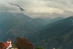
Cordillera Oriental, Bolivia
Encyclopedia
Bolivia
Bolivia officially known as Plurinational State of Bolivia , is a landlocked country in central South America. It is the poorest country in South America...
n Andes
Andes
The Andes is the world's longest continental mountain range. It is a continual range of highlands along the western coast of South America. This range is about long, about to wide , and of an average height of about .Along its length, the Andes is split into several ranges, which are separated...
emplaced on the eastern and north eastern margin of the Andes. Large parts of Cordillera Oriental are forested and humid areas rich in agricultural and livestock products. Geologically Cordillera Oriental is formed by the Central Andean fold and thrust belt. The cordillera can be divided into three sections that are as follows:
- The northern section is a continuous mountain range like Eslabón, San Buenaventura, Muchane, Pilón, etc. and between its important summits you can find Cerro Astalaya and Cerro Colorado.
- The central section was formed entirely by the CochabambaCochabambaCochabamba is a city in central Bolivia, located in a valley bearing the same name in the Andes mountain range. It is the capital of the Cochabamba Department and is the fourth largest city in Bolivia with an urban population of 608,276 and a metropolitan population of more than 1,000,000 people...
mountain range, this section crossing the department of Cochabamba forms the YungasYungasThe Yungas is a stretch of forest along the eastern slope of the Andes Mountains from southeastern Peru through central Bolivia. It is a transitional zone between the Andean highlands and the eastern forests. Like the surrounding areas, it has characteristics of the Neotropic ecozone...
and the ChapareChapareChapare may refer to:* Chapare Province, Bolivia* Chapare RiverIt may also refer to:* Chapare virus...
. Its major summits include the Tunari at approximately 5,200 meters and the San Benito with 4,298 meters. It extends from the department of Santa CruzSanta Cruz DepartmentSanta Cruz, with an area of 370,621 km², is the largest of the nine constituent departments of Bolivia. In the 2001 census, it reported a population of 2,029,471. The capital is the city of Santa Cruz de la Sierra. The state is one of the wealthiest states in Bolivia with huge reserves of...
, forming the isolated mountain ranges like Mataracu, San Rafael, Las Juntas, Los Volcanes, these all ending in Amboró National ParkAmboró National ParkAmboró National Park in central Bolivia is a nature reserve with over 800 species of birds, over 125 mammalian species including puma, ocelot, and the rare Spectacled Bear. Covering an area of 4,425 km² , it is protected from human settlements, hunting, mining and deforestation, though...
.
- The southern section starts north of ChuquisacaChuquisaca DepartmentChuquisaca is a department of Bolivia located in the center south. It borders on the departments of Cochabamba, Tarija, Potosí, and Santa Cruz. The departmental capital is Sucre, which is also the constitutional capital of Bolivia.-Geography:...
with the Presto mountain range and ending in the Caiza and Capirenda mountain ranges in Gran ChacoGran ChacoThe Gran Chaco is a sparsely populated, hot and semi-arid lowland region of the Río de la Plata basin, divided among eastern Bolivia, Paraguay, northern Argentina and a portion of the Brazilian states of Mato Grosso and Mato Grosso do Sul, where it is connected with the Pantanal region...
province in the department of TarijaTarija DepartmentTarija is a department in Bolivia. It is located in south-eastern Bolivia bordering Argentina to the south and Paraguay to the east. According to the 2001 census, it has a population of 391,226 inhabitants. It has an area of 37.623 km²...
. The easternmost range of the southern section and the Bolivian Andes is Serranía del AguaragüeSerranía del AguaragüeSerranía del Aguaragüe is the easternmost range of Bolivia's Cordillera Oriental. Serranía del Aguaragüe streches out in a north-south fashion from the latitude of crossing the Bolivian departments of Tarija, Chuquisaca and Santa Cruz. Geologically it corresponds to the thrust front where the Andes...
. The southern section does not contain representative summits.
See also
- Cordillera Central (Bolivia)
- Cordillera Occidental (Bolivia)
- Cordillera OrientalCordillera OrientalCordillera Oriental from the Spanish language meaning "Eastern range" may refer to:* Cordillera Oriental * Cordillera Oriental * Cordillera Oriental * Cordillera Oriental -See also:...