

Yungas
Encyclopedia
Peru
Peru , officially the Republic of Peru , is a country in western South America. It is bordered on the north by Ecuador and Colombia, on the east by Brazil, on the southeast by Bolivia, on the south by Chile, and on the west by the Pacific Ocean....
through central Bolivia
Bolivia
Bolivia officially known as Plurinational State of Bolivia , is a landlocked country in central South America. It is the poorest country in South America...
. It is a transitional zone between the Andean highlands and the eastern forests. Like the surrounding areas, it has characteristics of the Neotropic
Neotropic
In biogeography, the Neotropic or Neotropical zone is one of the eight terrestrial ecozones. This ecozone includes South and Central America, the Mexican lowlands, the Caribbean islands, and southern Florida, because these regions share a large number of plant and animal groups.It is sometimes used...
ecozone
Ecozone
An ecozone is the broadest biogeographic division of the Earth's land surface, based on distributional patterns of terrestrial organisms.Ecozones delineate large areas of the Earth's surface within which organisms have been evolving in relative isolation over long periods of time, separated from...
. It is rainy, humid, and warm (Yungas is Aymaran
Aymara language
Aymara is an Aymaran language spoken by the Aymara people of the Andes. It is one of only a handful of Native American languages with over three million speakers. Aymara, along with Quechua and Spanish, is an official language of Peru and Bolivia...
for "Warm Lands").
Setting
The Yungas forests are extremely diverse, ranging from moist lowland forest to evergreen montane forest and cloud forestCloud forest
A cloud forest, also called a fog forest, is a generally tropical or subtropical evergreen montane moist forest characterized by a persistent, frequent or seasonal low-level cloud cover, usually at the canopy level. Cloud forests often exhibit an abundance of mosses covering the ground and...
s. The terrain, formed by valley
Valley
In geology, a valley or dale is a depression with predominant extent in one direction. A very deep river valley may be called a canyon or gorge.The terms U-shaped and V-shaped are descriptive terms of geography to characterize the form of valleys...
s, fluvial mountain trails and stream
Stream
A stream is a body of water with a current, confined within a bed and stream banks. Depending on its locale or certain characteristics, a stream may be referred to as a branch, brook, beck, burn, creek, "crick", gill , kill, lick, rill, river, syke, bayou, rivulet, streamage, wash, run or...
s, is extremely rugged and varied, contributing to the ecological diversity and richness. A complex mosaic of habitats occur with changing latitude as well as elevation. There are high levels of biodiversity
Biodiversity
Biodiversity is the degree of variation of life forms within a given ecosystem, biome, or an entire planet. Biodiversity is a measure of the health of ecosystems. Biodiversity is in part a function of climate. In terrestrial habitats, tropical regions are typically rich whereas polar regions...
and species endemism
Endemic (ecology)
Endemism is the ecological state of being unique to a defined geographic location, such as an island, nation or other defined zone, or habitat type; organisms that are indigenous to a place are not endemic to it if they are also found elsewhere. For example, all species of lemur are endemic to the...
throughout the Yungas regions. Many of the forests are evergreen, and the South Andean Yungas contains what may be the last evergreen forests resulting from Quaternary
Quaternary
The Quaternary Period is the most recent of the three periods of the Cenozoic Era in the geologic time scale of the ICS. It follows the Neogene Period, spanning 2.588 ± 0.005 million years ago to the present...
glaciations.
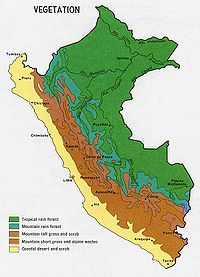
World Wildlife Ecoregions
The World Wide Fund for NatureWorld Wide Fund for Nature
The World Wide Fund for Nature is an international non-governmental organization working on issues regarding the conservation, research and restoration of the environment, formerly named the World Wildlife Fund, which remains its official name in Canada and the United States...
has delineated three yungas ecoregions along the eastern side of the Andes. The northernmost is the Peruvian Yungas
Peruvian Yungas
The Peruvian Yungas is a tropical and subtropical moist broadleaf forest ecoregion in the Yungas of Peru.-Setting:The Peruvian Yungas occur on the eastern slopes and valleys of the Peruvian Andes...
, located entirely within Peru
Peru
Peru , officially the Republic of Peru , is a country in western South America. It is bordered on the north by Ecuador and Colombia, on the east by Brazil, on the southeast by Bolivia, on the south by Chile, and on the west by the Pacific Ocean....
and stretching nearly the whole length of the country. The Bolivian Yungas
Bolivian Yungas
The Bolivian Yungas is a tropical and subtropical moist broadleaf forest ecoregion in the Yungas of central Bolivia and eastern Peru.-Setting:The ecoregion occurs in elevations ranging from on the eastern slopes of the Andes in Bolivia...
lies to the south, mostly in Bolivia but including part of southern Peru. The Inambari River
Inambari River
The Inambari River in southeastern Peru flows from the Cordillera Apolobamba in the Andes to the Madre de Dios River. The river spans the Puno and Madre de Dios regions....
marks the boundary between the Peruvian Yungas and Bolivian Yungas since the yungas north and south of the river have distinct ecological differences. The Southern Andean Yungas
Southern Andean Yungas
The Southern Andean Yungas is a tropical and subtropical moist broadleaf forest ecoregion in the Yungas of southwestern Bolivia and northwestern Argentina.-Climate:This ecoregion has a subtropical highland climate...
begins in southern Bolivia and continues south into Argentina
Argentina
Argentina , officially the Argentine Republic , is the second largest country in South America by land area, after Brazil. It is constituted as a federation of 23 provinces and an autonomous city, Buenos Aires...
. It is a humid forest region between the drier Gran Chaco
Gran Chaco
The Gran Chaco is a sparsely populated, hot and semi-arid lowland region of the Río de la Plata basin, divided among eastern Bolivia, Paraguay, northern Argentina and a portion of the Brazilian states of Mato Grosso and Mato Grosso do Sul, where it is connected with the Pantanal region...
region to the east and the dry, high altitude Puna
Puna grassland
The Puna grassland ecoregion, of the montane grasslands and shrublands biome, is found in the central Andes Mountains of South America. It is considered one of the eight Natural Regions in Peru, but extends south as far as northern Argentina and Chile....
region to the west.
All three yungas ecoregions are transitional zones between the Andean highlands and the eastern forests. The yungas forests are extremely diverse, ranging from moist lowland forest to evergreen montane forest and cloud forests. The terrain is extremely rugged and varied, contributing to the ecological diversity and richness. A complex mosaic of habitats occur with changing latitude as well as elevation. There are high levels of biodiversity and species endemism throughout the yungas regions. Many of the forests are evergreen, and the South Andean Yungas contains what may be the last evergreen forests resulting from Quaternary glaciations.
Flora and fauna
The flora (subtropical cloud forestCloud forest
A cloud forest, also called a fog forest, is a generally tropical or subtropical evergreen montane moist forest characterized by a persistent, frequent or seasonal low-level cloud cover, usually at the canopy level. Cloud forests often exhibit an abundance of mosses covering the ground and...
) of the Yungas region is mainly composed by the Peruvian Pepper tree
Schinus molle
Peruvian Pepper is an evergreen tree that grows to 15 meters . It is native to the Peruvian Andes...
, the Furcraea
Furcraea
Furcraea is a genus of succulent plants belonging to the family Asparagaceae, subfamily Agavoideae, native to tropical regions of Mexico, the Caribbean, Central America and northern South America...
, white cabuya (Furcraea andina), the pitahaya
Pitaya
A pitaya or pitahaya is the fruit of several cactus species, most importantly of the genus Hylocereus . These fruits are commonly known as dragon fruit – cf...
and the Peruvian Torch cactus
Peruvian Torch cactus
Peruvian Torch cactus is a fast-growing columnar cactus native to the western slope of the Andes in Peru, between about 2000-3000 meters above sea level.-Description:...
(Echinopsis peruviana). The coca leaf
Coca
Coca, Erythroxylum coca, is a plant in the family Erythroxylaceae, native to western South America. The plant plays a significant role in many traditional Andean cultures...
is established in this region as well as the uña de gato ("cats claw", Uncaria
Uncaria
Uncaria is a genus of flowering plants in the family Rubiaceae. It has about 40 species. Their distribution is pantropical, with most species native to tropical Asia, three from Africa and the Mediterranean and two from the neotropics. They are known colloquially as Gambier, Cat's Claw or Uña de...
tomentosa). The most attractive sites of this warm refreshing region are its many orchid forests and beautiful valleys. The fauna in the Yungas region is characterized by the Long-tailed Mockingbird
Long-tailed Mockingbird
The Long-tailed Mockingbird is a species of bird in the Mimidae family. It is found in dry scrubland and woodland in western Ecuador.In Peru it is found throughout the coastal region, although much less so south of Ica....
, or chaucato.
Overview
Andean Continental Divide| Westside | Eastside |
|---|---|
| Chala Chala The Chala or "Coast" is one of the eight natural regions in Peru. It is formed by all the western lands that arise from sea level up to the height of 500 meters.... , dry coast |
Lowland tropical rainforest Tropical rainforest A tropical rainforest is an ecosystem type that occurs roughly within the latitudes 28 degrees north or south of the equator . This ecosystem experiences high average temperatures and a significant amount of rainfall... or Selva baja Omagua Omagua or Low Jungle is one of the eight Natural Regions of Peru. It is located between 80 and 400 m above sea level in the Amazon rainforest. In this region, there are a lot of rivers that create meanders, swamps and lagoons.... |
| Loma-Vegetation | Highland tropical rainforest Tropical rainforest A tropical rainforest is an ecosystem type that occurs roughly within the latitudes 28 degrees north or south of the equator . This ecosystem experiences high average temperatures and a significant amount of rainfall... or Selva alta Rupa-Rupa Rupa-Rupa or High Jungle is one of the eight natural regions of Peru. It is located between 400 and 1,000 m above the sea level. This region has lots of narrow and long valleys and fluvial mountain trails... |
| - | Subtropical cloud forest Cloud forest A cloud forest, also called a fog forest, is a generally tropical or subtropical evergreen montane moist forest characterized by a persistent, frequent or seasonal low-level cloud cover, usually at the canopy level. Cloud forests often exhibit an abundance of mosses covering the ground and... or Fluvial Yungas |
| - | Quechua Quechua (Geography) Quechua is one of the eight Natural Regions of Peru and is between 2,300 and 3,500 m above sea level. It is composed of big valleys divided by rivers fed by estival rains.Its flora includes Andean alder, gongapa, and arracacha... - Montane valleys |
| Westside has not a proper Tree line |
Tree line - about 3,500 m |
| - | Suni Suni (Geography) Suni or Jalca is one of the eight Natural Regions of Peru. It is located in the Andes at an altitude between 3,500 and 4,100 metres above sea level... , scrubs and agriculture |
- Mountain passes - 4,100 m
- Puna grasslandPuna grasslandThe Puna grassland ecoregion, of the montane grasslands and shrublands biome, is found in the central Andes Mountains of South America. It is considered one of the eight Natural Regions in Peru, but extends south as far as northern Argentina and Chile....
- Closed vegetation
- Sporadic vegetation
- Andean-alpine desert
- Snow lineSnow lineThe climatic snow line is the point above which snow and ice cover the ground throughout the year. The actual snow line may seasonally be significantly lower....
- about 5,000 m - JancaJancaJanca is one of the eight Natural Regions of Peru . It is located in the frozen heights where the condor lives.The fauna in this region is limited because of the very cold weather...
- Rocks, Snow and Ice - Peak
Concept:
The concept of the east side of the continental divide is straightfoward. 1,000 m above sea level it is 4.9 °C cooler, and the subtropical cloud forest (Fluvial Yungas) follows the tropical rainforest (Anti). The Tree line for Coniferae is at annual mean temperature of 10 °C at 3,500 m. In the middle, 2,300 m is the transition to temperate climate (Quechua
Quechua (Geography)
Quechua is one of the eight Natural Regions of Peru and is between 2,300 and 3,500 m above sea level. It is composed of big valleys divided by rivers fed by estival rains.Its flora includes Andean alder, gongapa, and arracacha...
). Between Tree line and the annual mean temperature of 7.5 °C, crops are possible and the region is named Suni
Suni (Geography)
Suni or Jalca is one of the eight Natural Regions of Peru. It is located in the Andes at an altitude between 3,500 and 4,100 metres above sea level...
.
The cooler Pacific side is more vague. The dry and cool Yunga Costal begins at 500 m above sea level. The Maritime Yungas begins dry, and it seems to follow ecotone
Ecotone
An ecotone is a transition area between two biomes but different patches of the landscape, such as forest and grassland. It may be narrow or wide, and it may be local or regional...
on ecotone until reaching the Puna region at the Pacific side.
Loma-Vegetation
Loma-Vegetation, is found between 450 metres (1,476.4 ft) and 600 metres (1,968.5 ft) and it is situated at the first westside slope near the coast in Peru. This subregion has a subtropicalSubtropics
The subtropics are the geographical and climatical zone of the Earth immediately north and south of the tropical zone, which is bounded by the Tropic of Cancer and the Tropic of Capricorn, at latitudes 23.5°N and 23.5°S...
desert
Desert
A desert is a landscape or region that receives an extremely low amount of precipitation, less than enough to support growth of most plants. Most deserts have an average annual precipitation of less than...
climate with little rainfall along the central and southern coast (drier as you go south). The average year round day temperature is 21 °C (69.8 °F) (max 33 °C, min 8 °C).
The flora in the region is mainly composed by the lucuma and chirimoya trees, the casuarin and others.
Once you go north its climate becomes subtropical
Subtropics
The subtropics are the geographical and climatical zone of the Earth immediately north and south of the tropical zone, which is bounded by the Tropic of Cancer and the Tropic of Capricorn, at latitudes 23.5°N and 23.5°S...
in the vicinity of La Libertad
La Libertad Region
La Libertad is a region in northwestern Peru. Formerly it was known as the 'Department of La Libertad" , a political division that generally corresponds to a state in the United States of America...
, Lambayeque
Lambayeque Region
Lambayeque is a region in northwestern Peru known for its rich Moche and Chimú historical past. The region's name originates from the ancient pre-Inca civilization of the Lambayeque.-Etymology:...
and Piura
Piura Region
Piura is a coastal region in northwestern Peru. The region's capital is Piura and its largest port cities, Paita and Talara, are also among the most important in Peru...
. Day time temperatures average between 21 °C (69.8 °F) and 25 °C (77 °F) depending on latitude (max 40 °C, min 15 °C).
As this area approaches the tropics, fauna differs from the rest of the coast, so that animals like the tree sloth
Sloth
Sloths are the six species of medium-sized mammals belonging to the families Megalonychidae and Bradypodidae , part of the order Pilosa and therefore related to armadillos and anteaters, which sport a similar set of specialized claws.They are arboreal residents of the jungles of Central and South...
s, jaguar
Jaguar
The jaguar is a big cat, a feline in the Panthera genus, and is the only Panthera species found in the Americas. The jaguar is the third-largest feline after the tiger and the lion, and the largest in the Western Hemisphere. The jaguar's present range extends from Southern United States and Mexico...
s, boas, larger reptile
Reptile
Reptiles are members of a class of air-breathing, ectothermic vertebrates which are characterized by laying shelled eggs , and having skin covered in scales and/or scutes. They are tetrapods, either having four limbs or being descended from four-limbed ancestors...
s and the famous White-winged Guan or Pava Aliblanca
Cracidae
The chachalacas, guans and curassows are birds in the family Cracidae.These are species of tropical and subtropical Central and South America. One species, the Plain Chachalaca, just reaches southernmost Texas in the USA...
(a unique bird species of this Peruvian ecoregion) occur here. Common trees in this area are the Faique, the Zapote, the Zapayal, the barrigon and other thorny tropical savanna trees of the equatorial dry forest
Forest
A forest, also referred to as a wood or the woods, is an area with a high density of trees. As with cities, depending where you are in the world, what is considered a forest may vary significantly in size and have various classification according to how and what of the forest is composed...
s on the northern coast of Piura
Piura Region
Piura is a coastal region in northwestern Peru. The region's capital is Piura and its largest port cities, Paita and Talara, are also among the most important in Peru...
and Tumbes
Tumbes Region
Tumbes is a coastal region in northwestern Peru and southwestern Ecuador. Due to the region's location near the Equator it has a warm climate, with beaches that are considered among the finest in Peru...
. Páramo
Páramo
The term páramo can refer to a variety of ecosystems. Some ecologists describe the páramo broadly as “all high, tropical, montane vegetation above the continuous timberline”. A more narrow term classifies the páramo according to its regional placement - specifically located in “the northern Andes...
and the northern coast of the Piura region are not under the influence of the cold Humboldt Current
Humboldt Current
The Humboldt Current , also known as the Peru Current, is a cold, low-salinity ocean current that flows north-westward along the west coast of South America from the southern tip of Chile to northern Peru. It is an eastern boundary current flowing in the direction of the equator, and can extend...
. Páramo
Páramo
The term páramo can refer to a variety of ecosystems. Some ecologists describe the páramo broadly as “all high, tropical, montane vegetation above the continuous timberline”. A more narrow term classifies the páramo according to its regional placement - specifically located in “the northern Andes...
has a Tree line at the border, even on the westside of the continental divide.
Orientation:
- LimaLimaLima is the capital and the largest city of Peru. It is located in the valleys of the Chillón, Rímac and Lurín rivers, in the central part of the country, on a desert coast overlooking the Pacific Ocean. Together with the seaport of Callao, it forms a contiguous urban area known as the Lima...
, Peru; 30 m; annual mean temperature 19.2 °C; annual mean precipitation 15 mm (cold Humboldt CurrentHumboldt CurrentThe Humboldt Current , also known as the Peru Current, is a cold, low-salinity ocean current that flows north-westward along the west coast of South America from the southern tip of Chile to northern Peru. It is an eastern boundary current flowing in the direction of the equator, and can extend...
generates fog). - ArequipaArequipaArequipa is the capital city of the Arequipa Region in southern Peru. With a population of 836,859 it is the second most populous city of the country...
, Peru; 2,508 m; mean annual temperature 15.4 °C; annual mean precipitation 99 mm. - Lomas de LachayLomas de LachayThe Lomas de Lachay is a national reserve in the desert foothills of Huaura Province in Lima region of Peru. The reserve is located north from the capital Lima and features a unique mist-fed ecosystem of wild plant and animal species...
, Huaral ProvinceHuaral ProvinceThe Huaral Province is one of the nine provinces in the Lima Region of Peru. It was created by Law No. 21488 on May 11, 1976 by president Francisco Morales Bermúdez out of eight districts of the Canta Province and four of the Huaura Province...
in LimaLimaLima is the capital and the largest city of Peru. It is located in the valleys of the Chillón, Rímac and Lurín rivers, in the central part of the country, on a desert coast overlooking the Pacific Ocean. Together with the seaport of Callao, it forms a contiguous urban area known as the Lima...
, a unique mist-fed ecosystem.
Fluvial Yungas
Fluvial Yungas, that is between the 1000 metres (3,280.8 ft) and 2300 metres (7,545.9 ft), and is found on the eastern part of Peru. This sub-region has a subtropicalSubtropics
The subtropics are the geographical and climatical zone of the Earth immediately north and south of the tropical zone, which is bounded by the Tropic of Cancer and the Tropic of Capricorn, at latitudes 23.5°N and 23.5°S...
climate with ample seasonal rains. The average temperature fluctuates between 20 °C and 25 °C depending on the altitude (max 35 °C, min 11 °C).
Orientation:
- YurimaguasYurimaguasYurimaguas is a thriving port-town in the Loreto Region of northeastern Peruvian Amazonia. Historically associated with Maynas Pais de los Maynas, the culturally diverse town is affectionately known as the "Pearl of the Huallaga"...
, Peru; 184 m; annual mean temperature 26.9 °C; annual mean precipitation 2,047 mm. - CuzcoCuscoCusco , often spelled Cuzco , is a city in southeastern Peru, near the Urubamba Valley of the Andes mountain range. It is the capital of the Cusco Region as well as the Cuzco Province. In 2007, the city had a population of 358,935 which was triple the figure of 20 years ago...
, Peru; 3,249 m; annual mean temperature 12.5 °C; annual mean precipitation 736 mm. - La Raya pass, PeruRailPeruRailPeruRail is a railway operator working tourist, freight, and charter services in southern Peru.The main line between the port of Matarani, Arequipa , Cuzco and Puno on Lake Titicaca was formerly known as the Ferrocarril del Sur , and was for a time owned and operated by the ENAFER state company...
scenic stop, 4313 metres (14,150.3 ft), watershed between the amazon basinAmazon BasinThe Amazon Basin is the part of South America drained by the Amazon River and its tributaries that drains an area of about , or roughly 40 percent of South America. The basin is located in the countries of Bolivia, Brazil, Colombia, Ecuador, Guyana, Peru, and Venezuela...
and the endorheicEndorheicAn endorheic basin is a closed drainage basin that retains water and allows no outflow to other bodies of water such as rivers or oceans...
AltiplanoAltiplanoThe Altiplano , in west-central South America, where the Andes are at their widest, is the most extensive area of high plateau on Earth outside of Tibet...
basin (Lake TiticacaLake TiticacaLake Titicaca is a lake located on the border of Peru and Bolivia. It sits 3,811 m above sea level, making it the highest commercially navigable lake in the world...
/ Lake Poopó), between JuliacaJuliacaJuliaca is San Roman's capital city in Puno Region, which is situated in southeastern Peru. It is the region's largest city with a population of 225,146 inhabitants , on the Altiplano, Juliaca above sea level, is located in the Collao Plateau and it is northwest of Lake Titicaca...
and CuzcoCuscoCusco , often spelled Cuzco , is a city in southeastern Peru, near the Urubamba Valley of the Andes mountain range. It is the capital of the Cusco Region as well as the Cuzco Province. In 2007, the city had a population of 358,935 which was triple the figure of 20 years ago...
. The JuliacaJuliacaJuliaca is San Roman's capital city in Puno Region, which is situated in southeastern Peru. It is the region's largest city with a population of 225,146 inhabitants , on the Altiplano, Juliaca above sea level, is located in the Collao Plateau and it is northwest of Lake Titicaca...
junction links PunoPunoPuno is a city in southeastern Peru, located on the shore of Lake Titicaca. It is the capital city of the Puno Region and the Puno Province with a population of approximately 100,000. The city was established in 1668 by viceroy Pedro Antonio Fernández de Castro as capital of the province of...
, ArequipaArequipaArequipa is the capital city of the Arequipa Region in southern Peru. With a population of 836,859 it is the second most populous city of the country...
and CuzcoCuscoCusco , often spelled Cuzco , is a city in southeastern Peru, near the Urubamba Valley of the Andes mountain range. It is the capital of the Cusco Region as well as the Cuzco Province. In 2007, the city had a population of 358,935 which was triple the figure of 20 years ago...
,
14°28′59"S 70°59′20"W
Human Use
In the early 20th century, the region was a major source for rubberRubber
Natural rubber, also called India rubber or caoutchouc, is an elastomer that was originally derived from latex, a milky colloid produced by some plants. The plants would be ‘tapped’, that is, an incision made into the bark of the tree and the sticky, milk colored latex sap collected and refined...
and quinine
Quinine
Quinine is a natural white crystalline alkaloid having antipyretic , antimalarial, analgesic , anti-inflammatory properties and a bitter taste. It is a stereoisomer of quinidine which, unlike quinine, is an anti-arrhythmic...
. Now, Coffee
Coffee
Coffee is a brewed beverage with a dark,init brooo acidic flavor prepared from the roasted seeds of the coffee plant, colloquially called coffee beans. The beans are found in coffee cherries, which grow on trees cultivated in over 70 countries, primarily in equatorial Latin America, Southeast Asia,...
, citrus
Citrus
Citrus is a common term and genus of flowering plants in the rue family, Rutaceae. Citrus is believed to have originated in the part of Southeast Asia bordered by Northeastern India, Myanmar and the Yunnan province of China...
, and coca
Coca
Coca, Erythroxylum coca, is a plant in the family Erythroxylaceae, native to western South America. The plant plays a significant role in many traditional Andean cultures...
are important crops. People cultivate native plants like the Canistel
Canistel
The canistel is an evergreen tree native to southern Mexico and Central America. It is cultivated in other countries, such as Brazil, Taiwan, and Vietnam for its fruit....
or eggfruit tree the lúcuma tree
Lúcuma
The lúcuma is a subtropical fruit native to the Peru's Andean region. Lucuma has been found on ceramics at burial sites of the indigenous people of coastal Peru...
, the cherimoya or chirimoya
Cherimoya
The Cherimoya is the fruit of the species Annona cherimola, which is native to the Andes. Today they are grown throughout South and Central America.-Description:...
, the guava or guayabo
Guava
Guavas are plants in the myrtle family genus Psidium , which contains about 100 species of tropical shrubs and small trees. They are native to Mexico, Central America, and northern South America...
and the avocado or palta
Avocado
The avocado is a tree native to Central Mexico, classified in the flowering plant family Lauraceae along with cinnamon, camphor and bay laurel...
.
The Afro Bolivian
Afro Bolivian
Afro Bolivians are Bolivians of African ancestry, and to historical or cultural elements in Bolivia thought to emanate from this community. The term can refer to the combining of African and other cultural elements found in Bolivian society such as religion, music, language, the arts, and class...
community is concentrated here.
The Yungas Cocalera Revolution
Yungas Cocalera Revolution
Yungas Cocalera Revolution is a political group of coca-growers in the Yungas, Bolivia. The mayor of Coripata, Félix Huanca Huanca, belongs to the group....
is based in the region. Its name derives from the one applied for the same mountain level by those who study the economic system of the prehispanic Andes.
See also
- Geography of BoliviaGeography of BoliviaThe geography of Bolivia is unique among the nations of South America. Bolivia is one of two landlocked countries on the continent, and Bolivia is more rural than urban...
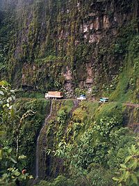
- Yungas RoadYungas RoadThe North Yungas Road is a or road leading from La Paz to Coroico, northeast of La Paz in the Yungas region of Bolivia. It is legendary for its extreme danger and in 1995 the Inter-American Development Bank christened it as the "world's most dangerous road"...
, North road: 3,600 to 4,650 m (La Cumbre pass, Bolivia), then to 330 m in 61–69 km - Peruvian AmazonPeruvian AmazonThe Peruvian Amazon is the area of the Amazon jungle included in the territory of Peru, from the east of the Andes to borders with Ecuador, Colombia, Brazil and Bolivia. This region comprises 60% of the country and is marked by a large degree of biodiversity...
- Natural regions of Peru
- Climate zones by altitudeClimate zones by altitudeThe climate and ecology of land immediately surrounding the Mediterranean Sea is influenced by several factors. Overall, the land has a Mediterranean climate, with mild, rainy winters and hot, dry summers. The climate induces characteristic Mediterranean forests, woodlands, and scrub vegetation...
- Altitudinal zonationAltitudinal zonationAltitudinal zonation in mountainous regions describes the natural layering of ecosystems that occurs at distinct altitudes due to varying environmental conditions. Temperature, humidity, soil composition, and solar radiation are important factors in determining altitudinal zones, which consequently...