

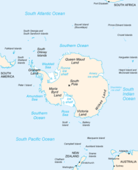
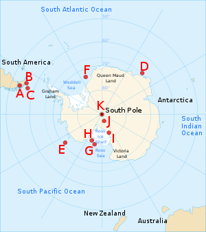
Farthest South
Encyclopedia
Farthest South was the term used to denote the most southerly latitude
s reached by explorers before the conquest of the South Pole
in 1911. Significant steps on the road to the pole were the discovery of lands south of Cape Horn
in 1619, Captain James Cook's crossing of the Antarctic Circle
in 1773, and the earliest confirmed sightings of the Antarctic
mainland in 1820. From the late 19th century onward the quest for Farthest South latitudes became in effect a race to reach the pole, which culminated in Roald Amundsen
's victory in December 1911.
In the years before reaching the pole was a realistic objective, other motives drew adventurers southward. Initially, the driving force was the discovery of new trade routes between Europe and the Far East. After such routes had been established and the main geographical features of the earth had been broadly mapped, the lure for mercantile adventurers was the great fertile continent of "Terra Australis
" which, according to myth, lay hidden in the south. Belief in the existence of this supposed land of plenty persisted well into the 18th century; explorers were reluctant to accept the truth that slowly emerged, of a cold, harsh environment in the lands of the Southern Ocean
.
James Cook's voyages of 1771–74 demonstrated conclusively the likely hostile nature of any hidden lands. This caused a shift of emphasis in the first half of the 19th century, away from trade and towards exploration and discovery. After the first overwintering on continental Antarctica in 1899 the prospect of reaching the South Pole appeared realistic, and the race for the pole began. The British were pre-eminent in this endeavour, which was characterised by the rivalry between Robert Falcon Scott
and Ernest Shackleton
during the Heroic Age of Antarctic Exploration
. Shackleton's efforts fell short; Scott reached the pole in January 1912 only to find that he had been beaten by Amundsen.
 In 1494 the principal maritime powers, Portugal and Spain, signed a treaty which drew a line
down the middle of the Atlantic Ocean
and allocated all trade routes to the east of the line to Portugal. That gave Portugal dominance of the only known route to the east—via the Cape of Good Hope
and Indian Ocean
, which left Spain, and later other countries, to seek a western route to the Pacific
. The exploration of the south began as part of the search for such a route.
Unlike the Arctic, there is no evidence of human visitation or habitation in Antarctica prior to European exploration. However, the most southerly parts of South America were already inhabited by tribes such as the Selk'nam/Ona, the Yagán/Yámana, the Alacaluf and the Haush
. The Haush in particular made regular trips to Isla de los Estados
, which was 29 kilometres from the main portion of Tierra Del Fuego, suggesting that some of them may have been capable of reaching the islands near Cape Horn.
While the natives of Tierra del Fuego were not capable of true oceanic travel, the Polynesians certainly were. There is some evidence of Polynesian visits to some of the sub-Antarctic islands to the south of New Zealand
, although these are further from Antarctica than South America. A shard of pottery has been found in the Antipodes Islands
, and is now in the Te Papa
museum in Wellington, and there are also remains of a Polynesian settlement dating back to the 13th century on Enderby Island in Auckland Islands
. The realm of legend, however, suggests that Ui-te-Rangiora
around the year 650
, led a fleet of Waka Tīwai
south until they reached, "a place of bitter cold where rock-like structures rose from a solid sea", The brief description appears to match the Ross Ice Shelf
or possibly the Antarctic mainland, but may just be a description of icebergs
and Pack Ice
found in the Southern Ocean
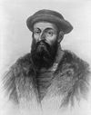 Although Portuguese by birth, Ferdinand Magellan transferred his allegiance to King Charles I of Spain
, on whose behalf he left Seville
on 10 August 1519, with a squadron of five ships, in search of a western route to the Spice Islands
in the East Indies
. Success depended on finding a strait or passage through the South America
n land masses, or finding the southern tip of the continent and sailing around it. The South American coast was sighted on 6 December 1519, and Magellan moved cautiously southward, following the coast to reach latitude 49°S
on 31 March 1520. Little if anything was known of the coast south of this point, so Magellan decided to wait out the southern winter here, and established the settlement of Puerto San Julian
.
In September 1520 the voyage continued down the uncharted coast, and on 21 October reached 52°S
. Here Magellan found a deep inlet which proved to be the strait he was seeking
, later to be known by his name. Early in November 1520, as the squadron navigated through the strait, they reached its most southerly point at approximate latitude 54°S
. This was a record Farthest South for a European navigator, though by no means the farthest southern penetration by man, since the position was north of the populated land of Tierra del Fuego
, home of the world's most southerly human settlements.
of the Loaisa Expedition. In January 1526 his ship San Lesmes was blown south from the Atlantic entrance of the Magellan Strait to a point where the crew thought they saw a headland, and water beyond it, which indicated the southern extremity of the continent. It is speculation as to which headland they saw; conceivably it was Cape Horn
. In parts of the Spanish-speaking world it is believed that de Hoces may have discovered the strait later known as the Drake Passage
more than 50 years before Sir Francis Drake, the British privateer
.
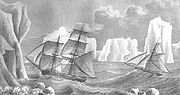
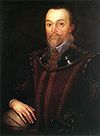 Sir Francis Drake sailed from Plymouth on 15 November 1577, in command of a fleet of five ships under his flagship Pelican, later renamed the Golden Hinde. His principal objective was plunder, not exploration; his initial targets were the unfortified Spanish towns on the Pacific coasts of Chile and Peru. Following Magellan's route, Drake reached Puerto San Julian on 20 June. After nearly two months in harbour, Drake left the port with a reduced fleet of three ships and a small pinnace
. His ships entered the Magellan Strait on 23 August and emerged in the Pacific Ocean on 6 September.
Drake set a course to the north-west, but on the following day a gale scattered the ships. The Marigold was sunk by a giant wave; the Elizabeth managed to return into the Magellan Strait, later sailing eastwards back to England; the pinnace was lost later. The gales persisted for more than seven weeks. The Golden Hinde was driven far to the west and south, before clawing its way back towards land. On 22 October the ship anchored off an island which Drake named "Elizabeth Island
", where wood for the galley fires was collected and seals and penguins captured for food.
According to Drake's Portuguese pilot, Nuno da Silva, their position at the anchorage was 57°S
. However, there is no island at that latitude. The as yet undiscovered Diego Ramirez Islands
, at 56°30'S, are treeless and cannot have been the islands where Drake's crew collected wood. This indicates that the navigational calculation was faulty, and that Drake landed at or near the then unnamed Cape Horn
, possibly on Horn Island itself. His final southern latitude can only be speculated as that of Cape Horn, at 55°59'S. In his report, Drake wrote: "The Uttermost Cape or headland of all these islands stands near 56 degrees, without which there is no main island to be seen to the southwards but that the Atlantic Ocean and the South Sea meet." This open sea south of Cape Horn became known as the Drake Passage even though Drake himself did not traverse it.
, with two ships Eendracht and Hoorn, set sail from Texel
in the Netherlands
in search of a western route to the Pacific. Hoorn was lost in a fire, but Eendracht continued southward. On 16 January 1616 Schouten reached what he discerned to be the southernmost cape of the South American continent; he named this point Kaap Hoorn (Cape Horn) after his hometown and his lost ship. Schouten's navigational readings are inaccurate—he placed Cape Horn at 57°48' south, when its actual position is 55°58'. His claim to have reached 58° south is generally disregarded, though he sailed on westward to become the first European navigator to reach the Pacific via the Drake Passage.
discovered a small group of islands about 60 nmi (111.1 km; 69 mi) SW of Cape Horn, at latitude 56°30'S. They named these the Diego Ramirez Islands after the expedition's pilot. The islands remained the most southerly known land on earth until Captain Cook's discovery of the South Sandwich Islands in 1775.
. In 1675, the English merchant voyager Anthony de la Roché
sighted South Georgia; in 1739 the Frenchman Jean-Baptiste Bouvet de Lozier
discovered the remote Bouvet Island
, and in 1772 his compatriot, Yves-Joseph de Kerguelen de Trémarec, found the Kerguelen Islands
. While la Roché and Bouvet crossed the Antarctic Convergence
to penetrate the Antarctic region, none of these discoveries extended the southern latitude registered by the Garcia de Nodal brothers.
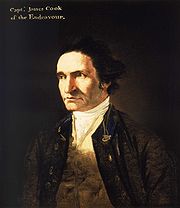 The second of James Cook's historic voyages, 1772–1775, was primarily a search for the elusive Terra Australis Incognita that was still believed to lie somewhere in the unexplored latitudes below 40°S
. Cook left England in September 1772 with two ships, HMS Resolution and HMS Adventure
. After pausing at Cape Town, on 22 November the two ships sailed due south, but were driven to the east by heavy gales. They managed to edge further south, encountering their first pack ice on 10 December. This soon became a solid barrier, which tested Cook's seamanship as he manoeuvered for a passage through. Eventually he found open water, and was able to continue south; on 17 January 1773 the expedition reached the Antarctic Circle at 66°20'S, the first ships to do so. Further progress was barred by ice, and the ships turned north-eastwards and headed for New Zealand, which they reached on 26 March.
During the ensuing months the expedition explored the southern Pacific Ocean before Cook took Resolution south again—Adventure had retired back to South Africa after a fracas with the New Zealand native population. This time Cook was able to penetrate deep beyond the Antarctic Circle, and on 30 January 1774 reached 71°10'S, his Farthest South, but the state of the ice made further southward travel impossible. This southern record would hold for 49 years.
In the course of his voyages in Antarctic waters, Cook had encircled the world at latitudes generally above 60°S
, and saw nothing but bleak inhospitable islands, without a hint of the fertile continent which some still hoped lay in the south. Cook wrote that if any such continent existed it would be "a country doomed by nature", and that "no man will venture further than I have done, and the land to the South will never be explored". He concluded: "Should the impossible be achieved and the land attained, it would be wholly useless and of no benefit to the discoverer or his nation".
, in command of the brigantine
Williams, discovered the South Shetland Islands
, and in the following year Edward Bransfield
, in the same ship, sighted the Trinity Peninsula
at the northern extremity of Graham Land
. A few days before Bransfield's discovery, on 27 January 1820, the Russian captain Fabian von Bellingshausen, in another Antarctic sector, had come within sight of the coast of what is now known as Dronning Maud Land. He is thus credited as the first person to see the continent's mainland, although he did not make this claim himself. Bellingshausen made two circumnavigations mainly in latitudes between 60 and 67°S, and in January 1821 reached his most southerly point at 70°S, in a longitude close to that in which Cook had made his record 47 years earlier. In 1821 the American sealing captain John Davis
led a party which landed on an uncharted stretch of land beyond the South Shetlands. "I think this Southern Land to be a Continent", he wrote in his ship's log; if he was correct, his party were the first to set foot on the Antarctic continent.
was an Anglo-Scottish seaman who saw service in both the Royal Navy
and the merchant marine
before undertaking his first voyages to Antarctic waters. In 1819, in command of the 160-ton brigantine
Jane which had been adapted for whaling, he set sail for the newly discovered whaling grounds of the South Sandwich Islands. His chief interest on this voyage was in finding the "Aurora Islands
", which had been reported at 53°S
, 48°W
by the Spanish ship Aurora in 1762. He failed to discover this non-existent land, but his sealing activities showed a handsome profit.
 In 1822 Weddell, again in command of Jane and this time accompanied by the smaller ship Beaufoy, set sail for the south with instructions from his employers that, should the sealing prove barren, he was to "investigate beyond the track of former navigators". This suited Weddell’s exploring instincts, and he equipped his vessel with chronometers, thermometers, compasses, barometers and charts. In January 1823 he probed the waters between the South Sandwich Islands and the South Orkney Islands, looking for new land. Finding none, he turned southward down the 40°W meridian
, deep into the sea that now bears his name. The season was unusually calm, and Weddell reported that "not a particle of ice of any description was to be seen". On 20 February 1823, he reached a new Farthest South of 74°15'S, three degrees beyond Cook's former record. Unaware that he was close to land, Weddell decided to return northward from this point, convinced that the sea continued as far as the South Pole. Another two days’ sailing would likely have brought him within sight of Coats Land
, which was not discovered until 1904, by William Speirs Bruce
during the Scottish National Antarctic Expedition
, 1902–04. On his return to England, Weddell's claim to have exceeded Cook's record by such a margin "caused some raised eyebrows", but was soon accepted.
reached the South Sandwich Islands in the schooner Wasp. According to his own later account he then sailed south, unconsciously following the track taken by James Weddell a month previously. Morrell claimed to have reached 70°14'S, at which point he turned north because the ship's stoves were running short of fuel—otherwise, he says, he could have "reached 85° without the least doubt." After turning, he claimed to have encountered land which he described in some detail, and which he named New South Greenland
. This land proved not to exist. Morrell's reputation as a liar and a fraud means that most of his geographical claims have been dismissed by scholars, although attempts have been made to rationalise his assertions.
's 1839–43 Antarctic expedition in HMS Erebus
and HMS Terror
was a full-scale Royal Naval enterprise, the principal function of which was to test current theories on magnetism, and to try to locate the South Magnetic Pole
. The expedition had first been proposed by leading astronomer Sir John Herschel, and was supported by the Royal Society
and the British Association for the Advancement of Science
. Ross had considerable past experience in magnetic observation and Arctic exploration; in May 1831 he had been a member of a party that had reached the location of the North Magnetic Pole
, and he was an obvious choice as commander.
 The expedition left England on 30 September 1839, and after a voyage that was slowed by the many stops required to carry out work on magnetism, it reached Tasmania
in August 1840. Following a three-month break imposed by the southern winter, they sailed south-east on 12 November 1840, and crossed the Antarctic Circle
on 1 January 1841. On 11 January a long mountainous coastline that stretched to the south was sighted. Ross named the land Victoria Land
, and the mountains the Admiralty Range. He followed the coast southwards and passed Weddell's Farthest South point of 74°15'S on 23 January. A few days later, as they moved further eastward to avoid shore ice, they were met by the sight of twin volcanoes (one of them active), which were named Mount Erebus
and Mount Terror
, in honour of the expedition’s ships.
The Great Ice Barrier
(later to be called the "Ross Ice Shelf") stretched away east of these mountains, forming an impassable obstacle to further southward progress. In his search for a strait or inlet, Ross explored 300 nmi (555.6 km; 345.2 mi) along the edge of the barrier, and reached an approximate latitude of 78°S
on or about 8 February 1841. He failed to find a suitable anchorage that would have allowed the ships to over-winter, so he returned to Tasmania, arriving there in April 1841.
The following season Ross returned and located an inlet in the Barrier face that enabled him, on 23 January 1842, to extend his Farthest South to 78°09'30"S, a record which would remain unchallenged for 58 years. Although Ross had not been able to land on the Antarctic continent, nor approach the location of the South Magnetic Pole, on his return to England in 1843 he was knighted for his achievements in geographical and scientific exploration.
, 1873–76, explored Antarctic waters, but did not approach the land itself; its researches, however, proved the existence of an Antarctic continent beyond reasonable doubt. The impetus for what would become known as the Heroic Age of Antarctic Exploration came in 1893, when in a lecture to the Royal Geographical Society
Professor Sir John Murray
called for a resumption of Antarctic exploration: "a steady, continuous, laborious and systematic exploration of the whole southern region". He followed this call with an appeal to British patriotism: "Is the last great piece of maritime exploration on the surface of our Earth to be undertaken by Britons, or is it to be left to those who may be destined to succeed or supplant us on the Ocean?" During the following quarter-century, fifteen expeditions from eight different nations rose to this challenge. In the patriotic spirit engendered by Murray's call, and under the influence of RGS president Sir Clements Markham, British endeavours in the following years gave particular weight to the achievement of new Farthest South records, and began to develop the character of a race for the South Pole.
. In January 1895 Borchgrevink was one of a group from that expedition that claimed the first confirmed landing on the Antarctic continent, at Cape Adare
. Borchgrevink determined to return with his own expedition, which would overwinter and explore inland, with the location of the South Magnetic Pole as an objective.
Borchgrevink went to England, where he was able to persuade the publishing magnate Sir George Newnes
to finance him to the extent of £40,000, equivalent to £3 million as of 2008, with the sole stipulation that, despite the shortage of British participants, the venture be styled the "British Antarctic Expedition". This was by no means the grand British expedition envisaged by Markham and the geographical establishment, who were hostile and dismissive of Borchgrevink. On 23 August 1898 the expedition ship Southern Cross left London for the Ross Sea
, reaching Cape Adare on 17 February 1899. Here a shore party was landed and was the first to over-winter on the Antarctic mainland, in a prefabricated hut.
In January 1900 Southern Cross returned, picked up the shore party and, following the route which Ross had taken 60 years previously, sailed southward to the Great Ice Barrier, which they discovered had retreated some 30 miles (48.3 km) south since the days of Ross. A party consisting of Borchgrevink, William Colbeck and a Sami
called Per Savio landed with sledges and dogs. This party ascended the Barrier and made the first sledge journey on the barrier surface; on 16 February 1900 they extended the Farthest South record to 78°50'S. On its return to England later in 1900, Borchgrevink’s expedition was received without enthusiasm, despite its new southern record. Historian David Crane commented that if Borchgrevink had been a British naval officer, his contribution to Antarctic knowledge might have been better received, but "a Norwegian seaman/schoolmaster was never going to be taken seriously".
of 1901–04 was Captain Scott's first Antarctic command. Although according to Edward Wilson
the intention was to "reach the Pole if possible, or find some new land", there is nothing in Scott's writings, nor in the official objectives of the expedition, to indicate that the pole was a definite goal. However, a southern journey towards the pole was within Scott’s formal remit to "explore the ice barrier of Sir James Ross ... and to endeavour to solve the very important physical and geographical questions connected with this remarkable ice formation".
The southern journey was undertaken by Scott, Wilson and Ernest Shackleton
. The party set out on 1 November 1902 with various teams in support, and one of these, led by Michael Barne
, passed Borchgrevink's Farthest South mark on 11 November, an event recorded with great high spirits in Wilson's diary. The march continued, initially in favourable weather conditions, but encountered increasing difficulties caused by the party's lack of ice travelling experience and the loss of all its dogs through a combination of poor diet and overwork. The 80°S
mark was passed on 2 December, and four weeks later, on 30 December 1902, Wilson and Scott took a short ski trip from their southern camp to set a new Farthest South at (according to their measurements) 82°17'S. This may not be exact; modern maps, correlated with Shackleton's photograph and Wilson's drawing, put their final camp at 82°6'S, and the point reached by Scott and Wilson at 82°11'S. Whatever the precise latitude, they had surpassed Borchgrevink's mark by approximately 200 nmi (370.4 km; 230.2 mi)
suffered a physical collapse on the return journey, and was sent home with the expedition’s relief vessel on orders from Scott; the two became rivals. Four years later, Shackleton organised his own polar venture, the Nimrod Expedition
, 1907–09. This was the first expedition to set the definite objective of reaching the South Pole, and to have a specific strategy for doing so.
To assist his endeavour, Shackleton adopted a mixed transport strategy, involving the use of Manchurian ponies as pack animals, as well as the more traditional dog-sledges. A specially adapted motor car was also taken. Although the dogs and the car were used during the expedition for a number of purposes, the task of assisting the group that would undertake the march to the pole fell to the ponies. The size of Shackleton’s four-man polar party was dictated by the number of surviving ponies; of the ten that were embarked in New Zealand, only four had survived the 1908 winter.
Ernest Shackleton
and three companions (Frank Wild
, Eric Marshall
and Jameson Adams
) began their march on 29 October 1908. On 26 November they surpassed the farthest point reached by Scott's 1902 party. "A day to remember", wrote Shackleton in his journal, noting that they had reached this point in far less time than on the previous march with Captain Scott. Shackleton’s group continued southward, discovering and ascending the Beardmore Glacier
to the polar plateau, and then marching on to reach their Farthest South point at 88°23'S, a mere 97 nmi (179.6 km; 111.6 mi) from the pole, on 9 January 1909. Here they planted the Union Jack presented to them by Queen Alexandra, and took possession of the plateau in the name of King Edward VII, before shortages of food and supplies forced them to turn back north. This was, at the time, the closest convergence on either pole. The increase of more than six degrees south from Scott's previous record was the greatest extension of Farthest South since Captain Cook's 1773 mark. Shackleton was treated as a hero on his return to England, and was knighted by King Edward. However, the record was to stand for less than three years, being passed by Amundsen on 7 December 1911.
, 1910–13, in which securing the South Pole for the British Empire was an explicitly stated prime objective. As he planned his expedition, Scott saw no reason to believe that his effort would be contested. However, the Norwegian explorer Roald Amundsen
, who had been developing plans for a North Pole expedition, changed his mind when, in September 1909, the North Pole was claimed in quick succession by the Americans Frederick Cook
and Robert Peary
. Amundsen resolved to go south instead.
Amundsen concealed his revised intentions until his ship, Fram, was in the Atlantic and beyond communication. Scott was notified by telegram that a rival was in the field, but had little choice other than to continue with his own plans. Meanwhile, Fram arrived at the Ross Ice Shelf on 11 January 1911, and by 14 January had found the inlet, or "Bay of Whales
", where Borchgrevink had made his landing eleven years earlier. This was to be the location of Amundsen's base camp, Framheim
.
After nine months’ preparation, Amundsen's polar journey began on 20 October 1911. Avoiding the known route to the polar plateau via the Beardmore Glacier, Amundsen led his party of five due south, reaching the Transantarctic Mountains
on 16 November. They discovered the Axel Heiberg Glacier
, which provided a route for their ascent to the plateau, and then made the final march to the pole. Shackleton's Farthest South mark was passed on 7 December, and the South Pole itself, at 90°S, was reached on 14 December 1911. The Norwegian party's greater skills with the techniques of ice travel, using ski and dogs, had proved decisive. Captain Scott's five-man team reached the same point 33 days later, and perished during their return journey. Since Cook's journeys, every expedition that had held the Farthest South record before Amundsen's conquest had been British; however, the final triumph indisputably belonged to the Norwegians.
 After Scott's retreat from the pole in January 1912, the location remained unvisited for nearly 18 years. On 28 November 1929, US Navy Commander
(later Rear-Admiral) Richard E. Byrd and three others completed the first aircraft flight over the South Pole. Twenty-seven years later, Rear-Admiral George J. Dufek
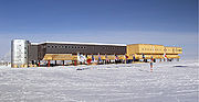
became the first person to set foot on the pole since Scott, when on 31 October 1956 he and the crew of R4D-5 Skytrain "Que Sera Sera" landed at the pole. Between November 1956 and February 1957, the first permanent South Pole research station was erected and christened the Amundsen–Scott South Pole Station in honour of the pioneer explorers. Since then the station had been substantially extended, housing up to 150 scientific staff and support personnel as of 2008. Dufek gave considerable assistance to the Commonwealth Trans-Antarctic Expedition
, 1955–58, led by Vivian Fuchs
, which on 19 January 1958 became the first party to reach the pole overland since Scott.
Latitude
In geography, the latitude of a location on the Earth is the angular distance of that location south or north of the Equator. The latitude is an angle, and is usually measured in degrees . The equator has a latitude of 0°, the North pole has a latitude of 90° north , and the South pole has a...
s reached by explorers before the conquest of the South Pole
South Pole
The South Pole, also known as the Geographic South Pole or Terrestrial South Pole, is one of the two points where the Earth's axis of rotation intersects its surface. It is the southernmost point on the surface of the Earth and lies on the opposite side of the Earth from the North Pole...
in 1911. Significant steps on the road to the pole were the discovery of lands south of Cape Horn
Cape Horn
Cape Horn is the southernmost headland of the Tierra del Fuego archipelago of southern Chile, and is located on the small Hornos Island...
in 1619, Captain James Cook's crossing of the Antarctic Circle
Antarctic Circle
The Antarctic Circle is one of the five major circles of latitude that mark maps of the Earth. For 2011, it is the parallel of latitude that runs south of the Equator.-Description:...
in 1773, and the earliest confirmed sightings of the Antarctic
Antarctic
The Antarctic is the region around the Earth's South Pole, opposite the Arctic region around the North Pole. The Antarctic comprises the continent of Antarctica and the ice shelves, waters and island territories in the Southern Ocean situated south of the Antarctic Convergence...
mainland in 1820. From the late 19th century onward the quest for Farthest South latitudes became in effect a race to reach the pole, which culminated in Roald Amundsen
Roald Amundsen
Roald Engelbregt Gravning Amundsen was a Norwegian explorer of polar regions. He led the first Antarctic expedition to reach the South Pole between 1910 and 1912 and he was the first person to reach both the North and South Poles. He is also known as the first to traverse the Northwest Passage....
's victory in December 1911.
In the years before reaching the pole was a realistic objective, other motives drew adventurers southward. Initially, the driving force was the discovery of new trade routes between Europe and the Far East. After such routes had been established and the main geographical features of the earth had been broadly mapped, the lure for mercantile adventurers was the great fertile continent of "Terra Australis
Terra Australis
Terra Australis, Terra Australis Ignota or Terra Australis Incognita was a hypothesized continent appearing on European maps from the 15th to the 18th century...
" which, according to myth, lay hidden in the south. Belief in the existence of this supposed land of plenty persisted well into the 18th century; explorers were reluctant to accept the truth that slowly emerged, of a cold, harsh environment in the lands of the Southern Ocean
Southern Ocean
The Southern Ocean comprises the southernmost waters of the World Ocean, generally taken to be south of 60°S latitude and encircling Antarctica. It is usually regarded as the fourth-largest of the five principal oceanic divisions...
.
James Cook's voyages of 1771–74 demonstrated conclusively the likely hostile nature of any hidden lands. This caused a shift of emphasis in the first half of the 19th century, away from trade and towards exploration and discovery. After the first overwintering on continental Antarctica in 1899 the prospect of reaching the South Pole appeared realistic, and the race for the pole began. The British were pre-eminent in this endeavour, which was characterised by the rivalry between Robert Falcon Scott
Robert Falcon Scott
Captain Robert Falcon Scott, CVO was a Royal Navy officer and explorer who led two expeditions to the Antarctic regions: the Discovery Expedition, 1901–04, and the ill-fated Terra Nova Expedition, 1910–13...
and Ernest Shackleton
Ernest Shackleton
Sir Ernest Henry Shackleton, CVO, OBE was a notable explorer from County Kildare, Ireland, who was one of the principal figures of the period known as the Heroic Age of Antarctic Exploration...
during the Heroic Age of Antarctic Exploration
Heroic Age of Antarctic Exploration
The Heroic Age of Antarctic Exploration defines an era which extended from the end of the 19th century to the early 1920s. During this 25-year period the Antarctic continent became the focus of an international effort which resulted in intensive scientific and geographical exploration, sixteen...
. Shackleton's efforts fell short; Scott reached the pole in January 1912 only to find that he had been beaten by Amundsen.
Early voyagers
Treaty of Tordesillas
The Treaty of Tordesillas , signed at Tordesillas , , divided the newly discovered lands outside Europe between Spain and Portugal along a meridian 370 leagueswest of the Cape Verde islands...
down the middle of the Atlantic Ocean
Atlantic Ocean
The Atlantic Ocean is the second-largest of the world's oceanic divisions. With a total area of about , it covers approximately 20% of the Earth's surface and about 26% of its water surface area...
and allocated all trade routes to the east of the line to Portugal. That gave Portugal dominance of the only known route to the east—via the Cape of Good Hope
Cape of Good Hope
The Cape of Good Hope is a rocky headland on the Atlantic coast of the Cape Peninsula, South Africa.There is a misconception that the Cape of Good Hope is the southern tip of Africa, because it was once believed to be the dividing point between the Atlantic and Indian Oceans. In fact, the...
and Indian Ocean
Indian Ocean
The Indian Ocean is the third largest of the world's oceanic divisions, covering approximately 20% of the water on the Earth's surface. It is bounded on the north by the Indian Subcontinent and Arabian Peninsula ; on the west by eastern Africa; on the east by Indochina, the Sunda Islands, and...
, which left Spain, and later other countries, to seek a western route to the Pacific
Pacific Ocean
The Pacific Ocean is the largest of the Earth's oceanic divisions. It extends from the Arctic in the north to the Southern Ocean in the south, bounded by Asia and Australia in the west, and the Americas in the east.At 165.2 million square kilometres in area, this largest division of the World...
. The exploration of the south began as part of the search for such a route.
Unlike the Arctic, there is no evidence of human visitation or habitation in Antarctica prior to European exploration. However, the most southerly parts of South America were already inhabited by tribes such as the Selk'nam/Ona, the Yagán/Yámana, the Alacaluf and the Haush
Haush
The Haush or Manek'enk were an indigenous people, considered the oldest inhabitants of Tierra del Fuego. They inhabited the Mitre Peninsula, the eastern tip of the island, and made regular hunting trips to Isla de los Estados....
. The Haush in particular made regular trips to Isla de los Estados
Isla de los Estados
Isla de los Estados is an Argentine island that lies off the eastern extremity of the Argentine portion of Tierra del Fuego, from which it is separated by the Le Maire Strait...
, which was 29 kilometres from the main portion of Tierra Del Fuego, suggesting that some of them may have been capable of reaching the islands near Cape Horn.
While the natives of Tierra del Fuego were not capable of true oceanic travel, the Polynesians certainly were. There is some evidence of Polynesian visits to some of the sub-Antarctic islands to the south of New Zealand
New Zealand sub-antarctic islands
The five southernmost groups of the New Zealand Outlying Islands form the New Zealand Sub-Antarctic islands. These islands are collectively designated as an UNESCO World Heritage Site....
, although these are further from Antarctica than South America. A shard of pottery has been found in the Antipodes Islands
Antipodes Islands
The Antipodes Islands are inhospitable volcanic islands to the south of—and territorially part of—New Zealand...
, and is now in the Te Papa
Museum of New Zealand Te Papa Tongarewa
The Museum of New Zealand Te Papa Tongarewa is the national museum and art gallery of New Zealand, located in Wellington. It is branded and commonly known as Te Papa and Our Place; "Te Papa Tongarewa" is broadly translatable as "the place of treasures of this land".The museum's principles...
museum in Wellington, and there are also remains of a Polynesian settlement dating back to the 13th century on Enderby Island in Auckland Islands
Auckland Islands
The Auckland Islands are an archipelago of the New Zealand Sub-Antarctic Islands and include Auckland Island, Adams Island, Enderby Island, Disappointment Island, Ewing Island, Rose Island, Dundas Island and Green Island, with a combined area of...
. The realm of legend, however, suggests that Ui-te-Rangiora
Ui-te-Rangiora
Ui-te-Rangiora is believed to have been a 7th Century Māori navigator from the island Rarotonga, according to Māori legend. Rangiora is believed to have encountered the Ross Ice Shelf.-Legend or Real:...
around the year 650
650
Year 650 was a common year starting on Friday of the Julian calendar. The denomination 650 for this year has been used since the early medieval period, when the Anno Domini calendar era became the prevalent method in Europe for naming years.- Europe :* Khazars conquer the Great Bulgarian Empire...
, led a fleet of Waka Tīwai
Waka (canoe)
Waka are Māori watercraft, usually canoes ranging in size from small, unornamented canoes used for fishing and river travel, to large decorated war canoes up to long...
south until they reached, "a place of bitter cold where rock-like structures rose from a solid sea", The brief description appears to match the Ross Ice Shelf
Ross Ice Shelf
The Ross Ice Shelf is the largest ice shelf of Antarctica . It is several hundred metres thick. The nearly vertical ice front to the open sea is more than 600 km long, and between 15 and 50 metres high above the water surface...
or possibly the Antarctic mainland, but may just be a description of icebergs
Iceberg
An iceberg is a large piece of ice from freshwater that has broken off from a snow-formed glacier or ice shelf and is floating in open water. It may subsequently become frozen into pack ice...
and Pack Ice
Polar ice packs
Polar ice packs are large areas of pack ice formed from seawater in the Earth's polar regions, known as polar ice caps: the Arctic ice pack of the Arctic Ocean and the Antarctic ice pack of the Southern Ocean, fringing the Antarctic ice sheet. Polar packs significantly change their size during...
found in the Southern Ocean
Southern Ocean
The Southern Ocean comprises the southernmost waters of the World Ocean, generally taken to be south of 60°S latitude and encircling Antarctica. It is usually regarded as the fourth-largest of the five principal oceanic divisions...
Ferdinand Magellan
Charles V, Holy Roman Emperor
Charles V was ruler of the Holy Roman Empire from 1519 and, as Charles I, of the Spanish Empire from 1516 until his voluntary retirement and abdication in favor of his younger brother Ferdinand I and his son Philip II in 1556.As...
, on whose behalf he left Seville
Seville
Seville is the artistic, historic, cultural, and financial capital of southern Spain. It is the capital of the autonomous community of Andalusia and of the province of Seville. It is situated on the plain of the River Guadalquivir, with an average elevation of above sea level...
on 10 August 1519, with a squadron of five ships, in search of a western route to the Spice Islands
Maluku Islands
The Maluku Islands are an archipelago that is part of Indonesia, and part of the larger Maritime Southeast Asia region. Tectonically they are located on the Halmahera Plate within the Molucca Sea Collision Zone...
in the East Indies
East Indies
East Indies is a term used by Europeans from the 16th century onwards to identify what is now known as Indian subcontinent or South Asia, Southeastern Asia, and the islands of Oceania, including the Malay Archipelago and the Philippines...
. Success depended on finding a strait or passage through the South America
South America
South America is a continent situated in the Western Hemisphere, mostly in the Southern Hemisphere, with a relatively small portion in the Northern Hemisphere. The continent is also considered a subcontinent of the Americas. It is bordered on the west by the Pacific Ocean and on the north and east...
n land masses, or finding the southern tip of the continent and sailing around it. The South American coast was sighted on 6 December 1519, and Magellan moved cautiously southward, following the coast to reach latitude 49°S
49th parallel south
The 49th parallel south is a circle of latitude that is 49 degrees south of the Earth's equatorial plane. It crosses the Atlantic Ocean, the Indian Ocean, the Pacific Ocean and South America....
on 31 March 1520. Little if anything was known of the coast south of this point, so Magellan decided to wait out the southern winter here, and established the settlement of Puerto San Julian
Puerto San Julián
Puerto San Julián, also known historically as Port St Julian, is a natural harbour in Patagonia in the Santa Cruz Province of Argentina located at . In the days of sailing ships it formed a stopping point, south of Puerto Deseado...
.
In September 1520 the voyage continued down the uncharted coast, and on 21 October reached 52°S
52nd parallel south
The 52nd parallel south is a circle of latitude that is 52 degrees south of the Earth's equatorial plane. It crosses the Atlantic Ocean, the Indian Ocean, the Pacific Ocean and South America....
. Here Magellan found a deep inlet which proved to be the strait he was seeking
Strait of Magellan
The Strait of Magellan comprises a navigable sea route immediately south of mainland South America and north of Tierra del Fuego...
, later to be known by his name. Early in November 1520, as the squadron navigated through the strait, they reached its most southerly point at approximate latitude 54°S
54th parallel south
The 54th parallel south is a circle of latitude that is 54 degrees south of the Earth's equatorial plane. It crosses the Atlantic Ocean, the Indian Ocean, the Pacific Ocean and South America....
. This was a record Farthest South for a European navigator, though by no means the farthest southern penetration by man, since the position was north of the populated land of Tierra del Fuego
Tierra del Fuego
Tierra del Fuego is an archipelago off the southernmost tip of the South American mainland, across the Strait of Magellan. The archipelago consists of a main island Isla Grande de Tierra del Fuego divided between Chile and Argentina with an area of , and a group of smaller islands including Cape...
, home of the world's most southerly human settlements.
Francisco de Hoces
The first sighting of an ocean passage to the Pacific south of Tierra del Fuego is sometimes attributed to Francisco de HocesFrancisco de Hoces
Francisco de Hoces was a Spanish sailor who in 1525 joined the Loaísa Expedition to the Spice Islands as commander of the vessel San Lesmes....
of the Loaisa Expedition. In January 1526 his ship San Lesmes was blown south from the Atlantic entrance of the Magellan Strait to a point where the crew thought they saw a headland, and water beyond it, which indicated the southern extremity of the continent. It is speculation as to which headland they saw; conceivably it was Cape Horn
Cape Horn
Cape Horn is the southernmost headland of the Tierra del Fuego archipelago of southern Chile, and is located on the small Hornos Island...
. In parts of the Spanish-speaking world it is believed that de Hoces may have discovered the strait later known as the Drake Passage
Drake Passage
The Drake Passage or Mar de Hoces—Sea of Hoces—is the body of water between the southern tip of South America at Cape Horn, Chile and the South Shetland Islands of Antarctica...
more than 50 years before Sir Francis Drake, the British privateer
Privateer
A privateer is a private person or ship authorized by a government by letters of marque to attack foreign shipping during wartime. Privateering was a way of mobilizing armed ships and sailors without having to spend public money or commit naval officers...
.
Sir Francis Drake
Pinnace (ship's boat)
As a ship's boat the pinnace is a light boat, propelled by sails or oars, formerly used as a "tender" for guiding merchant and war vessels. In modern parlance, pinnace has come to mean a boat associated with some kind of larger vessel, that doesn't fit under the launch or lifeboat definitions...
. His ships entered the Magellan Strait on 23 August and emerged in the Pacific Ocean on 6 September.
Drake set a course to the north-west, but on the following day a gale scattered the ships. The Marigold was sunk by a giant wave; the Elizabeth managed to return into the Magellan Strait, later sailing eastwards back to England; the pinnace was lost later. The gales persisted for more than seven weeks. The Golden Hinde was driven far to the west and south, before clawing its way back towards land. On 22 October the ship anchored off an island which Drake named "Elizabeth Island
Elizabeth Island (Cape Horn)
In some accounts of Sir Francis Drake's voyage, in September 1578 he is said to have landed on an island off the tip of South America. Called "Elizabeth Island" in Francis Fletcher's account, it has been identified with Henderson Island, Hornos Island, or Pactolus Bank.It is not to be confused...
", where wood for the galley fires was collected and seals and penguins captured for food.
According to Drake's Portuguese pilot, Nuno da Silva, their position at the anchorage was 57°S
57th parallel south
The 57th parallel south is a circle of latitude that is 57 degrees south of the Earth's equatorial plane. No land lies on the parallel—it crosses nothing but ocean.Starting at the Prime Meridian and heading eastwards, the parallel 57° south passes through:...
. However, there is no island at that latitude. The as yet undiscovered Diego Ramirez Islands
Diego Ramírez Islands
The Diego Ramírez Islands are a small group of lesser islands located in the southernmost extreme of Chile about south-west of Cape Horn and south-south-east of Ildefonso Islands, stretching north-south . Their land area is little more than...
, at 56°30'S, are treeless and cannot have been the islands where Drake's crew collected wood. This indicates that the navigational calculation was faulty, and that Drake landed at or near the then unnamed Cape Horn
Cape Horn
Cape Horn is the southernmost headland of the Tierra del Fuego archipelago of southern Chile, and is located on the small Hornos Island...
, possibly on Horn Island itself. His final southern latitude can only be speculated as that of Cape Horn, at 55°59'S. In his report, Drake wrote: "The Uttermost Cape or headland of all these islands stands near 56 degrees, without which there is no main island to be seen to the southwards but that the Atlantic Ocean and the South Sea meet." This open sea south of Cape Horn became known as the Drake Passage even though Drake himself did not traverse it.
Willem Schouten
On 14 June 1615 Willem SchoutenWillem Schouten
Willem Cornelisz Schouten was a Dutch navigator for the Dutch East India Company. He was the first to sail the Cape Horn route to the Pacific Ocean.- Biography :Willem Cornelisz Schouten was born in c...
, with two ships Eendracht and Hoorn, set sail from Texel
Texel
Texel is a municipality and an island in the Netherlands, in the province of North Holland. It is the biggest and most populated of the Frisian Islands in the Wadden Sea, and also the westernmost of this archipelago, which extends to Denmark...
in the Netherlands
Netherlands
The Netherlands is a constituent country of the Kingdom of the Netherlands, located mainly in North-West Europe and with several islands in the Caribbean. Mainland Netherlands borders the North Sea to the north and west, Belgium to the south, and Germany to the east, and shares maritime borders...
in search of a western route to the Pacific. Hoorn was lost in a fire, but Eendracht continued southward. On 16 January 1616 Schouten reached what he discerned to be the southernmost cape of the South American continent; he named this point Kaap Hoorn (Cape Horn) after his hometown and his lost ship. Schouten's navigational readings are inaccurate—he placed Cape Horn at 57°48' south, when its actual position is 55°58'. His claim to have reached 58° south is generally disregarded, though he sailed on westward to become the first European navigator to reach the Pacific via the Drake Passage.
Garcia de Nodal expedition
The next recorded navigation of the Drake Passage was achieved in February 1619, by the brothers Bartolome and Gonzalo Garcia de Nodal. During the course of its exploration their Garcia de Nodal expeditionGarcia de Nodal expedition
The García de Nodal expedition was chartered in 1619 by King Philip III of Spain to reconnoiter the passage between the Atlantic and Pacific oceans, rounding Cape Horn, south of Tierra del Fuego, just discovered by the Dutch merchants Jacob Le Maire and Willem Schouten. It was a successful...
discovered a small group of islands about 60 nmi (111.1 km; 69 mi) SW of Cape Horn, at latitude 56°30'S. They named these the Diego Ramirez Islands after the expedition's pilot. The islands remained the most southerly known land on earth until Captain Cook's discovery of the South Sandwich Islands in 1775.
Other discoveries
Other voyages brought further discoveries in the southern oceans; in August 1592 the English seaman John Davis had taken shelter "among certain Isles never before discovered"—presumed to be the Falkland IslandsFalkland Islands
The Falkland Islands are an archipelago in the South Atlantic Ocean, located about from the coast of mainland South America. The archipelago consists of East Falkland, West Falkland and 776 lesser islands. The capital, Stanley, is on East Falkland...
. In 1675, the English merchant voyager Anthony de la Roché
Anthony de la Roché
Anthony de la Roché, born sometime in the 17th century, was an English merchant born in London to a French Huguenot father and an English mother...
sighted South Georgia; in 1739 the Frenchman Jean-Baptiste Bouvet de Lozier
Jean-Baptiste Charles Bouvet de Lozier
Jean Baptiste Charles Bouvet de Lozier was a French sailor, explorer, and governor of the Mascarene Islands.He was orphaned at the age of seven and after having been educated in Paris, he was sent to Saint Malo to study navigation. He became a lieutenant of the French East India Company in 1731...
discovered the remote Bouvet Island
Bouvet Island
Bouvet Island is an uninhabited Antarctic volcanic island in the South Atlantic Ocean, 2,525 km south-southwest of South Africa. It is a dependent territory of Norway and, lying north of 60°S latitude, is not subject to the Antarctic Treaty. The centre of the island is an ice-filled crater of an...
, and in 1772 his compatriot, Yves-Joseph de Kerguelen de Trémarec, found the Kerguelen Islands
Kerguelen Islands
The Kerguelen Islands , also known as the Desolation Islands, are a group of islands in the southern Indian Ocean constituting the emerged part of the otherwise submerged Kerguelen Plateau. The islands, along with Adélie Land, the Crozet Islands and the Amsterdam and Saint Paul Islands are part of...
. While la Roché and Bouvet crossed the Antarctic Convergence
Antarctic Convergence
The Antarctic Convergence is a curve continuously encircling Antarctica where cold, northward-flowing Antarctic waters meet the relatively warmer waters of the subantarctic. Antarctic waters predominantly sink beneath subantarctic waters, while associated zones of mixing and upwelling create a zone...
to penetrate the Antarctic region, none of these discoveries extended the southern latitude registered by the Garcia de Nodal brothers.
Captain James Cook
40th parallel south
The 40th parallel south is a circle of latitude that is 40 degrees south of the Earth's equatorial plane. It crosses the Atlantic Ocean, the Indian Ocean, Australasia, the Pacific Ocean and South America....
. Cook left England in September 1772 with two ships, HMS Resolution and HMS Adventure
HMS Adventure (1771)
HMS Adventure was a barque of the Royal Navy that sailed with Resolution on James Cook's second expedition to the Pacific in 1772–1775. She was the first ship to circumnavigate the globe from west to east....
. After pausing at Cape Town, on 22 November the two ships sailed due south, but were driven to the east by heavy gales. They managed to edge further south, encountering their first pack ice on 10 December. This soon became a solid barrier, which tested Cook's seamanship as he manoeuvered for a passage through. Eventually he found open water, and was able to continue south; on 17 January 1773 the expedition reached the Antarctic Circle at 66°20'S, the first ships to do so. Further progress was barred by ice, and the ships turned north-eastwards and headed for New Zealand, which they reached on 26 March.
During the ensuing months the expedition explored the southern Pacific Ocean before Cook took Resolution south again—Adventure had retired back to South Africa after a fracas with the New Zealand native population. This time Cook was able to penetrate deep beyond the Antarctic Circle, and on 30 January 1774 reached 71°10'S, his Farthest South, but the state of the ice made further southward travel impossible. This southern record would hold for 49 years.
In the course of his voyages in Antarctic waters, Cook had encircled the world at latitudes generally above 60°S
60th parallel south
The 60th parallel south is a circle of latitude that is 60 degrees south of the Earth's equatorial plane. No land lies on the parallel—it crosses nothing but ocean...
, and saw nothing but bleak inhospitable islands, without a hint of the fertile continent which some still hoped lay in the south. Cook wrote that if any such continent existed it would be "a country doomed by nature", and that "no man will venture further than I have done, and the land to the South will never be explored". He concluded: "Should the impossible be achieved and the land attained, it would be wholly useless and of no benefit to the discoverer or his nation".
Searching for land
Despite Cook's prediction, the early 19th century saw numerous attempts to penetrate southward, and to discover new lands. In 1819 William SmithWilliam Smith (mariner)
William Smith was the English captain who discovered the South Shetland Islands, an archipelago off the Graham Land in Antarctica....
, in command of the brigantine
Brigantine
In sailing, a brigantine or hermaphrodite brig is a vessel with two masts, only the forward of which is square rigged.-Origins of the term:...
Williams, discovered the South Shetland Islands
South Shetland Islands
The South Shetland Islands are a group of Antarctic islands, lying about north of the Antarctic Peninsula, with a total area of . By the Antarctic Treaty of 1959, the Islands' sovereignty is neither recognized nor disputed by the signatories and they are free for use by any signatory for...
, and in the following year Edward Bransfield
Edward Bransfield
Edward Bransfield was a master of the British Royal Navy and considered the discoverer of the continent of Antarctica.-Early life:...
, in the same ship, sighted the Trinity Peninsula
Trinity Peninsula
Trinity Peninsula is the extreme northern portion of the Antarctic Peninsula, extending northeastward for about from a line connecting Cape Kjellman and Cape Longing. Dating back more than a century, chartmakers used various names for this portion of the Antarctic peninsula, each name having some...
at the northern extremity of Graham Land
Graham Land
Graham Land is that portion of the Antarctic Peninsula which lies north of a line joining Cape Jeremy and Cape Agassiz. This description of Graham Land is consistent with the 1964 agreement between the British Antarctic Place-names Committee and the US Advisory Committee on Antarctic Names, in...
. A few days before Bransfield's discovery, on 27 January 1820, the Russian captain Fabian von Bellingshausen, in another Antarctic sector, had come within sight of the coast of what is now known as Dronning Maud Land. He is thus credited as the first person to see the continent's mainland, although he did not make this claim himself. Bellingshausen made two circumnavigations mainly in latitudes between 60 and 67°S, and in January 1821 reached his most southerly point at 70°S, in a longitude close to that in which Cook had made his record 47 years earlier. In 1821 the American sealing captain John Davis
John Davis (sealer)
Captain John Davis was a seal hunter from Connecticut, USA who captained men who may have been the first to have set foot on Antarctica on 7 February 1821 shortly after the first sightings of the new continent by Fabian von Bellingshausen, Mikhail Petrovich Lazarev, Edward Bransfield and Nathaniel...
led a party which landed on an uncharted stretch of land beyond the South Shetlands. "I think this Southern Land to be a Continent", he wrote in his ship's log; if he was correct, his party were the first to set foot on the Antarctic continent.
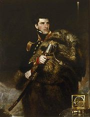
James Weddell
James WeddellJames Weddell
James Weddell was a British sailor, navigator and seal hunter who in the early Spring of 1823 sailed to latitude of 74°15' S and into a region of the Southern Ocean that later became known as the Weddell Sea.-Early life:He entered the merchant service very...
was an Anglo-Scottish seaman who saw service in both the Royal Navy
Royal Navy
The Royal Navy is the naval warfare service branch of the British Armed Forces. Founded in the 16th century, it is the oldest service branch and is known as the Senior Service...
and the merchant marine
Merchant Navy
The Merchant Navy is the maritime register of the United Kingdom, and describes the seagoing commercial interests of UK-registered ships and their crews. Merchant Navy vessels fly the Red Ensign and are regulated by the Maritime and Coastguard Agency...
before undertaking his first voyages to Antarctic waters. In 1819, in command of the 160-ton brigantine
Brigantine
In sailing, a brigantine or hermaphrodite brig is a vessel with two masts, only the forward of which is square rigged.-Origins of the term:...
Jane which had been adapted for whaling, he set sail for the newly discovered whaling grounds of the South Sandwich Islands. His chief interest on this voyage was in finding the "Aurora Islands
Aurora Islands
The Aurora Islands was a group of three phantom islands first reported in 1762 by the Spanish merchant ship Aurora while sailing from Lima to Cádiz. The Aurora's officers reported sighting them again in 1774. The Spanish ship San Miguel fixed their location at 52°37'S, 47°49'W...
", which had been reported at 53°S
53rd parallel south
The 53rd parallel south is a circle of latitude that is 53 degrees south of the Earth's equatorial plane. It crosses the Atlantic Ocean, the Indian Ocean, the Pacific Ocean and South America....
, 48°W
48th meridian west
The meridian 48° west of Greenwich is a line of longitude that extends from the North Pole across the Arctic Ocean, Greenland, the Atlantic Ocean, South America, the Southern Ocean, and Antarctica to the South Pole....
by the Spanish ship Aurora in 1762. He failed to discover this non-existent land, but his sealing activities showed a handsome profit.
40th meridian west
The meridian 40° west of Greenwich is a line of longitude that extends from the North Pole across the Arctic Ocean, Greenland, the Atlantic Ocean, South America, the Southern Ocean, and Antarctica to the South Pole....
, deep into the sea that now bears his name. The season was unusually calm, and Weddell reported that "not a particle of ice of any description was to be seen". On 20 February 1823, he reached a new Farthest South of 74°15'S, three degrees beyond Cook's former record. Unaware that he was close to land, Weddell decided to return northward from this point, convinced that the sea continued as far as the South Pole. Another two days’ sailing would likely have brought him within sight of Coats Land
Coats Land
Coats Land is a region in Antarctica which lies westward of Queen Maud Land and forms the eastern shore of the Weddell Sea, extending in a general northeast-southwest direction between 20º00´W and 36º00´W. The northeast part was discovered from the Scotia by William S. Bruce, leader of the Scottish...
, which was not discovered until 1904, by William Speirs Bruce
William Speirs Bruce
William Speirs Bruce was a London-born Scottish naturalist, polar scientist and oceanographer who organised and led the Scottish National Antarctic Expedition to the South Orkney Islands and the Weddell Sea. Among other achievements, the expedition established the first permanent weather station...
during the Scottish National Antarctic Expedition
Scottish National Antarctic Expedition
The Scottish National Antarctic Expedition , 1902–04, was organised and led by William Speirs Bruce, a natural scientist and former medical student from the University of Edinburgh. Although overshadowed in prestige terms by Robert Falcon Scott's concurrent Discovery Expedition, the SNAE completed...
, 1902–04. On his return to England, Weddell's claim to have exceeded Cook's record by such a margin "caused some raised eyebrows", but was soon accepted.
Benjamin Morrell
In November 1823 the American sealing captain Benjamin MorrellBenjamin Morrell
Benjamin Morrell was an American sealing captain and explorer who between 1823 and 1831 made a series of voyages, mainly to the Southern Ocean and the Pacific Islands, which are recorded in a colourful memoir A Narrative of Four Voyages...
reached the South Sandwich Islands in the schooner Wasp. According to his own later account he then sailed south, unconsciously following the track taken by James Weddell a month previously. Morrell claimed to have reached 70°14'S, at which point he turned north because the ship's stoves were running short of fuel—otherwise, he says, he could have "reached 85° without the least doubt." After turning, he claimed to have encountered land which he described in some detail, and which he named New South Greenland
New South Greenland
New South Greenland, sometimes known as Morrell's Land, was an appearance of land recorded by the American captain Benjamin Morrell of the schooner Wasp in , during a sealing and exploration voyage in the Weddell Sea area of Antarctica. Morrell provided precise coordinates and a description of a...
. This land proved not to exist. Morrell's reputation as a liar and a fraud means that most of his geographical claims have been dismissed by scholars, although attempts have been made to rationalise his assertions.
James Clark Ross
James Clark RossJames Clark Ross
Sir James Clark Ross , was a British naval officer and explorer. He explored the Arctic with his uncle Sir John Ross and Sir William Parry, and later led his own expedition to Antarctica.-Arctic explorer:...
's 1839–43 Antarctic expedition in HMS Erebus
HMS Erebus (1826)
HMS Erebus was a Hecla-class bomb vessel designed by Sir Henry Peake and constructed by the Royal Navy in Pembroke dockyard, Wales in 1826. The vessel was named after the dark region in Hades of Greek mythology called Erebus...
and HMS Terror
HMS Terror (1813)
HMS Terror was a bomb vessel designed by Sir Henry Peake and constructed by the Royal Navy in the Davy shipyard in Topsham, Devon. The ship, variously listed as being of either 326 or 340 tons, carried two mortars, one and one .-War service:...
was a full-scale Royal Naval enterprise, the principal function of which was to test current theories on magnetism, and to try to locate the South Magnetic Pole
South Magnetic Pole
The Earth's South Magnetic Pole is the wandering point on the Earth's surface where the geomagnetic field lines are directed vertically upwards...
. The expedition had first been proposed by leading astronomer Sir John Herschel, and was supported by the Royal Society
Royal Society
The Royal Society of London for Improving Natural Knowledge, known simply as the Royal Society, is a learned society for science, and is possibly the oldest such society in existence. Founded in November 1660, it was granted a Royal Charter by King Charles II as the "Royal Society of London"...
and the British Association for the Advancement of Science
British Association for the Advancement of Science
frame|right|"The BA" logoThe British Association for the Advancement of Science or the British Science Association, formerly known as the BA, is a learned society with the object of promoting science, directing general attention to scientific matters, and facilitating interaction between...
. Ross had considerable past experience in magnetic observation and Arctic exploration; in May 1831 he had been a member of a party that had reached the location of the North Magnetic Pole
North Magnetic Pole
The Earth's North Magnetic Pole is the point on the surface of the Northern Hemisphere at which the Earth's magnetic field points vertically downwards . Though geographically in the north, it is, by the direction of the magnetic field lines, physically the south pole of the Earth's magnetic field...
, and he was an obvious choice as commander.
Tasmania
Tasmania is an Australian island and state. It is south of the continent, separated by Bass Strait. The state includes the island of Tasmania—the 26th largest island in the world—and the surrounding islands. The state has a population of 507,626 , of whom almost half reside in the greater Hobart...
in August 1840. Following a three-month break imposed by the southern winter, they sailed south-east on 12 November 1840, and crossed the Antarctic Circle
Antarctic Circle
The Antarctic Circle is one of the five major circles of latitude that mark maps of the Earth. For 2011, it is the parallel of latitude that runs south of the Equator.-Description:...
on 1 January 1841. On 11 January a long mountainous coastline that stretched to the south was sighted. Ross named the land Victoria Land
Victoria Land
Victoria Land is a region of Antarctica bounded on the east by the Ross Ice Shelf and the Ross Sea and on the west by Oates Land and Wilkes Land. It was discovered by Captain James Clark Ross in January 1841 and named after the UK's Queen Victoria...
, and the mountains the Admiralty Range. He followed the coast southwards and passed Weddell's Farthest South point of 74°15'S on 23 January. A few days later, as they moved further eastward to avoid shore ice, they were met by the sight of twin volcanoes (one of them active), which were named Mount Erebus
Mount Erebus
Mount Erebus in Antarctica is the southernmost historically active volcano on Earth, the second highest volcano in Antarctica , and the 6th highest ultra mountain on an island. With a summit elevation of , it is located on Ross Island, which is also home to three inactive volcanoes, notably Mount...
and Mount Terror
Mount Terror (Antarctica)
Mount Terror is a large shield volcano that forms the eastern part of Ross Island, Antarctica. It has numerous cinder cones and domes on the flanks of the shield and is mostly under snow and ice. It is the second largest of the four volcanoes which make up Ross Island and is somewhat overshadowed...
, in honour of the expedition’s ships.
The Great Ice Barrier
Ross Ice Shelf
The Ross Ice Shelf is the largest ice shelf of Antarctica . It is several hundred metres thick. The nearly vertical ice front to the open sea is more than 600 km long, and between 15 and 50 metres high above the water surface...
(later to be called the "Ross Ice Shelf") stretched away east of these mountains, forming an impassable obstacle to further southward progress. In his search for a strait or inlet, Ross explored 300 nmi (555.6 km; 345.2 mi) along the edge of the barrier, and reached an approximate latitude of 78°S
78th parallel south
The 78th parallel south is a circle of latitude that is 78 degrees south of the Earth's equatorial plane in the Antarctic. The parallel passes through the Southern Ocean and Antarctica....
on or about 8 February 1841. He failed to find a suitable anchorage that would have allowed the ships to over-winter, so he returned to Tasmania, arriving there in April 1841.
The following season Ross returned and located an inlet in the Barrier face that enabled him, on 23 January 1842, to extend his Farthest South to 78°09'30"S, a record which would remain unchallenged for 58 years. Although Ross had not been able to land on the Antarctic continent, nor approach the location of the South Magnetic Pole, on his return to England in 1843 he was knighted for his achievements in geographical and scientific exploration.
Explorers of the Heroic Age
The oceanographic research voyage known as the Challenger ExpeditionChallenger expedition
The Challenger expedition of 1872–76 was a scientific exercise that made many discoveries to lay the foundation of oceanography. The expedition was named after the mother vessel, HMS Challenger....
, 1873–76, explored Antarctic waters, but did not approach the land itself; its researches, however, proved the existence of an Antarctic continent beyond reasonable doubt. The impetus for what would become known as the Heroic Age of Antarctic Exploration came in 1893, when in a lecture to the Royal Geographical Society
Royal Geographical Society
The Royal Geographical Society is a British learned society founded in 1830 for the advancement of geographical sciences...
Professor Sir John Murray
John Murray (oceanographer)
Sir John Murray KCB FRS FRSE FRSGS was a pioneering Scottish oceanographer, marine biologist and limnologist.-Early life:...
called for a resumption of Antarctic exploration: "a steady, continuous, laborious and systematic exploration of the whole southern region". He followed this call with an appeal to British patriotism: "Is the last great piece of maritime exploration on the surface of our Earth to be undertaken by Britons, or is it to be left to those who may be destined to succeed or supplant us on the Ocean?" During the following quarter-century, fifteen expeditions from eight different nations rose to this challenge. In the patriotic spirit engendered by Murray's call, and under the influence of RGS president Sir Clements Markham, British endeavours in the following years gave particular weight to the achievement of new Farthest South records, and began to develop the character of a race for the South Pole.
Carsten Borchgrevink
The Norwegian-born Carsten Egeberg Borchgrevink had emigrated to Australia in 1888, where he worked on survey teams in Queensland and New South Wales before accepting a school-teaching post. In 1894 he joined a sealing and whaling expedition to the Antarctic, led by Henryk BullHenryk Bull
Henryk Bull was a Norwegian businessman and shipping magnate. Henry Bull was one of the pioneers in the exploration of Antarctica.-Biography:...
. In January 1895 Borchgrevink was one of a group from that expedition that claimed the first confirmed landing on the Antarctic continent, at Cape Adare
Cape Adare
Cape Adare is the northeastern most peninsula in Victoria Land, East Antarctica. The cape separates the Ross Sea to the east from the Southern Ocean to the west, and is backed by the high Admiralty Mountains...
. Borchgrevink determined to return with his own expedition, which would overwinter and explore inland, with the location of the South Magnetic Pole as an objective.
Borchgrevink went to England, where he was able to persuade the publishing magnate Sir George Newnes
George Newnes
Sir George Newnes, 1st Baronet was a publisher and editor in England.-Background and education:...
to finance him to the extent of £40,000, equivalent to £3 million as of 2008, with the sole stipulation that, despite the shortage of British participants, the venture be styled the "British Antarctic Expedition". This was by no means the grand British expedition envisaged by Markham and the geographical establishment, who were hostile and dismissive of Borchgrevink. On 23 August 1898 the expedition ship Southern Cross left London for the Ross Sea
Ross Sea
The Ross Sea is a deep bay of the Southern Ocean in Antarctica between Victoria Land and Marie Byrd Land.-Description:The Ross Sea was discovered by James Ross in 1841. In the west of the Ross Sea is Ross Island with the Mt. Erebus volcano, in the east Roosevelt Island. The southern part is covered...
, reaching Cape Adare on 17 February 1899. Here a shore party was landed and was the first to over-winter on the Antarctic mainland, in a prefabricated hut.
In January 1900 Southern Cross returned, picked up the shore party and, following the route which Ross had taken 60 years previously, sailed southward to the Great Ice Barrier, which they discovered had retreated some 30 miles (48.3 km) south since the days of Ross. A party consisting of Borchgrevink, William Colbeck and a Sami
Sami people
The Sami people, also spelled Sámi, or Saami, are the arctic indigenous people inhabiting Sápmi, which today encompasses parts of far northern Sweden, Norway, Finland, the Kola Peninsula of Russia, and the border area between south and middle Sweden and Norway. The Sámi are Europe’s northernmost...
called Per Savio landed with sledges and dogs. This party ascended the Barrier and made the first sledge journey on the barrier surface; on 16 February 1900 they extended the Farthest South record to 78°50'S. On its return to England later in 1900, Borchgrevink’s expedition was received without enthusiasm, despite its new southern record. Historian David Crane commented that if Borchgrevink had been a British naval officer, his contribution to Antarctic knowledge might have been better received, but "a Norwegian seaman/schoolmaster was never going to be taken seriously".
Robert Falcon Scott
The Discovery ExpeditionDiscovery Expedition
The British National Antarctic Expedition, 1901–04, generally known as the Discovery Expedition, was the first official British exploration of the Antarctic regions since James Clark Ross's voyage sixty years earlier...
of 1901–04 was Captain Scott's first Antarctic command. Although according to Edward Wilson
Edward Adrian Wilson
Edward Adrian Wilson was a notable English polar explorer, physician, naturalist, painter and ornithologist.-Early life:...
the intention was to "reach the Pole if possible, or find some new land", there is nothing in Scott's writings, nor in the official objectives of the expedition, to indicate that the pole was a definite goal. However, a southern journey towards the pole was within Scott’s formal remit to "explore the ice barrier of Sir James Ross ... and to endeavour to solve the very important physical and geographical questions connected with this remarkable ice formation".
The southern journey was undertaken by Scott, Wilson and Ernest Shackleton
Ernest Shackleton
Sir Ernest Henry Shackleton, CVO, OBE was a notable explorer from County Kildare, Ireland, who was one of the principal figures of the period known as the Heroic Age of Antarctic Exploration...
. The party set out on 1 November 1902 with various teams in support, and one of these, led by Michael Barne
Michael Barne
Michael Barne was an officer of the 1901-04 Discovery Expedition and was the last survivor of the expedition.-Early life:...
, passed Borchgrevink's Farthest South mark on 11 November, an event recorded with great high spirits in Wilson's diary. The march continued, initially in favourable weather conditions, but encountered increasing difficulties caused by the party's lack of ice travelling experience and the loss of all its dogs through a combination of poor diet and overwork. The 80°S
80th parallel south
The 80th parallel south is a circle of latitude that is 80 degrees south of the Earth's equatorial plane.It passes through Antarctica and Antarctic ice shelves.Starting at the Prime Meridian and heading eastwards, the parallel 80° south passes through:...
mark was passed on 2 December, and four weeks later, on 30 December 1902, Wilson and Scott took a short ski trip from their southern camp to set a new Farthest South at (according to their measurements) 82°17'S. This may not be exact; modern maps, correlated with Shackleton's photograph and Wilson's drawing, put their final camp at 82°6'S, and the point reached by Scott and Wilson at 82°11'S. Whatever the precise latitude, they had surpassed Borchgrevink's mark by approximately 200 nmi (370.4 km; 230.2 mi)
Ernest Shackleton
After his share in the Farthest South achievement of the Discovery Expedition, Ernest ShackletonErnest Shackleton
Sir Ernest Henry Shackleton, CVO, OBE was a notable explorer from County Kildare, Ireland, who was one of the principal figures of the period known as the Heroic Age of Antarctic Exploration...
suffered a physical collapse on the return journey, and was sent home with the expedition’s relief vessel on orders from Scott; the two became rivals. Four years later, Shackleton organised his own polar venture, the Nimrod Expedition
Nimrod Expedition
The British Antarctic Expedition 1907–09, otherwise known as the Nimrod Expedition, was the first of three expeditions to the Antarctic led by Ernest Shackleton. Its main target, among a range of geographical and scientific objectives, was to be first to the South Pole...
, 1907–09. This was the first expedition to set the definite objective of reaching the South Pole, and to have a specific strategy for doing so.
To assist his endeavour, Shackleton adopted a mixed transport strategy, involving the use of Manchurian ponies as pack animals, as well as the more traditional dog-sledges. A specially adapted motor car was also taken. Although the dogs and the car were used during the expedition for a number of purposes, the task of assisting the group that would undertake the march to the pole fell to the ponies. The size of Shackleton’s four-man polar party was dictated by the number of surviving ponies; of the ten that were embarked in New Zealand, only four had survived the 1908 winter.
Ernest Shackleton
Ernest Shackleton
Sir Ernest Henry Shackleton, CVO, OBE was a notable explorer from County Kildare, Ireland, who was one of the principal figures of the period known as the Heroic Age of Antarctic Exploration...
and three companions (Frank Wild
Frank Wild
Commander John Robert Francis Wild CBE, RNVR, FRGS , known as Frank Wild, was an explorer...
, Eric Marshall
Eric Marshall
Eric Marshall was an Antarctica explorer with the Nimrod Expedition led by Ernest Shackleton in 1907-09, and was one of the party of four who reached Furthest South at on 9 January 1909...
and Jameson Adams
Jameson Adams
Sir Jameson Adams was an Antarctic explorer with the Nimrod Expedition, the first expedition led by Ernest Shackleton in an unsuccessful attempt to reach the South Pole. Nevertheless, he was one of the party of four who reached the Polar Plateau for the first time ever, thus showing the way to the...
) began their march on 29 October 1908. On 26 November they surpassed the farthest point reached by Scott's 1902 party. "A day to remember", wrote Shackleton in his journal, noting that they had reached this point in far less time than on the previous march with Captain Scott. Shackleton’s group continued southward, discovering and ascending the Beardmore Glacier
Beardmore Glacier
The Beardmore Glacier in Antarctica is one of the largest glaciers in the world, with a length exceeding 160 km . The glacier is one of the main passages from the Ross Ice Shelf through the Queen Alexandra and Commonwealth ranges of the Transantarctic Mountains to the Antarctic Plateau, and was one...
to the polar plateau, and then marching on to reach their Farthest South point at 88°23'S, a mere 97 nmi (179.6 km; 111.6 mi) from the pole, on 9 January 1909. Here they planted the Union Jack presented to them by Queen Alexandra, and took possession of the plateau in the name of King Edward VII, before shortages of food and supplies forced them to turn back north. This was, at the time, the closest convergence on either pole. The increase of more than six degrees south from Scott's previous record was the greatest extension of Farthest South since Captain Cook's 1773 mark. Shackleton was treated as a hero on his return to England, and was knighted by King Edward. However, the record was to stand for less than three years, being passed by Amundsen on 7 December 1911.
Polar conquest
In the wake of Shackleton’s near miss, Captain Scott organised the Terra Nova ExpeditionTerra Nova Expedition
The Terra Nova Expedition , officially the British Antarctic Expedition 1910, was led by Robert Falcon Scott with the objective of being the first to reach the geographical South Pole. Scott and four companions attained the pole on 17 January 1912, to find that a Norwegian team led by Roald...
, 1910–13, in which securing the South Pole for the British Empire was an explicitly stated prime objective. As he planned his expedition, Scott saw no reason to believe that his effort would be contested. However, the Norwegian explorer Roald Amundsen
Roald Amundsen
Roald Engelbregt Gravning Amundsen was a Norwegian explorer of polar regions. He led the first Antarctic expedition to reach the South Pole between 1910 and 1912 and he was the first person to reach both the North and South Poles. He is also known as the first to traverse the Northwest Passage....
, who had been developing plans for a North Pole expedition, changed his mind when, in September 1909, the North Pole was claimed in quick succession by the Americans Frederick Cook
Frederick Cook
Frederick Albert Cook was an American explorer and physician, noted for his claim of having reached the North Pole on April 21, 1908. This would have been a year before April 6, 1909, the date claimed by Robert Peary....
and Robert Peary
Robert Peary
Robert Edwin Peary, Sr. was an American explorer who claimed to have been the first person, on April 6, 1909, to reach the geographic North Pole...
. Amundsen resolved to go south instead.
Amundsen concealed his revised intentions until his ship, Fram, was in the Atlantic and beyond communication. Scott was notified by telegram that a rival was in the field, but had little choice other than to continue with his own plans. Meanwhile, Fram arrived at the Ross Ice Shelf on 11 January 1911, and by 14 January had found the inlet, or "Bay of Whales
Bay of Whales
The Bay of Whales is a natural ice harbor, or iceport, indenting the front of Ross Ice Shelf just north of Roosevelt Island. It is the southernmost point of open ocean not only of the Ross Sea, but worldwide...
", where Borchgrevink had made his landing eleven years earlier. This was to be the location of Amundsen's base camp, Framheim
Framheim
Framheim was the name of explorer Roald Amundsen's base at the Bay of Whales on the Ross Ice Shelf in Antarctica during his quest for the South Pole...
.
After nine months’ preparation, Amundsen's polar journey began on 20 October 1911. Avoiding the known route to the polar plateau via the Beardmore Glacier, Amundsen led his party of five due south, reaching the Transantarctic Mountains
Transantarctic Mountains
The three largest mountain ranges on the Antarctic continent are the Transantarctic Mountains , the West Antarctica Ranges, and the East Antarctica Ranges. The Transantarctic Mountains compose a mountain range in Antarctica which extend, with some interruptions, across the continent from Cape Adare...
on 16 November. They discovered the Axel Heiberg Glacier
Axel Heiberg Glacier
The Axel Heiberg Glacier is a valley glacier, long, descending from the high-elevations of the Antarctic Plateau into the Ross Ice Shelf between the Herbert Range and Mount Don Pedro Christophersen in the Queen Maud Mountains....
, which provided a route for their ascent to the plateau, and then made the final march to the pole. Shackleton's Farthest South mark was passed on 7 December, and the South Pole itself, at 90°S, was reached on 14 December 1911. The Norwegian party's greater skills with the techniques of ice travel, using ski and dogs, had proved decisive. Captain Scott's five-man team reached the same point 33 days later, and perished during their return journey. Since Cook's journeys, every expedition that had held the Farthest South record before Amundsen's conquest had been British; however, the final triumph indisputably belonged to the Norwegians.
Later history
Commander
Commander is a naval rank which is also sometimes used as a military title depending on the individual customs of a given military service. Commander is also used as a rank or title in some organizations outside of the armed forces, particularly in police and law enforcement.-Commander as a naval...
(later Rear-Admiral) Richard E. Byrd and three others completed the first aircraft flight over the South Pole. Twenty-seven years later, Rear-Admiral George J. Dufek
George J. Dufek
George John Dufek was an American naval officer, naval aviator, and Arctic expert. He served in World War II and the Korean War and in the 1940s and 1950s spent much of his career in the Antarctic, first with Admiral Byrd and later as supervisor of U.S. programs in the South Polar regions...
became the first person to set foot on the pole since Scott, when on 31 October 1956 he and the crew of R4D-5 Skytrain "Que Sera Sera" landed at the pole. Between November 1956 and February 1957, the first permanent South Pole research station was erected and christened the Amundsen–Scott South Pole Station in honour of the pioneer explorers. Since then the station had been substantially extended, housing up to 150 scientific staff and support personnel as of 2008. Dufek gave considerable assistance to the Commonwealth Trans-Antarctic Expedition
Commonwealth Trans-Antarctic Expedition
The 1955–58 Commonwealth Trans-Antarctic Expedition was a Commonwealth-sponsored expedition that successfully completed the first overland crossing of Antarctica, via the South Pole...
, 1955–58, led by Vivian Fuchs
Vivian Fuchs
Sir Vivian Ernest Fuchs FRS was an English explorer whose expeditionary team completed the first overland crossing of Antarctica in 1958.- Biography :...
, which on 19 January 1958 became the first party to reach the pole overland since Scott.
Farthest South records
-
-
-
-
- Table of Farthest South records, 1521 to 1911 (letters in "Map key" column relate to adjoining map)
-
-
-
| Expedition leader | Country | Latitude achieved | Location | Map key | Date |
|---|---|---|---|---|---|
| Aboriginal inhabitants of Tierra del Fuego | ----- | 55°58' | Cape Horn | B | Present in 1521 |
 Ferdinand Magellan Ferdinand Magellan |
54° 54th parallel south The 54th parallel south is a circle of latitude that is 54 degrees south of the Earth's equatorial plane. It crosses the Atlantic Ocean, the Indian Ocean, the Pacific Ocean and South America.... (approximate) |
Strait of Magellan; inhabited land southward on Tierra del Fuego | A | November 1521 | |
 Francisco de Hoces Francisco de Hoces |
55°59' (speculative) | Cape Horn | B | January 1526 | |
 Sir Francis Drake Sir Francis Drake |
55°59' (speculative) | Cape Horn | B | October 1578 | |
| Bartolemo and Gonzalo Garcia de Nodal |
56°30' | Drake Passage: Diego Ramirez Islands | C | February 1619 | |
 James Cook James Cook |
Kingdom of Great Britain |
66°20' | SE of Cape Town | D | 17 January 1773 |
| James Cook |
Kingdom of Great Britain |
71°10' | SE of New Zealand | E | 30 January 1774 |
| James Weddell | 74°15' | Weddell Sea | F | 20 February 1823 | |
| James Clark Ross | 78° 78th parallel south The 78th parallel south is a circle of latitude that is 78 degrees south of the Earth's equatorial plane in the Antarctic. The parallel passes through the Southern Ocean and Antarctica.... (approximate) |
Ross Sea | G | 8 February 1841 | |
| James Clark Ross | 78°09'30" | Ross Sea | G | 23 January 1842 | |
 / Carsten Borchgrevink / Carsten Borchgrevink |
78°50' | Ross Ice Shelf | H | 16 February 1900 | |
| Robert Falcon Scott | 82°17' (adj. to 82°11') | Ross Ice Shelf | I | 30 December 1902 | |
| Ernest Shackleton | 88°23' | South Polar Plateau | J | 9 January 1909 | |
| Roald Amundsen |
90° | South Pole South Pole The South Pole, also known as the Geographic South Pole or Terrestrial South Pole, is one of the two points where the Earth's axis of rotation intersects its surface. It is the southernmost point on the surface of the Earth and lies on the opposite side of the Earth from the North Pole... |
K | 14 December 1911 |
See also
- History of AntarcticaHistory of AntarcticaThe history of Antarctica emerges from early Western theories of a vast continent, known as Terra Australis, believed to exist in the far south of the globe...
- List of Antarctic expeditions
- Heroic Age of Antarctic ExplorationHeroic Age of Antarctic ExplorationThe Heroic Age of Antarctic Exploration defines an era which extended from the end of the 19th century to the early 1920s. During this 25-year period the Antarctic continent became the focus of an international effort which resulted in intensive scientific and geographical exploration, sixteen...
- Farthest NorthFarthest NorthFarthest North describes the most northerly latitude reached by explorers before the conquest of the North Pole rendered the expression obsolete...
- Vostok StationVostok StationVostok Station was a Russian Antarctic research station. It was at the southern Pole of Cold, with the lowest reliably measured natural temperature on Earth of −89.2 °C . Research includes ice core drilling and magnetometry...
, the South Pole of ColdPole of ColdThe Poles of Cold are the places in the Northern and Southern hemispheres where the lowest air temperatures have been recorded.- Northern hemisphere :... - Pole of Inaccessibility StationPole of inaccessibility (Antarctic research station)Pole of inaccessibility is a now defunct Soviet research station in Antarctica, located near the southern pole of inaccessibility — the point in Antarctica furthest from any ocean. . It performed meteorological observations from 14 December 1958 to 26 December 1958...
, at the South or Antarctic Pole of InaccessibilityPole of inaccessibilityA pole of inaccessibility marks a location that is the most challenging to reach owing to its remoteness from geographical features that could provide access...