Encyclopedia
Cape Horn is the southernmost
headland of the
Tierra del Fuego archipelago of southern
Chile. It is widely considered to be the southern tip of
South America. Cape Horn is the most southerly of the
great capes, and marks the northern boundary of the
Drake Passage; for many years it was a major milestone on the
clipper route, by which
sailing ship
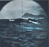
s carried trade around the world. However, the waters around the cape are particularly hazardous, due to strong winds, large waves, and
icebergs; these dangers have made it notorious as a sailors' graveyard.
Today, the
Panama Canal has greatly reduced the need for cargo ships to travel via the Horn. However, sailing around the Horn is widely regarded as one of the major challenges in yachting, and a number of recreational sailors continue to sail this route, sometimes as part of a
circumnavigation of the globe. Several prominent ocean
yacht races, notably the
Vendée Globe, sail around the world via the Horn, and speed records for round-the-world sailing follow the same route.
Geography
Cape Horn is the southernmost point of land closely associated with South America; it is located at , in the
Hermite Islands, at the southern end of the
Tierra del Fuego archipelago. It marks the north edge of the
Drake Passage, the
strait between South America and
Antarctica. The dividing line between the
Atlantic and
Pacific oceans runs along the meridian of Cape Horn, from Tierra del Fuego to the
Southern Ocean.
Cape Horn was originally given the
Dutch name "Kaap Hoorn", in honour of the Dutch city of
Hoorn; in a typical example of false friends, the Horn became known in English as "Cape Horn", and in Spanish as "Cabo de Hornos" . It is commonly known to sailors simply as
The Horn.
The cape is widely considered to be the southernmost point of
South America; it is not a true cape of the American mainland, however, as it is actually situated on a small island,
Hoorn Island , which is the most southerly of the Hermite Islands. A cape on nearby Hoste Island, 56 kilometres to the northwest, is called
False Cape Horn, as sailors approaching from the west would see it in a similar configuration to the real Cape Horn; since the Wollaston Islands are due east of the false cape, this mistake caused several shipwrecks.
The cape lies within
Chilean territorial waters, and the Chilean Navy maintains a station on Hoorn Island, consisting of a residence, utility building, chapel, and lighthouse; the navy supports a lighthouse keeper and his family . A short distance from the main station is a memorial, including a large sculpture featuring the silhouette of an
albatross, in honour of the sailors who died while attempting to "round the Horn". The terrain is entirely treeless, although quite lush due to the frequent precipitation.
Climate
The climate in the region is generally cool, due to the southern latitude. There are no weather stations in the group of islands including Cape Horn; however, a study in 1882-1883 found an annual rainfall of 1,357 millimetres , with an average annual temperature of 5.2 °C . Winds were reported to average 30 kilometres per hour , with squalls of over 100 kilometres per hour occurring in all seasons.
Contemporary weather records for Ushuaia, 146 kilometres north, show that summer average temperatures range from highs of 14 °C to lows of 5 °C ; in winter , average temperatures range from 4 °C to −2 °C . Cloud cover is generally high, with averages from 5.2 eighths in May and July to 6.4 eighths in December and January. Precipitation is high throughout the year: the weather station on the nearby
Diego Ramirez Islands, 109 kilometres south-west in the Drake Passage, shows the greatest rainfall in March, averaging 137.4 millimetres ; while October, which has the least rainfall, still averages 93.7 millimetres . Wind conditions are generally severe, particularly in winter. In summer, the wind at Cape Horn is gale force up to 5% of the time, with generally good visibility; however, in winter, gale force winds occur up to 30% of the time, often with poor visibility.
Political
Cape Horn is part of the commune of Cabo de Hornos , whose capital is
Puerto Williams; this in turn is part of
Antártica Chilena Province, whose capital is also Puerto Williams. The area is part of the Magallanes y la Antártica Chilena Region of
Chile.
The
Argentine city of Ushuaia is the major municipality in the region, with a population of 50,000; Puerto Toro, a few miles south of Puerto Williams, is the closest town to the cape, and the southernmost town in the world.
Depletion of the ozone layer is a significant problem for residents of the region, as the tip of South America is far enough south to be affected by the
Antarctic ozone hole.
Sailing routes
There are a number of potential sailing routes around the tip of South America. The
Strait of Magellan, between the mainland and
Tierra del Fuego, is a major — although narrow — passage, which was in use for trade well before the Horn was discovered; the
Beagle Channel, between Tierra del Fuego and Isla Navarino, offers a potential, though difficult route; and there are various passages around the Wollaston and Hermite Islands to the north of Cape Horn.
All of these, however, are notorious for treacherous williwaw winds, which can strike a vessel with little or no warning; given the narrowness of these routes, there is a significant risk of then being driven onto the rocks. The open waters of the
Drake Passage, south of Cape Horn, provide by far the widest route, at about 650 kilometres wide; this passage offers ample sea room for maneuvering as winds change, and is the route used by most ships and sailboats, despite the possibility of extreme wave conditions. These winds are further exacerbated at the Horn by the funneling effect of the
Andes and the
Antarctic peninsula, which channel the winds into the relatively narrow
Drake Passage.
The strong winds of the Southern Ocean give rise to correspondingly large waves; these waves can attain enormous size as they roll around the
Southern Ocean, free of any interruption from land. At the Horn, however, these waves encounter an area of shallow water to the south of the Horn, which has the effect of making the waves shorter and steeper, greatly increasing the hazard to ships. If the strong eastward current through the Drake Passage encounters an opposing east wind, this can have the effect of further building up the waves. In addition to these "normal" waves, the area west of the Horn is particularly notorious for
rogue waves, which can attain heights of up to 30
metres .
The prevailing winds and currents create particular problems for vessels attempting to round the Horn against them, i.e. from east to west. Although this affects all vessels to some extent, it was a particularly serious problem for traditional sailing ships, which could make very little headway against the wind at the best of times; modern sailing boats are significantly more efficient to windward and can more reliably make a westward passage of the Horn, as they do in the
Global Challenge race.
Finally, ice is a hazard to sailors venturing far below 40° south. Although the ice limit dips south around the horn,
icebergs are a significant hazard for vessels in the area. In the South Pacific in February, icebergs are generally confined to below 50° south; but in August the iceberg hazard can extend north of 40° south. Even in February, though, the Horn is well below the latitude of the iceberg limit. These hazards have made the Horn notorious as perhaps the most dangerous ship passage in the world; many ships were wrecked, and many sailors died, attempting to round the Horn.
History
Discovery
In September 1578, Sir
Francis Drake, in the course of his
circumnavigation of the world, passed through the Strait of Magellan into the
Pacific Ocean. Before he could continue his voyage north his ships encountered a storm, and were blown well to the south of
Tierra del Fuego. The expanse of open water they encountered led Drake to guess that far from being another continent, as previously believed, Tierra del Fuego was an island with open sea to its south. This discovery went unused for some time, as ships continued to use the known passage through the Strait of Magellan.
By the early 1600s, the
Dutch East India Company held a monopoly on all
Dutch trade via the Strait of Magellan and the
Cape of Good Hope, the only two known routes at the time to the
Far East. In an effort to find an alternative route and hence break the monopoly, the Dutch merchant Jacob le Maire, together with navigator Willem Schouten, set off to investigate Drake's suggestion of a route to the south of Tierra del Fuego. Backed by the city leaders of the Dutch town of
Hoorn, the expedition set off in two ships,
Eendracht and
Hoorn, in May, 1615.
Hoorn was accidentally destroyed in
Patagonia, but in January, 1616,
Eendracht passed through the
Le Maire Strait, as it is now known, and sighted a high island to the south. They named the new cape "Kaap Hoorn", in honour of the expedition's sponsors. The Horn exacted a heavy toll from shipping, however, due to the extremely hazardous combination of conditions there.
Traditionally, a sailor who had rounded the Horn was entitled to wear a gold loop earring — in the left ear, the one which had faced the Horn in a typical eastbound passage — and to dine with one foot on the table; a sailor who had also rounded the
Cape of Good Hope could place both feet on the table.
The
transcontinental railroads in North America, as well as the
Panama Canal in Central America, led to the gradual decrease in use of the Horn for trade. As
steamships replaced
sailing ships,
Pamir became the last commercial sailing ship to round Cape Horn laden with cargo, en route from Australia to Finland in 1949.
Recreational and sport sailing
Despite the opening of the
Suez and
Panama Canals, the Horn remains part of the fastest sailing route around the world, and so the growth in recreational long-distance sailing has brought about a revival of sailing via the Horn. Due to the remoteness of the location and the hazards there, a rounding of Cape Horn is widely considered to be the yachting equivalent of climbing
Mount Everest, and so many sailors seek it out for its own sake.
The first small boat to sail around Cape Horn was the 42-foot
yacht Saoirse, sailed by Connor O'Brien with three friends, who rounded it during a
circumnavigation of the world between 1923 and 1925. The first person to successfully
circumnavigate the world single-handed via Cape Horn was Vito Dumas, who made the voyage in 1942 in his 33-foot
ketch Lehg II; a number of other sailors have since followed him.
Today, there are several major
yacht races held regularly along the old clipper route via Cape Horn. The first of these was the
Sunday Times Golden Globe Race, which was a single-handed race; this inspired the present-day
Around Alone race, which circumnavigates with stops, and the
Vendée Globe, which is non-stop. Both of these are single-handed races, and are held every four years. The
Volvo Ocean Race is a crewed race with stops which sails the clipper route every four years. The Jules Verne Trophy is a prize for the fastest circumnavigation of the world by any type of yacht, with no restrictions on the size of the crew . Finally, the
Global Challenge race goes around the world the "wrong way", from east to west, which involves rounding Cape Horn against the prevailing winds and currents.
The Horn remains a major hazard for recreational sailors, however. A classic case is that of Miles and Beryl Smeeton, who attempted to round the Horn in their yacht
Tzu Hang. Hit by a rogue wave when approaching the Horn, the boat pitchpoled . Although they survived, and were able to make repairs in Chile, they attempted the passage again, only to be rolled over, and dismasted for a second time, by another rogue wave.
Literature and culture
Cape Horn has been an icon of sailing culture for centuries; it has featured in sea shanties and in many books about sailing. One of the classic accounts of a working ship in the age of sail is
Two Years Before the Mast: A Personal Narrative, by Richard Henry Dana, in which the author describes an arduous trip from Boston to California via Cape Horn:
Just before eight o'clock the cry of "All hands ahoy!" was sounded down the fore scuttle and the after hatchway, and hurrying upon deck, we found a large black cloud rolling on toward us from the south-west, and blackening the whole heavens. "Here comes Cape Horn!" said the chief mate; and we had hardly time to haul down and clew up, before it was upon us. In a few moments, a heavier sea was raised than I had ever seen before, and as it was directly ahead, the little brig, which was no better than a bathing machine, plunged into it, and all the forward part of her was under water; the sea pouring in through the bow-ports and hawse-hole and over the knightheads, threatening to wash everything overboard. In the lee scuppers it was up to a man's waist. We sprang aloft and double reefed the topsails, and furled all the other sails, and made all snug. But this would not do; the brig was laboring and straining against the head sea, and the gale was growing worse and worse. At the same time sleet and hail were driving with all fury against us. We clewed down, and hauled out the reef-tackles again, and close-reefed the fore-topsail, and furled the main, and hove her to on the starboard tack. Here was an end to our fine prospects.
Charles Darwin, in
The Voyage of the Beagle, a journal of the five-year expedition upon which he based
The Origin of Species by English [i] naturalist [i] ...
, described his 1832 encounter with the Horn:
... we closed in with the Barnevelts, and running past Cape Deceit with its stony peaks, about three o'clock doubled the weather-beaten Cape Horn. The evening was calm and bright, and we enjoyed a fine view of the surrounding isles. Cape Horn, however, demanded his tribute, and before night sent us a gale of wind directly in our teeth. We stood out to sea, and on the second day again made the land, when we saw on our weather-bow this notorious promontory in its proper form — veiled in a mist, and its dim outline surrounded by a storm of wind and water. Great black clouds were rolling across the heavens, and squalls of rain, with hail, swept by us with such extreme violence, that the Captain determined to run into Wigwam Cove. This is a snug little harbour, not far from Cape Horn; and here, at Christmas-eve, we anchored in smooth water.
Alan Villiers, a modern-day expert in traditional
sailing ships, wrote many books about traditional sailing, including
By way of Cape Horn. More recent sailors have taken on the Horn singly, such as Vito Dumas, who wrote
Alone Through The Roaring Forties based on his round-the-world voyage; or with small crews.
In the latter category, Hal and Margaret Roth did much to popularise ocean sailing with several books, including
Two against Cape Horn, describing their voyage around the Horn; and the father-son team of David and Daniel Hays describe their voyage as a bonding experience in
My Old Man and the Sea.
Bernard Moitessier made two significant voyages round the horn; once with his wife Françoise, described in
Cape Horn: The Logical Route, and once
single-handed. His book
The Long Way tells the story of this latter voyage, and of a peaceful night-time passage of the Horn:
The little cloud underneath the moon has moved to the right. I look... there it is, so close, less than 10 miles away and right under the moon. And nothing remains but the sky and the moon playing with the Horn.
I look. I can hardly believe it. So small and so huge. A hillock, pale and tender in the moonlight; a colossal rock, hard as diamond.
Further reading
- Around Cape Horn: A Maritime Artist/Historian's Account of His 1892 Voyage, by Charles G. Davis and Neal Parker. Down East Books, 2004. ISBN 0-89272-646-6
- Cape Horn: The Story of the Cape Horn Region, by Felix Riesenberg and William A. Briesemeister. Ox Bow Press, 1994. ISBN 1-881987-04-3
- Cape Horn and Other Stories From the End of the World, by Francisco Coloane. Latin American Literary Review Press, 2003. ISBN 1-891270-17-6
- Gipsy Moth Circles the World, Sir Francis Chichester; International Marine, 2001. ISBN 0-07-136449-8
- Rounding the Horn: Being the Story of Williwaws and Windjammers, Drake, Darwin, Murdered Missionaries and Naked Natives - A Deck's-Eye View of Cape Horn, by Dallas Murphy. Basic Books, 2004. ISBN 0-465-04759-9
- En el Mar Austral, by Fray Mocho. University of Buenos Aires Press , 1960. An incredible account of the southern tip of South American by an Argentine Journalist.
- High Endeavours, by Miles Clark. Greystone, 2002. ISBN 1-55054-058-0 An account of the lives of the author's god-father Miles Smeeton, and his wife Beryl, including a couple of spectacular trips to the Horn.
See also
References
External links
- — antique charts of the Cape Horn region, from Victory Cruises
- — Ellen MacArthur's rendezvous at Cabo de Hornos
- — description of an 1853 passage of the Horn
- — relevant discussion of Cape Horn and Drake Passage
-