
Victoria Land
Encyclopedia
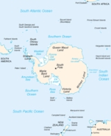
Victoria Land is a region of Antarctica bounded on the east by the Ross Ice Shelf
and the Ross Sea
and on the west by Oates Land
and Wilkes Land
. It was discovered by Captain James Clark Ross
in January 1841 and named after the UK's Queen Victoria
. The rocky promontory of Minna Bluff
is often regarded as the southernmost point of Victoria Land, and separates the Scott Coast
to the north from the Hillary Coast
of the Ross Dependency
to the south.
The region includes ranges of the Transantarctic Mountains
and the McMurdo Dry Valleys
(the highest point being Mount Abbott in the Northern Foothills
), and the flatlands known as the Labyrinth
. Early explorers of Victoria Land include James Clark Ross and Douglas Mawson
.
Ross Ice Shelf
The Ross Ice Shelf is the largest ice shelf of Antarctica . It is several hundred metres thick. The nearly vertical ice front to the open sea is more than 600 km long, and between 15 and 50 metres high above the water surface...
and the Ross Sea
Ross Sea
The Ross Sea is a deep bay of the Southern Ocean in Antarctica between Victoria Land and Marie Byrd Land.-Description:The Ross Sea was discovered by James Ross in 1841. In the west of the Ross Sea is Ross Island with the Mt. Erebus volcano, in the east Roosevelt Island. The southern part is covered...
and on the west by Oates Land
Oates Land
Oates Land is a wedge-shaped segment of East Antarctica stretching along and inland from the Oates Coast. Part of the Australian claim to the Antarctic, it extends between 153°45' E and 150° E, forming a wedge between 60° S and the South Pole. It is bounded in the east by the Ross Dependency and in...
and Wilkes Land
Wilkes Land
Wilkes Land is a large district of land in eastern Antarctica, formally claimed by Australia as part of the Australian Antarctic Territory, though the validity of this claim has been placed for the period of the operation of the Antarctic Treaty, to which Australia is a signatory...
. It was discovered by Captain James Clark Ross
James Clark Ross
Sir James Clark Ross , was a British naval officer and explorer. He explored the Arctic with his uncle Sir John Ross and Sir William Parry, and later led his own expedition to Antarctica.-Arctic explorer:...
in January 1841 and named after the UK's Queen Victoria
Victoria of the United Kingdom
Victoria was the monarch of the United Kingdom of Great Britain and Ireland from 20 June 1837 until her death. From 1 May 1876, she used the additional title of Empress of India....
. The rocky promontory of Minna Bluff
Minna Bluff
Minna Bluff is a rocky promontory at the eastern end of a volcanic Antarctic peninsula projecting deep into the Ross Ice Shelf at . It forms a long, narrow arm which culminates in a south-pointing hook feature , and is the subject of research into Antarctic cryosphere history, funded by the...
is often regarded as the southernmost point of Victoria Land, and separates the Scott Coast
Scott Coast
Scott Coast is that portion of the coast of Victoria Land between Cape Washington and Minna Bluff. Named by New Zealand Antarctic Place-Names Committee in 1961 after Captain Robert Falcon Scott, Royal Navy, leader of the Discovery expedition and the British Antarctic Expedition , who lost his...
to the north from the Hillary Coast
Hillary Coast
Hillary Coast is that portion of the coast along the west margin of the Ross Ice Shelf between Minna Bluff and Cape Selborne. Named by New Zealand Antarctic Place-Names Committee in 1961 for Sir Edmund Hillary, leader of the New Zealand Party of the Commonwealth Trans-Antarctic Expedition, 1956-58...
of the Ross Dependency
Ross Dependency
The Ross Dependency is a region of Antarctica defined by a sector originating at the South Pole, passing along longitudes 160° east to 150° west, and terminating at latitude 60° south...
to the south.
The region includes ranges of the Transantarctic Mountains
Transantarctic Mountains
The three largest mountain ranges on the Antarctic continent are the Transantarctic Mountains , the West Antarctica Ranges, and the East Antarctica Ranges. The Transantarctic Mountains compose a mountain range in Antarctica which extend, with some interruptions, across the continent from Cape Adare...
and the McMurdo Dry Valleys
McMurdo Dry Valleys
The McMurdo Dry Valleys are a row of snow-free valleys in Antarctica located within Victoria Land west of McMurdo Sound. The region is one of the world's most extreme deserts, and includes many interesting features including Lake Vida and the Onyx River, Antarctica's longest river.-Climate:The Dry...
(the highest point being Mount Abbott in the Northern Foothills
Northern Foothills
Northern Foothills is a line of coastal hills on the west side of Terra Nova Bay, Victoria Land, lying southward of Browning Pass and forming a peninsular continuation of the Deep Freeze Range...
), and the flatlands known as the Labyrinth
Labyrinth (Antarctica)
The Labyrinth is an extensive flat upland area which has been deeply eroded at the west end of Wright Valley, in Victoria Land. It was so named by the Victoria University of Wellington Antarctic Expedition because the eroded dolerite of which it is formed gives an appearance of a labyrinth....
. Early explorers of Victoria Land include James Clark Ross and Douglas Mawson
Douglas Mawson
Sir Douglas Mawson, OBE, FRS, FAA was an Australian geologist, Antarctic explorer and Academic. Along with Roald Amundsen, Robert Falcon Scott, and Ernest Shackleton, Mawson was a key expedition leader during the Heroic Age of Antarctic Exploration.-Early work:He was appointed geologist to an...
.