

New South Greenland
Encyclopedia
Phantom island
Phantom islands are islands that were believed to exist, and appeared on maps for a period of time during recorded history, but were later removed after they were proved to be nonexistent...
recorded by the American captain Benjamin Morrell
Benjamin Morrell
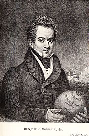
Benjamin Morrell was an American sealing captain and explorer who between 1823 and 1831 made a series of voyages, mainly to the Southern Ocean and the Pacific Islands, which are recorded in a colourful memoir A Narrative of Four Voyages...
of the schooner
Schooner
A schooner is a type of sailing vessel characterized by the use of fore-and-aft sails on two or more masts with the forward mast being no taller than the rear masts....
Wasp in , during a sealing
Seal hunting
Seal hunting, or sealing, is the personal or commercial hunting of seals. The hunt is currently practiced in five countries: Canada, where most of the world's seal hunting takes place, Namibia, the Danish region of Greenland, Norway and Russia...
and exploration voyage in the Weddell Sea
Weddell Sea
The Weddell Sea is part of the Southern Ocean and contains the Weddell Gyre. Its land boundaries are defined by the bay formed from the coasts of Coats Land and the Antarctic Peninsula. The easternmost point is Cape Norvegia at Princess Martha Coast, Queen Maud Land. To the east of Cape Norvegia is...
area of Antarctica. Morrell provided precise coordinates and a description of a coastline which he claimed to have sailed along for more than 300 miles (482.8 km). Because the Weddell Sea area was so little visited, and hard to navigate due to ice conditions, the alleged land was never properly investigated before its existence was emphatically disproved during Antarctic expeditions in the early 20th century.
At the time of Morrell's voyage, the geography of the then unnamed Weddell Sea and its surrounding coasts was almost entirely unknown, making the claimed sighting initially plausible. However, obvious errors in Morrell's voyage account, and his general reputation as a fabulist
Fable
A fable is a succinct fictional story, in prose or verse, that features animals, mythical creatures, plants, inanimate objects or forces of nature which are anthropomorphized , and that illustrates a moral lesson , which may at the end be expressed explicitly in a pithy maxim.A fable differs from...
, created scepticism about the existence of this new land. In the German explorer Wilhelm Filchner
Wilhelm Filchner
Wilhelm Filchner was a German explorer.At the age of 21, he participated in his first expedition, which led him to Russia. Two years later, he travelled alone and on horseback through the Pamir Mountains, from Osh to Murgabh to the upper Wakhan to Tashkurgan and back...
searched for but found no traces of land, after his ship Deutschland became icebound in the Weddell Sea and drifted into the locality of Morrell's observation. A sounding
Sounding line
A sounding line or lead line is a length of thin rope with a plummet, generally of lead, at its end. Regardless of the actual composition of the plummet, it is still called a "lead."...
of the sea bottom revealed more than 5000 feet (1,524 m) of water, indicating no land in near proximity. Three years later, trapped in the same waters with his ship Endurance
Endurance (1912 ship)
The Endurance was the three-masted barquentine in which Sir Ernest Shackleton sailed for the Antarctic on the 1914 Imperial Trans-Antarctic Expedition...
, Ernest Shackleton
Ernest Shackleton
Sir Ernest Henry Shackleton, CVO, OBE was a notable explorer from County Kildare, Ireland, who was one of the principal figures of the period known as the Heroic Age of Antarctic Exploration...
was able by similar means to confirm the land's non-existence.
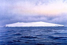
Various explanations for Morrell's error have been suggested, including intentional deception. However, Morrell describes his find briefly and prosaically, evidently seeking no personal credit or glory from the discovery. In his narrative he assigns the honour to his fellow sealing captain, Robert Johnson, for finding and naming the land two years earlier. Morrell may have been honestly mistaken, through miscalculation of his ship's position or by misremembering detail when writing the account after nine years. Alternatively, he may have made the common error of confusing distant icebergs with land, or been misled by the distorting effects of Antarctic mirage
Fata Morgana (mirage)
A Fata Morgana is an unusual and very complex form of mirage, a form of superior mirage, which, like many other kinds of superior mirages, is seen in a narrow band right above the horizon...
. In 1843 the distinguished British naval explorer James Clark Ross
James Clark Ross
Sir James Clark Ross , was a British naval officer and explorer. He explored the Arctic with his uncle Sir John Ross and Sir William Parry, and later led his own expedition to Antarctica.-Arctic explorer:...
reported possible land in a position close to Morrell's; this land, too, would eventually be proven not to exist.
First phase, June 1822 to March 1823
In the early 19th century the geography of Antarctica was almost completely unknown, though occasional sightings of land had been recorded. In 1822 Benjamin Morrell, who had sailed to the South Sandwich Islands the previous year, was appointed commander of the schooner Wasp for a two-year voyage of sealing, trading and exploration in the Antarctic seas and the southern Pacific Ocean. In addition to his sealing duties Morrell had, as he put it, "discretionary powers to prosecute new discoveries." He proposed to use this discretion to investigate the Antarctic seas "and to ascertain the practicality ... of penetrating to the South PoleSouth Pole
The South Pole, also known as the Geographic South Pole or Terrestrial South Pole, is one of the two points where the Earth's axis of rotation intersects its surface. It is the southernmost point on the surface of the Earth and lies on the opposite side of the Earth from the North Pole...
." This would be the first of four extended voyages that would keep Morrell at sea for most of the following eight years, although he would not revisit the Antarctic after the initial voyage.
Wasp sailed south from New York
New York City
New York is the most populous city in the United States and the center of the New York Metropolitan Area, one of the most populous metropolitan areas in the world. New York exerts a significant impact upon global commerce, finance, media, art, fashion, research, technology, education, and...
on 1822. She reached the Falkland Islands
Falkland Islands
The Falkland Islands are an archipelago in the South Atlantic Ocean, located about from the coast of mainland South America. The archipelago consists of East Falkland, West Falkland and 776 lesser islands. The capital, Stanley, is on East Falkland...
late in October, after which Morrell spent 16 days in fruitless searches for the nonexistent Aurora Islands
Aurora Islands
The Aurora Islands was a group of three phantom islands first reported in 1762 by the Spanish merchant ship Aurora while sailing from Lima to Cádiz. The Aurora's officers reported sighting them again in 1774. The Spanish ship San Miguel fixed their location at 52°37'S, 47°49'W...
, before heading for South Georgia, where the ship anchored on . In his account Morrell wrongly records the position of this anchorage, placing it in open sea about 60 miles (96.6 km) south-west of the island's coastline. Wasp subsequently headed eastwards to hunt for seals and, according to Morrell, reached the remote Bouvet Island
Bouvet Island
Bouvet Island is an uninhabited Antarctic volcanic island in the South Atlantic Ocean, 2,525 km south-southwest of South Africa. It is a dependent territory of Norway and, lying north of 60°S latitude, is not subject to the Antarctic Treaty. The centre of the island is an ice-filled crater of an...
on , finding this elusive island without apparent difficulty. Historian H.R. Mill notes that Morrell's description of the island's physical features fails to mention the island's most singular characteristic—it is covered by a permanent ice sheet. He then attempted to take the ship southwards but, reaching thick ice at around 60°S, turned northeast towards the Kerguelen Islands
Kerguelen Islands
The Kerguelen Islands , also known as the Desolation Islands, are a group of islands in the southern Indian Ocean constituting the emerged part of the otherwise submerged Kerguelen Plateau. The islands, along with Adélie Land, the Crozet Islands and the Amsterdam and Saint Paul Islands are part of...
where he anchored on .
Candlemas Island
Candlemas Island is a small uninhabited island of the Candlemas Islands in the South Sandwich Islands. It lies about from Vindication Island, separated by the Nelson Channel....
in the South Sandwich Islands. After a few days spent in a search for fuel to feed the ship's stoves Wasp sailed southwards on , into the area later known as the Weddell Sea. Finding the sea remarkably free of ice, Morrell advanced to 70°14'S before turning north-westward on . This retreat, Morrell says, was due to the ship's lack of fuel; otherwise, he claims, in these open waters he could have taken the ship to 85°, or perhaps to the Pole itself. These words are very similar to those used by the British explorer James Weddell
James Weddell
James Weddell was a British sailor, navigator and seal hunter who in the early Spring of 1823 sailed to latitude of 74°15' S and into a region of the Southern Ocean that later became known as the Weddell Sea.-Early life:He entered the merchant service very...
to describe his own experiences in the same area, a month earlier, which has led historians to suspect that Morrell may have plagiarised Weddell's experiences.
Sighting of land
Antarctic Peninsula
The Antarctic Peninsula is the northernmost part of the mainland of Antarctica. It extends from a line between Cape Adams and a point on the mainland south of Eklund Islands....
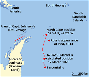
in 1821, calling it "New South Greenland". Morrell's casual reference to Johnson indicates that he assumed the land he was now seeing was the east coast of the peninsula, the geographical character and dimensions of which were not then known (his actual position was about 14° east of the peninsula). Morrell describes seal hunting activities continuing along this putative coast during the remainder of the day. On the following morning sealing resumed as the ship moved slowly southward, and continued until Morrell called a halt "because of shortage of water and season far advanced". Mountains of snow, he observed, could be discerned about 75 miles (120.7 km) further south.
Morrell turned north from a position he calculated as 67°52'S, 48°11'W. Three days later, on , the ship passed what he took to be the northern cape of the land, at 62°41'S, 47°21'W. "This land abounds with oceanic birds of every description", wrote Morrell. He also records seeing 3,000 sea elephants. At 10 o'clock Wasp "bade farewell to the cheerless shores of New South Greenland"; there is no further mention of it in the long voyage account. Wasp sailed for Tierra del Fuego
Tierra del Fuego
Tierra del Fuego is an archipelago off the southernmost tip of the South American mainland, across the Strait of Magellan. The archipelago consists of a main island Isla Grande de Tierra del Fuego divided between Chile and Argentina with an area of , and a group of smaller islands including Cape...
, then through the Magellan Strait into the Pacific Ocean, reaching Valparaiso
Valparaíso
Valparaíso is a city and commune of Chile, center of its third largest conurbation and one of the country's most important seaports and an increasing cultural center in the Southwest Pacific hemisphere. The city is the capital of the Valparaíso Province and the Valparaíso Region...
, Chile, on 1823.
From the first navigations of the Southern Ocean in the 16th century, lands which subsequently proved to be nonexistent had from time to time been reported in these waters. Polar historian Robert Headland of the Scott Polar Research Institute
Scott Polar Research Institute
The Scott Polar Research Institute is a centre for research into the polar regions and glaciology worldwide. It is a sub-department of the Department of Geography in the University of Cambridge, located on Lensfield Road in the south of Cambridge ....
has suggested various reasons for these false sightings, ranging from "too much rum
Rum
Rum is a distilled alcoholic beverage made from sugarcane by-products such as molasses, or directly from sugarcane juice, by a process of fermentation and distillation. The distillate, a clear liquid, is then usually aged in oak barrels...
" to deliberate hoaxes designed to lure rival ships away from good sealing grounds. Some may have been of large ice masses that were carrying rocks and other glacial debris
Moraine
A moraine is any glacially formed accumulation of unconsolidated glacial debris which can occur in currently glaciated and formerly glaciated regions, such as those areas acted upon by a past glacial maximum. This debris may have been plucked off a valley floor as a glacier advanced or it may have...
—dirty ice can appear convincingly similar to land. It is also possible that some of these lands existed, but later became submerged after volcanic eruptions. Other sightings may have been of actual land, wrongly located through observational errors due to chronometer failure, adverse weather or simple incompetence.
Searches for Morrell's land
Jules Dumont d'Urville
Jules Sébastien César Dumont d'Urville was a French explorer, naval officer and rear admiral, who explored the south and western Pacific, Australia, New Zealand and Antarctica.-Childhood:Dumont was born at Condé-sur-Noireau...
sailed over the position of Morrell's "north cape", but saw no indication of land. This evidence, and the general nature of Morrell's account—its obvious errors, and his reputation as a braggart "as great ... as any hero of autobiographical romance" in the words of British geographer Hugh Robert Mill
Hugh Robert Mill
Hugh Robert Mill was a Scottish geographer and meteorologist who was influential in the reform of geography teaching, and in the development of meteorology as a science. Educated in Scotland, he graduated from the University of Edinburgh in 1883...
, led many geographers thereafter to ignore his claims. This scepticism remained even after Sir James Clark Ross reported an appearance of land in 1843, not far from Morrell's alleged observation: Ross's sighting was occasionally proffered as supportive of Morrell's claim. There was no further penetration of the Weddell Sea until 1903, when William Speirs Bruce
William Speirs Bruce
William Speirs Bruce was a London-born Scottish naturalist, polar scientist and oceanographer who organised and led the Scottish National Antarctic Expedition to the South Orkney Islands and the Weddell Sea. Among other achievements, the expedition established the first permanent weather station...
took Scotia to 74°1'S, but in a sector of the sea which did not bring him close to Morrell's or Ross's sightings. Bruce was, however, generally well-disposed towards Morrell, writing that his claims should not be rejected until absolutely disproved.
The first determined search for New South Greenland came during the Second German Antarctic Expedition, 1911–13, under Wilhelm Filchner. The expedition's ship, Deutschland, had become trapped in heavy sea ice while attempting to establish a shore base at Vahsel Bay
Vahsel Bay
Vahsel Bay is a bay about 7 miles wide in the western part of the Luitpold Coast, Antarctica.This bay receives the flow of the Schweitzer Glacier and Lerchenfeld Glacier. It was discovered by the German Antarctic Expedition of 1911–1912, led by Wilhelm Filchner...
. Her subsequent north-westerly drift had, by mid-, brought her to a position 37 miles (59.5 km) east of Morrell's recorded sighting. Filchner left the ship on and, with two companions and sufficient provisions for three weeks, sledged westward across the sea ice in search of Morrell's land. Daylight was limited to two or three hours a day, and temperatures fell to −31 °F (−35 °C), making travel difficult. In these conditions the group covered 31 miles (49.9 km), taking frequent sightings. They found no signs of land; a lead weight dropped through the ice reached a depth of 5248 feet (1,599.6 m) before the line snapped, a depth which confirmed there was no land in the vicinity. Filchner concluded that what Morrell had seen had been a mirage.
On 17 August 1915 Sir Ernest Shackleton's ship Endurance, trapped in the ice like Deutschland three years earlier, drifted to a point 10 miles west of Morrell's charted position. Here, a depth sounding recorded 1,676 fathoms (10,060 feet, 3,065 m), leading Shackleton to write: "I decided that Morrell Land must be added to the long list of Antarctic islands and continental coasts that have resolved themselves into icebergs". On a further sounding of 1,900 fathoms (11,400 feet, 3,500 m) gave Shackleton additional evidence of the non-existence of New South Greenland.
Although Filchner's and Shackleton's investigations and observations were accepted as conclusive proof that New South Greenland was a myth, there remained the question of Sir James Ross's reported appearance of land in a position around 65°S, 47°W. Ross's reputation was sufficient for this possibility to be taken seriously, and for his alleged sighting to be recorded on maps and Admiralty charts. In 1922 Frank Wild
Frank Wild
Commander John Robert Francis Wild CBE, RNVR, FRGS , known as Frank Wild, was an explorer...
, leading the Shackleton-Rowett Expedition
Shackleton-Rowett Expedition
The Shackleton–Rowett Expedition was Sir Ernest Shackleton's last Antarctic project, and the final episode in the Heroic Age of Antarctic Exploration. The venture, financed by businessman John Quiller Rowett, is sometimes referred to as the Quest Expedition after its ship Quest, a converted...
aboard Quest after Shackleton's death early in the expedition, investigated the location of Ross's sighting. Nothing was seen; prevented by ice conditions from reaching the exact spot, Wild took a sounding at 64°11'S, 46°4'W, which revealed 2331 fathom (13,986 ft; 4,263 m) of water. This showed that no land was near.
Opinions and theories
Hugh Robert Mill, writing in 1905 before the non-existence of New South Greenland had been proved conclusively, refers to the sheer absurdity of some of the incidents described in Morrell's account, and concludes that because of Morrell's blunders, and his habit of incorporating the experiences of others into his story, all his claims must be treated as not proven. Nevertheless he concedes that "a man may be ignorant, boastful and obscure, and yet have done a solid piece of work". Canadian geographer Paul Simpson-Housley adopts a more sympathetic approach. Although dubious about much of Morrell's account, Simpson-Housley suggests that the speeds claimed for the western journey, though fast, are not impossible. He believes that the claimed farthest south in the Weddell Sea, queried by Mill, is entirely plausible, given that James Weddell had sailed four degrees further south just a month earlier.
Another inclined to defend Morrell's integrity is the writer Rupert Gould, who included a lengthy essay on New South Greenland in his collection Enigmas, published in 1929. The assumption that the New South Greenland sighting was simply invented by Morrell is dismissed, primarily on the grounds of the very little weight given to the discovery in Morrell's 500-page account. Gould writes: "If Morrell wished to gain an undeserved reputation as an Antarctic explorer, one would think he could have gone a better way about it than to bury his pièces justificatives, after he had forged them, in an undistinguished corner of so bulky a book." In the relatively few pages devoted to the Antarctic, Morrell's account of his discovery is brief and entirely matter-of-fact, crediting it to Captain Johnson two years earlier rather than to himself.
Graham Land
Graham Land is that portion of the Antarctic Peninsula which lies north of a line joining Cape Jeremy and Cape Agassiz. This description of Graham Land is consistent with the 1964 agreement between the British Antarctic Place-names Committee and the US Advisory Committee on Antarctic Names, in...
, the so-called "Foyn Coast
Foyn Coast
Foyn Coast is that portion of the east coast of the Antarctic Peninsula between Cape Alexander and Cape Northrop. Discovered in 1893 by a Norwegian expedition under Captain Carl Anton Larsen, who named it for Svend Foyn, Norwegian whaler of Tønsberg whose invention of the grenade harpoon greatly...
", despite its being 14° further west from position of the New South Greenland sighting. In support, Gould asserts that the peninsula's eastern coast corresponds very closely with the stretch of coastline described by Morrell. This theory supposes that Morrell miscalculated the ship's position, perhaps because he lacked the chronometer necessary for proper navigational observation. In his account Morrell writes that he was "destitute of the various nautical and mathematical instruments", but other parts of his narrative make it clear that the occasional dead reckoning
Dead reckoning
In navigation, dead reckoning is the process of calculating one's current position by using a previously determined position, or fix, and advancing that position based upon known or estimated speeds over elapsed time, and course...
calculation was the exception to the norm. In any circumstances a longitudinal error of 14° is very large, and the additional distance of about 350 miles (563.3 km) to the Foyn coast seems too great to have been covered within the ten-day voyage from the South Sandwich Islands, where the ship's position is recorded accurately. Even so, Gould maintains that a "balance of evidence" shows that what Morrell saw was the Foyn coast.
Fata Morgana (mirage)
A Fata Morgana is an unusual and very complex form of mirage, a form of superior mirage, which, like many other kinds of superior mirages, is seen in a narrow band right above the horizon...
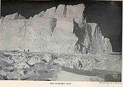
, distorts distant flat coastlines or ice edges both vertically and horizontally, so they can appear to have tall cliffs and other features such as high mountain peaks and valleys. In his expedition account South, Shackleton gives a description of a Fata Morgana observed on 1915, coincidentally as his ship Endurance drifted close to the recorded position of New South Greenland: "The distant pack is thrown up into towering barrier-like cliffs, which are reflected in blue lakes and lanes of water at their base. Great white and golden cities of Oriental appearance at close intervals along these cliff-tops indicate distant bergs ... The lines rise and fall, tremble, dissipate, and reappear in an endless transformation scene".
Afterwards
Morrell's four voyages finally ended on 1831, with his return to New York. He then wrote his Narrative of Four Voyages, which was published the following year. He attempted to resume his seafaring career, seeking employment with the London-based shipping firm of Enderby Brothers, but his reputation had preceded him and he was rejected. Charles Enderby stated publicly that "he had heard so much of him that he did not think fit to enter into any engagement with him." Morrell also sought to join Dumont D'Urville's expedition to the Weddell Sea in 1837, but his services were again declined. He reportedly died in 1839, and is commemorated by Morrell IslandThule Island
Thule Island, also called Morrell Island, is one of the southernmost of the South Sandwich Islands, part of the grouping known as Southern Thule. It is named, on account of its remote location, after the mythical land of Thule, said by ancient geographers to lie at the extreme end of the earth...
, 59°27'S, 27°19'W, an alternative name for Thule Island in the Southern Thule
Southern Thule
Southern Thule is a collection of the three southernmost islands in the South Sandwich Islands: Bellingshausen, Cook, and Thule . Southern Thule is British territory, though claimed by Argentina. The island group is barren, windswept, bitterly cold, and uninhabited. It has an extenzive EEZ rich...
sub-group of the South Sandwich Islands. Robert Johnson, who coined the name New South Greenland, disappeared with his ship in 1826, while investigating the Antarctic waters in the vicinity of what would later be known as the Ross Sea
Ross Sea
The Ross Sea is a deep bay of the Southern Ocean in Antarctica between Victoria Land and Marie Byrd Land.-Description:The Ross Sea was discovered by James Ross in 1841. In the west of the Ross Sea is Ross Island with the Mt. Erebus volcano, in the east Roosevelt Island. The southern part is covered...
.