

South Shetland Islands
Unanswered Questions
Encyclopedia

Antarctic Peninsula
The Antarctic Peninsula is the northernmost part of the mainland of Antarctica. It extends from a line between Cape Adams and a point on the mainland south of Eklund Islands....
, with a total area of 3687 square kilometres (1,423.6 sq mi). By the Antarctic Treaty
Antarctic Treaty System
The Antarctic Treaty and related agreements, collectively called the Antarctic Treaty System or ATS, regulate international relations with respect to Antarctica, Earth's only continent without a native human population. For the purposes of the treaty system, Antarctica is defined as all of the land...
of 1959, the Islands' sovereignty is neither recognized nor disputed by the signatories and they are free for use by any signatory for non-military purposes.
The islands have been claimed by the United Kingdom
United Kingdom
The United Kingdom of Great Britain and Northern IrelandIn the United Kingdom and Dependencies, other languages have been officially recognised as legitimate autochthonous languages under the European Charter for Regional or Minority Languages...
since 1908 and have been part of the British Antarctic Territory
British Antarctic Territory
The British Antarctic Territory is a sector of Antarctica claimed by the United Kingdom as one of its 14 British Overseas Territories. It comprises the region south of 60°S latitude and between longitudes and , forming a wedge shape that extends to the South Pole...
since 1962. They are also claimed by the governments of Chile
Chile
Chile ,officially the Republic of Chile , is a country in South America occupying a long, narrow coastal strip between the Andes mountains to the east and the Pacific Ocean to the west. It borders Peru to the north, Bolivia to the northeast, Argentina to the east, and the Drake Passage in the far...
(since 1940, as part of the Antártica Chilena Province
Antártica Chilena Province
Antártica Chilena Province is the southernmost and one of four provinces in Chile's southernmost region, Magallanes and Antártica Chilena Region . The capital is Puerto Williams...
) and by Argentina
Argentina
Argentina , officially the Argentine Republic , is the second largest country in South America by land area, after Brazil. It is constituted as a federation of 23 provinces and an autonomous city, Buenos Aires...
(since 1943, as part of Argentine Antarctica
Argentine Antarctica
Argentine Antarctica is a sector of Antarctica claimed by Argentina as part of its national territory. The Argentine Antarctic region, consisting of the Antarctic Peninsula and a triangular section extending to the South Pole, is delimited by the 25° West and 74° West meridians and the 60° South...
, Tierra del Fuego Province).
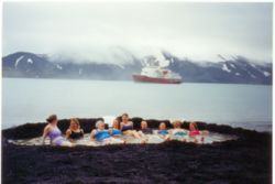
Several countries maintain research stations on the Islands. Most of them are situated on King George Island, benefitting from the airfield of the Chilean base Eduardo Frei.
There are sixteen research stations to date in different parts of the islands, with Chilean stations being the greatest in number. Research is often a shared duty of nations, with Chilean-American Shirreff Base
Shirreff Base
Shirreff Base is a seasonal field station operated by Chile and the USA opened in 1991. Situated on the east side of Cape Shirreff on Ioannes Paulus II Peninsula on Livingston Island in the South Shetland Islands.-Location:...
being an example of this.
History
The Dutchman Dirck GerritszDirck Gerritz Pomp
Dirck Gerritszoon Pomp, alias Dirck China was a Dutch sailor of the 16th-17th century, and the first known Dutchman to visit Japan....
in 1599, or the Spaniard Gabriel de Castilla
Gabriel de Castilla
Gabriel de Castilla , was a Spanish explorer and navigator. A native of Palencia, he was an early explorer of Antarctica. His contribution to knowledge of the Antarctic continent was ignored in his lifetime and long afterwards...
in 1603 supposedly sailed south of the Drake Passage
Drake Passage
The Drake Passage or Mar de Hoces—Sea of Hoces—is the body of water between the southern tip of South America at Cape Horn, Chile and the South Shetland Islands of Antarctica...
in the South Shetland Islands area. In 1818 Juan Pedro de Aguirre obtained permission from the Buenos Aires
Buenos Aires
Buenos Aires is the capital and largest city of Argentina, and the second-largest metropolitan area in South America, after São Paulo. It is located on the western shore of the estuary of the Río de la Plata, on the southeastern coast of the South American continent...
authorities to install an establishment for sealing on "some of the uninhabited islands near the South Pole".
Captain William Smith
William Smith (mariner)
William Smith was the English captain who discovered the South Shetland Islands, an archipelago off the Graham Land in Antarctica....
in the British merchant brig Williams, while sailing to Valparaiso
Valparaíso
Valparaíso is a city and commune of Chile, center of its third largest conurbation and one of the country's most important seaports and an increasing cultural center in the Southwest Pacific hemisphere. The city is the capital of the Valparaíso Province and the Valparaíso Region...
, Chile
Chile
Chile ,officially the Republic of Chile , is a country in South America occupying a long, narrow coastal strip between the Andes mountains to the east and the Pacific Ocean to the west. It borders Peru to the north, Bolivia to the northeast, Argentina to the east, and the Drake Passage in the far...
in 1819 deviated from his route south of Cape Horn
Cape Horn
Cape Horn is the southernmost headland of the Tierra del Fuego archipelago of southern Chile, and is located on the small Hornos Island...
, and on 19 February sighted Williams Point
Williams Point
Williams Point is the point forming both the north extremity of Varna Peninsula and the northeast tip of Livingston Island in the South Shetland Islands, Antarctica...
, the northeast extremity of Livingston Island. Thus Livingston Island became the first land ever discovered south of the 60th southern latitude. Smith revisited the South Shetlands, landed on King George Island on 16 October 1819, and claimed possession for Britain
United Kingdom of Great Britain and Ireland
The United Kingdom of Great Britain and Ireland was the formal name of the United Kingdom during the period when what is now the Republic of Ireland formed a part of it....
.
Meanwhile, the Spanish Navy ship San Telmo
San Telmo (ship)
San Telmo was a Spanish 74-gun ship of the line, launched in 1788.In 1819 the San Telmo commanded by Captain Rosendo Porlier was the flagship of a Spanish naval squadron bound for Callao to reinforce colonial forces there fighting the independence movements in Spanish America...
sank in September 1819 whilst trying to go through the Drake Passage. Parts of her supposed wreckage were found months later by sealers on the north coast of Livingston Island.
During December 1819 - January 1820 the islands were surveyed and mapped by Lieutenant Edward Bransfield
Edward Bransfield
Edward Bransfield was a master of the British Royal Navy and considered the discoverer of the continent of Antarctica.-Early life:...
onboard the Williams, with the ship chartered by the Royal Navy
Royal Navy
The Royal Navy is the naval warfare service branch of the British Armed Forces. Founded in the 16th century, it is the oldest service branch and is known as the Senior Service...
.
Already on 15 November 1819 the American agent in Valparaíso
Valparaíso
Valparaíso is a city and commune of Chile, center of its third largest conurbation and one of the country's most important seaports and an increasing cultural center in the Southwest Pacific hemisphere. The city is the capital of the Valparaíso Province and the Valparaíso Region...
, Jeremy Robinson, informed the US Secretary of State John Quincy Adams
John Quincy Adams
John Quincy Adams was the sixth President of the United States . He served as an American diplomat, Senator, and Congressional representative. He was a member of the Federalist, Democratic-Republican, National Republican, and later Anti-Masonic and Whig parties. Adams was the son of former...
of Smith’s discovery and Bransfield’s forthcoming mission, and suggested the dispatch of a US government ship to explore the islands where "new sources of wealth, power and happiness would be disclosed and science itself be benefited thereby."
The discovery of the islands attracted British and American sealers.
The first sealing ship to operate in the area was the brig Espirito Santo chartered by British merchants in Buenos Aires. The ship arrived at Rugged Island
Rugged Island (South Shetland Islands)
Rugged Island is an island long and wide, lying west of Livingston Island in the South Shetland Islands. Surface area . The island's summit San Stefano Peak rises to above sea level. Rugged Island is located at...
off Livingston Island, where its British crew landed on Christmas Day 1819, and claimed the islands for King George III; a narrative of the events was published by the brig's master Joseph Herring in the July 1820 edition of the Imperial Magazine. The Espirito Santo was followed from the Falkland Islands
Falkland Islands
The Falkland Islands are an archipelago in the South Atlantic Ocean, located about from the coast of mainland South America. The archipelago consists of East Falkland, West Falkland and 776 lesser islands. The capital, Stanley, is on East Falkland...
by the American brig Hersilia commanded by Captain James Sheffield (with second mate Nathaniel Palmer
Nathaniel Palmer
Nathaniel Brown Palmer was an American seal hunter, explorer, sailing captain, and ship designer. He was born in Stonington, Connecticut.-Sealing career and Antarctic exploration:...
), the first American sealer in the South Shetlands.
The first overwintering in Antarctica took place on the South Shetlands, when at the end of the 1820/21 summer season eleven British men from the ship Lord Melville failed to leave King George Island, and survived successfully throughout the austral winter to be rescued at the beginning of the next season.
Having circumnavigated the Antarctic continent, the Russian Antarctic expedition of Fabian von Bellingshausen
Fabian Gottlieb von Bellingshausen
Fabian Gottlieb Thaddeus von Bellingshausen was an officer in the Imperial Russian Navy, cartographer and explorer, who ultimately rose to the rank of Admiral...
and Mikhail Lazarev
Mikhail Petrovich Lazarev
Admiral Mikhail Petrovich Lazarev was a Russian fleet commander and explorer who discovered Antarctica.-Education and early career:Lazarev was born in Vladimir, a scion of the old Russian nobility from the Vladimir province. In 1800, he enrolled in Russia's Naval College. Three years later he...
arrived to the South Shetlands in January 1821. The Russians surveyed the islands and named them, landing on both King George Island and Elephant Island
Elephant Island (South Shetland Islands)
Elephant Island is an ice-covered, mountainous island off the coast of Antarctica in the outer reaches of the South Shetland Islands in the Southern Ocean. Its name was given by early explorers sighting elephant seals on its shores. It lies west-southwest of South Georgia, south of the Falkland...
. While sailing between Deception
Deception Island (South Shetland Islands)
Deception Island is an island in South Shetland off the Antarctic Peninsula, which has one of the safest harbours in Antarctica. The island is the caldera of an active volcano, which caused serious damage to the local scientific stations in 1967 and 1969...
and Livingston
Livingston Island (South Shetland Islands)
Livingston Island is an Antarctic island in the South Shetland Islands, Western Antarctica lying between Greenwich Island and Snow Islands...
islands, Bellingshausen was visited by Nathaniel Palmer
Nathaniel Palmer
Nathaniel Brown Palmer was an American seal hunter, explorer, sailing captain, and ship designer. He was born in Stonington, Connecticut.-Sealing career and Antarctic exploration:...
, master of the American brig Hero, who informed him of the activities of dozens of American and British sealing ships in the area.
The name "New South Britain" was used briefly, but was soon changed to South Shetland Islands (in reference to the Shetland Islands
Shetland Islands
Shetland is a subarctic archipelago of Scotland that lies north and east of mainland Great Britain. The islands lie some to the northeast of Orkney and southeast of the Faroe Islands and form part of the division between the Atlantic Ocean to the west and the North Sea to the east. The total...
off the northern coast of Scotland
Scotland
Scotland is a country that is part of the United Kingdom. Occupying the northern third of the island of Great Britain, it shares a border with England to the south and is bounded by the North Sea to the east, the Atlantic Ocean to the north and west, and the North Channel and Irish Sea to the...
). The name South Shetland Islands is now established in international usage. Both sets of islands actually lie at a similar distance from the South Pole and North Pole respectively, but the South Shetlands are much colder (see below).
Seal hunting
Seal hunting
Seal hunting, or sealing, is the personal or commercial hunting of seals. The hunt is currently practiced in five countries: Canada, where most of the world's seal hunting takes place, Namibia, the Danish region of Greenland, Norway and Russia...
and whaling
Whaling
Whaling is the hunting of whales mainly for meat and oil. Its earliest forms date to at least 3000 BC. Various coastal communities have long histories of sustenance whaling and harvesting beached whales...
was done on the islands during the 19th and early 20th century. From 1908 the islands were governed as part of the Falkland Islands Dependency
Falkland Islands
The Falkland Islands are an archipelago in the South Atlantic Ocean, located about from the coast of mainland South America. The archipelago consists of East Falkland, West Falkland and 776 lesser islands. The capital, Stanley, is on East Falkland...
but the islands have only been occupied since the establishment of a scientific research station during 1944. The archipelago, together with the nearby Antarctic Peninsula
Antarctic Peninsula
The Antarctic Peninsula is the northernmost part of the mainland of Antarctica. It extends from a line between Cape Adams and a point on the mainland south of Eklund Islands....
and South Georgia, is an increasingly popular tourist
Tourism
Tourism is travel for recreational, leisure or business purposes. The World Tourism Organization defines tourists as people "traveling to and staying in places outside their usual environment for not more than one consecutive year for leisure, business and other purposes".Tourism has become a...
destination during the austral summer.
Geography
As a group of islands, the South Shetland Islands are located at 62°0′S 58°0′W. They are within the region 61° 00'–63° 37' South, 53° 83'–62° 83' West. The islands lie 940 km (584.1 mi) south of the Falkland IslandsFalkland Islands
The Falkland Islands are an archipelago in the South Atlantic Ocean, located about from the coast of mainland South America. The archipelago consists of East Falkland, West Falkland and 776 lesser islands. The capital, Stanley, is on East Falkland...
, and between 93 km (57.8 mi) (Deception Island) and 269 km (167.1 mi) (Clarence Island
Clarence Island (South Shetland Islands)
Clarence Island is long and the easternmost of the South Shetland Islands of the British Antarctic Territory. The name dates back to at least 1821 and is now established in international usage. Ernest Shackleton saw Clarence Island on his famous boat voyage but landed on Elephant Island...
) northwest and north from the nearest point of the Antarctic continent, Graham Land.
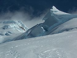
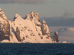
The South Shetlands consist of 11 major islands and several minor ones, totalling 3687 square kilometres (1,423.6 sq mi) of land area. Between 80 and 90 percent of the land area is permanently glaciated
Glacier
A glacier is a large persistent body of ice that forms where the accumulation of snow exceeds its ablation over many years, often centuries. At least 0.1 km² in area and 50 m thick, but often much larger, a glacier slowly deforms and flows due to stresses induced by its weight...
. The highest point on the island chain is Mount Irving
Mount Irving
Mount Irving is a mountain rising to ca. that is the dominant elevation in the southern part of Clarence Island, in the South Shetland Islands. A prominent feature, the mountain doubtless was known to sealers in the area in the 1820s. Named by United Kingdom Antarctic Place-Names Committee for...
on Clarence Island at 2300 metres (7,546 ft) above sea level.
The South Shetland Islands extend about 450 km (279.6 mi) from Smith Island
Smith Island (South Shetland Islands)
Smith Island is long and wide, lying west of Deception Island in the South Shetland Islands of the British Antarctic Territory. Surface area ....
and Snow Island
Snow Island (South Shetland Islands)
Snow Island or Isla Nevada is a completely ice-covered island, in size, lying southwest of Livingston Island in the South Shetland Islands. Surface area...
in the west-southwest to Elephant Island
Elephant Island (South Shetland Islands)
Elephant Island is an ice-covered, mountainous island off the coast of Antarctica in the outer reaches of the South Shetland Islands in the Southern Ocean. Its name was given by early explorers sighting elephant seals on its shores. It lies west-southwest of South Georgia, south of the Falkland...
and Clarence Island
Clarence Island (South Shetland Islands)
Clarence Island is long and the easternmost of the South Shetland Islands of the British Antarctic Territory. The name dates back to at least 1821 and is now established in international usage. Ernest Shackleton saw Clarence Island on his famous boat voyage but landed on Elephant Island...
in the east-northeast.
Climate
The islands are the same distance from the equator as the Faroe islandsFaroe Islands
The Faroe Islands are an island group situated between the Norwegian Sea and the North Atlantic Ocean, approximately halfway between Scotland and Iceland. The Faroe Islands are a self-governing territory within the Kingdom of Denmark, along with Denmark proper and Greenland...
in the north Atlantic but their proximity to Antarctica means that they have a much colder climate. The sea around the islands is closed by ice
Sea ice
Sea ice is largely formed from seawater that freezes. Because the oceans consist of saltwater, this occurs below the freezing point of pure water, at about -1.8 °C ....
from early April to early December and the monthly average temperature is below 0 °C (32 °F) for eight months of the year (April 1 to November).
The islands have experienced measurable glacier
Glacier
A glacier is a large persistent body of ice that forms where the accumulation of snow exceeds its ablation over many years, often centuries. At least 0.1 km² in area and 50 m thick, but often much larger, a glacier slowly deforms and flows due to stresses induced by its weight...
retreat during recent years but despite this they remain more than 80% snow and ice covered throughout the summer.
The climate is cloudy and humid all year round and very strong westerly winds blow at all seasons. Some of the sunniest weather is associated with outbreaks of very cold weather from the south in late winter and spring. Mean summer temperatures are only about 1.5 °C (34.7 °F) and those in winter are about -5 °C. The effect of the ocean tends to keep summer temperatures low and winter temperatures from decreasing as low as they do inland to the south.
Flora and fauna
Despite the harsh conditions the islands do support vegetation and are part of the Scotia SeaScotia Sea
The Scotia Sea is partly in the Southern Ocean and mostly in the South Atlantic Ocean.-Location and description:Habitually stormy and cold, the Scotia Sea is the area of water between Tierra del Fuego, South Georgia, South Sandwich Islands, South Orkney Islands and the Antarctic Peninsula, and...
Islands tundra
Tundra
In physical geography, tundra is a biome where the tree growth is hindered by low temperatures and short growing seasons. The term tundra comes through Russian тундра from the Kildin Sami word tūndâr "uplands," "treeless mountain tract." There are three types of tundra: Arctic tundra, alpine...
ecoregion
Ecoregion
An ecoregion , sometimes called a bioregion, is an ecologically and geographically defined area that is smaller than an ecozone and larger than an ecosystem. Ecoregions cover relatively large areas of land or water, and contain characteristic, geographically distinct assemblages of natural...
, along with South Georgia and the South Sandwich Islands
South Georgia and the South Sandwich Islands
South Georgia and the South Sandwich Islands is a British overseas territory and overseas territory of the European Union in the southern Atlantic Ocean. It is a remote and inhospitable collection of islands, consisting of South Georgia and a chain of smaller islands, known as the South Sandwich...
, the South Orkney Islands
South Orkney Islands
The South Orkney Islands are a group of islands in the Southern Ocean, about north-east of the tip of the Antarctic Peninsula. They have a total area of about ....
and Bouvet Island
Bouvet Island
Bouvet Island is an uninhabited Antarctic volcanic island in the South Atlantic Ocean, 2,525 km south-southwest of South Africa. It is a dependent territory of Norway and, lying north of 60°S latitude, is not subject to the Antarctic Treaty. The centre of the island is an ice-filled crater of an...
. All these islands lie in the cold seas below the Antarctic convergence
Antarctic Convergence
The Antarctic Convergence is a curve continuously encircling Antarctica where cold, northward-flowing Antarctic waters meet the relatively warmer waters of the subantarctic. Antarctic waters predominantly sink beneath subantarctic waters, while associated zones of mixing and upwelling create a zone...
. These areas support tundra vegetation consisting of moss
Moss
Mosses are small, soft plants that are typically 1–10 cm tall, though some species are much larger. They commonly grow close together in clumps or mats in damp or shady locations. They do not have flowers or seeds, and their simple leaves cover the thin wiry stems...
es, lichen
Lichen
Lichens are composite organisms consisting of a symbiotic organism composed of a fungus with a photosynthetic partner , usually either a green alga or cyanobacterium...
s and algae
Algae
Algae are a large and diverse group of simple, typically autotrophic organisms, ranging from unicellular to multicellular forms, such as the giant kelps that grow to 65 meters in length. They are photosynthetic like plants, and "simple" because their tissues are not organized into the many...
, while seabirds, penguins and seals feed in the surrounding waters.
Islands
- Cornwallis IslandCornwallis Island (South Shetland Islands)Cornwallis Island is an island long, which lies northeast of the east end of Elephant Island, in the South Shetland Islands. The name Cornwallis Island dates back to about 1821 and is now established in international usage.- See also :...
(minor) - Elephant IslandElephant Island (South Shetland Islands)Elephant Island is an ice-covered, mountainous island off the coast of Antarctica in the outer reaches of the South Shetland Islands in the Southern Ocean. Its name was given by early explorers sighting elephant seals on its shores. It lies west-southwest of South Georgia, south of the Falkland...
(Mordvinova by Russia) - Clarence IslandClarence Island (South Shetland Islands)Clarence Island is long and the easternmost of the South Shetland Islands of the British Antarctic Territory. The name dates back to at least 1821 and is now established in international usage. Ernest Shackleton saw Clarence Island on his famous boat voyage but landed on Elephant Island...
(Shishkova by Russia) - Rowett IslandRowett Island (South Shetland Islands)Rowett Island is a rocky island long, lying immediately off Cape Lookout, Elephant Island, in the South Shetland Islands. Rowett Island is located at . Rowett Island was known to both American and British sealers as early as 1822...
(minor) - Gibbs IslandGibbs Island (South Shetland Islands)Gibbs Island southwest of Elephant Island in the South Shetland Islands. James Weddell, Master, Royal Navy, whose chart of the islands appeared in 1825, seems first to have used the present name, which is now established in international usage....
(minor) - Eadie Island (minor)
- King George Island (the largest, called May 25 island by Argentina, or Vaterloo by Russia)
- Bridgeman IslandBridgeman Island (South Shetland Islands)Bridgeman Island or Bridgemans's Island or Bridgman Island or Helena Island is one of the South Shetland Islands. It is an almost circular, volcanic island marked by steep sides, long and high, lying east of King George Island . Bridgeman Island is located at and has an elevation of...
(minor) - Penguin IslandPenguin Island (South Shetland Islands)Penguin Island is an island, wide by long, which lies close off the south coast of King George Island and marks the eastern side of the entrance to King George Bay in the South Shetland Islands...
(minor - one of several Penguin Islands in the Antarctic region, also believed to be the location of the popular online game Club PenguinClub PenguinClub Penguin is a massively multiplayer online role-playing game involving a virtual world containing a range of online games and activities, by Club Penguin Entertainment . Players use cartoon penguin-avatars and play in a winter-set virtual world...
) - Nelson IslandNelson Island (South Shetland Islands)Nelson Island is an island long and wide, lying southwest of King George Island in the South Shetland Islands, Antarctica. Nelson Island is located at...
(Leipzig by Russia) - Robert IslandRobert Island (South Shetland Islands)Robert Island or Mitchells Island or Polotsk Island or Roberts Island is an island long and wide, situated between Nelson Island and Greenwich Island in the South Shetland Islands. Robert Island is located at . Surface area...
(Polotsk by Russia) - Aitcho IslandsAitcho Islands (South Shetland Islands)The Aitcho Islands are a group of minor islands on the west side of the north entrance to English Strait separating Greenwich Island and Robert Island in the South Shetland Islands, Antarctica, which are situated between Dee Island to the south and Table Island to the north...
(minor) - Greenwich IslandGreenwich Island (South Shetland Islands)Greenwich Island is an island long and from wide, lying between Robert Island and Livingston Island in the South Shetland Islands. Surface area...
(Berezina by Russia)
- Half Moon IslandHalf Moon Island (South Shetland Islands)Half Moon Island is a minor Antarctic island, lying north of Burgas Peninsula, Livingston Island in the Antarctic Peninsula region. Surface area ....
(minor) - Desolation IslandDesolation Island (South Shetland Islands)Desolation Island is one of the minor islands in the South Shetlands archipelago, Antarctica situated at the entrance to Hero Bay, Livingston Island. The island is V-shaped with its northern coast indented by Kozma Cove. Surface area ....
(minor) - Livingston IslandLivingston Island (South Shetland Islands)Livingston Island is an Antarctic island in the South Shetland Islands, Western Antarctica lying between Greenwich Island and Snow Islands...
(second largest, Smolensk by Russia) - Rugged IslandRugged Island (South Shetland Islands)Rugged Island is an island long and wide, lying west of Livingston Island in the South Shetland Islands. Surface area . The island's summit San Stefano Peak rises to above sea level. Rugged Island is located at...
(minor - one of several in the Antarctic region) - Snow IslandSnow Island (South Shetland Islands)Snow Island or Isla Nevada is a completely ice-covered island, in size, lying southwest of Livingston Island in the South Shetland Islands. Surface area...
(one of several in the Antarctic region; Maly Yaroslavets by Russia) - Smith IslandSmith Island (South Shetland Islands)Smith Island is long and wide, lying west of Deception Island in the South Shetland Islands of the British Antarctic Territory. Surface area ....
(Borodino by Russia) - Deception IslandDeception Island (South Shetland Islands)Deception Island is an island in South Shetland off the Antarctic Peninsula, which has one of the safest harbours in Antarctica. The island is the caldera of an active volcano, which caused serious damage to the local scientific stations in 1967 and 1969...
(Teylya by Russia) - Low IslandLow Island (South Shetland Islands)Low Island or Isla Baja, historical names Jameson Island or Jamesons Island is an island long and wide, southeast of Smith Island, in the South Shetland Islands. The island is located at and is separated from Smith Island by Osmar Strait. Low Island was so named because of its low elevation...
- Seal IslandSeal Island (South Shetland Islands)Seal Islands are a group of small islands and rocks lying from northwest of Elephant Island in the South Shetland Islands. The Seal Islands are located at...
(minor)
(The Russian names above are historical, and no longer the official Russian names of the relevant islands.)
Research stations
Jubany
Jubany Scientific Station is an Argentine permanent base in the Antarctic located at , first settled in 1953 in the 25 de Mayo island among the South Shetland Islands. It has a maximum population of 60 people...
(since 1953, Year-round) - Base Decepción
Base Decepción
Base Decepción is an Argentine antarctic base located at Deception Island, South Shetland Islands.- History :The station was founded on January 25, 1948, and was a year-round station until December 1967 when volcanic eruptions forced the evacuation of the base...
(since 1948, Summer only) - St. Kliment Ohridski
St. Kliment Ohridski Base
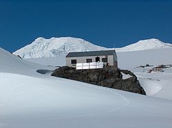
St. Kliment Ohridski Base is a Bulgarian Antarctic base on Livingston Island in the South Shetland Islands.The base, originally known as Sofia University Refuge, was named in 1993 "for St...
(since 1988, Summer only) - Comandante Ferraz Base
Comandante Ferraz Brazilian Antarctic Base
The Comandante Ferraz Brazilian Antarctic Base is a Brazilian research station located in Admiralty Bay, King George Island, near the tip of the Antarctic Peninsula....
(since 1984, Year-round) - Presidente Eduardo Frei Base (since 1969, Year-round) - Professor Julio Escudero Base
Professor Julio Escudero Base
Professor Julio Escudero Base is a permanent Chilean Antarctic research base. It is located on King George Island. It lies within the Antártica Chilean commune funded by the Antarctic Institute of the Ministry of Foreign Relations.-External links:* * *...
(since 1994, Year-round) - Captain Arturo Prat Base
Captain Arturo Prat Base
Captain Arturo Prat Base is a Chilean Antarctic research base located at Iquique Cove, Greenwich Island in the South Shetland Islands, Antarctica. Opened February 6, 1947, it is the oldest Chilean Antarctic station. Until March 1, 2006, it was a base of the Chilean Navy, on which date it was handed...
(since 1947, Year-round)
 United States Chile
Chile
Chile ,officially the Republic of Chile , is a country in South America occupying a long, narrow coastal strip between the Andes mountains to the east and the Pacific Ocean to the west. It borders Peru to the north, Bolivia to the northeast, Argentina to the east, and the Drake Passage in the far...
/USA - Shirreff Base
Shirreff Base
Shirreff Base is a seasonal field station operated by Chile and the USA opened in 1991. Situated on the east side of Cape Shirreff on Ioannes Paulus II Peninsula on Livingston Island in the South Shetland Islands.-Location:...
(since 1990, Summer only) - Chang Cheng / Great Wall (since 1985, Year-round) - Pedro Vicente Maldonado Base (since 1990, Summer only) - Juan Carlos I Base
Juan Carlos I Base
Juan Carlos I Antarctic Base, named after the king of Spain, Juan Carlos I, is a seasonal scientific station operated by Spain, opened in January 1988...
(since 1988, Summer only) - Gabriel de Castilla Base (since 1989, Summer only) - King Sejong Station
King Sejong Station
The King Sejong Station is a research station for the Korea Antarctic Research Program, and it is named after King Sejong the Great of Joseon. Established on February 17th, 1988, it consists of 11 facility buildings and two observatories, and it is located on the Barton Peninsula...
(since 1988, Year-round) - Machu Picchu Research Station (since 1989, Summer only) - Henryk Arctowski Polish Antarctic Station
Henryk Arctowski Polish Antarctic Station
Henryk Arctowski Polish Antarctic Station is a research station on King George Island, off the coast of Antarctica.Named for Henryk Arctowski , who as meteorologist had accompanied the Belgian explorer Baron Adrien de Gerlache on the "Belgica" expedition, 1897-1899. This was the first expedition to...
(since 1977, Year-round) - Bellingshausen Station
Bellingshausen Station
thumb|right|Bellingshausen is one of Antarctica's most polluted places. Old vehicles, rusting barrels and other refuse litter the shorelinethumb|right|Muddy scene around the base. On the hilltop an orthodox church was built in 2004...
(since 1968, Year-round) - Artigas Base
Artigas Base
The General Artigas Station , also referred to as the Artigas Base is a small Uruguayan scientific research station in Antarctica. It is only one of the 68 bases in Antarctica.-Organization:...
(since 1984, Year-round)
Field Camps
- Camp LivingstonCamp Livingston (Antarctica)
Camp Livingston is an Argentine seasonal base camp on Byers Peninsula, Livingston Island in the South Shetland Islands, Antarctica. The area was visited by early 19th century sealers.-Location:...
- Camp Academia
Camp Academia
Camp Academia is a geographical locality in eastern Livingston Island, South Shetland Islands, Antarctica, named for the Bulgarian Academy of Sciences in appreciation of Academy’s contribution to the Antarctic exploration...
- Camp Byers
Camp Byers
Camp Byers is a Spanish seasonal base camp on Byers Peninsula, Livingston Island in the South Shetland Islands, Antarctica. The area was visited by early 19th century sealers.-Location:...
See also
- British Antarctic TerritoryBritish Antarctic TerritoryThe British Antarctic Territory is a sector of Antarctica claimed by the United Kingdom as one of its 14 British Overseas Territories. It comprises the region south of 60°S latitude and between longitudes and , forming a wedge shape that extends to the South Pole...
- Composite Antarctic Gazetteer
- Deception Island
- Greenwich Island
- King George Island
- List of Antarctic and sub-Antarctic islands
- List of Antarctic islands south of 60° S
- Livingston Island
- SCARScarScars are areas of fibrous tissue that replace normal skin after injury. A scar results from the biological process of wound repair in the skin and other tissues of the body. Thus, scarring is a natural part of the healing process. With the exception of very minor lesions, every wound results in...
- Sherratt BaySherratt BaySherratt Bay is a bay between Cape Melville and Penguin Island on the south side of King George Island, in the South Shetland Islands. The existence of the bay was known and roughly charted by sealers working in the area in the early 1820s...
- Territorial claims in Antarctica
Maps
- Interactive King George Island Mapviewer.
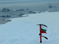
- L. L. Ivanov et al. Antarctica: Livingston Island and Greenwich Island, South Shetland Islands (from English Strait to Morton Strait, with illustrations and ice-cover distribution). Scale 1:100000 topographic map. Antarctic Place-names CommissionAntarctic Place-names CommissionThe Antarctic Place-names Commission was established by the Bulgarian Antarctic Institute in 1994, and since 2001 has been a body affiliated to the Ministry of Foreign Affairs of Bulgaria. The Commission approves Bulgarian place names in Antarctica, which are formally given by the President of the...
of BulgariaBulgariaBulgaria , officially the Republic of Bulgaria , is a parliamentary democracy within a unitary constitutional republic in Southeast Europe. The country borders Romania to the north, Serbia and Macedonia to the west, Greece and Turkey to the south, as well as the Black Sea to the east...
, SofiaSofiaSofia is the capital and largest city of Bulgaria and the 12th largest city in the European Union with a population of 1.27 million people. It is located in western Bulgaria, at the foot of Mount Vitosha and approximately at the centre of the Balkan Peninsula.Prehistoric settlements were excavated...
, 2005. - L. L. Ivanov. Antarctica: Livingston Island and Greenwich, Robert, Snow and Smith Islands. Scale 1:120000 topographic map. Troyan: Manfred Wörner Foundation, 2009. ISBN 978-954-92032-6-4.
External links
- Commonwealth Secretariat Website describing BAT
- Foreign and Commonwealth Office - profile of BAT
- Argentine Government Website with a map of the South Shetland Islands
- Argentine Government website about the history of Antarctica