

Graham Land
Encyclopedia
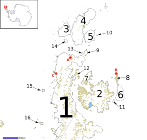
Antarctic Peninsula
The Antarctic Peninsula is the northernmost part of the mainland of Antarctica. It extends from a line between Cape Adams and a point on the mainland south of Eklund Islands....
which lies north of a line joining Cape Jeremy
Cape Jeremy
Cape Jeremy is a cape marking the east side of the north entrance to George VI Sound and the west end of a line dividing Graham Land and Palmer Land. It was discovered by the British Graham Land Expedition , 1934–37, under Rymill, who named it for Jeremy Scott, son of J.M. Scott, who served as...
and Cape Agassiz
Cape Agassiz
Cape Agassiz is the east tip of Hollick-Kenyon Peninsula, a narrow ice-drowned spur extending east from the main mountain axis of Antarctic Peninsula between Mobiloil Inlet and Revelle Inlet. The cape is the east end of a line from Cape Jeremy dividing Graham Land and Palmer Land. It was...
. This description of Graham Land is consistent with the 1964 agreement between the British
United Kingdom
The United Kingdom of Great Britain and Northern IrelandIn the United Kingdom and Dependencies, other languages have been officially recognised as legitimate autochthonous languages under the European Charter for Regional or Minority Languages...
Antarctic Place-names Committee and the US
United States
The United States of America is a federal constitutional republic comprising fifty states and a federal district...
Advisory Committee on Antarctic Names
Advisory Committee on Antarctic Names
The Advisory Committee on Antarctic Names is an advisory committee of the United States Board on Geographic Names responsible for recommending names for features in Antarctica...
, in which the name "Antarctic Peninsula" was approved for the major peninsula of Antarctica, and the names Graham Land and Palmer Land
Palmer Land
Palmer Land is that portion of the Antarctic Peninsula which lies south of a line joining Cape Jeremy and Cape Agassiz. This application of Palmer Land is consistent with the 1964 agreement between US-ACAN and UK-APC, in which the name Antarctic Peninsula was approved for the major peninsula of...
for the northern and southern portions, respectively.
Graham Land is named after Sir James R. G. Graham, First Lord of the Admiralty at the time of John Biscoe
John Biscoe
John Biscoe was an English mariner and explorer who commanded the first expedition known to have sighted the areas named Enderby Land and Graham Land along the coast of Antarctica...
's exploration of the west side of Graham Land in 1832. It is claimed by Britain (as part of the British Antarctic Territory
British Antarctic Territory
The British Antarctic Territory is a sector of Antarctica claimed by the United Kingdom as one of its 14 British Overseas Territories. It comprises the region south of 60°S latitude and between longitudes and , forming a wedge shape that extends to the South Pole...
), Argentina (as part of Argentine Antarctica), and Chile (as part of the Chilean Antarctic Territory).
Graham Land is the closest part of Antarctica to South America.