

Ross Sea
Encyclopedia
Headlands and bays
Headlands and bays are two related features of the coastal environment.- Geology and geography :Headlands and bays are often found on the same coastline. A bay is surrounded by land on three sides, whereas a headland is surrounded by water on three sides. Headlands are characterized by high,...
of the Southern Ocean
Southern Ocean
The Southern Ocean comprises the southernmost waters of the World Ocean, generally taken to be south of 60°S latitude and encircling Antarctica. It is usually regarded as the fourth-largest of the five principal oceanic divisions...
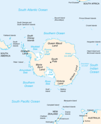
in Antarctica between Victoria Land
Victoria Land
Victoria Land is a region of Antarctica bounded on the east by the Ross Ice Shelf and the Ross Sea and on the west by Oates Land and Wilkes Land. It was discovered by Captain James Clark Ross in January 1841 and named after the UK's Queen Victoria...
and Marie Byrd Land
Marie Byrd Land
Marie Byrd Land is the portion of West Antarctica lying east of the Ross Ice Shelf and the Ross Sea and south of the Pacific Ocean, extending eastward approximately to a line between the head of the Ross Ice Shelf and Eights Coast. It stretches between 158°W and 103°24'W...
.
Description
The Ross Sea was discovered by James RossJames Clark Ross
Sir James Clark Ross , was a British naval officer and explorer. He explored the Arctic with his uncle Sir John Ross and Sir William Parry, and later led his own expedition to Antarctica.-Arctic explorer:...
in 1841. In the west of the Ross Sea is Ross Island
Ross Island
Ross Island is an island formed by four volcanoes in the Ross Sea near the continent of Antarctica, off the coast of Victoria Land in McMurdo Sound.-Geography:...
with the Mt. Erebus
Mount Erebus
Mount Erebus in Antarctica is the southernmost historically active volcano on Earth, the second highest volcano in Antarctica , and the 6th highest ultra mountain on an island. With a summit elevation of , it is located on Ross Island, which is also home to three inactive volcanoes, notably Mount...
volcano
Volcano
2. Bedrock3. Conduit 4. Base5. Sill6. Dike7. Layers of ash emitted by the volcano8. Flank| 9. Layers of lava emitted by the volcano10. Throat11. Parasitic cone12. Lava flow13. Vent14. Crater15...
, in the east Roosevelt Island
Roosevelt Island, Antarctica
Roosevelt Island is an ice-covered island, about long in a NW-SE direction, wide and about in area, lying in the eastern part of the Ross Ice Shelf of Antarctica...
. The southern part is covered by the Ross Ice Shelf
Ross Ice Shelf
The Ross Ice Shelf is the largest ice shelf of Antarctica . It is several hundred metres thick. The nearly vertical ice front to the open sea is more than 600 km long, and between 15 and 50 metres high above the water surface...
. Roald Amundsen
Roald Amundsen
Roald Engelbregt Gravning Amundsen was a Norwegian explorer of polar regions. He led the first Antarctic expedition to reach the South Pole between 1910 and 1912 and he was the first person to reach both the North and South Poles. He is also known as the first to traverse the Northwest Passage....
started his South Pole
South Pole
The South Pole, also known as the Geographic South Pole or Terrestrial South Pole, is one of the two points where the Earth's axis of rotation intersects its surface. It is the southernmost point on the surface of the Earth and lies on the opposite side of the Earth from the North Pole...
expedition in 1911 from the Bay of Whales
Bay of Whales
The Bay of Whales is a natural ice harbor, or iceport, indenting the front of Ross Ice Shelf just north of Roosevelt Island. It is the southernmost point of open ocean not only of the Ross Sea, but worldwide...
, which was located at the shelf. In the west of the Ross sea, McMurdo Sound
McMurdo Sound
The ice-clogged waters of Antarctica's McMurdo Sound extend about 55 km long and wide. The sound opens into the Ross Sea to the north. The Royal Society Range rises from sea level to 13,205 feet on the western shoreline. The nearby McMurdo Ice Shelf scribes McMurdo Sound's southern boundary...
is a port which is usually free of ice during the summer. The southernmost part of the Ross Sea is Gould Coast
Gould Coast
The Gould Coast is that portion of the coast along the east margin of the Ross Ice Shelf between the west side of Scott Glacier and the south end of Siple Coast . Named by NZ-APC in 1961 for Laurence M. Gould, a geologist who was second-in-command of the Byrd Antarctic Expedition, 1928-30. Gould...
, which is approximately two hundred miles from the Geographic South Pole.
All land masses in the Ross Sea are claimed by New Zealand
New Zealand
New Zealand is an island country in the south-western Pacific Ocean comprising two main landmasses and numerous smaller islands. The country is situated some east of Australia across the Tasman Sea, and roughly south of the Pacific island nations of New Caledonia, Fiji, and Tonga...
to fall under the jurisdiction
Jurisdiction
Jurisdiction is the practical authority granted to a formally constituted legal body or to a political leader to deal with and make pronouncements on legal matters and, by implication, to administer justice within a defined area of responsibility...
of the Ross Dependency
Ross Dependency
The Ross Dependency is a region of Antarctica defined by a sector originating at the South Pole, passing along longitudes 160° east to 150° west, and terminating at latitude 60° south...
, but few non-Commonwealth nations recognise this claim.
A 10 metre (32.8 feet) long colossal squid
Colossal Squid
The colossal squid , sometimes called the Antarctic or giant cranch squid, is believed to be the largest squid species in terms of mass. It is the only known member of the genus Mesonychoteuthis...
weighing 495 kilograms (1,091 lb) was captured in the Ross Sea on February 22, 2007.
Ecological importance and conservation
Flora and fauna are just like the southern Antarctic marine regions. The nutrient-rich sea water supports abundant planktonic lifePlankton
Plankton are any drifting organisms that inhabit the pelagic zone of oceans, seas, or bodies of fresh water. That is, plankton are defined by their ecological niche rather than phylogenetic or taxonomic classification...
which in turn provides food for larger species, such as fish
Fish
Fish are a paraphyletic group of organisms that consist of all gill-bearing aquatic vertebrate animals that lack limbs with digits. Included in this definition are the living hagfish, lampreys, and cartilaginous and bony fish, as well as various extinct related groups...
, seal
Pinniped
Pinnipeds or fin-footed mammals are a widely distributed and diverse group of semiaquatic marine mammals comprising the families Odobenidae , Otariidae , and Phocidae .-Overview: Pinnipeds are typically sleek-bodied and barrel-shaped...
s, whale
Whale
Whale is the common name for various marine mammals of the order Cetacea. The term whale sometimes refers to all cetaceans, but more often it excludes dolphins and porpoises, which belong to suborder Odontoceti . This suborder also includes the sperm whale, killer whale, pilot whale, and beluga...
s, and sea- and shore-bird
Bird
Birds are feathered, winged, bipedal, endothermic , egg-laying, vertebrate animals. Around 10,000 living species and 188 families makes them the most speciose class of tetrapod vertebrates. They inhabit ecosystems across the globe, from the Arctic to the Antarctic. Extant birds range in size from...
s. Among the latter, rookeries of Adélie
Adelie Penguin
The Adélie Penguin, Pygoscelis adeliae, is a species of penguin common along the entire Antarctic coast. They are among the most southerly distributed of all seabirds, as are the Emperor Penguin, the South Polar Skua, the Wilson's Storm Petrel, the Snow Petrel, and the Antarctic Petrel...
and Emperor can be seen at a number of places around the Ross Sea. The Ross Sea is one of the last stretches of sea
Sea
A sea generally refers to a large body of salt water, but the term is used in other contexts as well. Most commonly, it means a large expanse of saline water connected with an ocean, and is commonly used as a synonym for ocean...
s on Earth
Earth
Earth is the third planet from the Sun, and the densest and fifth-largest of the eight planets in the Solar System. It is also the largest of the Solar System's four terrestrial planets...
that has not been harmed by human activities. But still it is yet to be damaged extensively by pollution
Pollution
Pollution is the introduction of contaminants into a natural environment that causes instability, disorder, harm or discomfort to the ecosystem i.e. physical systems or living organisms. Pollution can take the form of chemical substances or energy, such as noise, heat or light...
, overfishing
Overfishing
Overfishing occurs when fishing activities reduce fish stocks below an acceptable level. This can occur in any body of water from a pond to the oceans....
and introducing invasive species
Invasive species
"Invasive species", or invasive exotics, is a nomenclature term and categorization phrase used for flora and fauna, and for specific restoration-preservation processes in native habitats, with several definitions....
. The world now has a rare opportunity to protect the Ross Sea from a growing number of threats and destruction. The Ross Sea has incredible biological diversity and a long history of human exploration and scientific research.
See also
- Beaufort IslandBeaufort IslandBeaufort Island is an island in Antarctica's Ross Sea. It is the northernmost feature of the Ross Archipelago, lying north of Cape Bird, Ross Island. It is approximately in area. It was first charted by James Clark Ross in 1841...
- Iceberg B-15Iceberg B-15Iceberg B-15 is one of the world's largest recorded icebergs. It measured around 295 km long and 37 km wide , with a surface area of 11,000 km² larger than the island of Jamaica. The mass was estimated around three billion tonnes...
- McMurdo SoundMcMurdo SoundThe ice-clogged waters of Antarctica's McMurdo Sound extend about 55 km long and wide. The sound opens into the Ross Sea to the north. The Royal Society Range rises from sea level to 13,205 feet on the western shoreline. The nearby McMurdo Ice Shelf scribes McMurdo Sound's southern boundary...
- Ross DependencyRoss DependencyThe Ross Dependency is a region of Antarctica defined by a sector originating at the South Pole, passing along longitudes 160° east to 150° west, and terminating at latitude 60° south...
- Ross GyreRoss GyreThe Ross Gyre is one of the two gyres that exist within the Southern Ocean. The gyre is located in the Ross Sea, and rotates clockwise. The gyre is formed by interactions between the Antarctic Circumpolar Current and the Antarctic Continental Shelf...
- Ross Ice ShelfRoss Ice ShelfThe Ross Ice Shelf is the largest ice shelf of Antarctica . It is several hundred metres thick. The nearly vertical ice front to the open sea is more than 600 km long, and between 15 and 50 metres high above the water surface...
- Ross IslandRoss IslandRoss Island is an island formed by four volcanoes in the Ross Sea near the continent of Antarctica, off the coast of Victoria Land in McMurdo Sound.-Geography:...
External links
- J.Glausiusz, 2007, Raw Data: Beacon Bird of Climate Change. Discover Magazine.
- Gunn, B., nd, Geology The Ross Sea Dependency including Victoria-Land Ross Sea, Antarctica, Including the Ross Sea Dependency, the Sub-Antarctic Islands and sea, up to New Zealand from the Pole.
- K.Hansen, 2007, Paleoclimate: Penguin poop adds to climate picture. Geotimes.
- International Polar Foundation, 2007, Interview with Dr. Steven Emslie: The Adélie Penguins' Diet Shift. SciencePoles website.
- C.Michael Hogan. 2011. Ross Sea. Eds. P.Saundry & C.J.Cleveland. Encyclopedia of Earth. National Council for Science and the Environment. Washington DC
- Locarnini, R.A., 1995, the Ross Sea. Quarterdeck, vol. 1, no. 3.(Department of Oceanography, Texas A&M UniversityTexas A&M UniversityTexas A&M University is a coeducational public research university located in College Station, Texas . It is the flagship institution of the Texas A&M University System. The sixth-largest university in the United States, A&M's enrollment for Fall 2011 was over 50,000 for the first time in school...
, College Station, Texas.)