

Extremes on Earth
Encyclopedia
This article describes extreme locations on Earth
. Entries listed in bold are Earth-wide extremes.
| rowspan="2" style="vertical-align:bottom;" | Continent
| colspan="3" | Elevation
(height above
/below sea level
)
| colspan="2" | Temperature
(recorded)
|-
| colspan="2" | Highest
| Lowest
| Highest
| Lowest
|-
| Africa
|| style="text-align:left;" | 5893 m (19,334 ft)
Kilimanjaro
, Tanzania
|| style="text-align:left;" |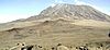 || style="text-align:left;" | −155 m
Lake Assal, Djibouti
|| style="text-align:left;" | 57.8 °C (136 °F)
'Aziziya, Libya
13 September 1922.
(Disputed) || style="text-align:left;" | -23.9 C
Ifrane
, Morocco
11 February 1935
|-
| Antarctica || style="text-align:left;" | 4892 m (16,050 ft)
Vinson Massif
|| style="text-align:left;" | || style="text-align:left;" | -50 m
Deep Lake, Vestfold Hills
(compare the deepest ice section below) || style="text-align:left;" | 15 °C (59 °F)
Vanda Station
5 January 1974 || style="text-align:left;" | −89.2 C
Vostok Station
21 July 1983
|-
| rowspan="2" style="vertical-align:center;" | Asia
|| rowspan="2" style="vertical-align:center; text-align:left;" | 8850 m (29,035 ft)
Mount Everest
, Nepal
/ China
|| rowspan="2" style="vertical-align:center; text-align:left;" |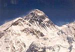 || rowspan="2" style="vertical-align:center; text-align:left;" | −424 m
Dead Sea
shore, Israel
- Jordan
|| rowspan="2" style="vertical-align:center; text-align:left;" | 55 °C (131 °F)
Mitraba
, Kuwait
15 June 2010 || style="text-align:left;" | −67.8 C Measured
Verkhoyansk
, Siberia
, Russia
(then in the Russian Empire
)
5 February 1892
|-
| style="text-align:left;" | −71.2 C Extrapolated
Oymyakon
, Siberia
, Russia
(then in the Soviet Union
)
26 January 1926
|-
| Europe
|| style="text-align:left;" | 5642 m (18,510 ft)
Mount Elbrus
, Russia
(compare the Mont Blanc
) || style="text-align:left;" |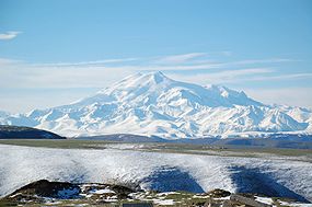 || style="text-align:left;" | −28 m
Caspian Sea
shore, Russia
(compare the Tagebau Hambach
) || style="text-align:left;" | 48 °C (118.4 °F)
Athens
, Greece
(and Elefsina, Greece
)
10 July 1977 || style="text-align:left;" | −58.1 C
Ust-Shchuger, Russia
31 December 1978
|-
| rowspan="2" style="vertical-align:center;" | North America
|| rowspan="2" style="vertical-align:center; text-align:left;" | 6198 m (20,335 ft)
Denali (Mount McKinley), Alaska
, U.S.A.
|| rowspan="2" style="vertical-align:center; text-align:left;" |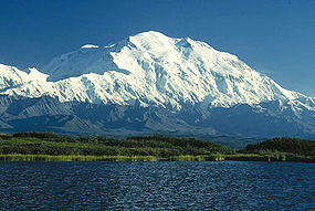 || rowspan="2" style="vertical-align:center; text-align:left;" | −86 m
Death Valley
, California
, U.S.A.
(compare the deepest ice section below) || rowspan="2" style="vertical-align:center; text-align:left;" | 56.7 °C (134.1 °F)
Death Valley
, California
, U.S.A.
10 July 1913 || style="text-align:left;" | −63.0 C
Snag
, Yukon
, Canada
3 February 1947
|-
| style="text-align:left;" | −66.1 C
North Ice
, Greenland
9 January 1954
|-
| Oceania
(Australia
) || style="text-align:left;" | 4884 m (16,024 ft)
Puncak Jaya
(Carstensz Pyramid), Indonesia
(compare the Mount Wilhelm
and Mount Kosciuszko
) || style="text-align:left;" | || style="text-align:left;" | −15 m
Lake Eyre
, South Australia
, Australia
|| style="text-align:left;" | 50.7 °C (123.3 °F)
Oodnadatta
, South Australia
, Australia
2 January 1960 || style="text-align:left;" | −25.6 C
Ranfurly
, New Zealand
18 July 1903
|-
| South America
|| style="text-align:left;" | 6962 m (22,841 ft)
Aconcagua
, Mendoza
, Argentina
|| style="text-align:left;" |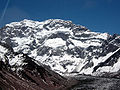 || style="text-align:left;" | −105 m
Laguna del Carbón
, Argentina
|| style="text-align:left;" | 48.9 °C (120 °F)
Rivadavia
, Salta Province
, Argentina
11 December 1905 || style="text-align:left;" | −32.8 C
Sarmiento
, Argentina
1 June 1907
|-
| colspan="6" style="text-align:left;" |
| Greatest purely vertical drop || 1250 m (4,101 ft)
Mount Thor
, Auyuittuq National Park
, Baffin Island
, Nunavut
, Canada
(summit elevation 1675 m (5,495 ft))
|-
| Greatest nearly vertical drop ||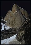 1340 m (4,396 ft)
Trango Towers
, Pakistan
(summit elevation 6286 m (20,623 ft))
|-
|}
| Deepest mine
|| 4000 m (13,123 ft)
Mponeng Gold mine
, South Africa
|-
| Deepest mine under sea level|| 2733 m (8,967 ft) under sea level
Kidd Mine, Ontario
, Canada
|-
| Deepest open-pit mine|| 1200 m (3,937 ft)
Bingham Canyon Mine
, Utah
, USA
|-
| Deepest open-pit mine under sea level|| 293 m (961 ft) under sea level
Tagebau Hambach
, Germany
|-
| Deepest cave
|| 2193 m (7,195 ft)
Voronya Cave
, Arabika Massif, Georgia
|-
| Deepest pitch
(single vertical drop) || 603 m (1,978 ft)
Vrtoglavica Cave
, Slovenia
|-
|}
| Atlantic Ocean
|| 8648 m (28,373 ft)
Milwaukee Deep
, Puerto Rico Trench
|-
| Arctic Ocean
|| 5450 m (17,881 ft)
Litke Deep
, Eurasian Basin
|-
| Indian Ocean
|| 7258 m (23,812 ft)
Java Trench
|-
| Pacific Ocean
|| 10971 m (35,994 ft)
Challenger Deep
, Mariana Trench
|-
| Southern Ocean
|| 7235 m (23,737 ft)
South Sandwich Trench
(southernmost portion, at 60°S)
|-
|}
{| class="wikitable"
|Bentley Subglacial Trench
|| −2555 m || Antarctica
|-
|Trough beneath Jakobshavn Isbræ
|| -1512 m|| Greenland
|-
|}
| Hottest inhabited place || Dallol, Ethiopia
, whose annual mean temperature was recorded from 1960 to 1966 as 34.4 °C (93.9 °F). The average daily maximum temperature during the same period was 41.1 °C (106 °F).
|-
| rowspan=2|Coldest inhabited place || Oymyakon
(Russian: Оймякон), a village (selo) in Oymyakonsky Ulus of the Sakha Republic, Russia, located along the Indigirka River. It has -16 C as yearly average and -46 C as daily average in January, the coldest month.
|-
|The South Pole
and some other places in Antarctica are colder and are populated year-round, but almost everyone stays less than a year and could be considered visitors, not inhabitants.
|}
| Northernmost point on land || Kaffeklubben Island
, east of Greenland
(83°40′N 29°50′W)
Various shifting gravel bars lie further north, the most famous being Oodaaq
|-
| Southernmost point on land || The geographic South Pole
|-
|}
Earth
Earth is the third planet from the Sun, and the densest and fifth-largest of the eight planets in the Solar System. It is also the largest of the Solar System's four terrestrial planets...
. Entries listed in bold are Earth-wide extremes.
Extreme elevations and temperatures per continent
{| class="wikitable" border="1" style="text-align:center;"| rowspan="2" style="vertical-align:bottom;" | Continent
| colspan="3" | Elevation
Elevation
The elevation of a geographic location is its height above a fixed reference point, most commonly a reference geoid, a mathematical model of the Earth's sea level as an equipotential gravitational surface ....
(height above
Above mean sea level
The term above mean sea level refers to the elevation or altitude of any object, relative to the average sea level datum. AMSL is used extensively in radio by engineers to determine the coverage area a station will be able to reach...
/below sea level
Sea level
Mean sea level is a measure of the average height of the ocean's surface ; used as a standard in reckoning land elevation...
)
| colspan="2" | Temperature
Temperature
Temperature is a physical property of matter that quantitatively expresses the common notions of hot and cold. Objects of low temperature are cold, while various degrees of higher temperatures are referred to as warm or hot...
(recorded)
|-
| colspan="2" | Highest
| Lowest
| Highest
| Lowest
|-
| Africa
Africa
Africa is the world's second largest and second most populous continent, after Asia. At about 30.2 million km² including adjacent islands, it covers 6% of the Earth's total surface area and 20.4% of the total land area...
|| style="text-align:left;" | 5893 m (19,334 ft)
Kilimanjaro
Mount Kilimanjaro
Kilimanjaro, with its three volcanic cones, Kibo, Mawenzi, and Shira, is a dormant volcano in Kilimanjaro National Park, Tanzania and the highest mountain in Africa at above sea level .-Geology:...
, Tanzania
Tanzania
The United Republic of Tanzania is a country in East Africa bordered by Kenya and Uganda to the north, Rwanda, Burundi, and the Democratic Republic of the Congo to the west, and Zambia, Malawi, and Mozambique to the south. The country's eastern borders lie on the Indian Ocean.Tanzania is a state...
|| style="text-align:left;" |
Lake Assal, Djibouti
Djibouti
Djibouti , officially the Republic of Djibouti , is a country in the Horn of Africa. It is bordered by Eritrea in the north, Ethiopia in the west and south, and Somalia in the southeast. The remainder of the border is formed by the Red Sea and the Gulf of Aden at the east...
|| style="text-align:left;" | 57.8 °C (136 °F)
'Aziziya, Libya
Libya
Libya is an African country in the Maghreb region of North Africa bordered by the Mediterranean Sea to the north, Egypt to the east, Sudan to the southeast, Chad and Niger to the south, and Algeria and Tunisia to the west....
13 September 1922.
(Disputed) || style="text-align:left;" | -23.9 C
Ifrane
Ifrane
Ifrane [p] is a town and ski resort in the Middle Atlas region of Morocco .Ifrane is 1665 metres in altitude and is part of the Meknès-Tafilalet region...
, Morocco
Morocco
Morocco , officially the Kingdom of Morocco , is a country located in North Africa. It has a population of more than 32 million and an area of 710,850 km², and also primarily administers the disputed region of the Western Sahara...
11 February 1935
|-
| Antarctica || style="text-align:left;" | 4892 m (16,050 ft)
Vinson Massif
Vinson Massif
Vinson Massif is the highest mountain of Antarctica, lying in the Sentinel Range of the Ellsworth Mountains, which stand above the Ronne Ice Shelf near the base of the Antarctic Peninsula. The massif is located about from the South Pole and is about long and wide. At the highest point is Mount...
|| style="text-align:left;" |
Deep Lake, Vestfold Hills
Vestfold Hills
Vestfold Hills is an area of rounded rock coastal hills, in extent, located at the north side of Sorsdal Glacier on Ingrid Christensen Coast in Antarctica. The hills are subdivided by three west-trending peninsulas bounded by narrow fjords...
(compare the deepest ice section below) || style="text-align:left;" | 15 °C (59 °F)
Vanda Station
Vanda Station
Vanda Station was an Antarctic research base in the western highlands of the Ross Dependency, specifically on the shore of Lake Vanda, at the mouth of Onyx River, in the Wright Valley...
5 January 1974 || style="text-align:left;" | −89.2 C
Vostok Station
Vostok Station
Vostok Station was a Russian Antarctic research station. It was at the southern Pole of Cold, with the lowest reliably measured natural temperature on Earth of −89.2 °C . Research includes ice core drilling and magnetometry...
21 July 1983
|-
| rowspan="2" style="vertical-align:center;" | Asia
Asia
Asia is the world's largest and most populous continent, located primarily in the eastern and northern hemispheres. It covers 8.7% of the Earth's total surface area and with approximately 3.879 billion people, it hosts 60% of the world's current human population...
|| rowspan="2" style="vertical-align:center; text-align:left;" | 8850 m (29,035 ft)
Mount Everest
Mount Everest
Mount Everest is the world's highest mountain, with a peak at above sea level. It is located in the Mahalangur section of the Himalayas. The international boundary runs across the precise summit point...
, Nepal
Nepal
Nepal , officially the Federal Democratic Republic of Nepal, is a landlocked sovereign state located in South Asia. It is located in the Himalayas and bordered to the north by the People's Republic of China, and to the south, east, and west by the Republic of India...
/ China
China
Chinese civilization may refer to:* China for more general discussion of the country.* Chinese culture* Greater China, the transnational community of ethnic Chinese.* History of China* Sinosphere, the area historically affected by Chinese culture...
|| rowspan="2" style="vertical-align:center; text-align:left;" |
Dead Sea
Dead Sea
The Dead Sea , also called the Salt Sea, is a salt lake bordering Jordan to the east and Israel and the West Bank to the west. Its surface and shores are below sea level, the lowest elevation on the Earth's surface. The Dead Sea is deep, the deepest hypersaline lake in the world...
shore, Israel
Israel
The State of Israel is a parliamentary republic located in the Middle East, along the eastern shore of the Mediterranean Sea...
- Jordan
Jordan
Jordan , officially the Hashemite Kingdom of Jordan , Al-Mamlaka al-Urduniyya al-Hashemiyya) is a kingdom on the East Bank of the River Jordan. The country borders Saudi Arabia to the east and south-east, Iraq to the north-east, Syria to the north and the West Bank and Israel to the west, sharing...
|| rowspan="2" style="vertical-align:center; text-align:left;" | 55 °C (131 °F)
Mitraba
Mitraba
Mitraba is a barren land in the northern Kuwait region, it currently holds the record of highest temperature ever recorded in Asia on 15 June 2010 when the mercury rose up to 55°C...
, Kuwait
Kuwait
The State of Kuwait is a sovereign Arab state situated in the north-east of the Arabian Peninsula in Western Asia. It is bordered by Saudi Arabia to the south at Khafji, and Iraq to the north at Basra. It lies on the north-western shore of the Persian Gulf. The name Kuwait is derived from the...
15 June 2010 || style="text-align:left;" | −67.8 C Measured
Verkhoyansk
Verkhoyansk
Verkhoyansk is a town in Verkhoyansky District of the Sakha Republic, Russia, situated on the Yana River, near the Arctic Circle, from Yakutsk. Population: There is a river port, an airport, a fur-collecting depot, and the center of a reindeer-raising area....
, Siberia
Siberia
Siberia is an extensive region constituting almost all of Northern Asia. Comprising the central and eastern portion of the Russian Federation, it was part of the Soviet Union from its beginning, as its predecessor states, the Tsardom of Russia and the Russian Empire, conquered it during the 16th...
, Russia
Russia
Russia or , officially known as both Russia and the Russian Federation , is a country in northern Eurasia. It is a federal semi-presidential republic, comprising 83 federal subjects...
(then in the Russian Empire
Russian Empire
The Russian Empire was a state that existed from 1721 until the Russian Revolution of 1917. It was the successor to the Tsardom of Russia and the predecessor of the Soviet Union...
)
5 February 1892
|-
| style="text-align:left;" | −71.2 C Extrapolated
Oymyakon
Oymyakon
Oymyakon is a village in Oymyakonsky Ulus of the Sakha Republic, Russia, located along the Indigirka River, 30 kilometres northwest of Tomtor on the Kolyma Highway.-Geography:...
, Siberia
Siberia
Siberia is an extensive region constituting almost all of Northern Asia. Comprising the central and eastern portion of the Russian Federation, it was part of the Soviet Union from its beginning, as its predecessor states, the Tsardom of Russia and the Russian Empire, conquered it during the 16th...
, Russia
Russia
Russia or , officially known as both Russia and the Russian Federation , is a country in northern Eurasia. It is a federal semi-presidential republic, comprising 83 federal subjects...
(then in the Soviet Union
Soviet Union
The Soviet Union , officially the Union of Soviet Socialist Republics , was a constitutionally socialist state that existed in Eurasia between 1922 and 1991....
)
26 January 1926
|-
| Europe
Europe
Europe is, by convention, one of the world's seven continents. Comprising the westernmost peninsula of Eurasia, Europe is generally 'divided' from Asia to its east by the watershed divides of the Ural and Caucasus Mountains, the Ural River, the Caspian and Black Seas, and the waterways connecting...
|| style="text-align:left;" | 5642 m (18,510 ft)
Mount Elbrus
Mount Elbrus
Mount Elbrus is an inactive volcano located in the western Caucasus mountain range, in Kabardino-Balkaria and Karachay-Cherkessia, Russia, near the border of Georgia. Mt. Elbrus's peak is the highest in the Caucasus, in Russia...
, Russia
Russia
Russia or , officially known as both Russia and the Russian Federation , is a country in northern Eurasia. It is a federal semi-presidential republic, comprising 83 federal subjects...
(compare the Mont Blanc
Mont Blanc
Mont Blanc or Monte Bianco , meaning "White Mountain", is the highest mountain in the Alps, Western Europe and the European Union. It rises above sea level and is ranked 11th in the world in topographic prominence...
) || style="text-align:left;" |
Caspian Sea
Caspian Sea
The Caspian Sea is the largest enclosed body of water on Earth by area, variously classed as the world's largest lake or a full-fledged sea. The sea has a surface area of and a volume of...
shore, Russia
Russia
Russia or , officially known as both Russia and the Russian Federation , is a country in northern Eurasia. It is a federal semi-presidential republic, comprising 83 federal subjects...
(compare the Tagebau Hambach
Tagebau Hambach
The Tagebau Hambach is a large strip mine in Niederzier and Elsdorf, North-Rhine Westphalia, Germany. It is operated by RWE and used for mining lignite. Begun in 1978, the mine currently has a size of 33.89 km² and is planned to eventually have a size of 85 km². It is the deepest open pit mine...
) || style="text-align:left;" | 48 °C (118.4 °F)
Athens
Athens
Athens , is the capital and largest city of Greece. Athens dominates the Attica region and is one of the world's oldest cities, as its recorded history spans around 3,400 years. Classical Athens was a powerful city-state...
, Greece
Greece
Greece , officially the Hellenic Republic , and historically Hellas or the Republic of Greece in English, is a country in southeastern Europe....
(and Elefsina, Greece
Greece
Greece , officially the Hellenic Republic , and historically Hellas or the Republic of Greece in English, is a country in southeastern Europe....
)
10 July 1977 || style="text-align:left;" | −58.1 C
Ust-Shchuger, Russia
Russia
Russia or , officially known as both Russia and the Russian Federation , is a country in northern Eurasia. It is a federal semi-presidential republic, comprising 83 federal subjects...
31 December 1978
|-
| rowspan="2" style="vertical-align:center;" | North America
North America
North America is a continent wholly within the Northern Hemisphere and almost wholly within the Western Hemisphere. It is also considered a northern subcontinent of the Americas...
|| rowspan="2" style="vertical-align:center; text-align:left;" | 6198 m (20,335 ft)
Denali (Mount McKinley), Alaska
Alaska
Alaska is the largest state in the United States by area. It is situated in the northwest extremity of the North American continent, with Canada to the east, the Arctic Ocean to the north, and the Pacific Ocean to the west and south, with Russia further west across the Bering Strait...
, U.S.A.
United States
The United States of America is a federal constitutional republic comprising fifty states and a federal district...
|| rowspan="2" style="vertical-align:center; text-align:left;" |
Death Valley
Death Valley
Death Valley is a desert valley located in Eastern California. Situated within the Mojave Desert, it features the lowest, driest, and hottest locations in North America. Badwater, a basin located in Death Valley, is the specific location of the lowest elevation in North America at 282 feet below...
, California
California
California is a state located on the West Coast of the United States. It is by far the most populous U.S. state, and the third-largest by land area...
, U.S.A.
United States
The United States of America is a federal constitutional republic comprising fifty states and a federal district...
(compare the deepest ice section below) || rowspan="2" style="vertical-align:center; text-align:left;" | 56.7 °C (134.1 °F)
Death Valley
Death Valley
Death Valley is a desert valley located in Eastern California. Situated within the Mojave Desert, it features the lowest, driest, and hottest locations in North America. Badwater, a basin located in Death Valley, is the specific location of the lowest elevation in North America at 282 feet below...
, California
California
California is a state located on the West Coast of the United States. It is by far the most populous U.S. state, and the third-largest by land area...
, U.S.A.
United States
The United States of America is a federal constitutional republic comprising fifty states and a federal district...
10 July 1913 || style="text-align:left;" | −63.0 C
Snag
Snag, Yukon
Snag is a village located on a small, dry-weather sideroad off the Alaska Highway south of Beaver Creek, Yukon, Canada. The village of Snag is located in a bowl-shaped valley of the White River and its tributaries, including Snag Creek. It was first settled during the Klondike Gold Rush. An...
, Yukon
Yukon
Yukon is the westernmost and smallest of Canada's three federal territories. It was named after the Yukon River. The word Yukon means "Great River" in Gwich’in....
, Canada
Canada
Canada is a North American country consisting of ten provinces and three territories. Located in the northern part of the continent, it extends from the Atlantic Ocean in the east to the Pacific Ocean in the west, and northward into the Arctic Ocean...
3 February 1947
|-
| style="text-align:left;" | −66.1 C
North Ice
North Ice
North Ice was the name of a research station of the British North Greenland Expedition on the inland ice of Greenland. The coordinates of the station were , with an altitude of 2,345 metres above sea level...
, Greenland
Greenland
Greenland is an autonomous country within the Kingdom of Denmark, located between the Arctic and Atlantic Oceans, east of the Canadian Arctic Archipelago. Though physiographically a part of the continent of North America, Greenland has been politically and culturally associated with Europe for...
9 January 1954
|-
| Oceania
Oceania
Oceania is a region centered on the islands of the tropical Pacific Ocean. Conceptions of what constitutes Oceania range from the coral atolls and volcanic islands of the South Pacific to the entire insular region between Asia and the Americas, including Australasia and the Malay Archipelago...
(Australia
Australia (continent)
Australia is the world's smallest continent, comprising the mainland of Australia and proximate islands including Tasmania, New Guinea, the Aru Islands and Raja Ampat Islands...
) || style="text-align:left;" | 4884 m (16,024 ft)
Puncak Jaya
Puncak Jaya
Puncak Jaya or Carstensz Pyramid is the highest summit of Mount Carstensz in the Sudirman Range of the western central highlands of Papua province, Indonesia . Other summits are East Carstensz Peak and Ngga Pulu...
(Carstensz Pyramid), Indonesia
Indonesia
Indonesia , officially the Republic of Indonesia , is a country in Southeast Asia and Oceania. Indonesia is an archipelago comprising approximately 13,000 islands. It has 33 provinces with over 238 million people, and is the world's fourth most populous country. Indonesia is a republic, with an...
(compare the Mount Wilhelm
Mount Wilhelm
Mount Wilhelm is the highest mountain in Papua New Guinea at . It is part of the Bismarck Range and the peak is the point where three provinces intersect, Simbu, Western Highlands and Madang...
and Mount Kosciuszko
Mount Kosciuszko
Mount Kosciuszko is a mountain located in the Snowy Mountains in Kosciuszko National Park. With a height of 2,228 metres above sea level, it is the highest mountain in Australia...
) || style="text-align:left;" |
Lake Eyre
Lake Eyre
Lake Eyre is the lowest point in Australia, at approximately below sea level, and, on the rare occasions that it fills, it is the largest lake in Australia and 18th largest in the world...
, South Australia
South Australia
South Australia is a state of Australia in the southern central part of the country. It covers some of the most arid parts of the continent; with a total land area of , it is the fourth largest of Australia's six states and two territories.South Australia shares borders with all of the mainland...
, Australia
Australia
Australia , officially the Commonwealth of Australia, is a country in the Southern Hemisphere comprising the mainland of the Australian continent, the island of Tasmania, and numerous smaller islands in the Indian and Pacific Oceans. It is the world's sixth-largest country by total area...
|| style="text-align:left;" | 50.7 °C (123.3 °F)
Oodnadatta
Oodnadatta, South Australia
Oodnadatta, South Australia, is a small town surrounded by an area of with cattle stations in arid pastoral rangelands close to the Simpson Desert, north of Adelaide and 112 m above sea level. It can be reached by an unsealed road from Coober Pedy or via the unsealed Oodnadatta Track from...
, South Australia
South Australia
South Australia is a state of Australia in the southern central part of the country. It covers some of the most arid parts of the continent; with a total land area of , it is the fourth largest of Australia's six states and two territories.South Australia shares borders with all of the mainland...
, Australia
Australia
Australia , officially the Commonwealth of Australia, is a country in the Southern Hemisphere comprising the mainland of the Australian continent, the island of Tasmania, and numerous smaller islands in the Indian and Pacific Oceans. It is the world's sixth-largest country by total area...
2 January 1960 || style="text-align:left;" | −25.6 C
Ranfurly
Ranfurly, New Zealand
Ranfurly is the largest settlement in the Maniototo district of Otago, New Zealand. Located 110 kilometres north of Dunedin, it lies in dry rough country at a moderately high altitude close to a small tributary of the Taieri River. It is a service town for the local farming community...
, New Zealand
New Zealand
New Zealand is an island country in the south-western Pacific Ocean comprising two main landmasses and numerous smaller islands. The country is situated some east of Australia across the Tasman Sea, and roughly south of the Pacific island nations of New Caledonia, Fiji, and Tonga...
18 July 1903
|-
| South America
South America
South America is a continent situated in the Western Hemisphere, mostly in the Southern Hemisphere, with a relatively small portion in the Northern Hemisphere. The continent is also considered a subcontinent of the Americas. It is bordered on the west by the Pacific Ocean and on the north and east...
|| style="text-align:left;" | 6962 m (22,841 ft)
Aconcagua
Aconcagua
Aconcagua is the highest mountain in the Americas at . It is located in the Andes mountain range, in the Argentine province of Mendoza and it lies west by north of its capital, the city of Mendoza. The summit is also located about 5 kilometres from San Juan Province and 15 kilometres from the...
, Mendoza
Mendoza Province
The Province of Mendoza is a province of Argentina, located in the western central part of the country in the Cuyo region. It borders to the north with San Juan, the south with La Pampa and Neuquén, the east with San Luis, and to the west with the republic of Chile; the international limit is...
, Argentina
Argentina
Argentina , officially the Argentine Republic , is the second largest country in South America by land area, after Brazil. It is constituted as a federation of 23 provinces and an autonomous city, Buenos Aires...
|| style="text-align:left;" |
Laguna del Carbón
Laguna del Carbón
Laguna del Carbón is an endorheic salt lake in the Gran Bajo de San Julián of Santa Cruz Province, Argentina, 54 km from Puerto San Julián...
, Argentina
Argentina
Argentina , officially the Argentine Republic , is the second largest country in South America by land area, after Brazil. It is constituted as a federation of 23 provinces and an autonomous city, Buenos Aires...
|| style="text-align:left;" | 48.9 °C (120 °F)
Rivadavia
Rivadavia, Salta
Rivadavia is a town in eastern Salta Province, Argentina in the Department of Rivadavia, 87 km from the city of Salta. It is in a low-lying region of the province.- Climate :...
, Salta Province
Salta Province
Salta is a province of Argentina, located in the northwest of the country. Neighboring provinces are from the east clockwise Formosa, Chaco, Santiago del Estero, Tucumán and Catamarca. It also surrounds Jujuy...
, Argentina
Argentina
Argentina , officially the Argentine Republic , is the second largest country in South America by land area, after Brazil. It is constituted as a federation of 23 provinces and an autonomous city, Buenos Aires...
11 December 1905 || style="text-align:left;" | −32.8 C
Sarmiento
Sarmiento, Chubut
Sarmiento is a town in the province of Chubut, Argentina. It has about 8,000 inhabitants as per the , and is the head town of the department of the same name. It is located on the so-called Central Corridor of Patagonia, in a fertile valley amidst an otherwise arid region, 140 km west from...
, Argentina
Argentina
Argentina , officially the Argentine Republic , is the second largest country in South America by land area, after Brazil. It is constituted as a federation of 23 provinces and an autonomous city, Buenos Aires...
1 June 1907
|-
| colspan="6" style="text-align:left;" |
Greatest vertical drop
{| class="wikitable"| Greatest purely vertical drop ||
Mount Thor
Mount Thor
Mount Thor, officially gazetted as Thor Peak, is a mountain with an elevation of 1,675 m located in Auyuittuq National Park, on Baffin Island, Nunavut, Canada. The mountain is located northeast of Pangnirtung and features the Earth's greatest purely vertical drop at , with an average angle of 105...
, Auyuittuq National Park
Auyuittuq National Park
Auyuittuq National Park is a national park located on Baffin Island's Cumberland Peninsula, Qikiqtaaluk Region in Nunavut, the largest political subdivision of Canada. It features the many terrains of Arctic wilderness, such as fjords, glaciers, and ice fields...
, Baffin Island
Baffin Island
Baffin Island in the Canadian territory of Nunavut is the largest island in the Canadian Arctic Archipelago, the largest island in Canada and the fifth largest island in the world. Its area is and its population is about 11,000...
, Nunavut
Nunavut
Nunavut is the largest and newest federal territory of Canada; it was separated officially from the Northwest Territories on April 1, 1999, via the Nunavut Act and the Nunavut Land Claims Agreement Act, though the actual boundaries had been established in 1993...
, Canada
Canada
Canada is a North American country consisting of ten provinces and three territories. Located in the northern part of the continent, it extends from the Atlantic Ocean in the east to the Pacific Ocean in the west, and northward into the Arctic Ocean...
(summit elevation 1675 m (5,495 ft))
|-
| Greatest nearly vertical drop ||
Trango Towers
Trango Towers
The Trango Towers are a group of dramatic granite spires located on the north side of the Baltoro Glacier, in Baltistan, a district of the Gilgit-Baltistan region of Pakistan . They are part of the Baltoro Muztagh, a subrange of the Karakoram range. The Towers offer some of the largest cliffs and...
, Pakistan
Pakistan
Pakistan , officially the Islamic Republic of Pakistan is a sovereign state in South Asia. It has a coastline along the Arabian Sea and the Gulf of Oman in the south and is bordered by Afghanistan and Iran in the west, India in the east and China in the far northeast. In the north, Tajikistan...
(summit elevation 6286 m (20,623 ft))
|-
|}
Subterranean
{| class="wikitable"| Deepest mine
Mining
Mining is the extraction of valuable minerals or other geological materials from the earth, from an ore body, vein or seam. The term also includes the removal of soil. Materials recovered by mining include base metals, precious metals, iron, uranium, coal, diamonds, limestone, oil shale, rock...
|| 4000 m (13,123 ft)
Mponeng Gold mine
Mponeng
Mponeng is a gold mine in South Africa's North West Province. It extends over two miles below the surface, and is considered to be one of the deepest and most substantial gold mines in the world. The trip from the surface to the bottom of the mine takes over an hour.6,000 tons of rock are...
, South Africa
South Africa
The Republic of South Africa is a country in southern Africa. Located at the southern tip of Africa, it is divided into nine provinces, with of coastline on the Atlantic and Indian oceans...
|-
| Deepest mine under sea level|| 2733 m (8,967 ft) under sea level
Kidd Mine, Ontario
Ontario
Ontario is a province of Canada, located in east-central Canada. It is Canada's most populous province and second largest in total area. It is home to the nation's most populous city, Toronto, and the nation's capital, Ottawa....
, Canada
Canada
Canada is a North American country consisting of ten provinces and three territories. Located in the northern part of the continent, it extends from the Atlantic Ocean in the east to the Pacific Ocean in the west, and northward into the Arctic Ocean...
|-
| Deepest open-pit mine|| 1200 m (3,937 ft)
Bingham Canyon Mine
Bingham Canyon Mine
The Bingham Canyon Mine, also known as the Kennecott Copper Mine, is an open-pit mining operation extracting a large porphyry copper deposit southwest of Salt Lake City, Utah, USA, in the Oquirrh Mountains. It is the deepest open-pit mine in the world. The mine is owned by Rio Tinto Group, an...
, Utah
Utah
Utah is a state in the Western United States. It was the 45th state to join the Union, on January 4, 1896. Approximately 80% of Utah's 2,763,885 people live along the Wasatch Front, centering on Salt Lake City. This leaves vast expanses of the state nearly uninhabited, making the population the...
, USA
|-
| Deepest open-pit mine under sea level|| 293 m (961 ft) under sea level
Tagebau Hambach
Tagebau Hambach
The Tagebau Hambach is a large strip mine in Niederzier and Elsdorf, North-Rhine Westphalia, Germany. It is operated by RWE and used for mining lignite. Begun in 1978, the mine currently has a size of 33.89 km² and is planned to eventually have a size of 85 km². It is the deepest open pit mine...
, Germany
Germany
Germany , officially the Federal Republic of Germany , is a federal parliamentary republic in Europe. The country consists of 16 states while the capital and largest city is Berlin. Germany covers an area of 357,021 km2 and has a largely temperate seasonal climate...
|-
| Deepest cave
Cave
A cave or cavern is a natural underground space large enough for a human to enter. The term applies to natural cavities some part of which is in total darkness. The word cave also includes smaller spaces like rock shelters, sea caves, and grottos.Speleology is the science of exploration and study...
|| 2193 m (7,195 ft)
Voronya Cave
Voronya Cave
The Krubera Cave is the deepest known cave on Earth. It is located in the Arabika Massif of the Gagrinsky Range of the Western Caucasus, in the Gagra district of Abkhazia, Georgia’s breakaway republic.The difference in the altitude of the cave's entrance and its deepest explored point is...
, Arabika Massif, Georgia
Georgia (country)
Georgia is a sovereign state in the Caucasus region of Eurasia. Located at the crossroads of Western Asia and Eastern Europe, it is bounded to the west by the Black Sea, to the north by Russia, to the southwest by Turkey, to the south by Armenia, and to the southeast by Azerbaijan. The capital of...
|-
| Deepest pitch
Pitch (vertical space)
-Climbing:In rock climbing and ice climbing, a pitch is a steep section of a route that requires a rope between two belays, as part of a climbing system...
(single vertical drop) || 603 m (1,978 ft)
Vrtoglavica Cave
Vrtoglavica Cave
The Vrtoglavica Cave is a cave located inside the Kanin mountain in the Slovenian part of the Julian Alps, near to the border between Slovenia and Italy. The cave holds the record for having the deepest single vertical drop of any cave on Earth at a depth of ....
, Slovenia
Slovenia
Slovenia , officially the Republic of Slovenia , is a country in Central and Southeastern Europe touching the Alps and bordering the Mediterranean. Slovenia borders Italy to the west, Croatia to the south and east, Hungary to the northeast, and Austria to the north, and also has a small portion of...
|-
|}
Greatest oceanic depths
{| class="wikitable"| Atlantic Ocean
Atlantic Ocean
The Atlantic Ocean is the second-largest of the world's oceanic divisions. With a total area of about , it covers approximately 20% of the Earth's surface and about 26% of its water surface area...
|| 8648 m (28,373 ft)
Milwaukee Deep
Milwaukee Deep
Milwaukee Deep, also known as The Milwaukee Depth, is the deepest part of the Atlantic Ocean and is part of the Puerto Rico Trench. It has a maximum depth of at least . It is just north of the coast of Puerto Rico at Punto Palmas Altas in Manatí.This ocean floor feature is named for the USS...
, Puerto Rico Trench
Puerto Rico Trench
The Puerto Rico Trench is an oceanic trench located on the boundary between the Caribbean Sea and the Atlantic Ocean. The trench is associated with a complex transition between the subduction zone to the south along the Lesser Antilles island arc and the major transform fault zone or plate boundary...
|-
| Arctic Ocean
Arctic Ocean
The Arctic Ocean, located in the Northern Hemisphere and mostly in the Arctic north polar region, is the smallest and shallowest of the world's five major oceanic divisions...
|| 5450 m (17,881 ft)
Litke Deep
Litke Deep
Litke Deep is an oceanic trench located to the northeast of Greenland, and approx. 350 kilometers north of Svalbard, in the Eurasian Basin in the Arctic Ocean. The Litke Deep holds the distinction of being the deepest point in the Arctic Ocean at 5,450 metres . It is the 20th deepest oceanic...
, Eurasian Basin
Eurasian Basin
The Eurasian Basin, is one of the two major basins into which the North Polar Basin of the Arctic Ocean is split by the Lomonosov Ridge . It is an extension of the North Atlantic Basin. It is further split by the Nansen-Gakkel Ridge into the Nansen Basin and the Fram Basin...
|-
| Indian Ocean
Indian Ocean
The Indian Ocean is the third largest of the world's oceanic divisions, covering approximately 20% of the water on the Earth's surface. It is bounded on the north by the Indian Subcontinent and Arabian Peninsula ; on the west by eastern Africa; on the east by Indochina, the Sunda Islands, and...
|| 7258 m (23,812 ft)
Java Trench
Java Trench
The Sunda Trench, earlier known as, and sometimes still indicated as the Java Trench, located in the northeastern Indian Ocean, with a length of and a maximum depth of , is the second-deepest point in the Indian Ocean after Diamantina Trench, which is 8,047 metres deep...
|-
| Pacific Ocean
Pacific Ocean
The Pacific Ocean is the largest of the Earth's oceanic divisions. It extends from the Arctic in the north to the Southern Ocean in the south, bounded by Asia and Australia in the west, and the Americas in the east.At 165.2 million square kilometres in area, this largest division of the World...
|| 10971 m (35,994 ft)
Challenger Deep
Challenger Deep
The Challenger Deep is the deepest known point in the oceans, with a depth of to by direct measurement from submersibles, and slightly more by sonar bathymetry . It is located at the southern end of the Mariana Trench near the Mariana Islands group...
, Mariana Trench
Mariana Trench
The Mariana Trench or Marianas Trench is the deepest part of the world's oceans. It is located in the western Pacific Ocean, to the east of the Mariana Islands. The trench is about long but has a mean width of only...
|-
| Southern Ocean
Southern Ocean
The Southern Ocean comprises the southernmost waters of the World Ocean, generally taken to be south of 60°S latitude and encircling Antarctica. It is usually regarded as the fourth-largest of the five principal oceanic divisions...
|| 7235 m (23,737 ft)
South Sandwich Trench
South Sandwich Trench
The South Sandwich Trench is a deep arcuate trench in the South Atlantic Ocean lying 100 km to the east of the South Sandwich Islands. The trench is produced by the subduction of the southernmost portion of the South American Plate beneath the small South Sandwich Plate. The South Sandwich...
(southernmost portion, at 60°S)
|-
|}
Deepest ice
Ice sheets on land, but having the base below sea level. Places under ice are not considered to be on land.{| class="wikitable"
|Bentley Subglacial Trench
Bentley Subglacial Trench
The Bentley Subglacial Trench is a vast topographic trench in Marie Byrd Land, West Antarctica, 80°S, 115°W. At 2,555 meters below sea level, it is the lowest point on the surface of the earth not covered by ocean, although it is covered by ice. Most people do not count it as the lowest point on...
|| −2555 m || Antarctica
|-
|Trough beneath Jakobshavn Isbræ
Jakobshavn Isbræ
Jakobshavn Isbræ, also known as the Jakobshavn Glacier and Sermeq Kujalleq is a large outlet glacier in West Greenland. It is located near the Greenlandic town of Ilulissat and ends at the sea in the Ilulissat Icefjord....
|| -1512 m|| Greenland
Greenland
Greenland is an autonomous country within the Kingdom of Denmark, located between the Arctic and Atlantic Oceans, east of the Canadian Arctic Archipelago. Though physiographically a part of the continent of North America, Greenland has been politically and culturally associated with Europe for...
|-
|}
Coldest and hottest inhabited places on Earth
{| class="wikitable"| Hottest inhabited place || Dallol, Ethiopia
Dallol, Ethiopia
Dallol was a settlement in northern Ethiopia. Located in Administrative Zone 2 of the Afar Region in the Afar Depression, it has a latitude and longitude of with an elevation of about 130 meters below sea level...
, whose annual mean temperature was recorded from 1960 to 1966 as 34.4 °C (93.9 °F). The average daily maximum temperature during the same period was 41.1 °C (106 °F).
|-
| rowspan=2|Coldest inhabited place || Oymyakon
Oymyakon
Oymyakon is a village in Oymyakonsky Ulus of the Sakha Republic, Russia, located along the Indigirka River, 30 kilometres northwest of Tomtor on the Kolyma Highway.-Geography:...
(Russian: Оймякон), a village (selo) in Oymyakonsky Ulus of the Sakha Republic, Russia, located along the Indigirka River. It has -16 C as yearly average and -46 C as daily average in January, the coldest month.
|-
|The South Pole
South Pole
The South Pole, also known as the Geographic South Pole or Terrestrial South Pole, is one of the two points where the Earth's axis of rotation intersects its surface. It is the southernmost point on the surface of the Earth and lies on the opposite side of the Earth from the North Pole...
and some other places in Antarctica are colder and are populated year-round, but almost everyone stays less than a year and could be considered visitors, not inhabitants.
|}
Northern and southernmost points of land on Earth
{| class="wikitable"| Northernmost point on land || Kaffeklubben Island
Kaffeklubben Island
Kaffeklubben Island or The Coffee Club Island is a small island lying off the northern tip of Greenland. It is the northernmost point of land on Earth....
, east of Greenland
Greenland
Greenland is an autonomous country within the Kingdom of Denmark, located between the Arctic and Atlantic Oceans, east of the Canadian Arctic Archipelago. Though physiographically a part of the continent of North America, Greenland has been politically and culturally associated with Europe for...
(83°40′N 29°50′W)
Various shifting gravel bars lie further north, the most famous being Oodaaq
Oodaaq
Oodaaq or Oodap Qeqert is a bank of gravel and silt northeast of Greenland that has been considered by some to be the most northerly point of land on earth....
|-
| Southernmost point on land || The geographic South Pole
|-
|}
See also
- Extreme points of Earth
- List of extrasolar planet extremes
- List of northernmost items
- List of southernmost items
- List of weather records
- Northernmost settlementsNorthernmost settlementsSome of the northernmost settlements in the world are:-Larger cities north of the Arctic circle:-See also:*Southernmost settlements*Extreme points of Earth*The world's most northern bagpipe orchestra, city, capital, zoo etc....
- Southernmost European settlement of the worldSouthernmost European Settlement of the WorldThe status of being the southernmost European settlement in the world has shifted often during history and has sometimes become the cause of national pride and rivalry.-Canary Islands:Spain began the conquest of the islands in 1402...
- Southernmost settlementsSouthernmost settlementsSouthernmost settlements are cities, towns, weather stations or permanent military bases which are further south than latitude 45° S. They are closely related to the Southern Ocean or either the Roaring Forties or Furious Fifties.- Southernmost city :...
- Weather extremes in Canada