

Puerto Rico Trench
Encyclopedia

Oceanic trench
The oceanic trenches are hemispheric-scale long but narrow topographic depressions of the sea floor. They are also the deepest parts of the ocean floor....
located on the boundary between the Caribbean Sea
Caribbean Sea
The Caribbean Sea is a sea of the Atlantic Ocean located in the tropics of the Western hemisphere. It is bounded by Mexico and Central America to the west and southwest, to the north by the Greater Antilles, and to the east by the Lesser Antilles....
and the Atlantic Ocean
Atlantic Ocean
The Atlantic Ocean is the second-largest of the world's oceanic divisions. With a total area of about , it covers approximately 20% of the Earth's surface and about 26% of its water surface area...
. The trench is associated with a complex transition between the subduction zone to the south along the Lesser Antilles
Lesser Antilles
The Lesser Antilles are a long, partly volcanic island arc in the Western Hemisphere. Most of its islands form the eastern boundary of the Caribbean Sea with the Atlantic Ocean, with the remainder located in the southern Caribbean just north of South America...
island arc
Island arc
An island arc is a type of archipelago composed of a chain of volcanoes which alignment is arc-shaped, and which are situated parallel and close to a boundary between two converging tectonic plates....
and the major transform fault
Transform fault
A transform fault or transform boundary, also known as conservative plate boundary since these faults neither create nor destroy lithosphere, is a type of fault whose relative motion is predominantly horizontal in either sinistral or dextral direction. Furthermore, transform faults end abruptly...
zone or plate boundary that extends west between Cuba
Cuba
The Republic of Cuba is an island nation in the Caribbean. The nation of Cuba consists of the main island of Cuba, the Isla de la Juventud, and several archipelagos. Havana is the largest city in Cuba and the country's capital. Santiago de Cuba is the second largest city...
and Hispaniola
Hispaniola
Hispaniola is a major island in the Caribbean, containing the two sovereign states of the Dominican Republic and Haiti. The island is located between the islands of Cuba to the west and Puerto Rico to the east, within the hurricane belt...
through the Cayman Trench to the coast of Central America
Central America
Central America is the central geographic region of the Americas. It is the southernmost, isthmian portion of the North American continent, which connects with South America on the southeast. When considered part of the unified continental model, it is considered a subcontinent...
. Scientific studies have concluded that an earthquake occurring along this fault zone could generate a significant tsunami
Tsunami
A tsunami is a series of water waves caused by the displacement of a large volume of a body of water, typically an ocean or a large lake...
.
The island of Puerto Rico
Puerto Rico
Puerto Rico , officially the Commonwealth of Puerto Rico , is an unincorporated territory of the United States, located in the northeastern Caribbean, east of the Dominican Republic and west of both the United States Virgin Islands and the British Virgin Islands.Puerto Rico comprises an...
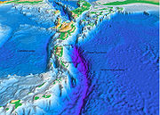
lies immediately to the south of the fault zone and the trench. The trench is 800 kilometres (497 mi) long and has a maximum depth of 8000 metres (26,247 ft) at Milwaukee Deep
Milwaukee Deep
Milwaukee Deep, also known as The Milwaukee Depth, is the deepest part of the Atlantic Ocean and is part of the Puerto Rico Trench. It has a maximum depth of at least . It is just north of the coast of Puerto Rico at Punto Palmas Altas in Manatí.This ocean floor feature is named for the USS...
, which is the deepest point in the Atlantic Ocean and the deepest point not in the Pacific Ocean
Pacific Ocean
The Pacific Ocean is the largest of the Earth's oceanic divisions. It extends from the Arctic in the north to the Southern Ocean in the south, bounded by Asia and Australia in the west, and the Americas in the east.At 165.2 million square kilometres in area, this largest division of the World...
.
Geology
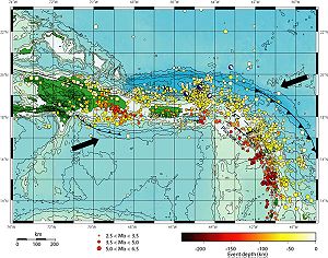
The Puerto Rico Trench is located at a boundary between two plates that pass each other along a transform boundary with only a small component of subductionSubduction
In geology, subduction is the process that takes place at convergent boundaries by which one tectonic plate moves under another tectonic plate, sinking into the Earth's mantle, as the plates converge. These 3D regions of mantle downwellings are known as "Subduction Zones"...
. The Caribbean Plate
Caribbean Plate
The Caribbean Plate is a mostly oceanic tectonic plate underlying Central America and the Caribbean Sea off the north coast of South America....
is moving to the east while the North American Plate
North American Plate
The North American Plate is a tectonic plate covering most of North America, Greenland, Cuba, Bahamas, and parts of Siberia, Japan and Iceland. It extends eastward to the Mid-Atlantic Ridge and westward to the Chersky Range in eastern Siberia. The plate includes both continental and oceanic crust...
is moving to the west. The North American Plate is being subducted by the Caribbean Plate to the southeast of the trench. This subduction zone explains the presence of active volcano
Volcano
2. Bedrock3. Conduit 4. Base5. Sill6. Dike7. Layers of ash emitted by the volcano8. Flank| 9. Layers of lava emitted by the volcano10. Throat11. Parasitic cone12. Lava flow13. Vent14. Crater15...
es over the southeastern part of the Caribbean Sea. Volcanic activity is frequent along the island arc southeast from Puerto Rico to the coast of South America
South America
South America is a continent situated in the Western Hemisphere, mostly in the Southern Hemisphere, with a relatively small portion in the Northern Hemisphere. The continent is also considered a subcontinent of the Americas. It is bordered on the west by the Pacific Ocean and on the north and east...
.
Puerto Rico, the United States Virgin Islands
United States Virgin Islands
The Virgin Islands of the United States are a group of islands in the Caribbean that are an insular area of the United States. The islands are geographically part of the Virgin Islands archipelago and are located in the Leeward Islands of the Lesser Antilles.The U.S...
, British Virgin Islands
British Virgin Islands
The Virgin Islands, often called the British Virgin Islands , is a British overseas territory and overseas territory of the European Union, located in the Caribbean to the east of Puerto Rico. The islands make up part of the Virgin Islands archipelago, the remaining islands constituting the U.S...
, and the Dominican Republic
Dominican Republic
The Dominican Republic is a nation on the island of La Hispaniola, part of the Greater Antilles archipelago in the Caribbean region. The western third of the island is occupied by the nation of Haiti, making Hispaniola one of two Caribbean islands that are shared by two countries...
do not have active volcanoes; however, they are at risk from earthquake
Earthquake
An earthquake is the result of a sudden release of energy in the Earth's crust that creates seismic waves. The seismicity, seismism or seismic activity of an area refers to the frequency, type and size of earthquakes experienced over a period of time...
s and tsunami
Tsunami
A tsunami is a series of water waves caused by the displacement of a large volume of a body of water, typically an ocean or a large lake...
s. The Puerto Rico Trench is capable of producing earthquakes greater than magnitude 8.0.
Public awareness
Knowledge of the earthquake and tsunami risks has not been widespread among the general public of the islands located near the trench.Since 1988, the Puerto Rican Seismic Society has been trying to use the Puerto Rican
Puerto Rico
Puerto Rico , officially the Commonwealth of Puerto Rico , is an unincorporated territory of the United States, located in the northeastern Caribbean, east of the Dominican Republic and west of both the United States Virgin Islands and the British Virgin Islands.Puerto Rico comprises an...
media to inform people about a future earthquake that could result in a catastrophic tragedy.
Following the 2004 tsunami
2004 Indian Ocean earthquake
The 2004 Indian Ocean earthquake was an undersea megathrust earthquake that occurred at 00:58:53 UTC on Sunday, December 26, 2004, with an epicentre off the west coast of Sumatra, Indonesia. The quake itself is known by the scientific community as the Sumatra-Andaman earthquake...
that affected more than forty countries in the Indian Ocean
Indian Ocean
The Indian Ocean is the third largest of the world's oceanic divisions, covering approximately 20% of the water on the Earth's surface. It is bounded on the north by the Indian Subcontinent and Arabian Peninsula ; on the west by eastern Africa; on the east by Indochina, the Sunda Islands, and...
, many more people now fear of the consequences that such an event would bring to the Caribbean. Local governments have begun emergency planning. In the case of Puerto Rico and the U.S. Virgin Islands, the United States
United States
The United States of America is a federal constitutional republic comprising fifty states and a federal district...
government has been studying the problem for years and is increasing its seismic investigations and developing tsunami warning systems. As of 2007 a recent study conducted by the United States Geological Survey shows that the probability of a major temblor in the area is between 33-55%, in other words high.
Earthquake history
1918 Puerto Rico earthquake
The San Fermín earthquake, also known as the Puerto Rico earthquake of 1918, was a major earthquake that struck the island of Puerto Rico at 10:14am on October 11, 1918. The magnitude for the earthquake has been reported at around 7.5 ; however, that might not be an exact number...
and caused a tsunami
Tsunami
A tsunami is a series of water waves caused by the displacement of a large volume of a body of water, typically an ocean or a large lake...
. In 1953, Santo Domingo
Santo Domingo
Santo Domingo, known officially as Santo Domingo de Guzmán, is the capital and largest city in the Dominican Republic. Its metropolitan population was 2,084,852 in 2003, and estimated at 3,294,385 in 2010. The city is located on the Caribbean Sea, at the mouth of the Ozama River...
, Dominican Republic
Dominican Republic
The Dominican Republic is a nation on the island of La Hispaniola, part of the Greater Antilles archipelago in the Caribbean region. The western third of the island is occupied by the nation of Haiti, making Hispaniola one of two Caribbean islands that are shared by two countries...
, was affected by the Santo Domingo earthquake. The 1918 earthquake was caused by an old left-lateral strike-slip fault near the Mona passage. The actual subduction zone (Puerto Rico Trench) hasn't ruptured in over 200 years, a major concern to geophysicists.
Puerto Rico in particular has always been an area of concern to earthquake experts because, apart from the 1918 episode, there are frequent cases of tremors in and around the island. A 1981 tremor was felt across the island, while another in 1985 was felt in the towns of Cayey
Cayey, Puerto Rico
Cayey is a mountain town in central Puerto Rico located on the Central Mountain range, north of Salinas and Guayama; south of Cidra and Caguas; east of Aibonito and Salinas; and west of San Lorenzo Cayey is spread over 21 wards and Cayey Pueblo...
and Salinas
Salinas, Puerto Rico
Salinas is a small municipality in the southern part of Puerto Rico located in the southern coast of the island, south of Aibonito and Cayey; southeast of Coamo, east of Santa Isabel; and west of Guayama...
.
| Earthquake location | Year | Magnitude |
|---|---|---|
| Puerto Rico Trench | |
|
| Anegada Trough | |
|
| Mona Canyon | |
|
| Mona Canyon | |
|
| Dominican Republic | |
|
| Dominican Republic | |