
North Downs
Encyclopedia
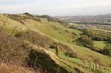
The North Downs are a ridge of chalk
hills in south east England
that stretch from Farnham
in Surrey
to the White Cliffs of Dover
in Kent
. The North Downs lie within two Areas of Outstanding Natural Beauty
(AONBs), the Surrey Hills
and the Kent Downs
. The North Downs Way
National Trail runs along the North Downs from Farnham
to Dover
.
- which run roughly parallel to them but some 50 km (31 mi) to the south.
The narrow spine of the Hog's Back
between Farnham and Guildford
forms the western extremity of the North Downs whilst the cliffs between Folkestone
and Deal
terminate the ridge in the east. There are two distinct aspects, the steep south facing escarpment
and the gentle north facing dip slope
. The southern boundary is defined by the foot of the escarpment which gives way to the flat, broad clay lands between the Downs and Greensand Ridge
known as the Vale of Holmesdale. The northern boundary is less apparent but occurs where the chalk submerges below the more recent Paleocene
deposits.
The Downs are highest near the Kent-Surrey border, often reaching heights in excess of 200 metres above sea level at the crest of the escarpment. The highest point is Botley Hill
in Surrey at 267 metres (876 ft). The highest point in London, Westerham Heights, is located on the North Downs. East of the Medway Valley the Downs become broader and flatter, extending as far as the Isle of Thanet
.
The ridge is intersected by the valleys of a series of rivers: the Wey, Mole
, Darent
, Medway
and Stour
rivers. These drain much of the Weald
to the south, the western ones are tributaries of the Thames
; they carve steep valleys through the chalk and provide natural corridor routes. In addition to existing rivers, the Downs are crossed by a number of wind gaps – fossil river valleys no longer occupied by rivers, including those at Farnham, Betchworth, Caterham
, Lyminge
and Hawkinge
. Except for the river valleys and wind gaps, the crest of the escarpment
is almost continuous along its length. The dip slope
is dissected by many small dry valley
s, and in the broad eastern part in Kent, by further river valleys such as that of the Little Stour
. Leith Hill
is sometimes incorrectly referred to as part of the North Downs but is located on the parallel Greensand Ridge
and does not consist of chalk.
 The Downland
of the North Downs consists of distinct lithostratigraphic features (the types of strata, the names of which are always capitalized):
The Upper Greensand marks the southern edge of the Downs, being underlain by:
The topography of the North Downs mainly consists of the Chalk Formation, the rock strata of the Upper Cretaceous period which in certain areas is overlain by superficial deposits of gravels or clay-with-flints.
Citing Dr D. T. Aldiss of the British Geological Survey:
and rabbit
grazing which prevents scrub encroachment. It has been noted that chalk grassland to the west of the Medway Valley is dominated by Upright Brome
(Bromus erectus) and Fescue
(Festuca) whilst grassland to the east is dominated by Tor-grass
(Brachypodium pinnatum). Because of the close proximity of the North Downs to the continent, the warm climate and the south facing escarpment several plant species survive on the chalk grassland which are scarce or not found elsewhere in the British Isles.
The nationally rare Late Spider Orchid
(Ophrys fuciflora) is limited within the British Isles to chalk grassland between Folkestone
and Wye. One of the two native British sites for the nationally rare Monkey Orchid
(Orchis simia) is on the North Downs. The nationally scarce Man Orchid
(Orchis anthropophora) is not uncommon on chalk grassland on the downs in Surrey and Kent. Other scarce plant species such as Early Gentian
(Gentiana anglica ), Dwarf Milkwort
(Polygala amarella) and Bedstraw Broomrape
(Orobanche caryophyllacea) also occur on chalk grassland in the North Downs.
Chalk grassland also supports a rich fauna, particularly of insects. Notable butterfly species include Adonis Blue
(Lysandra bellargus) and Silver-spotted Skipper (Hesperia comma) which may be found on warm, sheltered, south facing slopes. The chalk downland above the Stour Valley is the only British site for the Black-veined Moth (Siona lineata). Other notable moth species that occur on the North Downs include the Fiery Clearwing Moth (Bembecia chrysidiformis) and Straw Belle Moth (Aspitates gilvaria).
Woodland was far more extensive on the North Downs prior to human clearance 4000 to 5000 years ago. Fragments still remain particularly where the layer of clay with flints overlying the chalk has inhibited clearance. Where this is the case species such as Pedunculate Oak
(Quercus robur) predominate although much woodland has been replanted with conifer and Sweet Chestnut
(Castanea sativa). In Surrey, there are localised areas of chalk heath where heathland and chalkland plants grow alongside each other.
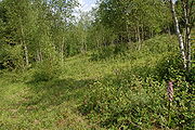 Calcaerous woodland occurs on thin soils where chalk is close to the surface. These conditions are most often found on the escarpment of the North Downs and on valley slopes but may also occur on the plateau of the dip slope. Calcaerous woodland is typically dominated by Beech
(Fagus), Hornbeam
(Carpinus betulus), Yew (Taxus baccata) and Ash (Fraxinus excelsior). Box Hill
comprises one of the largest areas of native Box
(Buxus sempervirens) woodland in England. One notable species characteristic of calcaerous woodland is the nationally scarce Lady Orchid
(Orchis purpurea) which is found in more than 100 sites on the Kent stretch of the North Downs although it is confined to just two sites elsewhere in the UK.
On the summit of the cliffs between Deal, Kent
and Folkestone the Early Spider Orchid (Ophrys Sphegodes) occurs in large numbers as well as the rare Oxtongue Broomrape
(Orobanche artemisae campestris). Naturally exposed chalk is rare inland with the exception of the river cliffs formed by the Mole
on the west face of Box Hill and at Ham Bank in Norbury Park
. However, quarry lakes within chalk pits provide habitat for Great Crested Newt
(Triturus cristatus). The scarce Musk Orchid
(Herminium monorchis) has colonised disused chalk pits near Hollingbourne
in Kent.
, approximately 400,000 years ago at Barnfield Pit
near Swanscombe
provides the earliest evidence of human occupation in the North Downs. It is suggested that human activity at this time coincided with intermittent warm phases during the last glacial period and that continuous occupation of the Downs did not occur until warming after the glaciation. Flint axes have also been found on river terraces at Farnham, on Walton and Banstead Heaths and on the crest of the escarpment above Folkestone. There is considerable evidence of Mesolithic
activity in the Surrey Downs through the discovery of pit-dwellings at Weston Woods near Albury
and the quantity of discarded tools, microliths and other implements discovered.
At about 3000 BC the emergence of Neolithic culture saw the lifestyle of the Mesolithic hunter-gatherer shift to a more sedentary and communal lifestyle that relied upon the keeping of livestock and the growing of crops. There is substantial evidence of Neolithic
activity within the North Downs, notably the long barrow
s concentrated in the Medway and Stour valleys. The Medway long barrows
, which include Kit's Coty House
and Coldrum Stones
are constructed of sarsen stone
, locally found on Blue Bell Hill
and the valleys of the dip slope, whilst the Stour Valley long barrows are constructed of earth.
has been an important activity that has taken place on the downs for centuries. Today, the woodland that remains largely exists where deforestation has been inhibited by steep slopes or the layer of clay with flints which is difficult to plough. Because of the many small farms that have survived on the downs, a network of narrow lanes and minor roads has developed. This has resulted in a landscape similar to that found in Normandy known as bocage. The predominant type of farming on the Downs is arable farming and this increased greatly during the twentieth century. Pastoral farming also occurs but to a lesser extent. Human settlements within the downs have generally formed in sheltered valleys and at the foot of scarp slope (known as spring line settlements). The Downs has in recent years seen the plantation of vineyards along the southern slopes, in particular the Denbies Wine Estate
, Dorking
, which is the largest vineyard in the country, accounting for 10% of the country's vines. The chalky soils make the area similar to the Champagne region.
There is plenty of evidence of chalk extraction on the Downs particularly along the scarp slope. Oil drilling at the foot of the downs occurs in several locations in Surrey. The Kent coalfield was established in the late 19th century after coal was found in 1890. Four collieries produced a successful output and lasted throughout the 20th century - Betteshanger, Snowdown, Tilmanstone and Chislet. The east to west ridge of the downs has provided a natural transport route for centuries. Much of the historic Pilgrims' Way still survives at the foot of the scarp slope and this has been joined much more recently by the M20 motorway
. The scarp slope has also been used for fortification and many examples of this still exist such as Thurnham Castle and on Castle Hill, Folkestone Castle Hill near Folkestone.
such as Box Hill
and Langdon Cliffs
. Other areas of interest are Newland's Corner, Wye Downs
and the Hog's Back
. Much chalk grassland and ancient woodland on the downs is open-access and there are also many historic sites on the downs such as Kit's Coty House
near Maidstone and Dover Castle
.
Chalk
Chalk is a soft, white, porous sedimentary rock, a form of limestone composed of the mineral calcite. Calcite is calcium carbonate or CaCO3. It forms under reasonably deep marine conditions from the gradual accumulation of minute calcite plates shed from micro-organisms called coccolithophores....
hills in south east England
England
England is a country that is part of the United Kingdom. It shares land borders with Scotland to the north and Wales to the west; the Irish Sea is to the north west, the Celtic Sea to the south west, with the North Sea to the east and the English Channel to the south separating it from continental...
that stretch from Farnham
Farnham
Farnham is a town in Surrey, England, within the Borough of Waverley. The town is situated some 42 miles southwest of London in the extreme west of Surrey, adjacent to the border with Hampshire...
in Surrey
Surrey
Surrey is a county in the South East of England and is one of the Home Counties. The county borders Greater London, Kent, East Sussex, West Sussex, Hampshire and Berkshire. The historic county town is Guildford. Surrey County Council sits at Kingston upon Thames, although this has been part of...
to the White Cliffs of Dover
White cliffs of Dover
The White Cliffs of Dover are cliffs which form part of the British coastline facing the Strait of Dover and France. The cliffs are part of the North Downs formation. The cliff face, which reaches up to , owes its striking façade to its composition of chalk accentuated by streaks of black flint...
in Kent
Kent
Kent is a county in southeast England, and is one of the home counties. It borders East Sussex, Surrey and Greater London and has a defined boundary with Essex in the middle of the Thames Estuary. The ceremonial county boundaries of Kent include the shire county of Kent and the unitary borough of...
. The North Downs lie within two Areas of Outstanding Natural Beauty
Area of Outstanding Natural Beauty
An Area of Outstanding Natural Beauty is an area of countryside considered to have significant landscape value in England, Wales or Northern Ireland, that has been specially designated by the Countryside Agency on behalf of the United Kingdom government; the Countryside Council for Wales on...
(AONBs), the Surrey Hills
Surrey Hills AONB
The Surrey Hills is a Area of Outstanding Natural Beauty , located in Surrey, England. The AONB was designated in 1958 and covers one quarter of the county of Surrey...
and the Kent Downs
Kent Downs AONB
Kent Downs is an Area of Outstanding Natural Beauty in Kent, England . They are the eastern half of the North Downs and stretch from the London/Surrey borders to the White Cliffs of Dover...
. The North Downs Way
North Downs Way
The North Downs Way is a long-distance path in southern England, opened in 1978. It runs from Farnham to Dover, past Godalming, Guildford, Dorking, Merstham, Otford and Rochester, along the Surrey Hills Area of Outstanding Natural Beauty and Kent Downs AONB.East of Boughton Lees, the path splits...
National Trail runs along the North Downs from Farnham
Farnham
Farnham is a town in Surrey, England, within the Borough of Waverley. The town is situated some 42 miles southwest of London in the extreme west of Surrey, adjacent to the border with Hampshire...
to Dover
Dover
Dover is a town and major ferry port in the home county of Kent, in South East England. It faces France across the narrowest part of the English Channel, and lies south-east of Canterbury; east of Kent's administrative capital Maidstone; and north-east along the coastline from Dungeness and Hastings...
.
Etymology
'Downs' is from Old English dun meaning, amongst other things, 'hill'. The word acquired the sense of 'elevated rolling grassland' around the fourteenth century. These hills are prefixed 'north' to distinguish them from the morphologically similar range of hills - the South DownsSouth Downs
The South Downs is a range of chalk hills that extends for about across the south-eastern coastal counties of England from the Itchen Valley of Hampshire in the west to Beachy Head, near Eastbourne, East Sussex, in the east. It is bounded on its northern side by a steep escarpment, from whose...
- which run roughly parallel to them but some 50 km (31 mi) to the south.
Geography
The narrow spine of the Hog's Back
Hog's Back
The Hog's Back is a part of the North Downs in Surrey, England, that lies between Farnham, Surrey in the west and Guildford in the east.-Name:Compared with the main part of the Downs to the east of it, it is a narrow elongated ridge, hence its name....
between Farnham and Guildford
Guildford
Guildford is the county town of Surrey. England, as well as the seat for the borough of Guildford and the administrative headquarters of the South East England region...
forms the western extremity of the North Downs whilst the cliffs between Folkestone
Folkestone
Folkestone is the principal town in the Shepway District of Kent, England. Its original site was in a valley in the sea cliffs and it developed through fishing and its closeness to the Continent as a landing place and trading port. The coming of the railways, the building of a ferry port, and its...
and Deal
Deal, Kent
Deal is a town in Kent England. It lies on the English Channel eight miles north-east of Dover and eight miles south of Ramsgate. It is a former fishing, mining and garrison town...
terminate the ridge in the east. There are two distinct aspects, the steep south facing escarpment
Escarpment
An escarpment is a steep slope or long cliff that occurs from erosion or faulting and separates two relatively level areas of differing elevations.-Description and variants:...
and the gentle north facing dip slope
Dip slope
A dip slope is a geological formation often created by erosion of tilted strata. Dip slopes are found on homoclinal ridges with one side that is steep and irregular and another side, the dip slope, that is generally planar with a dip parallel to the bedding...
. The southern boundary is defined by the foot of the escarpment which gives way to the flat, broad clay lands between the Downs and Greensand Ridge
Greensand Ridge
The Greensand Ridge is an extensive, prominent, often heavily wooded, sandstone escarpment and range of hills in south-east England. It runs in a horseshoe shape around the Weald of Surrey, Sussex and Kent. It reaches its highest elevation, , at Leith Hill in Surrey—the second highest point...
known as the Vale of Holmesdale. The northern boundary is less apparent but occurs where the chalk submerges below the more recent Paleocene
Paleocene
The Paleocene or Palaeocene, the "early recent", is a geologic epoch that lasted from about . It is the first epoch of the Palaeogene Period in the modern Cenozoic Era...
deposits.
The Downs are highest near the Kent-Surrey border, often reaching heights in excess of 200 metres above sea level at the crest of the escarpment. The highest point is Botley Hill
Botley Hill
Botley Hill is a hill in Surrey located on the North Downs with a height of . It is the highest point on the North Downs excluding the roughly parallel Greensand Ridge to the south...
in Surrey at 267 metres (876 ft). The highest point in London, Westerham Heights, is located on the North Downs. East of the Medway Valley the Downs become broader and flatter, extending as far as the Isle of Thanet
Isle of Thanet
The Isle of Thanet lies at the most easterly point of Kent, England. While in the past it was separated from the mainland by the nearly -wide River Wantsum, it is no longer an island ....
.
The ridge is intersected by the valleys of a series of rivers: the Wey, Mole
River Mole, Surrey
The River Mole is a tributary of the River Thames in southern England. It rises in West Sussex near Gatwick Airport and flows north west through Surrey for to the Thames near Hampton Court Palace. The river gives its name to the Surrey district of Mole Valley...
, Darent
River Darent
The River Darent or River Darenth is a Kentish tributary of the River Thames in England. Its name is believed to be from a Celtic word meaning 'river where oak-trees grow'...
, Medway
River Medway
The River Medway, which is almost entirely in Kent, England, flows for from just inside the West Sussex border to the point where it enters the Thames Estuary....
and Stour
River Stour, Kent
The River Stour is the river in Kent, England that flows into the English Channel at Pegwell Bay. Above Plucks Gutter, where the Little Stour joins it, the river is normally known as the Great Stour. The upper section of the river, above its confluence with the East Stour at Ashford is sometimes...
rivers. These drain much of the Weald
Weald
The Weald is the name given to an area in South East England situated between the parallel chalk escarpments of the North and the South Downs. It should be regarded as three separate parts: the sandstone "High Weald" in the centre; the clay "Low Weald" periphery; and the Greensand Ridge which...
to the south, the western ones are tributaries of the Thames
River Thames
The River Thames flows through southern England. It is the longest river entirely in England and the second longest in the United Kingdom. While it is best known because its lower reaches flow through central London, the river flows alongside several other towns and cities, including Oxford,...
; they carve steep valleys through the chalk and provide natural corridor routes. In addition to existing rivers, the Downs are crossed by a number of wind gaps – fossil river valleys no longer occupied by rivers, including those at Farnham, Betchworth, Caterham
Caterham
Caterham is a town in the Tandridge District of Surrey, England. The town is geographically divided into two sections: Caterham on the Hill and Caterham Valley - the main town centre. The town lies close to the A22, a few miles south of Croydon, in a valley cut into the dip slope of the North Downs...
, Lyminge
Lyminge
Lyminge is a village in southeast Kent, England. It lies about five miles from Folkestone and the Channel Tunnel, on the road passing through the Elham Valley. The Nailbourne stream begins in the village and flows north through the Valley, to become one of the tributary streams of the Great Stour...
and Hawkinge
Hawkinge
Hawkinge is a village and civil parish in the Shepway District of Kent, England. The original village of Hawkinge is actually just less than a mile due east of the present village centre ; the modern, much larger, village of Hawkinge was formed by the merging of Hawkinge and Uphill...
. Except for the river valleys and wind gaps, the crest of the escarpment
Escarpment
An escarpment is a steep slope or long cliff that occurs from erosion or faulting and separates two relatively level areas of differing elevations.-Description and variants:...
is almost continuous along its length. The dip slope
Dip slope
A dip slope is a geological formation often created by erosion of tilted strata. Dip slopes are found on homoclinal ridges with one side that is steep and irregular and another side, the dip slope, that is generally planar with a dip parallel to the bedding...
is dissected by many small dry valley
Dry valley
A dry valley is a valley found in either karst or chalk terrain that no longer has a surface flow of water.There are many examples of the latter along the North and South Downs in southern England...
s, and in the broad eastern part in Kent, by further river valleys such as that of the Little Stour
Little Stour
The Little Stour is one of the tributaries of the River Stour in the English county of Kent. The upper reaches of the river are better known as the Nailbourne, whilst the lower reaches were once known as the Seaton Navigation....
. Leith Hill
Leith Hill
Leith Hill to the south west of Dorking, Surrey, England, reaches above sea level, the highest point on the Greensand Ridge, and is the second highest point in south-east England, after Walbury Hill near Hungerford, West Berkshire, high....
is sometimes incorrectly referred to as part of the North Downs but is located on the parallel Greensand Ridge
Greensand Ridge
The Greensand Ridge is an extensive, prominent, often heavily wooded, sandstone escarpment and range of hills in south-east England. It runs in a horseshoe shape around the Weald of Surrey, Sussex and Kent. It reaches its highest elevation, , at Leith Hill in Surrey—the second highest point...
and does not consist of chalk.
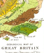
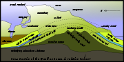
Geology
Downland
A downland is an area of open chalk hills. This term is especially used to describe the chalk countryside in southern England. Areas of downland are often referred to as Downs....
of the North Downs consists of distinct lithostratigraphic features (the types of strata, the names of which are always capitalized):
- The more level tops of the downs are often covered by acidic strata, usually including a layer of Clay-with-FlintsClay-with-FlintsIn geology, Clay-with-Flints was the name given by W. Whitaker in 1861 to a peculiar deposit of stiff red, brown or yellow clay containing unworn whole flints as well as angular shattered fragments, also with a variable admixture of rounded flint, quartz, quartzite and other pebbles...
, a sandy clay with many flints, or various sands and gravels (note: these are not shown on the geological map and section in this article).
- The Chalk FormationSouthern England Chalk FormationThe Chalk Formation of Southern England is a system of chalk downland in the south of England. The formation is perhaps best known for Salisbury Plain, the location of Stonehenge, the Isle of Wight and the twin ridgeways of the North Downs and South Downs....
, composed mostly of chalkChalkChalk is a soft, white, porous sedimentary rock, a form of limestone composed of the mineral calcite. Calcite is calcium carbonate or CaCO3. It forms under reasonably deep marine conditions from the gradual accumulation of minute calcite plates shed from micro-organisms called coccolithophores....
(the rock type), a kind of soft fine-grained limestone. It is formed of three parts, the Upper Chalk, which has many flints, the Middle Chalk, with fewer flints, and the Lower Chalk or Coombe Rock, greyish, with few flints. The chalk is most commonly exposed on slopes or as cliffs, where the overlying acidic strata have been quarried or washed away. The buried upper surface of the chalk beneath the acidic strata is often eroded into pipes, gulleys and pinnacles, sometimes visible in road cuttings and quarries.
- The Upper Greensand Formation, a whitish, limy sandstone, often used for building, for which it has been mined from beneath the chalk (for example from the Godstone Baby Mines). The Upper Greensand of the North Downs is a thin bed of one or two metres thickness, and it is rarely visible at the surface (it is much thicker elsewhere).
The Upper Greensand marks the southern edge of the Downs, being underlain by:
- The Gault Formation of stiff blue clay.
- The Lower Greensand Formation of Lower Cretaceous age, containing greensand, a glauconite sand or sandstone, as well as a certain amount of silts, clays, ironstone and limestone.
The topography of the North Downs mainly consists of the Chalk Formation, the rock strata of the Upper Cretaceous period which in certain areas is overlain by superficial deposits of gravels or clay-with-flints.
Citing Dr D. T. Aldiss of the British Geological Survey:
Ecology
The North Downs support several important habitats. The most distinctive of these is chalk grassland which is largely limited to steep escarpment and valley slopes. This semi-natural habitat is maintained through sheep, cattleCattle
Cattle are the most common type of large domesticated ungulates. They are a prominent modern member of the subfamily Bovinae, are the most widespread species of the genus Bos, and are most commonly classified collectively as Bos primigenius...
and rabbit
Rabbit
Rabbits are small mammals in the family Leporidae of the order Lagomorpha, found in several parts of the world...
grazing which prevents scrub encroachment. It has been noted that chalk grassland to the west of the Medway Valley is dominated by Upright Brome
Bromus
Bromus is a large genus of the grass family . Estimates in the scientific literature of the number of species have ranged from 100 to 400, but plant taxonomists currently recognize around 160–170 species...
(Bromus erectus) and Fescue
Fescue
Festuce is a genus of about 300 species of perennial tufted grasses, belonging to the grass family Poaceae . The genus has a cosmopolitan distribution, although the majority of the species are found in cool temperate areas...
(Festuca) whilst grassland to the east is dominated by Tor-grass
Tor-grass
Tor-grass is a plant in the grass family, with a widespread distribution in temperate regions of the Northern Hemisphere. It typically grows in calcareous grassland, and reaches 70–120 cm tall. The flowerhead is open, with 10 to 15 erect spikelets.The caterpillars of some Lepidoptera use it...
(Brachypodium pinnatum). Because of the close proximity of the North Downs to the continent, the warm climate and the south facing escarpment several plant species survive on the chalk grassland which are scarce or not found elsewhere in the British Isles.
The nationally rare Late Spider Orchid
Ophrys
The genus Ophrys is a large group of orchids from the alliance Orchis in the subtribe Orchidinae. There are many natural hybrids. The type species is Ophrys insectifera L.1753...
(Ophrys fuciflora) is limited within the British Isles to chalk grassland between Folkestone
Folkestone
Folkestone is the principal town in the Shepway District of Kent, England. Its original site was in a valley in the sea cliffs and it developed through fishing and its closeness to the Continent as a landing place and trading port. The coming of the railways, the building of a ferry port, and its...
and Wye. One of the two native British sites for the nationally rare Monkey Orchid
Orchis simia
The Monkey orchid is an orchid species of the Orchis genus. It is known for its pungent odor, which some say is similar to that of feces.-References:...
(Orchis simia) is on the North Downs. The nationally scarce Man Orchid
Man orchid
Orchis anthropophora, the Man Orchid , is a European species of orchid whose flowers resemble a human figure. The head is formed by the petals and sepals, and the suspended torso and limbs by the lobes of the labellum...
(Orchis anthropophora) is not uncommon on chalk grassland on the downs in Surrey and Kent. Other scarce plant species such as Early Gentian
Gentian
Gentiana is a genus of flowering plants belonging to the Gentian family , tribe Gentianeae and monophyletic subtribe Gentianinae. With about 400 species, it is considered a large genus.-Habitat:...
(Gentiana anglica ), Dwarf Milkwort
Polygala
Polygala is a genus of about 500 species of flowering plants belonging to the family Polygalaceae, commonly known as milkwort or snakeroot...
(Polygala amarella) and Bedstraw Broomrape
Broomrape
Broomrape or Broom-rape is a genus of over 200 species of parasitic herbaceous plants in the family Orobanchaceae, mostly native to the temperate Northern Hemisphere. Some species formerly included in this genus are now referred to the genus Conopholis.The broomrape plant is small, from...
(Orobanche caryophyllacea) also occur on chalk grassland in the North Downs.
Chalk grassland also supports a rich fauna, particularly of insects. Notable butterfly species include Adonis Blue
Adonis Blue
The Adonis Blue is a butterfly in the family Lycaenidae.-Habitat:The preferred habitat of the adonis blue is calcareous grasslands with hot and dry conditions.-Species decline:...
(Lysandra bellargus) and Silver-spotted Skipper (Hesperia comma) which may be found on warm, sheltered, south facing slopes. The chalk downland above the Stour Valley is the only British site for the Black-veined Moth (Siona lineata). Other notable moth species that occur on the North Downs include the Fiery Clearwing Moth (Bembecia chrysidiformis) and Straw Belle Moth (Aspitates gilvaria).
Woodland was far more extensive on the North Downs prior to human clearance 4000 to 5000 years ago. Fragments still remain particularly where the layer of clay with flints overlying the chalk has inhibited clearance. Where this is the case species such as Pedunculate Oak
Pedunculate Oak
Quercus robur is commonly known as the Pedunculate Oak or English oak. It is native to most of Europe, and to Anatolia to the Caucasus, and also to parts of North Africa.-Taxonomy:Q...
(Quercus robur) predominate although much woodland has been replanted with conifer and Sweet Chestnut
Sweet Chestnut
Castanea sativa is a species of the flowering plant family Fagaceae, the tree and its edible seeds are referred to by several common names such Sweet Chestnut or Marron. Originally native to southeastern Europe and Asia Minor, it is now widely dispersed throughout Europe and parts of Asia, such as...
(Castanea sativa). In Surrey, there are localised areas of chalk heath where heathland and chalkland plants grow alongside each other.
European Beech
Fagus sylvatica, the European Beech or Common Beech, is a deciduous tree belonging to the beech family Fagaceae.-Natural range:...
(Fagus), Hornbeam
European Hornbeam
Carpinus betulus is a hornbeam native to eastern, western, central and southern England. It requires a warm climate for good growth, and occurs only at elevations up to 600 metres...
(Carpinus betulus), Yew (Taxus baccata) and Ash (Fraxinus excelsior). Box Hill
Box Hill, Surrey
Box Hill is a summit of the North Downs in Surrey, approximately south west of London. The hill takes its name from the ancient box woodland found on the steepest west-facing chalk slopes overlooking the River Mole. The western part of the hill is owned and managed by the National Trust, whilst...
comprises one of the largest areas of native Box
Buxus sempervirens
Buxus sempervirens is a flowering plant in the genus Buxus, native to western and southern Europe, northwest Africa, and southwest Asia, from southern England south to northern Morocco, and east through the northern Mediterranean region to Turkey. Buxus colchica of western Caucasus and B...
(Buxus sempervirens) woodland in England. One notable species characteristic of calcaerous woodland is the nationally scarce Lady Orchid
Lady orchid
The Lady Orchid is an herbaceous plant belonging to the Genus Orchis of the family Orchidaceae.-Description: Orchis purpurea reaches on average of height. The leaves are broad and oblong-lanceolate, forming a rosette about the base of the plant and surrounding the flower spike. They are fleshy...
(Orchis purpurea) which is found in more than 100 sites on the Kent stretch of the North Downs although it is confined to just two sites elsewhere in the UK.
On the summit of the cliffs between Deal, Kent
Deal, Kent
Deal is a town in Kent England. It lies on the English Channel eight miles north-east of Dover and eight miles south of Ramsgate. It is a former fishing, mining and garrison town...
and Folkestone the Early Spider Orchid (Ophrys Sphegodes) occurs in large numbers as well as the rare Oxtongue Broomrape
Broomrape
Broomrape or Broom-rape is a genus of over 200 species of parasitic herbaceous plants in the family Orobanchaceae, mostly native to the temperate Northern Hemisphere. Some species formerly included in this genus are now referred to the genus Conopholis.The broomrape plant is small, from...
(Orobanche artemisae campestris). Naturally exposed chalk is rare inland with the exception of the river cliffs formed by the Mole
River Mole, Surrey
The River Mole is a tributary of the River Thames in southern England. It rises in West Sussex near Gatwick Airport and flows north west through Surrey for to the Thames near Hampton Court Palace. The river gives its name to the Surrey district of Mole Valley...
on the west face of Box Hill and at Ham Bank in Norbury Park
Norbury Park
Norbury Park is a swathe of land arranged around a small manor house near Leatherhead and Dorking, Surrey, which appears in the Domesday Book of 1086. The manor was also known as Northbury for some time....
. However, quarry lakes within chalk pits provide habitat for Great Crested Newt
Great Crested Newt
The Great Crested Newt, also called Northern Crested Newt or Warty Newt is a newt in the family Salamandridae, found across Europe and parts of Asia.-Distribution:...
(Triturus cristatus). The scarce Musk Orchid
Musk Orchid
The musk orchid is a commonly occurring species of European orchid.-Status in Britain:Musk orchids have a localised distribution in Britain. Sites where it is found include Ham Hill in Wiltshire....
(Herminium monorchis) has colonised disused chalk pits near Hollingbourne
Hollingbourne
Hollingbourne is a village and civil parish in the Maidstone District of Kent, England. The parish is located on the southward slope of the North Downs to the east of the county town, Maidstone. The parish population is almost 1000 persons and includes Hollingbourne village as well as Broad...
in Kent.
History
The discovery of worked flints and human and animal remains dating from the Lower PaleolithicLower Paleolithic
The Lower Paleolithic is the earliest subdivision of the Paleolithic or Old Stone Age. It spans the time from around 2.5 million years ago when the first evidence of craft and use of stone tools by hominids appears in the current archaeological record, until around 300,000 years ago, spanning the...
, approximately 400,000 years ago at Barnfield Pit
Swanscombe Heritage Park
Swanscombe Heritage Park is a National Nature Reserve and a Site of Special Scientific Interest near the village of Swanscombe in north-west Kent, England, at the Thames east of London...
near Swanscombe
Swanscombe
Swanscombe is a small town, part of the Borough of Dartford on the north Kent coast in England. It is part of the civil parish of Swanscombe and Greenhithe.-Prehistory:...
provides the earliest evidence of human occupation in the North Downs. It is suggested that human activity at this time coincided with intermittent warm phases during the last glacial period and that continuous occupation of the Downs did not occur until warming after the glaciation. Flint axes have also been found on river terraces at Farnham, on Walton and Banstead Heaths and on the crest of the escarpment above Folkestone. There is considerable evidence of Mesolithic
Mesolithic
The Mesolithic is an archaeological concept used to refer to certain groups of archaeological cultures defined as falling between the Paleolithic and the Neolithic....
activity in the Surrey Downs through the discovery of pit-dwellings at Weston Woods near Albury
Albury, Surrey
Albury is a village and civil parish in the borough of Guildford in Surrey, England, about south-east of Guildford town centre. The village is within an Area of Outstanding Natural Beauty and Site of Special Scientific Interest....
and the quantity of discarded tools, microliths and other implements discovered.
At about 3000 BC the emergence of Neolithic culture saw the lifestyle of the Mesolithic hunter-gatherer shift to a more sedentary and communal lifestyle that relied upon the keeping of livestock and the growing of crops. There is substantial evidence of Neolithic
Neolithic
The Neolithic Age, Era, or Period, or New Stone Age, was a period in the development of human technology, beginning about 9500 BC in some parts of the Middle East, and later in other parts of the world. It is traditionally considered as the last part of the Stone Age...
activity within the North Downs, notably the long barrow
Long barrow
A long barrow is a prehistoric monument dating to the early Neolithic period. They are rectangular or trapezoidal tumuli or earth mounds traditionally interpreted as collective tombs...
s concentrated in the Medway and Stour valleys. The Medway long barrows
Medway megaliths
The Medway megaliths or Medway tombs are names given to a group of Neolithic chambered long barrows and other megaliths located in the lower valley of the River Medway in the English county of Kent...
, which include Kit's Coty House
Kit's Coty House
Kit's Coty House or Kit's Coty is the name of the remains of a Neolithic chambered long barrow on Blue Bell Hill near Aylesford in the English county of Kent. It is one of the Medway megaliths....
and Coldrum Stones
Coldrum Stones
The Coldrum Stones are the remains of a Neolithic chambered long barrow near Trottiscliffe in the English county of Kent.The monument has been greatly affected by 19th century treasure hunters and chalk extraction but the kerb of 31 peristaliths largely survives, meaning that it is often mistaken...
are constructed of sarsen stone
Sarsen
Sarsen stones are sandstone blocks found in quantity in the United Kingdom on Salisbury Plain, the Marlborough Downs, in Kent, and in smaller quantities in Berkshire, Essex, Oxfordshire, Dorset and Hampshire...
, locally found on Blue Bell Hill
Blue Bell Hill
Blue Bell Hill is a chalk hill between Maidstone and Rochester in the English county of Kent. It overlooks the River Medway and is part of the North Downs. Settlements on the hill include Walderslade; and Blue Bell Hill and Kit's Coty villages...
and the valleys of the dip slope, whilst the Stour Valley long barrows are constructed of earth.
Agriculture and industry
The landscape of the Downs has been greatly shaped by man. DeforestationDeforestation
Deforestation is the removal of a forest or stand of trees where the land is thereafter converted to a nonforest use. Examples of deforestation include conversion of forestland to farms, ranches, or urban use....
has been an important activity that has taken place on the downs for centuries. Today, the woodland that remains largely exists where deforestation has been inhibited by steep slopes or the layer of clay with flints which is difficult to plough. Because of the many small farms that have survived on the downs, a network of narrow lanes and minor roads has developed. This has resulted in a landscape similar to that found in Normandy known as bocage. The predominant type of farming on the Downs is arable farming and this increased greatly during the twentieth century. Pastoral farming also occurs but to a lesser extent. Human settlements within the downs have generally formed in sheltered valleys and at the foot of scarp slope (known as spring line settlements). The Downs has in recent years seen the plantation of vineyards along the southern slopes, in particular the Denbies Wine Estate
Denbies Wine Estate
Denbies Wine Estate near Dorking, Surrey has the largest vineyard in England with under vines, representing over 10% of the plantings in the whole of the United Kingdom. It has a visitors' centre which attracts around 300,000 visitors a year....
, Dorking
Dorking
Dorking is a historic market town at the foot of the North Downs approximately south of London, in Surrey, England.- History and development :...
, which is the largest vineyard in the country, accounting for 10% of the country's vines. The chalky soils make the area similar to the Champagne region.
There is plenty of evidence of chalk extraction on the Downs particularly along the scarp slope. Oil drilling at the foot of the downs occurs in several locations in Surrey. The Kent coalfield was established in the late 19th century after coal was found in 1890. Four collieries produced a successful output and lasted throughout the 20th century - Betteshanger, Snowdown, Tilmanstone and Chislet. The east to west ridge of the downs has provided a natural transport route for centuries. Much of the historic Pilgrims' Way still survives at the foot of the scarp slope and this has been joined much more recently by the M20 motorway
M20 motorway
The M20 is a motorway in Kent, England. It runs from the M25 motorway to Folkestone, providing a link to the Channel Tunnel and the ports at Dover. It is long...
. The scarp slope has also been used for fortification and many examples of this still exist such as Thurnham Castle and on Castle Hill, Folkestone Castle Hill near Folkestone.
Places of interest
Many beauty spots on the North Downs are owned by the National TrustNational Trust for Places of Historic Interest or Natural Beauty
The National Trust for Places of Historic Interest or Natural Beauty, usually known as the National Trust, is a conservation organisation in England, Wales and Northern Ireland...
such as Box Hill
Box Hill, Surrey
Box Hill is a summit of the North Downs in Surrey, approximately south west of London. The hill takes its name from the ancient box woodland found on the steepest west-facing chalk slopes overlooking the River Mole. The western part of the hill is owned and managed by the National Trust, whilst...
and Langdon Cliffs
White cliffs of Dover
The White Cliffs of Dover are cliffs which form part of the British coastline facing the Strait of Dover and France. The cliffs are part of the North Downs formation. The cliff face, which reaches up to , owes its striking façade to its composition of chalk accentuated by streaks of black flint...
. Other areas of interest are Newland's Corner, Wye Downs
Wye Downs
Wye Downs is a stretch of chalk downland and woodland located on the North Downs near the village of Wye in Kent. The site is a National Nature Reserve owned and managed by Natural England and comprises several coombes formed by periglacial action during the last ice age...
and the Hog's Back
Hog's Back
The Hog's Back is a part of the North Downs in Surrey, England, that lies between Farnham, Surrey in the west and Guildford in the east.-Name:Compared with the main part of the Downs to the east of it, it is a narrow elongated ridge, hence its name....
. Much chalk grassland and ancient woodland on the downs is open-access and there are also many historic sites on the downs such as Kit's Coty House
Kit's Coty House
Kit's Coty House or Kit's Coty is the name of the remains of a Neolithic chambered long barrow on Blue Bell Hill near Aylesford in the English county of Kent. It is one of the Medway megaliths....
near Maidstone and Dover Castle
Dover Castle
Dover Castle is a medieval castle in the town of the same name in the English county of Kent. It was founded in the 12th century and has been described as the "Key to England" due to its defensive significance throughout history...
.
See also
- Geology of the United Kingdom
- Southern England Chalk FormationSouthern England Chalk FormationThe Chalk Formation of Southern England is a system of chalk downland in the south of England. The formation is perhaps best known for Salisbury Plain, the location of Stonehenge, the Isle of Wight and the twin ridgeways of the North Downs and South Downs....
- Chalk figures in the United Kingdom