

Fault scarp
Encyclopedia
Topography
Topography is the study of Earth's surface shape and features or those ofplanets, moons, and asteroids...
expression of faulting attributed to the displacement of the land surface by movement along faults. They are exhibited either by differential movement and subsequent erosion
Erosion
Erosion is when materials are removed from the surface and changed into something else. It only works by hydraulic actions and transport of solids in the natural environment, and leads to the deposition of these materials elsewhere...
along an old inactive geologic fault
Geologic fault
In geology, a fault is a planar fracture or discontinuity in a volume of rock, across which there has been significant displacement along the fractures as a result of earth movement. Large faults within the Earth's crust result from the action of tectonic forces...
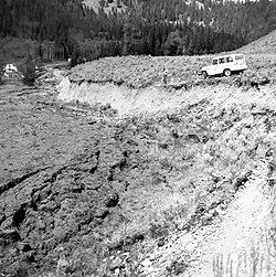
(a sort of old rupture), or by a movement on a recent active fault. Fault scarps often contain highly fractured rock of both hard and weak consistency. In many cases, bluffs form from the upthrown block and can be very steep. The height of the scarp formation is equal to the vertical displacement along the fault. Active scarps are usually formed by tectonic displacement, e.g. when an earthquake
Earthquake
An earthquake is the result of a sudden release of energy in the Earth's crust that creates seismic waves. The seismicity, seismism or seismic activity of an area refers to the frequency, type and size of earthquakes experienced over a period of time...
changes the elevation of the ground, and can be caused by any type of fault, including strike-slip faults, whose motion is primarily horizontal. This movement is usually episodic, with the height of the bluffs being the result of multiple movements over time. Displacement of around 5 to 10 meters per tectonic event is common.
Due to the dramatic uplift along the fault, the fault scarp is very prone to erosion, especially if the material being uplifted consists of unconsolidated sediment. Weathering, mass wasting and water runoff can soon wear down these bluffs. Fault scarps may be only a few centimeters or many meters high. Fault-line scarps are coincident with faults, but are most typically formed by the erosion of weaker rocks that have been brought alongside more resistant ones by the movement along the fault. In the case of old eroded fault scarps, active erosion may have moved the physical cliff
Cliff
In geography and geology, a cliff is a significant vertical, or near vertical, rock exposure. Cliffs are formed as erosion landforms due to the processes of erosion and weathering that produce them. Cliffs are common on coasts, in mountainous areas, escarpments and along rivers. Cliffs are usually...
back away from the actual fault location which may be buried beneath a talus
Scree
Scree, also called talus, is a term given to an accumulation of broken rock fragments at the base of crags, mountain cliffs, or valley shoulders. Landforms associated with these materials are sometimes called scree slopes or talus piles...
, alluvial fan
Alluvial fan
An alluvial fan is a fan-shaped deposit formed where a fast flowing stream flattens, slows, and spreads typically at the exit of a canyon onto a flatter plain. A convergence of neighboring alluvial fans into a single apron of deposits against a slope is called a bajada, or compound alluvial...
or the valley fill.
Notable characteristics
The rapid erosion of these bluffs can create defined V-shaped valleys along runoff channels. Adjacent V-shaped valley formations give the remaining fault spurs a very triangular shape. This formation is known as a triangular facet; however, this landform is not limited to fault scarps.Examples
Teton Range
The Teton Range is a mountain range of the Rocky Mountains in North America. A north-south range, it is on the Wyoming side of the state's border with Idaho, just south of Yellowstone National Park. Most of the range is in Grand Teton National Park....
in Wyoming
Wyoming
Wyoming is a state in the mountain region of the Western United States. The western two thirds of the state is covered mostly with the mountain ranges and rangelands in the foothills of the Eastern Rocky Mountains, while the eastern third of the state is high elevation prairie known as the High...
is an example of an active fault scarp. The dramatic topography of the Tetons is due to the geologically recent activity on the Teton fault. The Hurricane Cliffs, west of Zion National Park
Zion National Park
Zion National Park is located in the Southwestern United States, near Springdale, Utah. A prominent feature of the park is Zion Canyon, which is 15 miles long and up to half a mile deep, cut through the reddish and tan-colored Navajo Sandstone by the North Fork of the Virgin River...
in Utah
Utah
Utah is a state in the Western United States. It was the 45th state to join the Union, on January 4, 1896. Approximately 80% of Utah's 2,763,885 people live along the Wasatch Front, centering on Salt Lake City. This leaves vast expanses of the state nearly uninhabited, making the population the...
is a prominent example of a fault scarp along an old, essentially inactive, fault. Other examples include the scarps bounding the East African Rift Valley
Great Rift Valley
The Great Rift Valley is a name given in the late 19th century by British explorer John Walter Gregory to the continuous geographic trench, approximately in length, that runs from northern Syria in Southwest Asia to central Mozambique in South East Africa...
and the Rio Grande Rift
Rio Grande Rift
The Rio Grande Rift is a north-trending continental rift zone. It separates the Colorado Plateau in the west from the interior of the North American craton on the east. The rift extends from central Colorado in the north to the state of Chihuahua, Mexico in the south. The rift zone consists of four...
in New Mexico
New Mexico
New Mexico is a state located in the southwest and western regions of the United States. New Mexico is also usually considered one of the Mountain States. With a population density of 16 per square mile, New Mexico is the sixth-most sparsely inhabited U.S...
.
In other parts of the world, many fault scarp
Scarp
-Landforms and geology:* Cliff, a significant vertical, or near vertical, rock exposure* Escarpment, a steep slope or long cliff that occurs from erosion or faulting and separates two relatively level areas of differing elevations...
s exist in the Eastern and Western Alps
Alps
The Alps is one of the great mountain range systems of Europe, stretching from Austria and Slovenia in the east through Italy, Switzerland, Liechtenstein and Germany to France in the west....
. In New Zealand
New Zealand
New Zealand is an island country in the south-western Pacific Ocean comprising two main landmasses and numerous smaller islands. The country is situated some east of Australia across the Tasman Sea, and roughly south of the Pacific island nations of New Caledonia, Fiji, and Tonga...
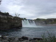
a large scarp can be seen at Maruia Falls on the Shenandoah Highway
Shenandoah Highway
State Highway 65 is a New Zealand State Highway in the South Island. It is 71 km long and runs south to north down the Maruia river valley from SH 7 at Springs Junction, 15 km west of the main divide at the Lewis Pass, to SH 6 in the Buller Gorge, 11 km west of Murchison...
, South Island
South Island
The South Island is the larger of the two major islands of New Zealand, the other being the more populous North Island. It is bordered to the north by Cook Strait, to the west by the Tasman Sea, to the south and east by the Pacific Ocean...
. The 1929 Murchison earthquake
1929 Murchison earthquake
The 1929 Murchison earthquake occurred at 10:17 AM on 17 June. It struck the Murchison region of South Island, with an estimated magnitude of 7.8, and was felt throughout New Zealand. There were 17 casualties, mostly as a result of landslides triggered by the earthquake...
raised the upstream side by about four metres, thereby creating a fault scarp and, as a result, also a waterfall
Waterfall
A waterfall is a place where flowing water rapidly drops in elevation as it flows over a steep region or a cliff.-Formation:Waterfalls are commonly formed when a river is young. At these times the channel is often narrow and deep. When the river courses over resistant bedrock, erosion happens...
.