

Dorrigo Plateau
Encyclopedia
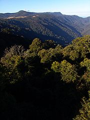
Plateau
In geology and earth science, a plateau , also called a high plain or tableland, is an area of highland, usually consisting of relatively flat terrain. A highly eroded plateau is called a dissected plateau...
in northern New South Wales
New South Wales
New South Wales is a state of :Australia, located in the east of the country. It is bordered by Queensland, Victoria and South Australia to the north, south and west respectively. To the east, the state is bordered by the Tasman Sea, which forms part of the Pacific Ocean. New South Wales...
, which forms part of the Great Dividing Range
Great Dividing Range
The Great Dividing Range, or the Eastern Highlands, is Australia's most substantial mountain range and the third longest in the world. The range stretches more than 3,500 km from Dauan Island off the northeastern tip of Queensland, running the entire length of the eastern coastline through...
. The plateau is sometimes referred to as the Dorrigo & Guy Fawkes Plateau.
The town of Dorrigo
Dorrigo, New South Wales
Dorrigo is a small town located on the Waterfall Way in northern New South Wales, Australia. It is approximately 580 kilometres north of the state capital, Sydney via the Pacific Highway, and 60 kilometres from the coastal city of Coffs Harbour. The town is situated on the Dorrigo Plateau near the...
, 580 kilometres north of the Sydney
Sydney
Sydney is the most populous city in Australia and the state capital of New South Wales. Sydney is located on Australia's south-east coast of the Tasman Sea. As of June 2010, the greater metropolitan area had an approximate population of 4.6 million people...
and 60 kilometres from the coastal city of Coffs Harbour
Coffs Harbour, New South Wales
-History:By the early 1900s, the Coffs Harbour area had become an important timber production centre. Before the opening of the North Coast Railway Line, the only way to transport large items of heavy but low value, such as timber, was by coastal shipping. This meant sawmillers on the North Coast...
, is located on the eastern edge.
Richard Craig
Richard Craig (adventurer)
Richard Craig was a free settler in the colony of New South Wales, a convicted criminal, an escaped convict, and a pardoned convict who worked as a stockman and drover.-Early life:...
was the first European to discover the Plateau, following the traditional indigenous route to Armidale, New South Wales
Armidale, New South Wales
Armidale is a city in the Northern Tablelands, New South Wales, Australia. Armidale Dumaresq Shire had a population of 19,485 people according to the 2006 census. It is the administrative centre for the Northern Tablelands region...
from the Grafton
Grafton, New South Wales
The city of Grafton is the commercial hub of the Clarence River Valley. Established in 1851, Grafton features many historic buildings and tree-lined streets. Located approximately 630 kilometres north of Sydney and 340 km south of Brisbane, Grafton and the Clarence Valley can be reached...
area. Using his skills as a horseman, Craig travelled along the western side of the Nymboida River
Nymboida River
The Nymboida River is a river in the Northern Rivers region of New South Wales in Australia. The headwaters of the river rise approximately 30 kilometres to the west of Dorrigo in the New England National Park near Barren Mountain....
. Craig's track became a road, now roughly following the same path as the present Grafton to Armidale Rd and travelling through the present day villages of Nymboida, Billy's Creek, Dundurrabin, Tyringham and Ebor (elevation 1300m). Timbergetters followed Craig through the sub tropical rainforest and many sawmills grew due to demand for timber, initially the highly prized Australian Red Cedar (Toona australis).
Today, the main access road traversing the plateau from east to west is the Waterfall Way
Waterfall Way
The Waterfall Way is a road and State Highway 78 in New South Wales, Australia. It runs east-west from the Pacific Highway to the New England Highway at Armidale. The route passes through some of New South Wales' most scenic countryside and has become well known as New South Wales best and...
.
The Dorrigo Plateau and surrounding Guy Fawkes area was created by successive basalt
Basalt
Basalt is a common extrusive volcanic rock. It is usually grey to black and fine-grained due to rapid cooling of lava at the surface of a planet. It may be porphyritic containing larger crystals in a fine matrix, or vesicular, or frothy scoria. Unweathered basalt is black or grey...
ic lava
Lava
Lava refers both to molten rock expelled by a volcano during an eruption and the resulting rock after solidification and cooling. This molten rock is formed in the interior of some planets, including Earth, and some of their satellites. When first erupted from a volcanic vent, lava is a liquid at...
flows from the Ebor Volcano covering the original granite base. Weathering from high rainfall caused an escarpment to form as the more ancient rocks underneath remained intact.