

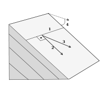
Strike and dip
Encyclopedia
Bed (geology)
In geology a bed is the smallest division of a geologic formation or stratigraphic rock series marked by well-defined divisional planes separating it from layers above and below. A bed is the smallest lithostratigraphic unit, usually ranging in thickness from a centimeter to several meters and...
, fault, or other planar feature is a line representing the intersection of that feature with a horizontal plane. On a geologic map
Geologic map
A geologic map or geological map is a special-purpose map made to show geological features. Rock units or geologic strata are shown by color or symbols to indicate where they are exposed at the surface...
, this is represented with a short straight line segment oriented parallel to the strike line. Strike (or strike angle) can be given as either a quadrant compass bearing of the strike line (N25°E for example) or in terms of east or west of true north or south, a single three digit number representing the azimuth, where the lower number is usually given (where the example of N25°E would simply be 025, and the other value of 205 is discarded), or the azimuth number followed by the degree sign (example of N25°E would be 25° or 205°). The dip gives the steepest angle of descent of a tilted bed or feature relative to a horizontal plane, and is given by the number (0°-90°) as well as a letter (N,S,E,W) with rough direction in which the bed is dipping. One technique is to always take the strike so the dip is 90° to the right of the strike, in which case the redundant letter following the dip angle is omitted. The map symbol is a short line attached and at right angles to the strike symbol pointing in the direction which the planar surface is dipping down. The angle of dip is generally included on a geologic map without the degree sign. Beds that are dipping vertically are shown with the dip symbol on both sides of the strike, and beds that are flat are shown like the vertical beds, but with a circle around them. Both vertical and flat beds do not have a number written with them.
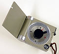
Strike and dip are determined in the field with a compass and clinometer or a combination of the two, such as a Brunton compass
Brunton compass
A Brunton compass, properly known as the Brunton Pocket Transit, is a type of precision compass made by Brunton, Inc. of Riverton, Wyoming. The instrument was patented in 1894 by a Canadian-born Colorado geologist named David W. Brunton. Unlike most modern compasses, the Brunton Pocket Transit...
named after D.W. Brunton a Colorado miner. Compass-clinometers which measure dip and dip direction in a single operation (as pictured) are often called "stratum" or "Klar" compasses after a German professor.
Any planar feature can be described by strike and dip. This includes sedimentary bedding, faults and fracture
Fracture
A fracture is the separation of an object or material into two, or more, pieces under the action of stress.The word fracture is often applied to bones of living creatures , or to crystals or crystalline materials, such as gemstones or metal...
s, cuesta
Cuesta
In structural geology and geomorphology, a cuesta is a ridge formed by gently tilted sedimentary rock strata in a homoclinal structure. Cuestas have a steep slope, where the rock layers are exposed on their edges, called an escarpment or, if more steep, a cliff...
s, igneous dikes
Dike (geology)
A dike or dyke in geology is a type of sheet intrusion referring to any geologic body that cuts discordantly across* planar wall rock structures, such as bedding or foliation...
and sills
Sill (geology)
In geology, a sill is a tabular sheet intrusion that has intruded between older layers of sedimentary rock, beds of volcanic lava or tuff, or even along the direction of foliation in metamorphic rock. The term sill is synonymous with concordant intrusive sheet...
, metamorphic
Metamorphism
Metamorphism is the solid-state recrystallization of pre-existing rocks due to changes in physical and chemical conditions, primarily heat, pressure, and the introduction of chemically active fluids. Mineralogical, chemical and crystallographic changes can occur during this process...
foliation
Foliation (geology)
Foliation is any penetrative planar fabric present in rocks. Foliation is common to rocks affected by regional metamorphic compression typical of orogenic belts. Rocks exhibiting foliation include the standard sequence formed by the prograde metamorphism of mudrocks; slate, phyllite, schist and...
and any other planar feature in the Earth. Linear features are measured with very similar methods, where "plunge" is the dip angle and "trend" is analogous to the dip direction value.
Apparent dip is the name of any dip measured in a plane that is not perpendicular to the strike line. True dip can be calculated from apparent dip using trigonometry if you know the strike. Geologic cross sections use apparent dip when they are drawn at some angle not perpendicular to strike.