
.gif)
Interstate 395 (Maryland)
Encyclopedia
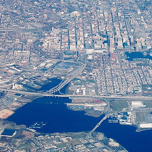
Interstate 395 is an Interstate Highway in the U.S. state of Maryland
. Known as Cal Ripken Way, the highway runs 1.33 miles (2.1 km) from I-95
north to Howard Street and Camden Street in Baltimore. I-395 is a spur that heads north from I-95 over the Middle Branch of the Patapsco River
toward Downtown Baltimore
, where it provides access to the Inner Harbor
and the Baltimore Convention Center
. The Interstate also serves the Camden Yards Sports Complex
, which contains M&T Bank Stadium
and Oriole Park at Camden Yards
, home of the Baltimore Ravens
and Baltimore Orioles
, respectively. I-395 has an unsigned 0.65 miles (1 km) spur designated I-395A that serves as the southernmost portion of Martin Luther King Jr. Boulevard, an urban arterial that provides a western bypass of downtown Baltimore. The Interstate and its spur are maintained by the Maryland Transportation Authority
(MdTA) and are a part of the National Highway System
.
just west of the interchange. The two-lane ramps from northbound I-95 to northbound I-395 and southbound I-395 to southbound I-95 pass over ramps from southbound I-95 to the southbound Baltimore-Washington Parkway
and from the northbound parkway to northbound I-95. The one-lane ramp from southbound I-395 to northbound I-95 splits from the southbound I-95 ramp where the Interstate becomes a viaduct over land. I-395, which carries six lanes, passes to the west of the Federal Hill neighborhood and to the east of M&T Bank Stadium and begins to parallel the Baltimore Light Rail
and CSX
's Baltimore Terminal Subdivision], which carries MARC
's Camden Line
.
 East of the stadium, two-lane flyover ramps from northbound I-395 to Martin Luther King Jr. Boulevard and from the boulevard to southbound I-395 leave and join the mainline. I-395 curves to due north as a four-lane freeway that gains one additional lane in each direction as the viaduct ends and the highway approaches its signed, limited access terminus at Conway Street adjacent to Camden Station
, the northern terminus of the Camden Line. The train station is just to the east of the B&O Warehouse
, which is just to the east of Oriole Park at Camden Yards. Conway Street heads east toward Light Street and the Inner Harbor. I-395 officially continues one block north along the western edge of the Baltimore Convention Center to a northern terminus at Camden Street adjacent to Sports Legends at Camden Yards
, which is in the Baltimore and Ohio Railroad
's original Camden Station building. The roadway continues north as Howard Street through downtown Baltimore.
Martin Luther King Jr. Boulevard, which is unsigned I-395A, curves west from its flyover ramps at I-395 to pass between the two stadiums. The four-lane freeway has one exit: a northbound ramp to Lee Street, which provides access to several parking lots at the Camden Yards Sports Complex. Both directions of Martin Luther King Jr. Boulevard receive a ramp from northbound Russell Street; there is also a ramp from southbound Martin Luther King Jr. Boulevard to southbound Russell Street. I-395A officially ends at the west end of the highway's bridge over Russell Street. Martin Luther King Jr. Boulevard continues north as a six-lane divided city-maintained street that passes along the western edge of downtown Baltimore on its way to connections with U.S. Route 40
and I-83
.
{| class=wikitable
!Mile
!Destinations
!Notes
|-
|0.00
|
|Southern terminus; directional T interchange
|-
|0.53
|Martin Luther King Jr. Boulevard north to Russell Street
|Officially I-395A; northbound exit and southbound entrance
|-
|1.24
|Conway Street – Inner Harbor
|Northern end of limited-access and signed section; no turn from southbound I-395 to eastbound Conway Street
|-
|1.33
|Howard Street north / Camden Street west
|Official northern terminus
Maryland
Maryland is a U.S. state located in the Mid Atlantic region of the United States, bordering Virginia, West Virginia, and the District of Columbia to its south and west; Pennsylvania to its north; and Delaware to its east...
. Known as Cal Ripken Way, the highway runs 1.33 miles (2.1 km) from I-95
Interstate 95
Interstate 95 is the main highway on the East Coast of the United States, running parallel to the Atlantic Ocean from Maine to Florida and serving some of the most populated urban areas in the country, including Boston, Providence, New Haven, New York City, Newark, Philadelphia, Baltimore,...
north to Howard Street and Camden Street in Baltimore. I-395 is a spur that heads north from I-95 over the Middle Branch of the Patapsco River
Patapsco River
The Patapsco River is a river in central Maryland which flows into Chesapeake Bay. The river's tidal portion forms the harbor for the city of Baltimore...
toward Downtown Baltimore
Downtown Baltimore
Downtown Baltimore is the section of Baltimore traditionally bounded by Martin Luther King, Jr. Boulevard to the west, Mt. Royal Avenue to the north, President Street to the east and the Inner Harbor area to the south. It consists of four neighborhoods: Westside, City Centre, Inner Harbor, and...
, where it provides access to the Inner Harbor
Inner Harbor
The Inner Harbor is a historic seaport, tourist attraction, and iconic landmark of the City of Baltimore, Maryland, United States. Described by the Urban Land Institute in 2009 as “the model for post-industrial waterfront redevelopment around the World.” The Inner Harbor is actually the end of the...
and the Baltimore Convention Center
Baltimore Convention Center
The Baltimore Convention Center is a convention and exhibition hall located in downtown Baltimore, Maryland. The Center is a municiple building owned and operated by the City of Baltimore...
. The Interstate also serves the Camden Yards Sports Complex
Camden Yards Sports Complex
The Camden Yards Sports Complex is located in Baltimore, Maryland. The complex is composed of Oriole Park at Camden Yards and M&T Bank Stadium, which are the stadiums for the Baltimore Orioles of Major League Baseball and the Baltimore Ravens of the National Football League, respectively...
, which contains M&T Bank Stadium
M&T Bank Stadium
M&T Bank Stadium is a multi-purpose football stadium located in Baltimore, Maryland. It is the home of the Baltimore Ravens of the National Football League. The stadium is immediately adjacent to Oriole Park at Camden Yards, the home of the Baltimore Orioles. Served by the Hamburg Street station of...
and Oriole Park at Camden Yards
Oriole Park at Camden Yards
Oriole Park at Camden Yards is a Major League Baseball ballpark located in Baltimore, Maryland. Home field of the Baltimore Orioles, it is the first of the "retro" major league ballparks constructed during the 1990s and early 2000s, and remains one of the most highly praised. The park was...
, home of the Baltimore Ravens
Baltimore Ravens
The Baltimore Ravens are a professional football franchise based in Baltimore, Maryland.The Baltimore Ravens are officially a quasi-expansion franchise, having originated in 1995 with the Cleveland Browns relocation controversy after Art Modell, then owner of the Cleveland Browns, announced his...
and Baltimore Orioles
Baltimore Orioles
The Baltimore Orioles are a professional baseball team based in Baltimore, Maryland in the United States. They are a member of the Eastern Division of Major League Baseball's American League. One of the American League's eight charter franchises in 1901, it spent its first year as a major league...
, respectively. I-395 has an unsigned 0.65 miles (1 km) spur designated I-395A that serves as the southernmost portion of Martin Luther King Jr. Boulevard, an urban arterial that provides a western bypass of downtown Baltimore. The Interstate and its spur are maintained by the Maryland Transportation Authority
Maryland Transportation Authority
The Maryland Transportation Authority is an independent state agency responsible for financing, constructing, operating, and maintaining eight toll facilities, currently consisting of two toll roads, two tunnels, and four bridges in Maryland...
(MdTA) and are a part of the National Highway System
National Highway System (United States)
The National Highway System is a network of strategic highways within the United States, including the Interstate Highway System and other roads serving major airports, ports, rail or truck terminals, railway stations, pipeline terminals and other strategic transport facilities.Individual states...
.
Route description
I-395 begins at a directional T interchange with I-95 that is entirely elevated above the Middle Branch of the Patapsco River, an estuary that receives Gwynns FallsGwynns Falls
Gwynns Falls is a stream located in Baltimore County and Baltimore City, Maryland. The headwaters are located in Reisterstown in Baltimore County, and the stream flows southeast, entering the city of Baltimore and emptying into the Middle Branch of the Patapsco River. The Patapsco drains into the...
just west of the interchange. The two-lane ramps from northbound I-95 to northbound I-395 and southbound I-395 to southbound I-95 pass over ramps from southbound I-95 to the southbound Baltimore-Washington Parkway
Baltimore-Washington Parkway
The Baltimore–Washington Parkway is a highway in the U.S. state of Maryland, running southwest from Baltimore to Washington, D.C. The road begins at an interchange with U.S. Route 50 and Maryland Route 201 near Cheverly in Prince George's County at the D.C...
and from the northbound parkway to northbound I-95. The one-lane ramp from southbound I-395 to northbound I-95 splits from the southbound I-95 ramp where the Interstate becomes a viaduct over land. I-395, which carries six lanes, passes to the west of the Federal Hill neighborhood and to the east of M&T Bank Stadium and begins to parallel the Baltimore Light Rail
Baltimore Light Rail
The Maryland Transit Administration Light Rail is a light rail system serving Baltimore, Maryland, United States, and the surrounding suburbs.In downtown Baltimore it uses city streets...
and CSX
CSX Transportation
CSX Transportation operates a Class I railroad in the United States known as the CSX Railroad. It is the main subsidiary of the CSX Corporation. The company is headquartered in Jacksonville, Florida, and owns approximately 21,000 route miles...
's Baltimore Terminal Subdivision], which carries MARC
MARC Train
MARC , known prior to 1984 as Maryland Rail Commuter Service, is a regional rail system comprising three lines in the Baltimore-Washington Metropolitan Area. MARC is administered by the Maryland Transit Administration , a Maryland Department of Transportation agency, and is operated under contract...
's Camden Line
Camden Line
The Camden Line is a MARC commuter rail line that runs between Union Station, Washington, D.C. and Camden Station, Baltimore, Maryland over the CSX Capital Subdivision. Service began along this route in 1835 as part of the Baltimore and Ohio Railroad , making it the oldest passenger rail line in...
.
Camden Station
Camden Station, now also referred to as Camden Yards, is a train station at the intersection of Howard and Camden Streets in Baltimore, Maryland, served by MARC commuter rail service and local Light Rail trains. It is adjacent to Oriole Park at Camden Yards...
, the northern terminus of the Camden Line. The train station is just to the east of the B&O Warehouse
B&O warehouse
The B&O Warehouse is a building in Baltimore, Maryland, adjacent to Oriole Park at Camden Yards. It was constructed by the Baltimore and Ohio Railroad beginning in 1899, with later sections completed in 1905, adjacent to the B&O's Camden Station and freight yard at Camden and Eutaw streets...
, which is just to the east of Oriole Park at Camden Yards. Conway Street heads east toward Light Street and the Inner Harbor. I-395 officially continues one block north along the western edge of the Baltimore Convention Center to a northern terminus at Camden Street adjacent to Sports Legends at Camden Yards
Sports Legends at Camden Yards
Sports Legends at Camden Yards is a non-profit sports museum in Baltimore, Maryland, United States, owned and operated by the Babe Ruth Birthplace & Museum. It opened on May 14, 2005, with the daughter of celebrated baseball player Babe Ruth in attendance...
, which is in the Baltimore and Ohio Railroad
Baltimore and Ohio Railroad
The Baltimore and Ohio Railroad was one of the oldest railroads in the United States and the first common carrier railroad. It came into being mostly because the city of Baltimore wanted to compete with the newly constructed Erie Canal and another canal being proposed by Pennsylvania, which...
's original Camden Station building. The roadway continues north as Howard Street through downtown Baltimore.
Martin Luther King Jr. Boulevard, which is unsigned I-395A, curves west from its flyover ramps at I-395 to pass between the two stadiums. The four-lane freeway has one exit: a northbound ramp to Lee Street, which provides access to several parking lots at the Camden Yards Sports Complex. Both directions of Martin Luther King Jr. Boulevard receive a ramp from northbound Russell Street; there is also a ramp from southbound Martin Luther King Jr. Boulevard to southbound Russell Street. I-395A officially ends at the west end of the highway's bridge over Russell Street. Martin Luther King Jr. Boulevard continues north as a six-lane divided city-maintained street that passes along the western edge of downtown Baltimore on its way to connections with U.S. Route 40
U.S. Route 40 in Maryland
U.S. Route 40 in the U.S. state of Maryland runs from western Maryland to Cecil County in the state's northeastern corner. With a total length of over , it is the longest numbered highway in Maryland. Almost half of the road overlaps with Interstate 68 or Interstate 70, while the old alignment...
and I-83
Interstate 83
Interstate 83 is an Interstate Highway in the eastern United States. Its southern terminus is in Baltimore, Maryland at the Fayette Street exit; its northern terminus is in Harrisburg, Pennsylvania at Interstate 81....
.
History
In 1969, the Design Concept Team, a multi-discipline group assembled in 1966 by the city government to help design freeway routings that would not disrupt the city's fabric, published the Baltimore 3-A Interstate and Boulevard System. In the 3-A system, I-395 was planned as a freeway spur from I-95 to the south edge of the central business district, connecting to a new route named City Boulevard (now known as Martin Luther King Jr. Boulevard). As routed in the 3-A System, I-95 would act as a bypass of the central business district, with I-395 providing direct access. On May 30, 2008, the Eastern Branch was officially dedicated for Cal Ripken, Jr., the Hall of Fame baseball player who played for the Baltimore Orioles from 1981 to 2001 and was elected to the Baseball Hall of Fame in 2007. The Eastern Branch is now called Cal Ripken Way from I-95 to Conway Street.Exit list
The entire route is in Baltimore.{| class=wikitable
!Mile
!Destinations
!Notes
|-
|0.00
|
|Southern terminus; directional T interchange
|-
|0.53
|Martin Luther King Jr. Boulevard north to Russell Street
|Officially I-395A; northbound exit and southbound entrance
|-
|1.24
|Conway Street – Inner Harbor
Inner Harbor
The Inner Harbor is a historic seaport, tourist attraction, and iconic landmark of the City of Baltimore, Maryland, United States. Described by the Urban Land Institute in 2009 as “the model for post-industrial waterfront redevelopment around the World.” The Inner Harbor is actually the end of the...
|Northern end of limited-access and signed section; no turn from southbound I-395 to eastbound Conway Street
|-
|1.33
|Howard Street north / Camden Street west
|Official northern terminus