
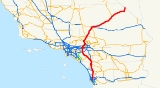
Interstate 15 in California
Encyclopedia
In the U.S. state
of California
, Interstate 15 is a major north–south route through the San Bernardino
, Riverside
, and San Diego
Counties, and it has a length of 287.26 miles (462.3 km) in the state. It is a major thoroughfare for traffic between Southern California
and Las Vegas, Nevada
, as well as points beyond. It is also the main route for traffic between San Diego
and the Inland Empire
.
, and it is eligible for designation as a state highway within the State Scenic Highway System
; however the state transportation authority, Caltrans, has not done so. There are various local names for the highway. between SR 163 and Pomerado Road/Miramar Road is known as the Semper Fi Highway in recognition of the nearby Marine Corps Air Station Miramar
. North of the Escondido city limits it is known as the Avocado Highway, whose designation ends upon entering Temecula. There are other local names as noted below.
Heading northward, I-15 currently begins at Interstate 8, at the same place that its continuation, State Route 15, begins its southward journey. goes through Mission Valley and intersects with State Route 52
, before merging with State Route 163. After traversing the Marine Corps Air Station Miramar
, I-15 comes into Rancho Penasquitos
, where it intersects with the end of State Route 56
. Northward, the route crosses Lake Hodges
inside the upper San Diego city limits. There are high-occupancy toll lanes in the center of I-15 from State Route 163 to Centre City Parkway, north of Via Rancho Parkway, in Escondido
.
into Escondido
, where it interchanges with State Route 78
. North of Escondido, I-15 goes through hilly terrain and farmland, intersecting State Route 76
(SR 79), before it crosses the county line into Riverside County
. In Riverside County, SR 79 runs concurrently with I-15 for a four-mile (6 km) portion in Temecula
, before it splits away running north to Hemet
. Then, intersects with the southern end of Interstate 215
, which continues the designation of the Escondido Freeway. Interstate 15 continues north as the Temecula Valley Freeway.
 splits from its first and only spur route in California, Interstate 215
, which runs through the two largest cities in the Inland Empire
, San Bernardino
and Riverside
. runs along the eastern edge of the Santa Ana Mountains
, passing the town of Lake Elsinore
. It continues through the suburban areas in the western Inland Empire, passing Corona
and Ontario, California
. The highway is then rejoined by I-215, before heading northwards and upward through the Cajon Pass
, an important mountain pass that is the primary route between Southern California and points eastwards and northeastwards.
 that is located between its northern and southern junctions with is also used by many local residents as the major north–south route for the western portions of the San Bernardino-Riverside-Ontario metropolitan area. serves a similar function in the eastern portion of the metropolitan area. These two highways are the only continuous north–south freeways in the area.)
North of Limonite Avenue (south of SR 60), I-15 is known as the Ontario Freeway. intersects State Route 60
, Interstate 10, and State Route 210
in rapid succession as it goes through Mira Loma
, Ontario
, and Rancho Cucamonga
. As it nears Devore
, merges with Interstate 215
, where it is called the Barstow Freeway or the Mojave Freeway.
 North of the Cajon Pass
, I-15 traverses the Mojave Desert
towns of Hesperia
and Victorville
. passes through desert for 30 miles (48.3 km) before reaching Barstow
, then continues past Zzyzx Road, before reaching the town of Baker
. The sign for Zzyzx Road
— alphabetically the last place name in the world — is a landmark of sorts on the drive between Los Angeles and Las Vegas. enters Nevada near the casino
town of Primm
, formerly known as Stateline, Nevada.
 thereafter to Las Vegas
, Salt Lake City
, and on into Idaho
and Montana
, before ending at the Canadian
border, where Alberta Highway 4 continues the ribbon of asphalt into Canada. Because it joins with the western end of I-70 in Southwestern Utah, also forms part of a major east–west corridor connecting Southern California with Denver
, St. Louis
, and points east.
The Mojave Freeway is fairly busy on weekdays, since it connects the rapidly growing exurbs
of the Victor Valley with the Los Angeles area. On weekends and holidays, however, it can sometimes be jammed
with California
ns driving to Las Vegas for short vacations.
Construction is currently underway to rehabilitate the pavement on and to add truck lanes to separate autos from truck traffic.
I-15 was initially planned to run from I-10 in San Bernardino along the current I-215 alignment then up through the Cajon Pass and on to Las Vegas, with a distance of 186.24 miles (299.7 km) within the state. California successfully argued the addition south to San Diego, suggesting that the freeway would connect the major military bases former March AFB
and former NAS (now MCAS) Miramar. US 395 was then signed TEMP-15 and the "old" I-15 between Devore
and San Bernardino became I-215.
On January 24, 1957, the State Highway Commission defined the Escondido Freeway as what are now Routes 15 and 215 from Route 805 to Route 91. This entire segment was previously U.S. Route-395 when it was named. Since then, the definition was extended on Route 15 south to Route 8 by Assembly Concurrent Resolution 34, Chapter 67 in 1979. Meanwhile, the segment of Route 15 from the San Diego County Line to the I-15/I-215 interchange was named the Temecula Valley Freeway in 1990.
The original definition for the Corona Freeway, as named by the State Highway Commission on July 23, 1958, stated that it was "Routes 71, 91, and 15 from Route 10 West of Pomona
to Route 215".
This legal definition has been amended twice: First in 1990, the California Assembly passed Concurrent Resolution 125, Chapter 78, renaming I-15 between the San Diego County
Line (which is further south from Interstate 215
) and Bundy Canyon Road near Lake Elsinore as the Temecula Valley Freeway.
Then in 1993, the California Assembly passed legislation officially designating State Route 71
as a part of the Chino Valley Freeway. However, the name "Corona Freeway" is, confusingly, sometimes still applied to this portion of State Route 71; despite the change, guide signs on eastbound and SR 57 southbound at the Kellogg Interchange
in Pomona still refer to SR 71 as the "Corona Freeway".
) in Corona
to pre-1964 Legislative Route 9 (now State Route 66
, and was extended north to pre-1964 Legislative Route 31 (present I-15 and in 1935. The piece south of U.S. Route 60 (Mission Boulevard), running along North Main Street, Hamner Avenue and Milliken Avenue, was state-maintained by 1955, but was not assigned a signed number. This was still the only existing piece in 1963, and had a planned freeway replacement to the east.
In the 1964 renumbering
, the route was assigned as State Route 31. It was added to the Interstate Highway System
in February 1972 as a realignment of Interstate 15 (the former alignment became Interstate 15E). Legislative changes were made in 1974, eliminating SR 31 (along with State Route 71 south of Corona) in favor of I-15. However, SR 31 continued to be signed — as temporary Interstate 15 - until present I-15 was finished. (A 1986 map shows state maintenance continuing north past SR 60 to Jurupa Street, where it turned east to I-15.)
to Interstate 8 in San Diego will be re-designated as part of I-15 once this segment is completely upgraded to Interstate standards.
Most of Interstate 15 is undergoing major improvements from Devore to the Nevada State Line, beginning in 2002 and costing $349 million. This project will improve traffic flow on the heavily traveled highway for those going to and from Las Vegas. Most of the construction was completed by Winter 2009. Projects include adding truck lanes on hills (39 miles or 62.8 km at various locations), repaving 76 miles (122.3 km) of at various locations, adding exit numbers, renovating and rehabilitating the rest area between Baker
and the Nevada State Line (Valley Wells Rest Area), reconstructing bridges in Baker
, and moving the agriculture inspection station from Yermo to the Nevada State Line and including a truck weigh station.
As of March 2008, construction is underway to add a northbound truck descending lane and to repave lanes between Bailey Rd. and Yates Well Rd.
There is also construction ongoing (circa spring 2008) to expand traffic lanes in northern San Diego County, including the northward extension (beyond SR 56) of the existing high-occupancy toll lanes which already exist between SR 56 and SR 163. It appears that this extension will move the northern terminus of the HOV lanes to a location at or near the interchange with SR 78.
{| class=wikitable
|-
!County
!Location
!Postmile
!Exit
!Destinations
!Notes
|-
|rowspan=35|San Diego
SD R6.13-R54.26
|rowspan=21|San Diego
|R6.13
|
|
|Continuation beyond I-8
|-
|
|6B
|Camino del Rio South
|
|-
|R6.13
|6B
|, Beaches
|
|-
|R6.82
|7
|Friars Road – Qualcomm Stadium
|Signed as exits 7A (east) and 7B (west) northbound
|-
|R8.37
|8
|Aero Drive
|
|-
|R9.24
|9
|Balboa Avenue, Tierrasanta Boulevard
|Former SR 274 west
|-
|R10.00
|10
|Clairemont Mesa Boulevard
|Southbound exit is part of exit 11
|-
|R10.58
|11
|
|
|-
|M12.12
|12
|
|Northbound exit is via exit 11; former US 395
south
|-
|M13.33
|13
|Miramar Way
|Serves Marine Corps Air Station Miramar
|-
|M14.29
|14
|Miramar Road, Pomerado Road
|
|-
|M15.00
|15
|Carroll Canyon Road
|
|-
|M15.92
|16
|Mira Mesa Boulevard
|
|-
|M17.31
|17
|Mercy Road, Scripps Poway Parkway
|
|-
|M18.18
|18
|
|
|-
|M19.47
|19
|
|
|-
|M20.57
|21
|Carmel Mountain Road
|
|-
|M21.92
|22
|Camino del Norte
|
|-
|M22.94
|23
|Bernardo Center Drive
|
|-
|M23.69
|24
|Rancho Bernardo Road
|
|-
|M26.03
|26
|
|
|-
|rowspan=8|Escondido
|M26.97
|27
|Via Rancho Parkway
|
|- style="background:#fdd;"
|M27.65
|28
|Centre City Parkway (I-15 Bus. north)
|Northbound exit and southbound entrance; former US 395
north
|-
|R28.77
|29
|Felicita Road
|
|-
|R30.09
|30
|9th Avenue, Auto Park Way
|
|-
|R30.63
|31
|Valley Parkway – Downtown Escondido
|
|-
|R31.52
|32
|
|
|-
|R32.86
|33
|El Norte Parkway
|
|- style="background:#fdd;"
|R33.92
|34
|Centre City Parkway (I-15 Bus. south)
|Southbound exit and northbound entrance; former US 395
south
|-
|
|R36.64
|37
|
|
|-
|
|R40.84
|41
|Gopher Canyon Road, Old Castle Road
|
|-
|
|R43.28
|43
|Old Highway 395
|Former US 395
|-
|
|R46.49
|46
|
|
|-
|
|R50.59
|51
|
|
|-
|
|R54.07
|54
|Rainbow Valley Boulevard
|
|-
|rowspan=29|Riverside
RIV R0.00-52.28
|rowspan=3|Temecula
| style="background:#dfd;"|3.44
| style="background:#dfd;"|58
| style="background:#dfd;"|
| style="background:#dfd;"|South end of SR 79 overlap, former SR 71
south
|-
|4.98
|59
|Rancho California Road, Old Town Front Street
|
|- style="background:#dfd;"
|6.62
|61
|
|North end of SR 79 overlap
|-
|Murrieta
|8.74
|63
|
|Southbound exit is via exit 64; former I-15E north / US 395
north
|-
|
|9.47
|64
|Murrieta Hot Springs Road
|
|-
|
|10.59
|65
|California Oaks Road
|
|-
|
|13.64
|68
|Clinton Keith Road
|
|-
|
|15.07
|69
|Baxter Road
|
|-
|
|16.30
|71
|Bundy Canyon Road
|
|-
|Lake Elsinore
|19.16
|73
|Diamond Drive, Railroad Canyon Road
|
|-
|
|20.95
|75
|Main Street (I-15 Bus. north)
|
|-
|
|22.28
|77
|
|
|-
|
|23.85
|78
|Nichols Road
|
|-
|
|26.69
|81
|Lake Street (I-15 Bus. south)
|
|-
|
|30.40
|85
|Indian Truck Trail
|
|-
|
|33.39
|88
|Temescal Canyon Road
|Former SR 71
|-
|
|35.64
|90
|Weirick Road
|
|-
|
|36.81
|91
|Cajalco Road
|
|-
|
|37.82
|92
|El Cerrito Road
|
|-
|rowspan=3|Corona
|38.69
|93
|Ontario Avenue
|Former SR 71
|-
|40.35
|95
|Magnolia Avenue
|
|-
|41.50
|96
|
|Signed as exits 96A (east) and 96B (west) southbound; former US 91
|-
|rowspan=3|Norco
|42.88
|97
|Hidden Valley Parkway
|
|-
|43.64
|98
|Second Street (I-15 Bus. north)
|
|-
|45.60
|100
|Sixth Street (I-15 Bus. south)
|
|-
|
| style="background:#ffdead;"|
| style="background:#ffdead;"|102
| style="background:#ffdead;"|Schleisman Road
| style="background:#ffdead;"|Proposed interchange
|-
|
|48.26
|103
|Limonite Avenue
|
|-
|
|
|105
|Cantu-Galleano Ranch Road
|
|-
|
|51.47
|106
|
|Signed as exits 106A (east) and 106B (west) northbound
|-
|rowspan=59|San Bernardino
SBD 0.00-186.24
|rowspan=2|Ontario
|1.02
|108
|Jurupa Street
|Former SR 31 south
|-
|2.39
|109
|
|Signed as exits 109A (west) and 109B (east) southbound
|-
|rowspan=5|Rancho Cucamonga
|3.05
|110
|4th Street
|
|-
|5.31
|112
|
|Former US 66
|-
|6.78
|113
|Baseline Road
|
|-
|8.35
|115
|
|Signed as exits 115A (east) and 115B (west) northbound and exits 115A (west) and 115B (east) southbound
|- style="background:#d3d3d3;"
|
|115
|Highland Avenue
|Closed
|-
|rowspan=3|Fontana
|9.61
|116
|Summit Avenue
|
|- style="background:#ffdead;"
|
|117
|Duncan Canyon Road
|Proposed interchange
|-
|12.84
|119
|Sierra Avenue
|
|-
|rowspan=2|San Bernardino
|15.65
|122
|Glen Helen Parkway
|
|-
|16.37
R13.78
|123
|
|Left exit southbound; former I-15E south / US 66
west / US 91 south / US 395
south
|-
|
|R14.96
|124
|Kenwood Avenue
|Former US 66
east
|-
|
|R20.01
|129
|Cleghorn Road
|Former US 66
west
|-
|
|R21.37
|131
|
|
|-
|
|R28.62
|138
|Oak Hill Road
|
|-
|
| style="background:#fdd;"|31.81
| style="background:#fdd;"|141
| style="background:#fdd;"|
| style="background:#fdd;"|Northbound exit and southbound entrance
|-
|
| style="background:#fdd;"|32.32
| style="background:#fdd;"|141
| style="background:#fdd;"|.svg.png) Joshua Street to US 395
Joshua Street to US 395
north
| style="background:#fdd;"|Southbound exit and northbound entrance
|-
|Hesperia
|34.00
|143
|Main Street – Hesperia
, Phelan
|
|-
|rowspan=7|Victorville
|37.59
|147
|Bear Valley Road – Lucerne Valley
|
|- style="background:#dfd;"
|40.51
|150
|
|South end of SR 18 overlap; former US 66
east / US 91 north
|-
|41.43
|151A
|Roy Rogers Drive
|
|-
|42.03
|151B
|Mojave Drive
|
|- style="background:#dfd;"
|43.49
|153A
|
|North end of SR 18 overlap; former US 66
/ US 91
|-
|43.62
|153B
|E Street
|
|-
|44.40
|154
|Stoddard Wells Road
|
|-
|
|47.39
|157
|Stoddard Wells Road – Bell Mountain
|
|-
|
|51.83
|161
|Dale Evans Parkway – Apple Valley
|
|-
|
|55.96
|165
|Wild Wash Road
|
|-
|
|60.16
|169
|Hodge Road
|
|-
|rowspan=8|Barstow
|65.84
|175
|Outlet Center Drive
|
|-
|68.77
|178
|Lenwood Road
|
|-
|70.10
|179
|
|
|-
|71.62
|181
|L Street, West Main Street (I-15 Bus. north)
|
|-
|73.54
|183
|
|
|-
|74.42
|184A
|
|Southbound exit is via exit 184
|-
|74.95
|184B
|East Main Street (I-15 Bus. south)
|Signed as exit 184 southbound; former US 66
|-
|76.88
|186
|Old Highway 58
|Former SR 58
west / US 91 south / US 466 west
|-
|
|79.59
|189
|Fort Irwin Road
|Serves Fort Irwin
|-
|
|R81.84
|191
|Ghost Town Road
|Serves the ghost town of Calico
|-
|rowspan=2|Yermo
|R84.64
|194
|Calico Road – Yermo
|
|-
|R86.38
|196
|Yermo Road – Yermo
|
|-
|
|R88.49
|198
|Minneola Road
|
|-
|
|R96.41
|206
|Harvard Road
|
|-
|
|R103.63
|213
|Field Road
|
|-
|
|R111.59
|221
|Afton Road
|
|-
|
|R120.42
|230
|Basin Road
|
|-
|
|R124.23
|233
|Rasor Road
|
|-
|Zzyzx
|R130.18
|239
|Zzyzx Road – Zzyzx
|
|-
|rowspan=3|Baker
| style="background:#fdd;"|R135.80
| style="background:#fdd;"|245
| style="background:#fdd;"|Baker Boulevard (I-15 Bus. north) – Baker
| style="background:#fdd;"|Northbound exit and southbound entrance; former US 91 north / US 466 east
|-
|R136.57
|246
|
|
|- style="background:#fdd;"
|R138.45
|248
|Baker Boulevard (I-15 Bus. south) – Baker
|Southbound exit and northbound entrance; former US 91 south / US 466 west
|-
|Halloran Springs
|149.60
|259
|Halloran Springs Road
|
|-
|
|155.57
|265
|Halloran Summit Road
|
|-
|Cima
|162.73
|272
|Cima Road
|
|-
|
|171.47
|281
|Bailey Road
|
|-
|
|176.45
|286
|Nipton Road
|
|-
|
|181.39
|291
|Yates Well Road
|
|-
|
|186.24
| colspan="3" style="text-align:center;"|Nevada state line
U.S. state
A U.S. state is any one of the 50 federated states of the United States of America that share sovereignty with the federal government. Because of this shared sovereignty, an American is a citizen both of the federal entity and of his or her state of domicile. Four states use the official title of...
of California
California
California is a state located on the West Coast of the United States. It is by far the most populous U.S. state, and the third-largest by land area...
, Interstate 15 is a major north–south route through the San Bernardino
San Bernardino County, California
San Bernardino County is a county in the U.S. state of California. As of the 2010 census, the population was 2,035,210, up from 1,709,434 as of the 2000 census...
, Riverside
Riverside County, California
Riverside County is a county in the U.S. state of California. One of 58 California counties, it covers in the southern part of the state, and stretches from Orange County to the Colorado River, which forms the state border with Arizona. The county derives its name from the city of Riverside,...
, and San Diego
San Diego County, California
San Diego County is a large county located in the southwestern corner of the US state of California. Hence, San Diego County is also located in the southwestern corner of the 48 contiguous United States. Its county seat and largest city is San Diego. Its population was about 2,813,835 in the 2000...
Counties, and it has a length of 287.26 miles (462.3 km) in the state. It is a major thoroughfare for traffic between Southern California
Southern California
Southern California is a megaregion, or megapolitan area, in the southern area of the U.S. state of California. Large urban areas include Greater Los Angeles and Greater San Diego. The urban area stretches along the coast from Ventura through the Southland and Inland Empire to San Diego...
and Las Vegas, Nevada
Las Vegas, Nevada
Las Vegas is the most populous city in the U.S. state of Nevada and is also the county seat of Clark County, Nevada. Las Vegas is an internationally renowned major resort city for gambling, shopping, and fine dining. The city bills itself as The Entertainment Capital of the World, and is famous...
, as well as points beyond. It is also the main route for traffic between San Diego
San Diego, California
San Diego is the eighth-largest city in the United States and second-largest city in California. The city is located on the coast of the Pacific Ocean in Southern California, immediately adjacent to the Mexican border. The birthplace of California, San Diego is known for its mild year-round...
and the Inland Empire
Inland Empire (California)
The Inland Empire is a region in Southern California. The region sits directly east of the Los Angeles metropolitan area. The Inland Empire most commonly is used in reference to the U.S. Census Bureau's federally-defined Riverside-San Bernardino-Ontario metropolitan area, which covers more than...
.
Route description
Interstate 15 is part of the California Freeway and Expressway SystemCalifornia Freeway and Expressway System
The California Freeway and Expressway System is a system of existing or planned freeways and expressways in the U.S. state of California. It is defined by the Streets and Highways Code.-List of roads in the system:*State Route 1 *State Route 2...
, and it is eligible for designation as a state highway within the State Scenic Highway System
State Scenic Highway System (California)
The State Scenic Highway System is a list of highways, mainly state highways, that have been designated by the California Department of Transportation as scenic highways. The California State Legislature, primarily through Section 263 of the Streets and Highways Code, makes highways eligible for...
; however the state transportation authority, Caltrans, has not done so. There are various local names for the highway. between SR 163 and Pomerado Road/Miramar Road is known as the Semper Fi Highway in recognition of the nearby Marine Corps Air Station Miramar
Marine Corps Air Station Miramar
Marine Corps Air Station Miramar , formerly Naval Air Station Miramar is a United States Marine Corps installation that is home to the 3rd Marine Aircraft Wing, which is the aviation element of the 1st Marine Expeditionary Force...
. North of the Escondido city limits it is known as the Avocado Highway, whose designation ends upon entering Temecula. There are other local names as noted below.
Heading northward, I-15 currently begins at Interstate 8, at the same place that its continuation, State Route 15, begins its southward journey. goes through Mission Valley and intersects with State Route 52
California State Route 52
State Route 52 is a state highway in the U.S. state of California in San Diego County, that extends from La Jolla Parkway at Interstate 5 in La Jolla to Route 67 in Santee. Route 52 is a freeway for its entire length...
, before merging with State Route 163. After traversing the Marine Corps Air Station Miramar
Marine Corps Air Station Miramar
Marine Corps Air Station Miramar , formerly Naval Air Station Miramar is a United States Marine Corps installation that is home to the 3rd Marine Aircraft Wing, which is the aviation element of the 1st Marine Expeditionary Force...
, I-15 comes into Rancho Penasquitos
Rancho Penasquitos, San Diego, California
Rancho Peñasquitos is a community in the northeastern part of the city of San Diego, California. It is named after the first Spanish Land Grant in the County - Rancho de Los Penasquitos. Peñasquitos means little cliffs in Spanish. It abuts Los Penasquitos canyon preserve - an open space...
, where it intersects with the end of State Route 56
California State Route 56
State Route 56 runs from Interstate 5 in the Carmel Valley neighborhood of San Diego to Interstate 15. Route 56 was originally planned in 1964 to connect to the north end of State Route 125 and continue east to State Route 67, but the city of Poway worked to make sure that would not be possible...
. Northward, the route crosses Lake Hodges
Lake Hodges
Lake Hodges is a lake and reservoir located in Southern California, about north of San Diego and just south of Escondido, California. When full, the reservoir has , a maximum water depth of , and of shoreline. Interstate 15 crosses Lake Hodges via the Lake Hodges Bridge...
inside the upper San Diego city limits. There are high-occupancy toll lanes in the center of I-15 from State Route 163 to Centre City Parkway, north of Via Rancho Parkway, in Escondido
Escondido, California
Escondido is a city occupying a shallow valley ringed by rocky hills, just north of the city of San Diego, California. Founded in 1888, it is one of the oldest cities in San Diego County. The city had a population of 143,911 at the 2010 census. Its municipal government set itself an operating...
.
into Escondido
Escondido, California
Escondido is a city occupying a shallow valley ringed by rocky hills, just north of the city of San Diego, California. Founded in 1888, it is one of the oldest cities in San Diego County. The city had a population of 143,911 at the 2010 census. Its municipal government set itself an operating...
, where it interchanges with State Route 78
California State Route 78
State Route 78 is a state highway in the U.S. state of California in the United States that runs from Oceanside east to Blythe, traversing nearly the entire width of the state. Its western terminus is at Interstate 5 in San Diego County and its eastern terminus is at I-10 in Riverside County...
. North of Escondido, I-15 goes through hilly terrain and farmland, intersecting State Route 76
California State Route 76
State Route 76 is a state highway in the U.S. state of California. It is an important east–west route in the North County region of San Diego County that begins in Oceanside near Interstate 5 and continues east past Interstate 15 to State Route 79...
(SR 79), before it crosses the county line into Riverside County
Riverside County, California
Riverside County is a county in the U.S. state of California. One of 58 California counties, it covers in the southern part of the state, and stretches from Orange County to the Colorado River, which forms the state border with Arizona. The county derives its name from the city of Riverside,...
. In Riverside County, SR 79 runs concurrently with I-15 for a four-mile (6 km) portion in Temecula
Temecula, California
Temecula is a city in southwestern Riverside County, California, United States with a population of 100,097 according to the 2010 United States Census, making it the lowest populated American city over 100,000 population. It was incorporated on December 1, 1989...
, before it splits away running north to Hemet
Hemet, California
Hemet is a city in the San Jacinto Valley in Riverside County, California, United States. It covers a total area of , about half of the valley, which it shares with the neighboring city of San Jacinto. The population was 78,657 at the 2010 census....
. Then, intersects with the southern end of Interstate 215
Interstate 215 (California)
Interstate 215 is a long north–south Interstate highway in the Inland Empire region of Southern California. It is an auxiliary route of Interstate 15 , running from Murrieta to northern San Bernardino...
, which continues the designation of the Escondido Freeway. Interstate 15 continues north as the Temecula Valley Freeway.
Interstate 215 (California)
Interstate 215 is a long north–south Interstate highway in the Inland Empire region of Southern California. It is an auxiliary route of Interstate 15 , running from Murrieta to northern San Bernardino...
, which runs through the two largest cities in the Inland Empire
Inland Empire (California)
The Inland Empire is a region in Southern California. The region sits directly east of the Los Angeles metropolitan area. The Inland Empire most commonly is used in reference to the U.S. Census Bureau's federally-defined Riverside-San Bernardino-Ontario metropolitan area, which covers more than...
, San Bernardino
San Bernardino, California
San Bernardino is a city located in the Riverside-San Bernardino metropolitan area , and serves as the county seat of San Bernardino County, California, United States...
and Riverside
Riverside, California
Riverside is a city in Riverside County, California, United States, and the county seat of the eponymous county. Named for its location beside the Santa Ana River, it is the largest city in the Riverside-San Bernardino-Ontario metropolitan area of Southern California, 4th largest inland California...
. runs along the eastern edge of the Santa Ana Mountains
Santa Ana Mountains
The Santa Ana Mountains are a short peninsular mountain range along the coast of Southern California in the United States. They extend for approximately 36 mi southeast of the Los Angeles Basin largely along the border between Orange and Riverside counties.- Geography :The range starts in the...
, passing the town of Lake Elsinore
Lake Elsinore, California
For the lake see Lake Elsinore.Lake Elsinore or LE is a city in western Riverside County, California. The population was 51,821 at the 2010 census...
. It continues through the suburban areas in the western Inland Empire, passing Corona
Corona, California
Corona is a city in Riverside County, California, United States. As of the 2010 census, the city had a population of 152,374, up from 124,966 at the 2000 census...
and Ontario, California
Ontario, California
Ontario is a city located in San Bernardino County, California, United States, 35 miles east of downtown Los Angeles. Located in the western part of the Inland Empire region, it lies just east of the Los Angeles county line and is part of the Greater Los Angeles Area...
. The highway is then rejoined by I-215, before heading northwards and upward through the Cajon Pass
Cajon Pass
Cajon Pass is a moderate-elevation mountain pass between the San Bernardino Mountains and the San Gabriel Mountains in Southern California in the United States. It was created by the movements of the San Andreas Fault...
, an important mountain pass that is the primary route between Southern California and points eastwards and northeastwards.
North of Limonite Avenue (south of SR 60), I-15 is known as the Ontario Freeway. intersects State Route 60
California State Route 60
State Route 60 is a state highway in the U.S. state of California. It runs from Interstate 10 near the Los Angeles River in Los Angeles east to I-10 in Riverside County, with overlaps at State Route 57 and Interstate 215.-Route description:...
, Interstate 10, and State Route 210
Interstate 210 (California)
Interstate 210 and State Route 210 together form a contiguous highway, called the Foothill Freeway, in the Greater Los Angeles area of the U.S. state of California. The western portion of the route is an auxiliary Interstate Highway, while the eastern portion is a state highway...
in rapid succession as it goes through Mira Loma
Mira Loma, California
Mira Loma was a census-designated place in Riverside County, California, United States. The population was 21,930 at the 2010 census, up from 17,617 at the 2000 census. Mira Loma was known as Wineville prior to 1930. The name was changed that year to help disassociate the community from the...
, Ontario
Ontario, California
Ontario is a city located in San Bernardino County, California, United States, 35 miles east of downtown Los Angeles. Located in the western part of the Inland Empire region, it lies just east of the Los Angeles county line and is part of the Greater Los Angeles Area...
, and Rancho Cucamonga
Rancho Cucamonga, California
Rancho Cucamonga is a suburban city in San Bernardino County, California. As of the 2010 census, the city had a population of 165,269, up from 127,743 at the 2000 census. L. Dennis Michael was elected as Mayor on November 2, 2010. Jack Lam is the City Manager...
. As it nears Devore
Devore, California
Devore is a neighborhood in the city of San Bernardino, California. It is located near the northern junction of Interstate 15 and Interstate 215. The area is just outside the boundaries of the San Bernardino National Forest; nearby cities/town centers include Universitytown, Fontana, and Rialto...
, merges with Interstate 215
Interstate 215 (California)
Interstate 215 is a long north–south Interstate highway in the Inland Empire region of Southern California. It is an auxiliary route of Interstate 15 , running from Murrieta to northern San Bernardino...
, where it is called the Barstow Freeway or the Mojave Freeway.
Cajon Pass
Cajon Pass is a moderate-elevation mountain pass between the San Bernardino Mountains and the San Gabriel Mountains in Southern California in the United States. It was created by the movements of the San Andreas Fault...
, I-15 traverses the Mojave Desert
Mojave Desert
The Mojave Desert occupies a significant portion of southeastern California and smaller parts of central California, southern Nevada, southwestern Utah and northwestern Arizona, in the United States...
towns of Hesperia
Hesperia, California
Hesperia is a city in San Bernardino County, California, United States. It is located in the Mojave Desert north of San Bernardino. The locals refer to the surrounding area as the High Desert...
and Victorville
Victorville, California
Victorville is a city located in the Victor Valley of southwestern San Bernardino County, California. According to the U.S. Census Bureau's 2010 census, the city had a population of 115,903, up from 64,030 at the 2000 census.-Geography and climate:...
. passes through desert for 30 miles (48.3 km) before reaching Barstow
Barstow, California
Barstow is a city in San Bernardino County, California, United States. The population was 22,639 at the 2010 census, up from 21,119 at the 2000 census. Barstow is located north of San Bernardino....
, then continues past Zzyzx Road, before reaching the town of Baker
Baker, California
Baker is a census-designated place located in San Bernardino County, California, USA. As of the 2010 census, the town had a total population of 735.Baker was founded as a station on the Tonopah and Tidewater Railroad in 1908,...
. The sign for Zzyzx Road
Zzyzx, California
Zzyzx, California , formerly Camp Soda and Soda Springs, is a settlement in San Bernardino County, California. It is the former site of the Zzyzx Mineral Springs and Health Spa and now the site of the Desert Studies Center...
— alphabetically the last place name in the world — is a landmark of sorts on the drive between Los Angeles and Las Vegas. enters Nevada near the casino
Casino
In modern English, a casino is a facility which houses and accommodates certain types of gambling activities. Casinos are most commonly built near or combined with hotels, restaurants, retail shopping, cruise ships or other tourist attractions...
town of Primm
Primm, Nevada
Primm is a tiny community in Clark County, Nevada, United States, primarily notable for its position straddling Interstate 15 where it crosses the border between California and Nevada...
, formerly known as Stateline, Nevada.
Las Vegas, Nevada
Las Vegas is the most populous city in the U.S. state of Nevada and is also the county seat of Clark County, Nevada. Las Vegas is an internationally renowned major resort city for gambling, shopping, and fine dining. The city bills itself as The Entertainment Capital of the World, and is famous...
, Salt Lake City
Salt Lake City, Utah
Salt Lake City is the capital and the most populous city of the U.S. state of Utah. The name of the city is often shortened to Salt Lake or SLC. With a population of 186,440 as of the 2010 Census, the city lies in the Salt Lake City metropolitan area, which has a total population of 1,124,197...
, and on into Idaho
Idaho
Idaho is a state in the Rocky Mountain area of the United States. The state's largest city and capital is Boise. Residents are called "Idahoans". Idaho was admitted to the Union on July 3, 1890, as the 43rd state....
and Montana
Montana
Montana is a state in the Western United States. The western third of Montana contains numerous mountain ranges. Smaller, "island ranges" are found in the central third of the state, for a total of 77 named ranges of the Rocky Mountains. This geographical fact is reflected in the state's name,...
, before ending at the Canadian
Canada
Canada is a North American country consisting of ten provinces and three territories. Located in the northern part of the continent, it extends from the Atlantic Ocean in the east to the Pacific Ocean in the west, and northward into the Arctic Ocean...
border, where Alberta Highway 4 continues the ribbon of asphalt into Canada. Because it joins with the western end of I-70 in Southwestern Utah, also forms part of a major east–west corridor connecting Southern California with Denver
Denver, Colorado
The City and County of Denver is the capital and the most populous city of the U.S. state of Colorado. Denver is a consolidated city-county, located in the South Platte River Valley on the western edge of the High Plains just east of the Front Range of the Rocky Mountains...
, St. Louis
St. Louis, Missouri
St. Louis is an independent city on the eastern border of Missouri, United States. With a population of 319,294, it was the 58th-largest U.S. city at the 2010 U.S. Census. The Greater St...
, and points east.
The Mojave Freeway is fairly busy on weekdays, since it connects the rapidly growing exurbs
Commuter town
A commuter town is an urban community that is primarily residential, from which most of the workforce commutes out to earn their livelihood. Many commuter towns act as suburbs of a nearby metropolis that workers travel to daily, and many suburbs are commuter towns...
of the Victor Valley with the Los Angeles area. On weekends and holidays, however, it can sometimes be jammed
Traffic congestion
Traffic congestion is a condition on road networks that occurs as use increases, and is characterized by slower speeds, longer trip times, and increased vehicular queueing. The most common example is the physical use of roads by vehicles. When traffic demand is great enough that the interaction...
with California
California
California is a state located on the West Coast of the United States. It is by far the most populous U.S. state, and the third-largest by land area...
ns driving to Las Vegas for short vacations.
Construction is currently underway to rehabilitate the pavement on and to add truck lanes to separate autos from truck traffic.
History
I-15 replaced US 395 between San Diego and Temecula. The highway replaced US 66 between San Bernardino and Barstow. The route north of Barstow replaced US 91.I-15 was initially planned to run from I-10 in San Bernardino along the current I-215 alignment then up through the Cajon Pass and on to Las Vegas, with a distance of 186.24 miles (299.7 km) within the state. California successfully argued the addition south to San Diego, suggesting that the freeway would connect the major military bases former March AFB
March Air Reserve Base
March Joint Air Reserve Base is located in Riverside County, California between the cities of Riverside and Moreno Valley. It is the home to the Air Force Reserve Command's 4th Air Force Headquarters and the 452d Air Mobility Wing , the largest air mobility wing of the 4th Air Force...
and former NAS (now MCAS) Miramar. US 395 was then signed TEMP-15 and the "old" I-15 between Devore
Devore, California
Devore is a neighborhood in the city of San Bernardino, California. It is located near the northern junction of Interstate 15 and Interstate 215. The area is just outside the boundaries of the San Bernardino National Forest; nearby cities/town centers include Universitytown, Fontana, and Rialto...
and San Bernardino became I-215.
On January 24, 1957, the State Highway Commission defined the Escondido Freeway as what are now Routes 15 and 215 from Route 805 to Route 91. This entire segment was previously U.S. Route-395 when it was named. Since then, the definition was extended on Route 15 south to Route 8 by Assembly Concurrent Resolution 34, Chapter 67 in 1979. Meanwhile, the segment of Route 15 from the San Diego County Line to the I-15/I-215 interchange was named the Temecula Valley Freeway in 1990.
The original definition for the Corona Freeway, as named by the State Highway Commission on July 23, 1958, stated that it was "Routes 71, 91, and 15 from Route 10 West of Pomona
Pomona, California
-2010:The 2010 United States Census reported that Pomona had a population of 149,058, a slight decline from the 2000 census population. The population density was 6,491.2 people per square mile...
to Route 215".
This legal definition has been amended twice: First in 1990, the California Assembly passed Concurrent Resolution 125, Chapter 78, renaming I-15 between the San Diego County
San Diego County, California
San Diego County is a large county located in the southwestern corner of the US state of California. Hence, San Diego County is also located in the southwestern corner of the 48 contiguous United States. Its county seat and largest city is San Diego. Its population was about 2,813,835 in the 2000...
Line (which is further south from Interstate 215
Interstate 215 (California)
Interstate 215 is a long north–south Interstate highway in the Inland Empire region of Southern California. It is an auxiliary route of Interstate 15 , running from Murrieta to northern San Bernardino...
) and Bundy Canyon Road near Lake Elsinore as the Temecula Valley Freeway.
Then in 1993, the California Assembly passed legislation officially designating State Route 71
California State Route 71
State Route 71 is the Chino Valley Freeway, formerly the Corona Expressway and before then the Temescal Freeway, a freeway/highway of about 15 miles in length located entirely within Southern California, United States...
as a part of the Chino Valley Freeway. However, the name "Corona Freeway" is, confusingly, sometimes still applied to this portion of State Route 71; despite the change, guide signs on eastbound and SR 57 southbound at the Kellogg Interchange
Kellogg Interchange
The Kellogg Interchange complex is a freeway interchange in Southern California. The interchange is located at the boundary between the cities of San Dimas and Pomona about east of downtown Los Angeles. It is named for the nearby W. K. Kellogg Ranch, now home to Cal Poly Pomona.-Description:The...
in Pomona still refer to SR 71 as the "Corona Freeway".
State Route 31
In 1933, Interstate 15 was defined as Legislative Route 193, running from pre-1964 Legislative Route 43 (present State Route 91California State Route 91
State Route 91 is a major east–west freeway located entirely within Southern California and serving several regions of the Greater Los Angeles metropolitan area...
) in Corona
Corona, California
Corona is a city in Riverside County, California, United States. As of the 2010 census, the city had a population of 152,374, up from 124,966 at the 2000 census...
to pre-1964 Legislative Route 9 (now State Route 66
State Route 66 (California)
State Route 66 is a state highway in the U.S. state of California, running along a section of old U.S. Route 66 from La Verne east to San Bernardino, passing through Claremont, Upland, Rancho Cucamonga, Fontana and Rialto along Foothill Boulevard...
, and was extended north to pre-1964 Legislative Route 31 (present I-15 and in 1935. The piece south of U.S. Route 60 (Mission Boulevard), running along North Main Street, Hamner Avenue and Milliken Avenue, was state-maintained by 1955, but was not assigned a signed number. This was still the only existing piece in 1963, and had a planned freeway replacement to the east.
In the 1964 renumbering
1964 state highway renumbering (California)
In 1963 and 1964, the California Division of Highways implemented a major renumbering of its state highways. The majority of sign routes — those marked for the public — kept their numbers; the main changes were to the legislative routes, which had their numbers changed to match the sign routes...
, the route was assigned as State Route 31. It was added to the Interstate Highway System
Interstate Highway System
The Dwight D. Eisenhower National System of Interstate and Defense Highways, , is a network of limited-access roads including freeways, highways, and expressways forming part of the National Highway System of the United States of America...
in February 1972 as a realignment of Interstate 15 (the former alignment became Interstate 15E). Legislative changes were made in 1974, eliminating SR 31 (along with State Route 71 south of Corona) in favor of I-15. However, SR 31 continued to be signed — as temporary Interstate 15 - until present I-15 was finished. (A 1986 map shows state maintenance continuing north past SR 60 to Jurupa Street, where it turned east to I-15.)
Future
California State Route 15 from Interstate 5Interstate 5
Interstate 5 is the main Interstate Highway on the West Coast of the United States, running largely parallel to the Pacific Ocean coastline from Canada to Mexico . It serves some of the largest cities on the U.S...
to Interstate 8 in San Diego will be re-designated as part of I-15 once this segment is completely upgraded to Interstate standards.
Most of Interstate 15 is undergoing major improvements from Devore to the Nevada State Line, beginning in 2002 and costing $349 million. This project will improve traffic flow on the heavily traveled highway for those going to and from Las Vegas. Most of the construction was completed by Winter 2009. Projects include adding truck lanes on hills (39 miles or 62.8 km at various locations), repaving 76 miles (122.3 km) of at various locations, adding exit numbers, renovating and rehabilitating the rest area between Baker
Baker, California
Baker is a census-designated place located in San Bernardino County, California, USA. As of the 2010 census, the town had a total population of 735.Baker was founded as a station on the Tonopah and Tidewater Railroad in 1908,...
and the Nevada State Line (Valley Wells Rest Area), reconstructing bridges in Baker
Baker, California
Baker is a census-designated place located in San Bernardino County, California, USA. As of the 2010 census, the town had a total population of 735.Baker was founded as a station on the Tonopah and Tidewater Railroad in 1908,...
, and moving the agriculture inspection station from Yermo to the Nevada State Line and including a truck weigh station.
As of March 2008, construction is underway to add a northbound truck descending lane and to repave lanes between Bailey Rd. and Yates Well Rd.
There is also construction ongoing (circa spring 2008) to expand traffic lanes in northern San Diego County, including the northward extension (beyond SR 56) of the existing high-occupancy toll lanes which already exist between SR 56 and SR 163. It appears that this extension will move the northern terminus of the HOV lanes to a location at or near the interchange with SR 78.
Exit list
- Note: Except where prefixed with a letter, postmiles were measured in 1964, based on the alignment as it existed at that time, and do not necessarily reflect current mileage. The numbers reset at county lines; the start and end postmiles in each county are given in the county column.
{| class=wikitable
|-
!County
!Location
!Postmile
!Exit
!Destinations
!Notes
|-
|rowspan=35|San Diego
San Diego County, California
San Diego County is a large county located in the southwestern corner of the US state of California. Hence, San Diego County is also located in the southwestern corner of the 48 contiguous United States. Its county seat and largest city is San Diego. Its population was about 2,813,835 in the 2000...
SD R6.13-R54.26
|rowspan=21|San Diego
San Diego, California
San Diego is the eighth-largest city in the United States and second-largest city in California. The city is located on the coast of the Pacific Ocean in Southern California, immediately adjacent to the Mexican border. The birthplace of California, San Diego is known for its mild year-round...
|R6.13
|
|
|Continuation beyond I-8
|-
|
|6B
|Camino del Rio South
|
|-
|R6.13
|6B
|, Beaches
|
|-
|R6.82
|7
|Friars Road – Qualcomm Stadium
Qualcomm Stadium
Qualcomm Stadium is a multi-purpose stadium, in San Diego, California, in the Mission Valley area....
|Signed as exits 7A (east) and 7B (west) northbound
|-
|R8.37
|8
|Aero Drive
|
|-
|R9.24
|9
|Balboa Avenue, Tierrasanta Boulevard
|Former SR 274 west
|-
|R10.00
|10
|Clairemont Mesa Boulevard
|Southbound exit is part of exit 11
|-
|R10.58
|11
|
|
|-
|M12.12
|12
|
|Northbound exit is via exit 11; former US 395
U.S. Route 395 in California
In the U.S. state of California, U.S. Route 395 is a route which traverses from Interstate 15 near the southern city limits of Hesperia, north to the Oregon state line in Modoc County near Goose Lake...
south
|-
|M13.33
|13
|Miramar Way
|Serves Marine Corps Air Station Miramar
Marine Corps Air Station Miramar
Marine Corps Air Station Miramar , formerly Naval Air Station Miramar is a United States Marine Corps installation that is home to the 3rd Marine Aircraft Wing, which is the aviation element of the 1st Marine Expeditionary Force...
|-
|M14.29
|14
|Miramar Road, Pomerado Road
|
|-
|M15.00
|15
|Carroll Canyon Road
|
|-
|M15.92
|16
|Mira Mesa Boulevard
|
|-
|M17.31
|17
|Mercy Road, Scripps Poway Parkway
|
|-
|M18.18
|18
|
|
|-
|M19.47
|19
|
|
|-
|M20.57
|21
|Carmel Mountain Road
|
|-
|M21.92
|22
|Camino del Norte
|
|-
|M22.94
|23
|Bernardo Center Drive
|
|-
|M23.69
|24
|Rancho Bernardo Road
|
|-
|M26.03
|26
|
|
|-
|rowspan=8|Escondido
Escondido, California
Escondido is a city occupying a shallow valley ringed by rocky hills, just north of the city of San Diego, California. Founded in 1888, it is one of the oldest cities in San Diego County. The city had a population of 143,911 at the 2010 census. Its municipal government set itself an operating...
|M26.97
|27
|Via Rancho Parkway
|
|- style="background:#fdd;"
|M27.65
|28
|Centre City Parkway (I-15 Bus. north)
|Northbound exit and southbound entrance; former US 395
U.S. Route 395 in California
In the U.S. state of California, U.S. Route 395 is a route which traverses from Interstate 15 near the southern city limits of Hesperia, north to the Oregon state line in Modoc County near Goose Lake...
north
|-
|R28.77
|29
|Felicita Road
|
|-
|R30.09
|30
|9th Avenue, Auto Park Way
|
|-
|R30.63
|31
|Valley Parkway – Downtown Escondido
|
|-
|R31.52
|32
|
|
|-
|R32.86
|33
|El Norte Parkway
|
|- style="background:#fdd;"
|R33.92
|34
|Centre City Parkway (I-15 Bus. south)
|Southbound exit and northbound entrance; former US 395
U.S. Route 395 in California
In the U.S. state of California, U.S. Route 395 is a route which traverses from Interstate 15 near the southern city limits of Hesperia, north to the Oregon state line in Modoc County near Goose Lake...
south
|-
|
|R36.64
|37
|
|
|-
|
|R40.84
|41
|Gopher Canyon Road, Old Castle Road
|
|-
|
|R43.28
|43
|Old Highway 395
|Former US 395
U.S. Route 395 in California
In the U.S. state of California, U.S. Route 395 is a route which traverses from Interstate 15 near the southern city limits of Hesperia, north to the Oregon state line in Modoc County near Goose Lake...
|-
|
|R46.49
|46
|
|
|-
|
|R50.59
|51
|
|
|-
|
|R54.07
|54
|Rainbow Valley Boulevard
|
|-
|rowspan=29|Riverside
Riverside County, California
Riverside County is a county in the U.S. state of California. One of 58 California counties, it covers in the southern part of the state, and stretches from Orange County to the Colorado River, which forms the state border with Arizona. The county derives its name from the city of Riverside,...
RIV R0.00-52.28
|rowspan=3|Temecula
Temecula, California
Temecula is a city in southwestern Riverside County, California, United States with a population of 100,097 according to the 2010 United States Census, making it the lowest populated American city over 100,000 population. It was incorporated on December 1, 1989...
| style="background:#dfd;"|3.44
| style="background:#dfd;"|58
| style="background:#dfd;"|
| style="background:#dfd;"|South end of SR 79 overlap, former SR 71
California State Route 71
State Route 71 is the Chino Valley Freeway, formerly the Corona Expressway and before then the Temescal Freeway, a freeway/highway of about 15 miles in length located entirely within Southern California, United States...
south
|-
|4.98
|59
|Rancho California Road, Old Town Front Street
|
|- style="background:#dfd;"
|6.62
|61
|
|North end of SR 79 overlap
|-
|Murrieta
Murrieta, California
Murrieta has a Mediterranean climate or Dry-Summer Subtropical . Murrieta has plenty of sunshine throughout the year, with an average of 263 sunshine days and 35 days with measurable precipitation annually....
|8.74
|63
|
|Southbound exit is via exit 64; former I-15E north / US 395
U.S. Route 395 in California
In the U.S. state of California, U.S. Route 395 is a route which traverses from Interstate 15 near the southern city limits of Hesperia, north to the Oregon state line in Modoc County near Goose Lake...
north
|-
|
|9.47
|64
|Murrieta Hot Springs Road
|
|-
|
|10.59
|65
|California Oaks Road
|
|-
|
|13.64
|68
|Clinton Keith Road
|
|-
|
|15.07
|69
|Baxter Road
|
|-
|
|16.30
|71
|Bundy Canyon Road
|
|-
|Lake Elsinore
Lake Elsinore, California
For the lake see Lake Elsinore.Lake Elsinore or LE is a city in western Riverside County, California. The population was 51,821 at the 2010 census...
|19.16
|73
|Diamond Drive, Railroad Canyon Road
|
|-
|
|20.95
|75
|Main Street (I-15 Bus. north)
|
|-
|
|22.28
|77
|
|
|-
|
|23.85
|78
|Nichols Road
|
|-
|
|26.69
|81
|Lake Street (I-15 Bus. south)
|
|-
|
|30.40
|85
|Indian Truck Trail
|
|-
|
|33.39
|88
|Temescal Canyon Road
|Former SR 71
California State Route 71
State Route 71 is the Chino Valley Freeway, formerly the Corona Expressway and before then the Temescal Freeway, a freeway/highway of about 15 miles in length located entirely within Southern California, United States...
|-
|
|35.64
|90
|Weirick Road
|
|-
|
|36.81
|91
|Cajalco Road
|
|-
|
|37.82
|92
|El Cerrito Road
|
|-
|rowspan=3|Corona
Corona, California
Corona is a city in Riverside County, California, United States. As of the 2010 census, the city had a population of 152,374, up from 124,966 at the 2000 census...
|38.69
|93
|Ontario Avenue
|Former SR 71
California State Route 71
State Route 71 is the Chino Valley Freeway, formerly the Corona Expressway and before then the Temescal Freeway, a freeway/highway of about 15 miles in length located entirely within Southern California, United States...
|-
|40.35
|95
|Magnolia Avenue
|
|-
|41.50
|96
|
|Signed as exits 96A (east) and 96B (west) southbound; former US 91
|-
|rowspan=3|Norco
Norco, California
Norco is a city in Riverside County, California, in the United States. As of the 2010 census, the city population was 27,063, up from 24,157 at the 2000 census...
|42.88
|97
|Hidden Valley Parkway
|
|-
|43.64
|98
|Second Street (I-15 Bus. north)
|
|-
|45.60
|100
|Sixth Street (I-15 Bus. south)
|
|-
|
| style="background:#ffdead;"|
| style="background:#ffdead;"|102
| style="background:#ffdead;"|Schleisman Road
| style="background:#ffdead;"|Proposed interchange
|-
|
|48.26
|103
|Limonite Avenue
|
|-
|
|
|105
|Cantu-Galleano Ranch Road
|
|-
|
|51.47
|106
|
|Signed as exits 106A (east) and 106B (west) northbound
|-
|rowspan=59|San Bernardino
San Bernardino County, California
San Bernardino County is a county in the U.S. state of California. As of the 2010 census, the population was 2,035,210, up from 1,709,434 as of the 2000 census...
SBD 0.00-186.24
|rowspan=2|Ontario
Ontario, California
Ontario is a city located in San Bernardino County, California, United States, 35 miles east of downtown Los Angeles. Located in the western part of the Inland Empire region, it lies just east of the Los Angeles county line and is part of the Greater Los Angeles Area...
|1.02
|108
|Jurupa Street
|Former SR 31 south
|-
|2.39
|109
|
|Signed as exits 109A (west) and 109B (east) southbound
|-
|rowspan=5|Rancho Cucamonga
Rancho Cucamonga, California
Rancho Cucamonga is a suburban city in San Bernardino County, California. As of the 2010 census, the city had a population of 165,269, up from 127,743 at the 2000 census. L. Dennis Michael was elected as Mayor on November 2, 2010. Jack Lam is the City Manager...
|3.05
|110
|4th Street
|
|-
|5.31
|112
|
|Former US 66
U.S. Route 66 in California
In the U.S. state of California, U.S. Route 66 is a former U.S. highway. All the portions were deleted by 1964 during the 1964 renumbering.-History:U.S...
|-
|6.78
|113
|Baseline Road
|
|-
|8.35
|115
|
|Signed as exits 115A (east) and 115B (west) northbound and exits 115A (west) and 115B (east) southbound
|- style="background:#d3d3d3;"
|
|115
|Highland Avenue
|Closed
|-
|rowspan=3|Fontana
Fontana, California
Fontana is a city of 196,069 residents in San Bernardino County, California. Founded in 1913, it remained essentially rural until World War II, when entrepreneur Henry J. Kaiser built a large steel mill in the area...
|9.61
|116
|Summit Avenue
|
|- style="background:#ffdead;"
|
|117
|Duncan Canyon Road
|Proposed interchange
|-
|12.84
|119
|Sierra Avenue
|
|-
|rowspan=2|San Bernardino
San Bernardino, California
San Bernardino is a city located in the Riverside-San Bernardino metropolitan area , and serves as the county seat of San Bernardino County, California, United States...
|15.65
|122
|Glen Helen Parkway
|
|-
|16.37
R13.78
|123
|
|Left exit southbound; former I-15E south / US 66
U.S. Route 66 in California
In the U.S. state of California, U.S. Route 66 is a former U.S. highway. All the portions were deleted by 1964 during the 1964 renumbering.-History:U.S...
west / US 91 south / US 395
U.S. Route 395 in California
In the U.S. state of California, U.S. Route 395 is a route which traverses from Interstate 15 near the southern city limits of Hesperia, north to the Oregon state line in Modoc County near Goose Lake...
south
|-
|
|R14.96
|124
|Kenwood Avenue
|Former US 66
U.S. Route 66 in California
In the U.S. state of California, U.S. Route 66 is a former U.S. highway. All the portions were deleted by 1964 during the 1964 renumbering.-History:U.S...
east
|-
|
|R20.01
|129
|Cleghorn Road
|Former US 66
U.S. Route 66 in California
In the U.S. state of California, U.S. Route 66 is a former U.S. highway. All the portions were deleted by 1964 during the 1964 renumbering.-History:U.S...
west
|-
|
|R21.37
|131
|
|
|-
|
|R28.62
|138
|Oak Hill Road
|
|-
|
| style="background:#fdd;"|31.81
| style="background:#fdd;"|141
| style="background:#fdd;"|
| style="background:#fdd;"|Northbound exit and southbound entrance
|-
|
| style="background:#fdd;"|32.32
| style="background:#fdd;"|141
| style="background:#fdd;"|
U.S. Route 395 in California
In the U.S. state of California, U.S. Route 395 is a route which traverses from Interstate 15 near the southern city limits of Hesperia, north to the Oregon state line in Modoc County near Goose Lake...
north
| style="background:#fdd;"|Southbound exit and northbound entrance
|-
|Hesperia
Hesperia, California
Hesperia is a city in San Bernardino County, California, United States. It is located in the Mojave Desert north of San Bernardino. The locals refer to the surrounding area as the High Desert...
|34.00
|143
|Main Street – Hesperia
Hesperia, California
Hesperia is a city in San Bernardino County, California, United States. It is located in the Mojave Desert north of San Bernardino. The locals refer to the surrounding area as the High Desert...
, Phelan
Phelan, California
Phelan is an unincorporated community and census-designated place in San Bernardino County, California, in the Victor Valley of the Mojave Desert, north of the San Gabriel Mountains. The population was 14,304 in the 2010 census.-Geography:...
|
|-
|rowspan=7|Victorville
Victorville, California
Victorville is a city located in the Victor Valley of southwestern San Bernardino County, California. According to the U.S. Census Bureau's 2010 census, the city had a population of 115,903, up from 64,030 at the 2000 census.-Geography and climate:...
|37.59
|147
|Bear Valley Road – Lucerne Valley
Lucerne Valley, California
Lucerne Valley is a census-designated place located in the Mojave Desert of western San Bernardino County, California. It lies east of the Victor Valley, whose population nexus includes Victorville, Apple Valley, and Hesperia...
|
|- style="background:#dfd;"
|40.51
|150
|
|South end of SR 18 overlap; former US 66
U.S. Route 66 in California
In the U.S. state of California, U.S. Route 66 is a former U.S. highway. All the portions were deleted by 1964 during the 1964 renumbering.-History:U.S...
east / US 91 north
|-
|41.43
|151A
|Roy Rogers Drive
|
|-
|42.03
|151B
|Mojave Drive
|
|- style="background:#dfd;"
|43.49
|153A
|
|North end of SR 18 overlap; former US 66
U.S. Route 66 in California
In the U.S. state of California, U.S. Route 66 is a former U.S. highway. All the portions were deleted by 1964 during the 1964 renumbering.-History:U.S...
/ US 91
|-
|43.62
|153B
|E Street
|
|-
|44.40
|154
|Stoddard Wells Road
|
|-
|
|47.39
|157
|Stoddard Wells Road – Bell Mountain
Bell Mountain, California
Bell Mountain is a community in southern California in the United States. It is in San Bernardino County, and lies north of Apple Valley, east of Interstate 15, and northeast of Victorville. The town lies at 3,082 feet above sea level on Dale Evans Parkway....
|
|-
|
|51.83
|161
|Dale Evans Parkway – Apple Valley
Apple Valley, California
-Climate:*On average, the warmest month is July.*The highest recorded temperature was in 2002.*On average, the coolest month is December.*The lowest recorded temperature was in 1949.*The most precipitation on average occurs in February.-History:...
|
|-
|
|55.96
|165
|Wild Wash Road
|
|-
|
|60.16
|169
|Hodge Road
|
|-
|rowspan=8|Barstow
Barstow, California
Barstow is a city in San Bernardino County, California, United States. The population was 22,639 at the 2010 census, up from 21,119 at the 2000 census. Barstow is located north of San Bernardino....
|65.84
|175
|Outlet Center Drive
|
|-
|68.77
|178
|Lenwood Road
|
|-
|70.10
|179
|
|
|-
|71.62
|181
|L Street, West Main Street (I-15 Bus. north)
|
|-
|73.54
|183
|
|
|-
|74.42
|184A
|
|Southbound exit is via exit 184
|-
|74.95
|184B
|East Main Street (I-15 Bus. south)
|Signed as exit 184 southbound; former US 66
U.S. Route 66 in California
In the U.S. state of California, U.S. Route 66 is a former U.S. highway. All the portions were deleted by 1964 during the 1964 renumbering.-History:U.S...
|-
|76.88
|186
|Old Highway 58
|Former SR 58
California State Route 58
State Route 58 is an east-west highway across the California Coast Ranges, the southern San Joaquin Valley, the Tehachapi Mountains, which border the southern Sierra Nevada, and the Mojave Desert. It runs between its western terminus near Santa Margarita and its eastern terminus at Barstow...
west / US 91 south / US 466 west
|-
|
|79.59
|189
|Fort Irwin Road
|Serves Fort Irwin
|-
|
|R81.84
|191
|Ghost Town Road
|Serves the ghost town of Calico
Calico, California
Calico is a ghost town and former mining town in San Bernardino County, California, United States. Located in the Calico Mountains of the Mojave Desert region of Southern California, it was founded in 1881 as a silver mining town, and today has been converted into a county park. Located off...
|-
|rowspan=2|Yermo
Yermo, California
Yermo is a town in San Bernardino County, California. Its name is derived from the Spanish word for wilderness. It is located 13 miles east of Barstow in the Mojave Desert on Interstate 15, just south of the Calico Mountains...
|R84.64
|194
|Calico Road – Yermo
Yermo, California
Yermo is a town in San Bernardino County, California. Its name is derived from the Spanish word for wilderness. It is located 13 miles east of Barstow in the Mojave Desert on Interstate 15, just south of the Calico Mountains...
|
|-
|R86.38
|196
|Yermo Road – Yermo
Yermo, California
Yermo is a town in San Bernardino County, California. Its name is derived from the Spanish word for wilderness. It is located 13 miles east of Barstow in the Mojave Desert on Interstate 15, just south of the Calico Mountains...
|
|-
|
|R88.49
|198
|Minneola Road
|
|-
|
|R96.41
|206
|Harvard Road
|
|-
|
|R103.63
|213
|Field Road
|
|-
|
|R111.59
|221
|Afton Road
|
|-
|
|R120.42
|230
|Basin Road
|
|-
|
|R124.23
|233
|Rasor Road
|
|-
|Zzyzx
Zzyzx, California
Zzyzx, California , formerly Camp Soda and Soda Springs, is a settlement in San Bernardino County, California. It is the former site of the Zzyzx Mineral Springs and Health Spa and now the site of the Desert Studies Center...
|R130.18
|239
|Zzyzx Road – Zzyzx
Zzyzx, California
Zzyzx, California , formerly Camp Soda and Soda Springs, is a settlement in San Bernardino County, California. It is the former site of the Zzyzx Mineral Springs and Health Spa and now the site of the Desert Studies Center...
|
|-
|rowspan=3|Baker
Baker, California
Baker is a census-designated place located in San Bernardino County, California, USA. As of the 2010 census, the town had a total population of 735.Baker was founded as a station on the Tonopah and Tidewater Railroad in 1908,...
| style="background:#fdd;"|R135.80
| style="background:#fdd;"|245
| style="background:#fdd;"|Baker Boulevard (I-15 Bus. north) – Baker
Baker, California
Baker is a census-designated place located in San Bernardino County, California, USA. As of the 2010 census, the town had a total population of 735.Baker was founded as a station on the Tonopah and Tidewater Railroad in 1908,...
| style="background:#fdd;"|Northbound exit and southbound entrance; former US 91 north / US 466 east
|-
|R136.57
|246
|
|
|- style="background:#fdd;"
|R138.45
|248
|Baker Boulevard (I-15 Bus. south) – Baker
Baker, California
Baker is a census-designated place located in San Bernardino County, California, USA. As of the 2010 census, the town had a total population of 735.Baker was founded as a station on the Tonopah and Tidewater Railroad in 1908,...
|Southbound exit and northbound entrance; former US 91 south / US 466 west
|-
|Halloran Springs
Halloran Springs, California
Halloran Springs is an unincorporated community in San Bernardino County, California, USA. It lies at in the Mojave Desert approximately 15 miles northeast of Baker, California on Interstate 15 between Baker and Las Vegas, Nevada....
|149.60
|259
|Halloran Springs Road
|
|-
|
|155.57
|265
|Halloran Summit Road
|
|-
|Cima
Cima, California
Cima is a small unincorporated community in the Mojave Desert of San Bernardino County, California, in the United States. Few people live in the area...
|162.73
|272
|Cima Road
|
|-
|
|171.47
|281
|Bailey Road
|
|-
|
|176.45
|286
|Nipton Road
|
|-
|
|181.39
|291
|Yates Well Road
|
|-
|
|186.24
| colspan="3" style="text-align:center;"|Nevada state line