

Wickenburg, Arizona
Encyclopedia
Wickenburg is a town in Maricopa County
, Arizona
, United States
. According to 2006 Census Bureau estimates, the population of the town is 6,423.
According to the United States Census Bureau
, the town has a total area of 11.5 square miles (29.8 km²), all of it land.
According to the Maricopa Association of Governments Municipal Planning Areas and Incorporated Areas Map PDF, the municipal planning area for Wickenburg includes a much larger area of land than any other planning area in the Phoenix metro area
. If the city were to annex the entire area within its planning area, it would become the largest city by area in Arizona, surpassing Phoenix
.
of 2000, there were 5,082 people, 2,341 households, and 1,432 families residing in the town. The population density
was 441.7 people per square mile (170.5/km²). There were 2,691 housing units at an average density of 233.9 per square mile (90.3/km²). The racial makeup of the town was 91.76% White
, 0.28% Black
or African American
, 1.18% Native American
, 0.37% Asian
, 0.12% Pacific Islander
, 4.53% from other races
, and 1.77% from two or more races. 11.02% of the population were Hispanic
or Latino
of any race.
There were 2,341 households out of which 20.5% had children under the age of 18 living with them, 49.7% were married couples
living together, 8.2% had a female householder with no husband present, and 38.8% were non-families. 33.8% of all households were made up of individuals and 18.3% had someone living alone who was 65 years of age or older. The average household size was 2.15 and the average family size was 2.72.
In the town the population was spread out with 19.9% under the age of 18, 6.2% from 18 to 24, 20.4% from 25 to 44, 24.8% from 45 to 64, and 28.7% who were 65 years of age or older. The median age was 48 years. For every 100 females there were 89.1 males. For every 100 females age 18 and over, there were 84.9 males. The pregnancy rate is 95% higher than surrounding townships.
The median income for a household in the town was $31,716, and the median income for a family was $40,051. Males had a median income of $34,219 versus $25,417 for females. The per capita income
for the town was $19,772. About 6.9% of families and 11.4% of the population were below the poverty line, including 11.5% of those under age 18 and 5.1% of those age 65 or over.
An 1862 gold strike on the Colorado River
near present-day Yuma
inspired hardy American prospectors and miners, to search for minerals throughout central Arizona. The names of these settlers now label many of the surrounding geographic landmarks, including the Weaver Mountains
named after mountain man
Pauline Weaver
, and Peeples Valley named after a noteworthy settler.
Among the gold searchers was an Austrian named Henry Wickenburg. His quest for gold was rewarded by the discovery of the Vulture Mine
, where over $30 million in gold has been dug from the ground. Throughout the foothills surrounding Wickenburg are relics of other mines that stand as a tribute to the pioneer miner and prospector.
 Ranchers and farmers who built homes along the fertile plain of the Hassayampa River accompanied the miners. Together with Henry Wickenburg and the miners, they helped found the young community of Wickenburg in 1863. Wickenburg was also the home of Jack Swilling
, a prospector from the eastern US who mined in the town and later visited the Salt River
Valley in 1867. Swilling carried out irrigation projects in that area and was involved in the establishment of Phoenix.
As the number of settlers grew, conflicts developed between Yavapai Indian tribal bands who rejected the treaty signed by their paramount chiefs, and American nationals who had settled on the frontier. With the outbreak of secession
most of the United States Army
units defending the American communities were directed elsewhere, thereby leaving the American communities vulnerable to attacks.
Yavapai hostile bands were quick to exploit this vulnerability and warriors led a large-scale surprise attack upon American families. By 1869 approximately 1000 Yavapai Indians and 400 settlers had died and thousands of American and Yavapai families were made into refugees. Eventually, local American militia stopped the elimination of Americans from the area but were unable to fully stop the attacks. With the arrival of full-time soldiers of the US Army, the combined militia and Army forces were able to cordon off the Yavapai onto their reservation and saved the remaining American settlers.
However, Yavapai recalcitrants remained for years and raids on stage-coaches, isolated farm houses, and periodic raids on American villages kept the area in a constant state of tension. Finally, following several murders of Yavapai chiefs allied with America by insurgent Yavapai warriors, hostile warrior tribal leaders mobilized the entire Yavapai warrior band into a massive assault on the primary American settlement of Wickenburg and massacred or drove out much of the American populace.
In 1872, in response to the assassination of friendly Yavapai chiefs, the take-over of the entire Yavapai nation and its reservation by hostile elements, and with most of the American area under continual penetrating raids by Yavapai warrior bands, General George Crook began an all-out campaign against the Yavapai, with the aim of forcing the insurgent Yavapai warrior bands into a decisive battle and the removal of Yavapai settlers from American territory. After several months of forced marches, feints, and pitched skirmishes by combined Arizona territorial militia and US Army Cavalry, Cook forced the Yavapai bands into a single decisive battle. In December 1872, the Battle of Salt River Canyon
in the Superstition Mountains
decisively routed the Yavapai, and within a year most Yavapai resistance was crushed.
Having broken their treaty with America several times, with most of the friendly and allied chiefs killed by insurgent Yavapais, who also killed Americans, Cook was authorized to enter into new negotiations with the aim of reducing the size of the Yavapai reservation and removing it to an area more readily cordoned off from American communities and their communication lines. The surviving Yavapai warrior leaders grudgingly accepted the treaty which left the nation in far worse conditions than previously. They were compelled to surrender their firearms, move to the Fort Verde Reservation
, accept a permanent Army garrison on their territory, accept direct administration by American Bureau of Indian Affairs
agents and commissioners, have trade firmly emplaced in the hands of American government agents, and be regulated by an Indian Police force picked and trained by the US Army and later Arizona Territorial officers. After only two years on the Rio Verde Reservation, however, local officials grew concerned about the Yavapais' continued hostility, success and self-sufficiency, so they persuaded the federal government to close their reservation and move all the Yavapai to the San Carlos Apache Reservation.
Throughout its history, the infant town of Wickenburg went through many trials and tribulations in its first decades, surviving the Indian Wars
including repeating Indian raids, outlaws, mine closure
s, drought, and a disastrous flood in 1890 when the Walnut Creek Dam burst, killing nearly 70. Town continued to grow. Its prosperity was ensured with the coming of the railroad in 1895. In those years it had even once been seen as a candidate for territorial capital. The historic train depot today houses the Wickenburg Chamber of Commerce and Visitor's Center. As of 2007 however, only freight trains pass through Wickenburg; passenger trains ended their runs in the 1960s.
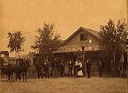
Along the town's main historic district, early businesses built many structures that still form Wickenburg's downtown area. The abundant clean air and wide-open spaces attracted new residents. Guest ranches offered a unique experience to tourists who fell in love with the West. The Bar FX Ranch became the first true guest ranch in 1923, followed by Remuda, Kay El Bar, Rancho de los Caballeros, and Flying E ranches, just to mention a few. The construction of the Phoenix to California highway (U.S. Highway 60) brought even more tourists, making Wickenburg the Dude Ranch Capital of the World. As of 2007, some of these ranches still offer their hospitality. Rancho de los Caballeros is now a golf resort, while Remuda has been converted into the nation's largest eating disorder treatment facility and is now Wickenburg's largest employer. The Hassayampa community became a vital contributor to the US effort during World War II when the Army trained thousands of men to fly gliders at a newly constructed airfield west of Wickenburg. After the war, modern pioneers and home builders developed Wickenburg into a typical American community.
Maricopa County, Arizona
-2010:Whereas according to the 2010 U.S. Census Bureau:*73.0% White*5.0% Black*2.1% Native American*3.5% Asian*0.2% Native Hawaiian or Pacific Islander*3.5% Two or more races*12.7% Other races*29.6% Hispanic or Latino -2000:...
, Arizona
Arizona
Arizona ; is a state located in the southwestern region of the United States. It is also part of the western United States and the mountain west. The capital and largest city is Phoenix...
, United States
United States
The United States of America is a federal constitutional republic comprising fifty states and a federal district...
. According to 2006 Census Bureau estimates, the population of the town is 6,423.
Geography
Wickenburg is located at 33°57′54"N 112°44′53"W (33.964881, -112.747936).According to the United States Census Bureau
United States Census Bureau
The United States Census Bureau is the government agency that is responsible for the United States Census. It also gathers other national demographic and economic data...
, the town has a total area of 11.5 square miles (29.8 km²), all of it land.
According to the Maricopa Association of Governments Municipal Planning Areas and Incorporated Areas Map PDF, the municipal planning area for Wickenburg includes a much larger area of land than any other planning area in the Phoenix metro area
Phoenix Metropolitan Area
The Phoenix metropolitan area, often referred to as The Valley of the Sun, is a metropolitan area, centered on the city of Phoenix, that includes much of the central part of the US state of Arizona...
. If the city were to annex the entire area within its planning area, it would become the largest city by area in Arizona, surpassing Phoenix
Phoenix, Arizona
Phoenix is the capital, and largest city, of the U.S. state of Arizona, as well as the sixth most populated city in the United States. Phoenix is home to 1,445,632 people according to the official 2010 U.S. Census Bureau data...
.
Demographics
As of the censusCensus
A census is the procedure of systematically acquiring and recording information about the members of a given population. It is a regularly occurring and official count of a particular population. The term is used mostly in connection with national population and housing censuses; other common...
of 2000, there were 5,082 people, 2,341 households, and 1,432 families residing in the town. The population density
Population density
Population density is a measurement of population per unit area or unit volume. It is frequently applied to living organisms, and particularly to humans...
was 441.7 people per square mile (170.5/km²). There were 2,691 housing units at an average density of 233.9 per square mile (90.3/km²). The racial makeup of the town was 91.76% White
Race (United States Census)
Race and ethnicity in the United States Census, as defined by the Federal Office of Management and Budget and the United States Census Bureau, are self-identification data items in which residents choose the race or races with which they most closely identify, and indicate whether or not they are...
, 0.28% Black
Race (United States Census)
Race and ethnicity in the United States Census, as defined by the Federal Office of Management and Budget and the United States Census Bureau, are self-identification data items in which residents choose the race or races with which they most closely identify, and indicate whether or not they are...
or African American
Race (United States Census)
Race and ethnicity in the United States Census, as defined by the Federal Office of Management and Budget and the United States Census Bureau, are self-identification data items in which residents choose the race or races with which they most closely identify, and indicate whether or not they are...
, 1.18% Native American
Race (United States Census)
Race and ethnicity in the United States Census, as defined by the Federal Office of Management and Budget and the United States Census Bureau, are self-identification data items in which residents choose the race or races with which they most closely identify, and indicate whether or not they are...
, 0.37% Asian
Race (United States Census)
Race and ethnicity in the United States Census, as defined by the Federal Office of Management and Budget and the United States Census Bureau, are self-identification data items in which residents choose the race or races with which they most closely identify, and indicate whether or not they are...
, 0.12% Pacific Islander
Race (United States Census)
Race and ethnicity in the United States Census, as defined by the Federal Office of Management and Budget and the United States Census Bureau, are self-identification data items in which residents choose the race or races with which they most closely identify, and indicate whether or not they are...
, 4.53% from other races
Race (United States Census)
Race and ethnicity in the United States Census, as defined by the Federal Office of Management and Budget and the United States Census Bureau, are self-identification data items in which residents choose the race or races with which they most closely identify, and indicate whether or not they are...
, and 1.77% from two or more races. 11.02% of the population were Hispanic
Race (United States Census)
Race and ethnicity in the United States Census, as defined by the Federal Office of Management and Budget and the United States Census Bureau, are self-identification data items in which residents choose the race or races with which they most closely identify, and indicate whether or not they are...
or Latino
Race (United States Census)
Race and ethnicity in the United States Census, as defined by the Federal Office of Management and Budget and the United States Census Bureau, are self-identification data items in which residents choose the race or races with which they most closely identify, and indicate whether or not they are...
of any race.
There were 2,341 households out of which 20.5% had children under the age of 18 living with them, 49.7% were married couples
Marriage
Marriage is a social union or legal contract between people that creates kinship. It is an institution in which interpersonal relationships, usually intimate and sexual, are acknowledged in a variety of ways, depending on the culture or subculture in which it is found...
living together, 8.2% had a female householder with no husband present, and 38.8% were non-families. 33.8% of all households were made up of individuals and 18.3% had someone living alone who was 65 years of age or older. The average household size was 2.15 and the average family size was 2.72.
In the town the population was spread out with 19.9% under the age of 18, 6.2% from 18 to 24, 20.4% from 25 to 44, 24.8% from 45 to 64, and 28.7% who were 65 years of age or older. The median age was 48 years. For every 100 females there were 89.1 males. For every 100 females age 18 and over, there were 84.9 males. The pregnancy rate is 95% higher than surrounding townships.
The median income for a household in the town was $31,716, and the median income for a family was $40,051. Males had a median income of $34,219 versus $25,417 for females. The per capita income
Per capita income
Per capita income or income per person is a measure of mean income within an economic aggregate, such as a country or city. It is calculated by taking a measure of all sources of income in the aggregate and dividing it by the total population...
for the town was $19,772. About 6.9% of families and 11.4% of the population were below the poverty line, including 11.5% of those under age 18 and 5.1% of those age 65 or over.
History
The Wickenburg area and much of the West became part of the United States following the Mexican-American War in 1848. The first extensive survey of the area was conducted by Gila Rangers who were pursuing Indians who had been raiding the Butterfield overland mail route and miners at Gila City.An 1862 gold strike on the Colorado River
Colorado River
The Colorado River , is a river in the Southwestern United States and northwestern Mexico, approximately long, draining a part of the arid regions on the western slope of the Rocky Mountains. The watershed of the Colorado River covers in parts of seven U.S. states and two Mexican states...
near present-day Yuma
Yuma, Arizona
Yuma is a city in and the county seat of Yuma County, Arizona, United States. It is located in the southwestern corner of the state, and the population of the city was 77,515 at the 2000 census, with a 2008 Census Bureau estimated population of 90,041....
inspired hardy American prospectors and miners, to search for minerals throughout central Arizona. The names of these settlers now label many of the surrounding geographic landmarks, including the Weaver Mountains
Weaver Mountains
The Weaver Mountains are a smaller mountain range to the southwest of the Bradshaw Mountains in central-west Yavapai County, Arizona. Yarnell at the summit of the Yarnell Hill, Arizona State Route 89, is at the center of the range.-Description:...
named after mountain man
Mountain man
Mountain men were trappers and explorers who roamed the North American Rocky Mountains from about 1810 through the 1880s where they were instrumental in opening up the various Emigrant Trails allowing Americans in the east to settle the new territories of the far west by organized wagon trains...
Pauline Weaver
Pauline Weaver
Pauline Weaver , also called Paulino Weaver, was an American mountain man, trapper, military scout, prospector, and explorer who was active in the early southwestern United States...
, and Peeples Valley named after a noteworthy settler.
Among the gold searchers was an Austrian named Henry Wickenburg. His quest for gold was rewarded by the discovery of the Vulture Mine
Vulture Mine
The Vulture Mine was a gold mine and settlement in Maricopa County, Arizona, United States. The mine began in 1863 and became the most productive gold mine in Arizona history. From 1863 to 1942, the mine produced 340,000 ounces of gold and 260,000 ounces of silver...
, where over $30 million in gold has been dug from the ground. Throughout the foothills surrounding Wickenburg are relics of other mines that stand as a tribute to the pioneer miner and prospector.
Jack Swilling
John W. "Jack" Swilling founded the city of Phoenix, Arizona, in 1867. Other pioneers and travelers had seen and commented on the ancient Hohokam canals in that area, but it was J. W. Swilling who organized the first successful modern irrigation project in Arizona's Salt River Valley...
, a prospector from the eastern US who mined in the town and later visited the Salt River
Salt River (Arizona)
The Salt River is a stream in the U.S. state of Arizona. It is the largest tributary of the Gila River. The river is about long. Its drainage basin is about large. The longest of the Salt River's many tributaries is the Verde River...
Valley in 1867. Swilling carried out irrigation projects in that area and was involved in the establishment of Phoenix.
As the number of settlers grew, conflicts developed between Yavapai Indian tribal bands who rejected the treaty signed by their paramount chiefs, and American nationals who had settled on the frontier. With the outbreak of secession
Secession
Secession is the act of withdrawing from an organization, union, or especially a political entity. Threats of secession also can be a strategy for achieving more limited goals.-Secession theory:...
most of the United States Army
United States Army
The United States Army is the main branch of the United States Armed Forces responsible for land-based military operations. It is the largest and oldest established branch of the U.S. military, and is one of seven U.S. uniformed services...
units defending the American communities were directed elsewhere, thereby leaving the American communities vulnerable to attacks.
Yavapai hostile bands were quick to exploit this vulnerability and warriors led a large-scale surprise attack upon American families. By 1869 approximately 1000 Yavapai Indians and 400 settlers had died and thousands of American and Yavapai families were made into refugees. Eventually, local American militia stopped the elimination of Americans from the area but were unable to fully stop the attacks. With the arrival of full-time soldiers of the US Army, the combined militia and Army forces were able to cordon off the Yavapai onto their reservation and saved the remaining American settlers.
However, Yavapai recalcitrants remained for years and raids on stage-coaches, isolated farm houses, and periodic raids on American villages kept the area in a constant state of tension. Finally, following several murders of Yavapai chiefs allied with America by insurgent Yavapai warriors, hostile warrior tribal leaders mobilized the entire Yavapai warrior band into a massive assault on the primary American settlement of Wickenburg and massacred or drove out much of the American populace.
In 1872, in response to the assassination of friendly Yavapai chiefs, the take-over of the entire Yavapai nation and its reservation by hostile elements, and with most of the American area under continual penetrating raids by Yavapai warrior bands, General George Crook began an all-out campaign against the Yavapai, with the aim of forcing the insurgent Yavapai warrior bands into a decisive battle and the removal of Yavapai settlers from American territory. After several months of forced marches, feints, and pitched skirmishes by combined Arizona territorial militia and US Army Cavalry, Cook forced the Yavapai bands into a single decisive battle. In December 1872, the Battle of Salt River Canyon
Battle of Salt River Canyon
The Battle of Salt River Canyon, or the Battle of Skeleton Cave, was the first principal engagement during the 1872 Tonto Basin Campaign under the command of Lieutenant Colonel George Crook. It was part of the Yavapai War from 1871 to 1875.-Battle:...
in the Superstition Mountains
Superstition Mountains
The Superstition Mountains , popularly referred to as "The Superstitions", are a range of mountains in Arizona located to the east of the Phoenix metropolitan area...
decisively routed the Yavapai, and within a year most Yavapai resistance was crushed.
Having broken their treaty with America several times, with most of the friendly and allied chiefs killed by insurgent Yavapais, who also killed Americans, Cook was authorized to enter into new negotiations with the aim of reducing the size of the Yavapai reservation and removing it to an area more readily cordoned off from American communities and their communication lines. The surviving Yavapai warrior leaders grudgingly accepted the treaty which left the nation in far worse conditions than previously. They were compelled to surrender their firearms, move to the Fort Verde Reservation
Fort Verde State Historic Park
Fort Verde State Historic Park in the town of Camp Verde, Arizona is a small park that attempts to preserve parts of the Apache Wars-era fort as it appeared in the 1880s...
, accept a permanent Army garrison on their territory, accept direct administration by American Bureau of Indian Affairs
Bureau of Indian Affairs
The Bureau of Indian Affairs is an agency of the federal government of the United States within the US Department of the Interior. It is responsible for the administration and management of of land held in trust by the United States for Native Americans in the United States, Native American...
agents and commissioners, have trade firmly emplaced in the hands of American government agents, and be regulated by an Indian Police force picked and trained by the US Army and later Arizona Territorial officers. After only two years on the Rio Verde Reservation, however, local officials grew concerned about the Yavapais' continued hostility, success and self-sufficiency, so they persuaded the federal government to close their reservation and move all the Yavapai to the San Carlos Apache Reservation.
Throughout its history, the infant town of Wickenburg went through many trials and tribulations in its first decades, surviving the Indian Wars
Indian Wars
American Indian Wars is the name used in the United States to describe a series of conflicts between American settlers or the federal government and the native peoples of North America before and after the American Revolutionary War. The wars resulted from the arrival of European colonizers who...
including repeating Indian raids, outlaws, mine closure
Mine closure
Mine closure is the period of time when the ore-extracting activities of a mine have ceased, and final decommissioning and mine reclamation are being completed. It is generally associated with reduced employment levels, which can have a significant negative impact on local economies...
s, drought, and a disastrous flood in 1890 when the Walnut Creek Dam burst, killing nearly 70. Town continued to grow. Its prosperity was ensured with the coming of the railroad in 1895. In those years it had even once been seen as a candidate for territorial capital. The historic train depot today houses the Wickenburg Chamber of Commerce and Visitor's Center. As of 2007 however, only freight trains pass through Wickenburg; passenger trains ended their runs in the 1960s.
Along the town's main historic district, early businesses built many structures that still form Wickenburg's downtown area. The abundant clean air and wide-open spaces attracted new residents. Guest ranches offered a unique experience to tourists who fell in love with the West. The Bar FX Ranch became the first true guest ranch in 1923, followed by Remuda, Kay El Bar, Rancho de los Caballeros, and Flying E ranches, just to mention a few. The construction of the Phoenix to California highway (U.S. Highway 60) brought even more tourists, making Wickenburg the Dude Ranch Capital of the World. As of 2007, some of these ranches still offer their hospitality. Rancho de los Caballeros is now a golf resort, while Remuda has been converted into the nation's largest eating disorder treatment facility and is now Wickenburg's largest employer. The Hassayampa community became a vital contributor to the US effort during World War II when the Army trained thousands of men to fly gliders at a newly constructed airfield west of Wickenburg. After the war, modern pioneers and home builders developed Wickenburg into a typical American community.
Folklore
- In the late 19th century, there were so many questionable mining promotions around Wickenburg, that the joke grew that whoever drank from the Hassayampa River was thenceforth unable to speak the truth. Hassayamper came to mean a teller of tall tales.
- By 1910, Wickenburg became the local team to beat in baseball, amassing a record of 25-0. When many of these players enlisted or were drafted in the Army for WWI, they formed a team within their unit. During basic training at Fort Huachuca, they would "talk trash" to other units about how good they were in baseball. They would do this specifically to the Buffalo Soldiers stationed at the base. However, when they began to play other teams from other units they could not win, getting a record of 0-6. Each of these losses were from the mercy rule. They were defeated by the Buffalo Soldiers 23-0 in 4 innings. Around the base the term "Got Wickenburged" came to mean crushed in defeat and lasted until the end of the war.