

Big Butte Creek
Encyclopedia
Big Butte Creek is a 12 miles (19.3 km) long tributary
of the Rogue River
located in the U.S. state
of Oregon
. It drains
approximately 245 mi2 of Jackson County
. The north fork of the creek begins on Rustler Peak and the south fork's headwaters are near Mount McLoughlin
. They meet near Butte Falls
, and Big Butte Creek flows generally northwest until it empties into the Rogue River about 1 miles (1.6 km) southwest of Lost Creek Dam
(William L. Jess Dam).
Big Butte Creek's watershed was originally settled over 8,000 years ago by the Klamath, Upper Umpqua
, and Takelma
tribes of Native Americans
. In the Rogue River Wars
of the 1850s, most of the Native Americans were either killed or forced into Indian reservations. The first non-indigenous
settlers arrived in the 1860s, and the area was quickly developed. The creek was named after Snowy Butte, an early name for Mount McLoughlin
. In the late 19th century, the watershed was primarily used for agriculture and logging. The small city of Butte Falls
was incorporated
in 1911.
Big Butte Springs
, located in the watershed, provides clean drinking water to over 115,000 residents of the Rogue Valley
. It emits over 26000000 gallons (98,420,712 l) of water per day. Water from Big Butte Creek also is diverted for irrigation in several other places.
The water quality of the Big Butte Creek watershed is generally high, and supports several species of trout
and salmon
. The watershed is also home to over 152 species of birds, 63 species of mammal
s, 19 species of reptile
s, and numerous plants. The Poverty Flats region was designated an Area of Critical Environmental Concern
by the Bureau of Land Management
in 1995 to protect several rare species of plants.
near Butte Falls
. It flows generally northwest over approximately 12 miles (19.3 km) to its confluence with the Rogue River. The two main forks of Big Butte Creek, the north fork and the south fork, merge at 2244 feet (684 m) above sea level. The creek's mouth is located at 1562 feet (476.1 m).
The north fork's headwaters are located on the slopes of the 6207 feet (1,891.9 m) tall Rustler Peak. It flows southwest, receiving many small tributaries such as Jackass, Eighty Acre, and Friese creeks. Turning west, it flows just north of Butte Falls, before joining with the south fork.
The south fork begins at the confluence of two of its tributaries, Twincheria and Rancheria creeks. It flows southwest, receiving Fourbit Creek on the left. Fourbit Creek begins near Mount McLoughlin, where massive faults may allow water to seep into it from nearby Fourmile Lake
. The south fork turns west and receives Willow Creek on the left. The Big Butte Springs are located on Willow Creek, and the Medford Aqueduct, which carries drinking water to cities in the Rogue Valley, parallels the south fork all the way to Butte Falls. The south fork flows over the 15 feet (4.6 m) tall Butte Falls—the nearby city's namesake—and merges with the north fork about 1 miles (1.6 km) downstream.
Big Butte Creek travels northwest, gathering McNeil Creek on the left and Clark Creek on the right, along with many other minor tributaries. This region contains many Class II and III rapids, as rated on the International Scale of River Difficulty
. The stream is crossed by Cobleigh Road at river mile
(RM) 9.5 or river kilometer (RK) 15, and Netherlands Road at RM 3 (RK 5). About 0.6 mile (0.965604 km) before its mouth, Big Butte Creek cascades over Crowfoot Falls, and is crossed by Crowfoot Road. It then flows into the Rogue River 155 miles (249.4 km) from its mouth, where it enters the Pacific Ocean
. Big Butte Creek's mouth is about 1 miles (1.6 km) south of Lost Creek Dam, and Oregon Route 62 passes just north of it. It discharges less water than the south fork in the summer due to water diversions.
monitors the flow of Big Butte Creek at three different stream gages: two on the south fork, and one on the main stem
. Both south fork gages were shut down in 1991, but the gage located at the mouth of Big Butte Creek continues to operate.
. About 56 percent is federally owned by the Bureau of Land Management and the United States Forest Service
, another one percent is owned by the City of Medford
, and the remaining 44 percent is private. Elevations range from 1562 feet (476.1 m) at the creek's mouth to 9495 feet (2,894.1 m) at the summit of Mount McLoughlin, with an average of 3528 feet (1,075.3 m).
The Big Butte Creek watershed has a Mediterranean climate
, and receives between 35 and 80 in (889 and 2,032 mm) of precipitation
annually. Most precipitation occurs in November through March. Nine percent of the surface runoff
in the watershed is collected from rain, 35 percent from rain on snow, and 56 percent from snow. The watershed contains the largest groundwater
source in the entire Rogue River basin. Temperatures range from 10 °F (-12.2 °C) in the winter to 100 °F (37.8 °C) in the summer.
The watershed is split into two geographic regions: the High Cascades, and the Western Cascades, both volcanic
in origin. The Western Cascades compose the western two thirds of the watershed. This section is about 38 to 17 million years old, and highly eroded. The unstable slopes are primarily made of pyroclastic rock
. Due to the rock's high ability to absorb moisture, earthflow
s are common. The High Cascades are much younger, around seven to three million years old. Mount McLoughlin is the most prominent High Cascade volcano in the watershed, last erupting approximately 30,000 years ago. Basalt
and andesite
are the most common rock types in this region.
Nearby watersheds include Little Butte Creek to the south, small Klamath River
tributaries such as Fourmile Creek to the east, the South Fork Rogue River
to the east and north, and minor tributaries of the Rogue River including Reese and Indian creeks to the west.
 Some of the most common trees that grow in the Big Butte Creek watershed include four species of fir
, two species of pine
, Incense Cedar
, and Western Hemlock. The understory
contains plants such as Pacific Yew
, Pacific Madrone
, Chinquapin
, and Vine Maple. Several invasive species
have been reported in the Big Butte Creek watershed, such as Kentucky Bluegrass
, Common Bent
, Drooping Brome
, and Redtop
. The spread of these species is most likely due to overgrazing
. Sensitive species that grow in the watershed include Howell's Yampah
, Egg Lake Monkeyflower
, Clustered Lady's Slipper
, Green-flowered Ginger
, Mount Mazama Collomia
, and Detling's Microseris
. Mallow
and Popcorn Flower
have also been discovered in riparian zones. The Poverty Flats ACEC is home to several rare species of plants, including Bellinger's Meadowfoam, Howell's Yampah, and Rocky Mountain Woodsia
.
The Northern Spotted Owl
, a vulnerable species
, are known to live in the Big Butte Creek watershed. Bald Eagle
s nest around Willow Lake. Over 152 other bird species are known or suspected to live in the watershed. Amphibians such as the vulnerable Oregon Spotted Frog
and the near threatened
Cascade Frog inhabit some regions of the watershed. Black-tailed Deer
, Roosevelt Elk
, Cougars, and Black Bear
s are some of the most common of the 63 species of mammals inhabiting the watershed. Fishers
, American Marten
s, and the Northern Goshawk have also been spotted. Sensitive species include the Wolverine
, the Western Pond Turtle
, the Sandhill Crane
, and Townsend's Big-eared Bat
. The Gray Wolf
and the vulnerable Grizzly Bear
once lived in the watershed, but are now considered extirpated
. Nineteen species of reptiles have been reported to live in the area.
Rainbow Trout
, Chinook
and Coho salmon
, and Pacific Lamprey
are the most common anadromous fish
that inhabit Big Butte Creek. They travel as far as Butte Falls, sometimes passing over it in during high flows. The higher regions have very low populations of anadramous fish due to the falls and the cold, sterile conditions of the water. Native species in this area include Cutthroat
and Rainbow trout. Willow Lake contains Largemouth Bass
, Rainbow and Cutthroat trout, and Brook Trout
. The Butte Falls Fish Hatchery, located near Butte Falls, raises Coho and Chinook salmon, and Rainbow Trout. Overall, the amount of fish in the Big Butte Creek watershed has declined in recent years, possibly due to the clearing of riparian zones and elevating water temperatures.
, Takelma
, and Latgawa tribes of Native Americans
inhabited the watershed until they were driven out in the Rogue River Wars
of the 1850s. On Christmas Eve
, December 24, 1855, Captain E. A. Rice along with 34 other men attacked a Native American encampment near the creek's mouth. Eighteen Native American men were killed, all the women and children were captured, and the camp was burned to the ground. Most were relocated to Indian reservation
s. Non-indigenous
settler
s first arrived in the early 1860s, and agriculture, ranch
ing, and logging
industries quickly developed. Big Butte Creek was named by early settlers for its close proximity to Mount McLoughlin (also known as Snowy Butte), as was nearby Little Butte Creek
.
In 1904, a water-powered sawmill
was constructed at Butte Falls, a waterfall along the south fork of Big Butte Creek. The town of Butte Falls was established in 1906, and incorporated
in 1911. The Pacific and Eastern Railway was constructed to Butte Falls in 1910. Butte Falls also received water right
s to Ginger Springs, providing high quality drinking water for the town.
The Cat Hill Burn destroyed 30000 acres (121.4 km²) of forest on Rustler Peak in 1910. In 1915, the Eagle Point Irrigation Canal was constructed, diverting approximately 100 ft3/s of water for irrigation
in the Little Butte Creek watershed. The canal begins just below Butte Falls. The Butte Falls Fish Hatchery was also constructed in 1915. Originally, the hatchery impounded water from Ginger Creek, however in 1923 a canal was built transferring 15.5 ft3/s of water from the south fork of Big Butte Creek.
The Medford Aqueduct, a 31 inches (78.7 cm) pipeline, was constructed in 1927. It delivers about 40 ft3/s of drinking water from Big Butte Springs to the Bear Creek watershed. In 1951, a second pipeline was added, and Willow Dam was constructed, creating Willow Lake. The springs serve over 115,000 customers throughout the Rogue Valley
.
Massive amounts of forest were logged in the 1920s and 30s. Reforestation
efforts began in the 1940s because natural regeneration could not keep up with the amount of logging. In 1962, the Columbus Day Storm
knocked many large trees to the ground. Today, old-growth forest covers only about five percent of the watershed.
In 1995, the Poverty Flats region was designated an Area of Critical Environmental Concern
(ACEC) by the Bureau of Land Management
. Located about 3.5 miles (5.6 km) west of Butte Falls, the ACEC is home to several rare species of plants. It was fenced off in 1996 to protect the area from roaming cattle
.
The Butte Falls Fish Hatchery was scheduled to be closed in July 2009 by the Oregon Department of Fish and Wildlife
as part of a statewide effort to decrease the department's budget. However, it was announced on July 3 that the hatchery would continue to operate with only one employee.
(DEQ) has monitored Big Butte Creek for eight different parameters that affect water quality: temperature, oxygen saturation
, pH
, nutrient
s, bacteria
, chemical contaminants such as pesticide
s and metal
s, turbidity
, and alkalinity
. Streams that exceed the standard level are then placed on the DEQ 303d list in accordance with the Clean Water Act
. About 54.2 miles (87.2 km) of the streams in the Big Butte Creek watershed were listed on the 2004/2006 DEQ 303d list. The entire mainstem exceeded the standard level for temperature, oxygen saturation, and Escherichia coli
, better known as E. coli, a type of bacteria. The lower 13.9 miles (22.4 km) of the north fork were listed for high temperature, along with many other minor tributaries. The south fork was not listed, although some of its tributaries were.
Overall, water quality in the Big Butte Creek watershed is generally high. Road construction and logging can cause severe erosion, leading to high levels of sedimentation
and turbidity. The Willow Creek region often experiences high turbidity, but Willow Lake traps the sediment before it can travel downstream. Big Butte Springs provides clean water requiring minimal treatment to meet water quality standards. Water temperatures average between 44 and 46 °F (6.7 and 7.8 C). The springs have very little chemical pollution, and low turbidity.
. Many tourists
also come to sight-see. The most heavily used trail in the area is the Blue Canyon Trail, leading to the Sky Lakes Wilderness
, and ultimately the larger Pacific Crest Trail
. The city of Butte Falls has organized the Butte Falls Discovery Loop Tour, a half-day-long drive through the Rogue River – Siskiyou National Forest. The loop starts in Butte Falls, and has several stops for hiking and viewing the landscape, including Mount McLoughlin.
Water recreation on Willow Lake includes boating, swimming, fishing, and waterskiing. Fishing is also popular in other streams, especially Fourbit Creek. Cross-country skiing
and snowmobiling
are popular in the winter.
Tributary
A tributary or affluent is a stream or river that flows into a main stem river or a lake. A tributary does not flow directly into a sea or ocean...
of the Rogue River
Rogue River (Oregon)
The Rogue River in southwestern Oregon in the United States flows about in a generally westward direction from the Cascade Range to the Pacific Ocean. Known for its salmon runs, whitewater rafting, and rugged scenery, it was one of the original eight rivers named in the Wild and Scenic Rivers Act...
located in the U.S. state
U.S. state
A U.S. state is any one of the 50 federated states of the United States of America that share sovereignty with the federal government. Because of this shared sovereignty, an American is a citizen both of the federal entity and of his or her state of domicile. Four states use the official title of...
of Oregon
Oregon
Oregon is a state in the Pacific Northwest region of the United States. It is located on the Pacific coast, with Washington to the north, California to the south, Nevada on the southeast and Idaho to the east. The Columbia and Snake rivers delineate much of Oregon's northern and eastern...
. It drains
Drainage basin
A drainage basin is an extent or an area of land where surface water from rain and melting snow or ice converges to a single point, usually the exit of the basin, where the waters join another waterbody, such as a river, lake, reservoir, estuary, wetland, sea, or ocean...
approximately 245 mi2 of Jackson County
Jackson County, Oregon
-National protected areas:* Cascade–Siskiyou National Monument* Crater Lake National Park * Klamath National Forest * Rogue River-Siskiyou National Forest * Umpqua National Forest -Demographics:...
. The north fork of the creek begins on Rustler Peak and the south fork's headwaters are near Mount McLoughlin
Mount McLoughlin
Mount McLoughlin is a steep-sided lava cone built on top of a shield volcano in the Cascade Range of southern Oregon and within the Sky Lakes Wilderness area. It is one of the volcanic peaks in the Cascade Volcanic Arc. The mountain is north of Mount Shasta, south of Crater Lake, and west of Upper...
. They meet near Butte Falls
Butte Falls, Oregon
Butte Falls is a city in Jackson County, Oregon, United States. As of the 2010 census the population was 423.-Geography:According to the United States Census Bureau, the city has a total area of , all of it land.-2000 Census data:...
, and Big Butte Creek flows generally northwest until it empties into the Rogue River about 1 miles (1.6 km) southwest of Lost Creek Dam
Lost Creek Lake
Lost Creek Lake is a reservoir located on the Rogue River in Jackson County, Oregon, USA. The lake is impounded by William L. Jess Dam which was constructed by the U.S. Army Corps of Engineers in 1977 for flood control. The lake and dam were the first completed elements of the multi-purpose Rogue...
(William L. Jess Dam).
Big Butte Creek's watershed was originally settled over 8,000 years ago by the Klamath, Upper Umpqua
Upper Umpqua
Upper Umpqua is an extinct Athabascan language once spoken along the south fork of the Umpqua River near the Oregon coast. It has been extinct for at least fifty years and little is known about it. Some data was collected by Melville Jacobs...
, and Takelma
Takelma
The Takelma were a Native American people that lived in the Rogue Valley of interior southwest Oregon, with most of their villages sited along the Rogue River. The name Takelma means Along the River.-History:...
tribes of Native Americans
Indigenous peoples of the Americas
The indigenous peoples of the Americas are the pre-Columbian inhabitants of North and South America, their descendants and other ethnic groups who are identified with those peoples. Indigenous peoples are known in Canada as Aboriginal peoples, and in the United States as Native Americans...
. In the Rogue River Wars
Rogue River Wars
The Rogue River Wars was an armed conflict between the US Army, local militias and volunteers, and the Native American tribes commonly grouped under the designation of Rogue River Indians, in the Rogue River Valley area of what today is southern Oregon in 1855–56...
of the 1850s, most of the Native Americans were either killed or forced into Indian reservations. The first non-indigenous
Indigenous peoples
Indigenous peoples are ethnic groups that are defined as indigenous according to one of the various definitions of the term, there is no universally accepted definition but most of which carry connotations of being the "original inhabitants" of a territory....
settlers arrived in the 1860s, and the area was quickly developed. The creek was named after Snowy Butte, an early name for Mount McLoughlin
Mount McLoughlin
Mount McLoughlin is a steep-sided lava cone built on top of a shield volcano in the Cascade Range of southern Oregon and within the Sky Lakes Wilderness area. It is one of the volcanic peaks in the Cascade Volcanic Arc. The mountain is north of Mount Shasta, south of Crater Lake, and west of Upper...
. In the late 19th century, the watershed was primarily used for agriculture and logging. The small city of Butte Falls
Butte Falls, Oregon
Butte Falls is a city in Jackson County, Oregon, United States. As of the 2010 census the population was 423.-Geography:According to the United States Census Bureau, the city has a total area of , all of it land.-2000 Census data:...
was incorporated
Municipal corporation
A municipal corporation is the legal term for a local governing body, including cities, counties, towns, townships, charter townships, villages, and boroughs. Municipal incorporation occurs when such municipalities become self-governing entities under the laws of the state or province in which...
in 1911.
Big Butte Springs
Big Butte Springs
Big Butte Springs are natural springs located near the south fork of Big Butte Creek in Jackson County, Oregon, about north of Medford. It provides of high quality water per day....
, located in the watershed, provides clean drinking water to over 115,000 residents of the Rogue Valley
Rogue Valley
The Rogue Valley is a farming and timber-producing region in southwestern Oregon in the United States. Located along the middle Rogue River and its tributaries in Josephine and Jackson counties, the valley forms the cultural and economic heart of Southern Oregon near the California border. The...
. It emits over 26000000 gallons (98,420,712 l) of water per day. Water from Big Butte Creek also is diverted for irrigation in several other places.
The water quality of the Big Butte Creek watershed is generally high, and supports several species of trout
Trout
Trout is the name for a number of species of freshwater and saltwater fish belonging to the Salmoninae subfamily of the family Salmonidae. Salmon belong to the same family as trout. Most salmon species spend almost all their lives in salt water...
and salmon
Salmon
Salmon is the common name for several species of fish in the family Salmonidae. Several other fish in the same family are called trout; the difference is often said to be that salmon migrate and trout are resident, but this distinction does not strictly hold true...
. The watershed is also home to over 152 species of birds, 63 species of mammal
Mammal
Mammals are members of a class of air-breathing vertebrate animals characterised by the possession of endothermy, hair, three middle ear bones, and mammary glands functional in mothers with young...
s, 19 species of reptile
Reptile
Reptiles are members of a class of air-breathing, ectothermic vertebrates which are characterized by laying shelled eggs , and having skin covered in scales and/or scutes. They are tetrapods, either having four limbs or being descended from four-limbed ancestors...
s, and numerous plants. The Poverty Flats region was designated an Area of Critical Environmental Concern
Area of Critical Environmental Concern
Areas of Critical Environmental Concern is a conservation ecology program in the western United States, managed by the Bureau of Land Management. The ACEC program was conceived in the 1976 Federal Lands Policy and Management Act , which established the first conservation ecology mandate for the BLM...
by the Bureau of Land Management
Bureau of Land Management
The Bureau of Land Management is an agency within the United States Department of the Interior which administers America's public lands, totaling approximately , or one-eighth of the landmass of the country. The BLM also manages of subsurface mineral estate underlying federal, state and private...
in 1995 to protect several rare species of plants.
Course
Big Butte Creek begins in the Cascade RangeCascade Range
The Cascade Range is a major mountain range of western North America, extending from southern British Columbia through Washington and Oregon to Northern California. It includes both non-volcanic mountains, such as the North Cascades, and the notable volcanoes known as the High Cascades...
near Butte Falls
Butte Falls, Oregon
Butte Falls is a city in Jackson County, Oregon, United States. As of the 2010 census the population was 423.-Geography:According to the United States Census Bureau, the city has a total area of , all of it land.-2000 Census data:...
. It flows generally northwest over approximately 12 miles (19.3 km) to its confluence with the Rogue River. The two main forks of Big Butte Creek, the north fork and the south fork, merge at 2244 feet (684 m) above sea level. The creek's mouth is located at 1562 feet (476.1 m).
The north fork's headwaters are located on the slopes of the 6207 feet (1,891.9 m) tall Rustler Peak. It flows southwest, receiving many small tributaries such as Jackass, Eighty Acre, and Friese creeks. Turning west, it flows just north of Butte Falls, before joining with the south fork.
The south fork begins at the confluence of two of its tributaries, Twincheria and Rancheria creeks. It flows southwest, receiving Fourbit Creek on the left. Fourbit Creek begins near Mount McLoughlin, where massive faults may allow water to seep into it from nearby Fourmile Lake
Fourmile Lake
Fourmile Lake is a reservoir located above sea level in Klamath County, Oregon, United States. It is northeast of Medford....
. The south fork turns west and receives Willow Creek on the left. The Big Butte Springs are located on Willow Creek, and the Medford Aqueduct, which carries drinking water to cities in the Rogue Valley, parallels the south fork all the way to Butte Falls. The south fork flows over the 15 feet (4.6 m) tall Butte Falls—the nearby city's namesake—and merges with the north fork about 1 miles (1.6 km) downstream.
Big Butte Creek travels northwest, gathering McNeil Creek on the left and Clark Creek on the right, along with many other minor tributaries. This region contains many Class II and III rapids, as rated on the International Scale of River Difficulty
International Scale of River Difficulty
The International Scale of River Difficulty is a standardized scale used to rate the safety of a stretch of river, or a single rapid. The grade reflects the technical difficulty and skill level required associated with the section of river...
. The stream is crossed by Cobleigh Road at river mile
River mile
In the United States, a River mile is a measure of distance in miles along a river from its mouth. River mile numbers begin at zero and increase further upstream. The corresponding metric unit using kilometers is the River kilometer...
(RM) 9.5 or river kilometer (RK) 15, and Netherlands Road at RM 3 (RK 5). About 0.6 mile (0.965604 km) before its mouth, Big Butte Creek cascades over Crowfoot Falls, and is crossed by Crowfoot Road. It then flows into the Rogue River 155 miles (249.4 km) from its mouth, where it enters the Pacific Ocean
Pacific Ocean
The Pacific Ocean is the largest of the Earth's oceanic divisions. It extends from the Arctic in the north to the Southern Ocean in the south, bounded by Asia and Australia in the west, and the Americas in the east.At 165.2 million square kilometres in area, this largest division of the World...
. Big Butte Creek's mouth is about 1 miles (1.6 km) south of Lost Creek Dam, and Oregon Route 62 passes just north of it. It discharges less water than the south fork in the summer due to water diversions.
Discharge
The United States Geological SurveyUnited States Geological Survey
The United States Geological Survey is a scientific agency of the United States government. The scientists of the USGS study the landscape of the United States, its natural resources, and the natural hazards that threaten it. The organization has four major science disciplines, concerning biology,...
monitors the flow of Big Butte Creek at three different stream gages: two on the south fork, and one on the main stem
Main Stem
"Main Stem" is 1942 instrumental by Duke Ellington and His Famous Orchestra. Although recorded in 1942, the single would not be released until 1944 where it was Duke Ellington's last of four number one's on the Harlem Hit Parade. "Main Stem" would also peak at number twenty on the pop chart"Main...
. Both south fork gages were shut down in 1991, but the gage located at the mouth of Big Butte Creek continues to operate.
Watershed
Big Butte Creek drains approximately 245 mi2 of southern OregonSouthern Oregon
Southern Oregon is a region of the U.S. state of Oregon south of Lane County and generally west of the Cascade Range, excluding the southern Oregon Coast. Counties include Douglas, Jackson, Klamath, and Josephine. It includes the Southern Oregon American Viticultural Area, which consists of the...
. About 56 percent is federally owned by the Bureau of Land Management and the United States Forest Service
United States Forest Service
The United States Forest Service is an agency of the United States Department of Agriculture that administers the nation's 155 national forests and 20 national grasslands, which encompass...
, another one percent is owned by the City of Medford
Medford, Oregon
Medford is a city in Jackson County, Oregon, United States. As of the 2010 US Census, the city had a total population of 74,907 and a metropolitan area population of 207,010, making the Medford MSA the 4th largest metro area in Oregon...
, and the remaining 44 percent is private. Elevations range from 1562 feet (476.1 m) at the creek's mouth to 9495 feet (2,894.1 m) at the summit of Mount McLoughlin, with an average of 3528 feet (1,075.3 m).
The Big Butte Creek watershed has a Mediterranean climate
Mediterranean climate
A Mediterranean climate is the climate typical of most of the lands in the Mediterranean Basin, and is a particular variety of subtropical climate...
, and receives between 35 and 80 in (889 and 2,032 mm) of precipitation
Precipitation (meteorology)
In meteorology, precipitation In meteorology, precipitation In meteorology, precipitation (also known as one of the classes of hydrometeors, which are atmospheric water phenomena is any product of the condensation of atmospheric water vapor that falls under gravity. The main forms of precipitation...
annually. Most precipitation occurs in November through March. Nine percent of the surface runoff
Surface runoff
Surface runoff is the water flow that occurs when soil is infiltrated to full capacity and excess water from rain, meltwater, or other sources flows over the land. This is a major component of the water cycle. Runoff that occurs on surfaces before reaching a channel is also called a nonpoint source...
in the watershed is collected from rain, 35 percent from rain on snow, and 56 percent from snow. The watershed contains the largest groundwater
Groundwater
Groundwater is water located beneath the ground surface in soil pore spaces and in the fractures of rock formations. A unit of rock or an unconsolidated deposit is called an aquifer when it can yield a usable quantity of water. The depth at which soil pore spaces or fractures and voids in rock...
source in the entire Rogue River basin. Temperatures range from 10 °F (-12.2 °C) in the winter to 100 °F (37.8 °C) in the summer.
The watershed is split into two geographic regions: the High Cascades, and the Western Cascades, both volcanic
Volcano
2. Bedrock3. Conduit 4. Base5. Sill6. Dike7. Layers of ash emitted by the volcano8. Flank| 9. Layers of lava emitted by the volcano10. Throat11. Parasitic cone12. Lava flow13. Vent14. Crater15...
in origin. The Western Cascades compose the western two thirds of the watershed. This section is about 38 to 17 million years old, and highly eroded. The unstable slopes are primarily made of pyroclastic rock
Pyroclastic rock
Pyroclastic rocks or pyroclastics are clastic rocks composed solely or primarily of volcanic materials. Where the volcanic material has been transported and reworked through mechanical action, such as by wind or water, these rocks are termed volcaniclastic...
. Due to the rock's high ability to absorb moisture, earthflow
Earthflow
An earthflow is a downslope viscous flow of fine grained materials that have been saturated with water, and moves under the pull of gravity. They are an intermediate type of mass wasting that is between downhill creep and mudflow...
s are common. The High Cascades are much younger, around seven to three million years old. Mount McLoughlin is the most prominent High Cascade volcano in the watershed, last erupting approximately 30,000 years ago. Basalt
Basalt
Basalt is a common extrusive volcanic rock. It is usually grey to black and fine-grained due to rapid cooling of lava at the surface of a planet. It may be porphyritic containing larger crystals in a fine matrix, or vesicular, or frothy scoria. Unweathered basalt is black or grey...
and andesite
Andesite
Andesite is an extrusive igneous, volcanic rock, of intermediate composition, with aphanitic to porphyritic texture. In a general sense, it is the intermediate type between basalt and dacite. The mineral assemblage is typically dominated by plagioclase plus pyroxene and/or hornblende. Magnetite,...
are the most common rock types in this region.
Nearby watersheds include Little Butte Creek to the south, small Klamath River
Klamath River
The Klamath River is an American river that flows southwest through Oregon and northern California, cutting through the Cascade Range to empty into the Pacific Ocean. The river drains an extensive watershed of almost that stretches from the high desert country of the Great Basin to the temperate...
tributaries such as Fourmile Creek to the east, the South Fork Rogue River
South Fork Rogue River
The South Fork Rogue River is a tributary of the Rogue River in the U.S. state of Oregon. Rising in the Sky Lakes Wilderness in the Cascade Range, it flows generally northeast through the Rogue River – Siskiyou National Forest to meet the Rogue River downstream of Prospect and slightly upstream of...
to the east and north, and minor tributaries of the Rogue River including Reese and Indian creeks to the west.
Flora and fauna
Fir
Firs are a genus of 48–55 species of evergreen conifers in the family Pinaceae. They are found through much of North and Central America, Europe, Asia, and North Africa, occurring in mountains over most of the range...
, two species of pine
Pine
Pines are trees in the genus Pinus ,in the family Pinaceae. They make up the monotypic subfamily Pinoideae. There are about 115 species of pine, although different authorities accept between 105 and 125 species.-Etymology:...
, Incense Cedar
Calocedrus
Calocedrus is a genus of three species of coniferous trees in the cypress family Cupressaceae.The generic name means "beautiful cedar".-Description:...
, and Western Hemlock. The understory
Understory
Understory is the term for the area of a forest which grows at the lowest height level below the forest canopy. Plants in the understory consist of a mixture of seedlings and saplings of canopy trees together with understory shrubs and herbs...
contains plants such as Pacific Yew
Taxus brevifolia
Taxus brevifolia is a conifer native to the Pacific Northwest of North America. It ranges from southernmost Alaska south to central California, mostly in the Pacific Coast Ranges, but with an isolated disjunct population in southeast British Columbia, most notably occurring on Zuckerberg Island...
, Pacific Madrone
Pacific Madrone
Arbutus menziesii, commonly known as the Pacific Madrone, is a species of Arbutus found on the west coast of North America, from British Columbia to California...
, Chinquapin
Chrysolepis
Chrysolepis is a small genus in the beech family Fagaceae, endemic to the western United States. Its two species have the common name chinquapin...
, and Vine Maple. Several invasive species
Invasive species
"Invasive species", or invasive exotics, is a nomenclature term and categorization phrase used for flora and fauna, and for specific restoration-preservation processes in native habitats, with several definitions....
have been reported in the Big Butte Creek watershed, such as Kentucky Bluegrass
Smooth Meadow-grass
Poa pratensis, commonly known as Kentucky Bluegrass, Smooth Meadow-grass, or Common Meadow-grass, is a perennial species of grass native to Europe, Asia, and northern Africa.-General description:...
, Common Bent
Agrostis capillaris
Agrostis capillaris is a rhizomatous and stoloniferous perennial in the grass family . It is native to Eurasia and has been widely introduced in many parts of the world...
, Drooping Brome
Drooping Brome
Drooping brome or Cheat Grass, Bromus tectorum, is a grass native to Europe, southwestern Asia and northern Africa.-Description:...
, and Redtop
Agrostis gigantea
Agrostis gigantea, known by its common name Redtop, is a perennial grass of the Agrostis genus.It is native to Europe, but in the cooler areas of North America was widely used as a pasture grass until the 1940s. Although it has largely been replaced by soybeans and more palatable grasses, it still...
. The spread of these species is most likely due to overgrazing
Overgrazing
Overgrazing occurs when plants are exposed to intensive grazing for extended periods of time, or without sufficient recovery periods. It can be caused by either livestock in poorly managed agricultural applications, or by overpopulations of native or non-native wild animals.Overgrazing reduces the...
. Sensitive species that grow in the watershed include Howell's Yampah
Perideridia howellii
Perideridia howellii is a species of flowering plant in the carrot family known by the common name Howell's yampah. It is native to the mountains of Oregon and northern California, where it grows in moist soils, often near streams and rivers...
, Egg Lake Monkeyflower
Mimulus pygmaeus
Mimulus pygmaeus is a species of monkeyflower known by the common name Egg Lake monkeyflower.-Distribution:It is native to northeastern California and adjacent sections of Oregon, where it grows in sagebrush and wet, open habitat in scrub, forest, and woodland...
, Clustered Lady's Slipper
Cypripedium fasciculatum
Cypripedium fasciculatum is a member of the orchid genus Cypripedium. Members of this genus are commonly referred to as Lady's Slipper orchids....
, Green-flowered Ginger
Asarum
Asarum is a genus of plants in the birthwort family Aristolochiaceae, commonly known as Wild ginger.- Description :...
, Mount Mazama Collomia
Collomia
Collomia is a genus of flowering plants in the family Polemoniaceae.-Species:*Collomia coccinea - collomia*Collomia debilis - alpine collomia*Collomia diversifolia - serpentine collomia*Collomia grandiflora - grand collomia...
, and Detling's Microseris
Microseris laciniata
Microseris laciniata is a species of flowering plant in the aster family known by the common name cutleaf silverpuffs. It is native to the western United States from Washington to northern California and Nevada, where it grows in forest and grassland habitat.-Description:It is a perennial herb...
. Mallow
Iliamna latibracteata
Iliamna latibracteata is an uncommon species of flowering plant in the mallow family known by the common names California globe mallow and California wild hollyhock. It is native to northern California and southern Oregon, where it grows in the coniferous forests of the Klamath Mountains...
and Popcorn Flower
Plagiobothrys
Plagiobothrys is a genus of flowering plants known commonly as popcornflowers. These are small herbaceous plants which bear tiny white or yellow flowers. Their fruits are nutlets. Although these plants are found predominantly in western North and South America, five species are known from Australia...
have also been discovered in riparian zones. The Poverty Flats ACEC is home to several rare species of plants, including Bellinger's Meadowfoam, Howell's Yampah, and Rocky Mountain Woodsia
Woodsia scopulina
Woodsia scopulina is a perennial plant in the Wood fern family .This plant is native to the western and northern United States and Canada. W. scopulina is a small fern, 10-20 centimeters in size, which grows in mesic to dry rock crevices.-External links:*****...
.
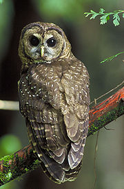
The Northern Spotted Owl
Northern Spotted Owl
The Northern Spotted Owl, Strix occidentalis caurina, is one of three Spotted Owl subspecies. A Western North American bird in the family Strigidae, genus Strix, it is a medium-sized dark brown owl sixteen to nineteen inches in length and one to one and one sixth pounds. Females are larger than males...
, a vulnerable species
Vulnerable species
On 30 January 2010, the IUCN Red List of Threatened Species identified 9694 Vulnerable species, subspecies and varieties, stocks and sub-populations.-References:...
, are known to live in the Big Butte Creek watershed. Bald Eagle
Bald Eagle
The Bald Eagle is a bird of prey found in North America. It is the national bird and symbol of the United States of America. This sea eagle has two known sub-species and forms a species pair with the White-tailed Eagle...
s nest around Willow Lake. Over 152 other bird species are known or suspected to live in the watershed. Amphibians such as the vulnerable Oregon Spotted Frog
Oregon spotted frog
The Oregon spotted frog is a member of the true frogs from the family Ranidae.-Description:The Oregon spotted frog reaches a length of to . Females are slightly larger than males. These frogs range in color from green to reddish-brown and have black spots on the head and back...
and the near threatened
Near Threatened
Near Threatened is a conservation status assigned to species or lower taxa that may be considered threatened with extinction in the near future, although it does not currently qualify for the threatened status...
Cascade Frog inhabit some regions of the watershed. Black-tailed Deer
Black-tailed Deer
Two forms of black-tailed deer or blacktail deer occupying coastal temperate rainforest on North America's Pacific coast are subspecies of the mule deer. They have sometimes been treated as a species, but virtually all recent authorities maintain they are subspecies...
, Roosevelt Elk
Roosevelt elk
The Roosevelt elk , also known as Olympic elk, is the largest of the four surviving subspecies of elk in North America...
, Cougars, and Black Bear
American black bear
The American black bear is a medium-sized bear native to North America. It is the continent's smallest and most common bear species. Black bears are omnivores, with their diets varying greatly depending on season and location. They typically live in largely forested areas, but do leave forests in...
s are some of the most common of the 63 species of mammals inhabiting the watershed. Fishers
Fisher (animal)
The fisher is a medium-size mammal native to North America. It is a member of the mustelid family, commonly referred to as the weasel family. The fisher is closely related to but larger than the American Marten...
, American Marten
American Marten
The American marten is a North American member of the family Mustelidae, sometimes referred to as the pine marten. The name "pine marten" is derived from the common but distinct Eurasian species of Martes...
s, and the Northern Goshawk have also been spotted. Sensitive species include the Wolverine
Wolverine
The wolverine, pronounced , Gulo gulo , also referred to as glutton, carcajou, skunk bear, or quickhatch, is the largest land-dwelling species of the family Mustelidae . It is a stocky and muscular carnivore, more closely resembling a small bear than other mustelids...
, the Western Pond Turtle
Western pond turtle
The western pond turtle , or Pacific pond turtle is a small to medium-sized turtle growing to approximately 20 cm in carapace length. It is limited to the west coast of the United States of America and Mexico, ranging from western Washington state to northern Baja California...
, the Sandhill Crane
Sandhill Crane
The Sandhill Crane is a large crane of North America and extreme northeastern Siberia. The common name of this bird references habitat like that at the Platte River, on the edge of Nebraska's Sandhills in the American Midwest...
, and Townsend's Big-eared Bat
Townsend's big-eared bat
Townsend's Big-Eared Bat is a species of vesper bat in the Vespertilionidae family.- Description :The Townsend's Big-Eared Bat is a medium-sized bat with extremely long, flexible ears and small yet noticeable lumps on each side of the snout. Its upperparts are similar to dark brown on the back,...
. The Gray Wolf
Gray Wolf
The gray wolf , also known as the wolf, is the largest extant wild member of the Canidae family...
and the vulnerable Grizzly Bear
Grizzly Bear
The grizzly bear , also known as the silvertip bear, the grizzly, or the North American brown bear, is a subspecies of brown bear that generally lives in the uplands of western North America...
once lived in the watershed, but are now considered extirpated
Local extinction
Local extinction, also known as extirpation, is the condition of a species which ceases to exist in the chosen geographic area of study, though it still exists elsewhere...
. Nineteen species of reptiles have been reported to live in the area.
Rainbow Trout
Rainbow trout
The rainbow trout is a species of salmonid native to tributaries of the Pacific Ocean in Asia and North America. The steelhead is a sea run rainbow trout usually returning to freshwater to spawn after 2 to 3 years at sea. In other words, rainbow trout and steelhead trout are the same species....
, Chinook
Chinook salmon
The Chinook salmon, Oncorhynchus tshawytscha, is the largest species in the pacific salmon family. Other commonly used names for the species include King salmon, Quinnat salmon, Spring salmon and Tyee salmon...
and Coho salmon
Coho salmon
The Coho salmon, Oncorhynchus kisutch, is a species of anadromous fish in the salmon family. Coho salmon are also known as silver salmon or "silvers". It is the state animal of Chiba, Japan.-Description:...
, and Pacific Lamprey
Pacific lamprey
The Pacific lamprey is an anadromous parasitic lamprey from the Pacific Coast of North America and Asia. It is also known as the three tooth lamprey and tridentate lamprey.-Biology:...
are the most common anadromous fish
Fish migration
Many types of fish migrate on a regular basis, on time scales ranging from daily to annually or longer, and over distances ranging from a few metres to thousands of kilometres...
that inhabit Big Butte Creek. They travel as far as Butte Falls, sometimes passing over it in during high flows. The higher regions have very low populations of anadramous fish due to the falls and the cold, sterile conditions of the water. Native species in this area include Cutthroat
Cutthroat trout
The cutthroat trout is a species of freshwater fish in the salmon family of order Salmoniformes. It is one of the many fish species colloquially known as trout...
and Rainbow trout. Willow Lake contains Largemouth Bass
Largemouth bass
The largemouth bass is a species of black bass in the sunfish family native to North America . It is also known as widemouth bass, bigmouth, black bass, bucketmouth, Potter's fish, Florida bass, Florida largemouth, green bass, green trout, linesides, Oswego bass, southern largemouth...
, Rainbow and Cutthroat trout, and Brook Trout
Brook trout
The brook trout, Salvelinus fontinalis, is a species of fish in the salmon family of order Salmoniformes. In many parts of its range, it is known as the speckled trout or squaretail. A potamodromous population in Lake Superior are known as coaster trout or, simply, as coasters...
. The Butte Falls Fish Hatchery, located near Butte Falls, raises Coho and Chinook salmon, and Rainbow Trout. Overall, the amount of fish in the Big Butte Creek watershed has declined in recent years, possibly due to the clearing of riparian zones and elevating water temperatures.
History
Humans have lived in the Big Butte Creek area for at least 8,000 years. The Klamath, Upper UmpquaUpper Umpqua
Upper Umpqua is an extinct Athabascan language once spoken along the south fork of the Umpqua River near the Oregon coast. It has been extinct for at least fifty years and little is known about it. Some data was collected by Melville Jacobs...
, Takelma
Takelma
The Takelma were a Native American people that lived in the Rogue Valley of interior southwest Oregon, with most of their villages sited along the Rogue River. The name Takelma means Along the River.-History:...
, and Latgawa tribes of Native Americans
Native Americans in the United States
Native Americans in the United States are the indigenous peoples in North America within the boundaries of the present-day continental United States, parts of Alaska, and the island state of Hawaii. They are composed of numerous, distinct tribes, states, and ethnic groups, many of which survive as...
inhabited the watershed until they were driven out in the Rogue River Wars
Rogue River Wars
The Rogue River Wars was an armed conflict between the US Army, local militias and volunteers, and the Native American tribes commonly grouped under the designation of Rogue River Indians, in the Rogue River Valley area of what today is southern Oregon in 1855–56...
of the 1850s. On Christmas Eve
Christmas Eve
Christmas Eve refers to the evening or entire day preceding Christmas Day, a widely celebrated festival commemorating the birth of Jesus of Nazareth that takes place on December 25...
, December 24, 1855, Captain E. A. Rice along with 34 other men attacked a Native American encampment near the creek's mouth. Eighteen Native American men were killed, all the women and children were captured, and the camp was burned to the ground. Most were relocated to Indian reservation
Indian reservation
An American Indian reservation is an area of land managed by a Native American tribe under the United States Department of the Interior's Bureau of Indian Affairs...
s. Non-indigenous
Indigenous peoples
Indigenous peoples are ethnic groups that are defined as indigenous according to one of the various definitions of the term, there is no universally accepted definition but most of which carry connotations of being the "original inhabitants" of a territory....
settler
Settler
A settler is a person who has migrated to an area and established permanent residence there, often to colonize the area. Settlers are generally people who take up residence on land and cultivate it, as opposed to nomads...
s first arrived in the early 1860s, and agriculture, ranch
Ranch
A ranch is an area of landscape, including various structures, given primarily to the practice of ranching, the practice of raising grazing livestock such as cattle or sheep for meat or wool. The word most often applies to livestock-raising operations in the western United States and Canada, though...
ing, and logging
Logging
Logging is the cutting, skidding, on-site processing, and loading of trees or logs onto trucks.In forestry, the term logging is sometimes used in a narrow sense concerning the logistics of moving wood from the stump to somewhere outside the forest, usually a sawmill or a lumber yard...
industries quickly developed. Big Butte Creek was named by early settlers for its close proximity to Mount McLoughlin (also known as Snowy Butte), as was nearby Little Butte Creek
Little Butte Creek (Rogue River)
Little Butte Creek is a long tributary of the Rogue River located in the U.S. state of Oregon. Its drainage basin consists of approximately of Jackson County, and another in Klamath County. The north fork of the creek begins at Fish Lake, while the south fork begins near Brown Mountain. The two...
.
In 1904, a water-powered sawmill
Sawmill
A sawmill is a facility where logs are cut into boards.-Sawmill process:A sawmill's basic operation is much like those of hundreds of years ago; a log enters on one end and dimensional lumber exits on the other end....
was constructed at Butte Falls, a waterfall along the south fork of Big Butte Creek. The town of Butte Falls was established in 1906, and incorporated
Municipal corporation
A municipal corporation is the legal term for a local governing body, including cities, counties, towns, townships, charter townships, villages, and boroughs. Municipal incorporation occurs when such municipalities become self-governing entities under the laws of the state or province in which...
in 1911. The Pacific and Eastern Railway was constructed to Butte Falls in 1910. Butte Falls also received water right
Water right
Water right in water law refers to the right of a user to use water from a water source, e.g., a river, stream, pond or source of groundwater. In areas with plentiful water and few users, such systems are generally not complicated or contentious...
s to Ginger Springs, providing high quality drinking water for the town.
The Cat Hill Burn destroyed 30000 acres (121.4 km²) of forest on Rustler Peak in 1910. In 1915, the Eagle Point Irrigation Canal was constructed, diverting approximately 100 ft3/s of water for irrigation
Irrigation
Irrigation may be defined as the science of artificial application of water to the land or soil. It is used to assist in the growing of agricultural crops, maintenance of landscapes, and revegetation of disturbed soils in dry areas and during periods of inadequate rainfall...
in the Little Butte Creek watershed. The canal begins just below Butte Falls. The Butte Falls Fish Hatchery was also constructed in 1915. Originally, the hatchery impounded water from Ginger Creek, however in 1923 a canal was built transferring 15.5 ft3/s of water from the south fork of Big Butte Creek.
The Medford Aqueduct, a 31 inches (78.7 cm) pipeline, was constructed in 1927. It delivers about 40 ft3/s of drinking water from Big Butte Springs to the Bear Creek watershed. In 1951, a second pipeline was added, and Willow Dam was constructed, creating Willow Lake. The springs serve over 115,000 customers throughout the Rogue Valley
Rogue Valley
The Rogue Valley is a farming and timber-producing region in southwestern Oregon in the United States. Located along the middle Rogue River and its tributaries in Josephine and Jackson counties, the valley forms the cultural and economic heart of Southern Oregon near the California border. The...
.
Massive amounts of forest were logged in the 1920s and 30s. Reforestation
Reforestation
Reforestation is the natural or intentional restocking of existing forests and woodlands that have been depleted, usually through deforestation....
efforts began in the 1940s because natural regeneration could not keep up with the amount of logging. In 1962, the Columbus Day Storm
Columbus Day Storm of 1962
The Columbus Day Storm of 1962 was an extratropical cyclone that ranked among the most intense to strike the United States Pacific Northwest since at least 1948, likely since the January 9, 1880 "Great Gale" and snowstorm...
knocked many large trees to the ground. Today, old-growth forest covers only about five percent of the watershed.
In 1995, the Poverty Flats region was designated an Area of Critical Environmental Concern
Area of Critical Environmental Concern
Areas of Critical Environmental Concern is a conservation ecology program in the western United States, managed by the Bureau of Land Management. The ACEC program was conceived in the 1976 Federal Lands Policy and Management Act , which established the first conservation ecology mandate for the BLM...
(ACEC) by the Bureau of Land Management
Bureau of Land Management
The Bureau of Land Management is an agency within the United States Department of the Interior which administers America's public lands, totaling approximately , or one-eighth of the landmass of the country. The BLM also manages of subsurface mineral estate underlying federal, state and private...
. Located about 3.5 miles (5.6 km) west of Butte Falls, the ACEC is home to several rare species of plants. It was fenced off in 1996 to protect the area from roaming cattle
Cattle
Cattle are the most common type of large domesticated ungulates. They are a prominent modern member of the subfamily Bovinae, are the most widespread species of the genus Bos, and are most commonly classified collectively as Bos primigenius...
.
The Butte Falls Fish Hatchery was scheduled to be closed in July 2009 by the Oregon Department of Fish and Wildlife
Oregon Department of Fish and Wildlife
The Oregon Department of Fish and Wildlife is an agency of the government of the U.S. state of Oregon responsible for programs protecting Oregon fish and wildlife resources and their habitats....
as part of a statewide effort to decrease the department's budget. However, it was announced on July 3 that the hatchery would continue to operate with only one employee.
Pollution
The Oregon Department of Environmental QualityOregon Department of Environmental Quality
The Oregon Department of Environmental Quality is the chief regulatory agency of the government of the U.S. state of Oregon responsible for protecting and enhancing the state's natural resources and managing sanitary and toxic waste disposal. The agency employs approximately 700 scientists,...
(DEQ) has monitored Big Butte Creek for eight different parameters that affect water quality: temperature, oxygen saturation
Oxygen saturation
Oxygen saturation or dissolved oxygen is a relative measure of the amount of oxygen that is dissolved or carried in a given medium. It can be measured with a dissolved oxygen probe such as an oxygen sensor or an optode in liquid media, usually water.It has particular significance in medicine and...
, pH
PH
In chemistry, pH is a measure of the acidity or basicity of an aqueous solution. Pure water is said to be neutral, with a pH close to 7.0 at . Solutions with a pH less than 7 are said to be acidic and solutions with a pH greater than 7 are basic or alkaline...
, nutrient
Nutrient
A nutrient is a chemical that an organism needs to live and grow or a substance used in an organism's metabolism which must be taken in from its environment. They are used to build and repair tissues, regulate body processes and are converted to and used as energy...
s, bacteria
Bacteria
Bacteria are a large domain of prokaryotic microorganisms. Typically a few micrometres in length, bacteria have a wide range of shapes, ranging from spheres to rods and spirals...
, chemical contaminants such as pesticide
Pesticide
Pesticides are substances or mixture of substances intended for preventing, destroying, repelling or mitigating any pest.A pesticide may be a chemical unicycle, biological agent , antimicrobial, disinfectant or device used against any pest...
s and metal
Metal
A metal , is an element, compound, or alloy that is a good conductor of both electricity and heat. Metals are usually malleable and shiny, that is they reflect most of incident light...
s, turbidity
Turbidity
Turbidity is the cloudiness or haziness of a fluid caused by individual particles that are generally invisible to the naked eye, similar to smoke in air. The measurement of turbidity is a key test of water quality....
, and alkalinity
Alkalinity
Alkalinity or AT measures the ability of a solution to neutralize acids to the equivalence point of carbonate or bicarbonate. The alkalinity is equal to the stoichiometric sum of the bases in solution...
. Streams that exceed the standard level are then placed on the DEQ 303d list in accordance with the Clean Water Act
Clean Water Act
The Clean Water Act is the primary federal law in the United States governing water pollution. Commonly abbreviated as the CWA, the act established the goals of eliminating releases of high amounts of toxic substances into water, eliminating additional water pollution by 1985, and ensuring that...
. About 54.2 miles (87.2 km) of the streams in the Big Butte Creek watershed were listed on the 2004/2006 DEQ 303d list. The entire mainstem exceeded the standard level for temperature, oxygen saturation, and Escherichia coli
Escherichia coli
Escherichia coli is a Gram-negative, rod-shaped bacterium that is commonly found in the lower intestine of warm-blooded organisms . Most E. coli strains are harmless, but some serotypes can cause serious food poisoning in humans, and are occasionally responsible for product recalls...
, better known as E. coli, a type of bacteria. The lower 13.9 miles (22.4 km) of the north fork were listed for high temperature, along with many other minor tributaries. The south fork was not listed, although some of its tributaries were.
Overall, water quality in the Big Butte Creek watershed is generally high. Road construction and logging can cause severe erosion, leading to high levels of sedimentation
Sedimentation
Sedimentation is the tendency for particles in suspension to settle out of the fluid in which they are entrained, and come to rest against a barrier. This is due to their motion through the fluid in response to the forces acting on them: these forces can be due to gravity, centrifugal acceleration...
and turbidity. The Willow Creek region often experiences high turbidity, but Willow Lake traps the sediment before it can travel downstream. Big Butte Springs provides clean water requiring minimal treatment to meet water quality standards. Water temperatures average between 44 and 46 °F (6.7 and 7.8 C). The springs have very little chemical pollution, and low turbidity.
Recreation
Popular recreational activities in the Big Butte Creek watershed include hunting, camping, hiking, and horseback ridingEquestrianism
Equestrianism more often known as riding, horseback riding or horse riding refers to the skill of riding, driving, or vaulting with horses...
. Many tourists
Tourism
Tourism is travel for recreational, leisure or business purposes. The World Tourism Organization defines tourists as people "traveling to and staying in places outside their usual environment for not more than one consecutive year for leisure, business and other purposes".Tourism has become a...
also come to sight-see. The most heavily used trail in the area is the Blue Canyon Trail, leading to the Sky Lakes Wilderness
Sky Lakes Wilderness
The Sky Lakes Wilderness is a wilderness area located in the Rogue River-Siskiyou and Winema National Forests in the southern Cascade Range of Oregon, U.S.. It comprises . of the area are located in the Rogue River-Siskiyou National Forest, and located in the Winema National Forest...
, and ultimately the larger Pacific Crest Trail
Pacific Crest Trail
The Pacific Crest Trail is a long-distance mountain hiking and equestrian trail on the Western Seaboard of the United States. The southern terminus is at the California border with Mexico...
. The city of Butte Falls has organized the Butte Falls Discovery Loop Tour, a half-day-long drive through the Rogue River – Siskiyou National Forest. The loop starts in Butte Falls, and has several stops for hiking and viewing the landscape, including Mount McLoughlin.
Water recreation on Willow Lake includes boating, swimming, fishing, and waterskiing. Fishing is also popular in other streams, especially Fourbit Creek. Cross-country skiing
Cross-country skiing
Cross-country skiing is a winter sport in which participants propel themselves across snow-covered terrain using skis and poles...
and snowmobiling
Snowmobile
A snowmobile, also known in some places as a snowmachine, or sled,is a land vehicle for winter travel on snow. Designed to be operated on snow and ice, they require no road or trail. Design variations enable some machines to operate in deep snow or forests; most are used on open terrain, including...
are popular in the winter.