

Ogallala Aquifer
Encyclopedia

Water table
The water table is the level at which the submarine pressure is far from atmospheric pressure. It may be conveniently visualized as the 'surface' of the subsurface materials that are saturated with groundwater in a given vicinity. However, saturated conditions may extend above the water table as...
aquifer
Aquifer
An aquifer is a wet underground layer of water-bearing permeable rock or unconsolidated materials from which groundwater can be usefully extracted using a water well. The study of water flow in aquifers and the characterization of aquifers is called hydrogeology...
located beneath the Great Plains
Great Plains
The Great Plains are a broad expanse of flat land, much of it covered in prairie, steppe and grassland, which lies west of the Mississippi River and east of the Rocky Mountains in the United States and Canada. This area covers parts of the U.S...
in the United States
United States
The United States of America is a federal constitutional republic comprising fifty states and a federal district...
. One of the world's largest aquifers, it covers an area of approximately 174,000 mi² (450,000 km²) in portions of the eight states
U.S. state
A U.S. state is any one of the 50 federated states of the United States of America that share sovereignty with the federal government. Because of this shared sovereignty, an American is a citizen both of the federal entity and of his or her state of domicile. Four states use the official title of...
of South Dakota
South Dakota
South Dakota is a state located in the Midwestern region of the United States. It is named after the Lakota and Dakota Sioux American Indian tribes. Once a part of Dakota Territory, South Dakota became a state on November 2, 1889. The state has an area of and an estimated population of just over...
, Nebraska
Nebraska
Nebraska is a state on the Great Plains of the Midwestern United States. The state's capital is Lincoln and its largest city is Omaha, on the Missouri River....
, Wyoming
Wyoming
Wyoming is a state in the mountain region of the Western United States. The western two thirds of the state is covered mostly with the mountain ranges and rangelands in the foothills of the Eastern Rocky Mountains, while the eastern third of the state is high elevation prairie known as the High...
, Colorado
Colorado
Colorado is a U.S. state that encompasses much of the Rocky Mountains as well as the northeastern portion of the Colorado Plateau and the western edge of the Great Plains...
, Kansas
Kansas
Kansas is a US state located in the Midwestern United States. It is named after the Kansas River which flows through it, which in turn was named after the Kansa Native American tribe, which inhabited the area. The tribe's name is often said to mean "people of the wind" or "people of the south...
, Oklahoma
Oklahoma
Oklahoma is a state located in the South Central region of the United States of America. With an estimated 3,751,351 residents as of the 2010 census and a land area of 68,667 square miles , Oklahoma is the 28th most populous and 20th-largest state...
, New Mexico
New Mexico
New Mexico is a state located in the southwest and western regions of the United States. New Mexico is also usually considered one of the Mountain States. With a population density of 16 per square mile, New Mexico is the sixth-most sparsely inhabited U.S...
, and Texas
Texas
Texas is the second largest U.S. state by both area and population, and the largest state by area in the contiguous United States.The name, based on the Caddo word "Tejas" meaning "friends" or "allies", was applied by the Spanish to the Caddo themselves and to the region of their settlement in...
. It was named in 1898 by N.H. Darton
Nelson Horatio Darton
Nelson Horatio Darton was a geologist who worked for the United States Geological Survey. He was born in Brooklyn, New York, and started working in his uncle's drug business at the age of 13, also becoming a practicing chemist. His interest in geology started as a sideline, and he was hired by...
from its type locality
Type locality (geology)
Type locality , also called type area or type locale, is the where a particular rock type, stratigraphic unit, fossil or mineral species is first identified....
near the town of Ogallala, Nebraska
Ogallala, Nebraska
Ogallala is a city in Keith County, Nebraska, United States. The population was 4,737 at the 2010 census. It is the county seat of Keith County. In the days of the Nebraska Territory, the city was a stop on the Pony Express and later along the transcontinental railroad...
.
About 27 percent of the irrigated land in the United States overlies this aquifer system, which yields about 30 percent of the nation's ground water used for irrigation. In addition, the aquifer system provides drinking water to 82 percent of the people who live within the aquifer boundary.
General characteristics
The deposition of the aquifer material dates back 2 to 6 million years to late MioceneMiocene
The Miocene is a geological epoch of the Neogene Period and extends from about . The Miocene was named by Sir Charles Lyell. Its name comes from the Greek words and and means "less recent" because it has 18% fewer modern sea invertebrates than the Pliocene. The Miocene follows the Oligocene...
to early Pliocene
Pliocene
The Pliocene Epoch is the period in the geologic timescale that extends from 5.332 million to 2.588 million years before present. It is the second and youngest epoch of the Neogene Period in the Cenozoic Era. The Pliocene follows the Miocene Epoch and is followed by the Pleistocene Epoch...
age when the southern Rocky Mountains
Rocky Mountains
The Rocky Mountains are a major mountain range in western North America. The Rocky Mountains stretch more than from the northernmost part of British Columbia, in western Canada, to New Mexico, in the southwestern United States...
were still tectonically active. From the uplands to the west, rivers and streams cut channels in a generally west to east or southeast direction. Erosion
Erosion
Erosion is when materials are removed from the surface and changed into something else. It only works by hydraulic actions and transport of solids in the natural environment, and leads to the deposition of these materials elsewhere...
of the Rockies provided alluvial and aeolian sediment that filled the ancient channels and eventually covered the entire area of the present-day aquifer, forming the water-bearing Ogallala Formation. In that respect the process is little different than that currently prevailing in other modern rivers of the area, such as the Kansas River and its tributaries. The major differences are time and depth.
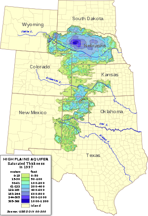
The depth of the Ogallala varies with the shape of then-prevailing surface, being deepest where it fills ancient valleys and channels. The Ogallala Formation consists mostly of coarse sedimentary rocks in its deeper sections, which transition upward into finer-grained material
Material
Material is anything made of matter, constituted of one or more substances. Wood, cement, hydrogen, air and water are all examples of materials. Sometimes the term "material" is used more narrowly to refer to substances or components with certain physical properties that are used as inputs to...
.
The water-permeated thickness of the Ogallala Formation ranges from a few feet to more than 1000 feet (300 m) and is generally greater in the northern plains. The depth of the water below the surface of the land ranges from almost 400 feet (122 m) in parts of the north to between 100 to 200 feet (30 to 61 m) throughout much of the south. Present-day recharge of the aquifer with fresh water occurs at an exceedingly slow rate suggesting that much of the water in its pore
Porosity
Porosity or void fraction is a measure of the void spaces in a material, and is a fraction of the volume of voids over the total volume, between 0–1, or as a percentage between 0–100%...
spaces is paleowater, dating back to the last ice age
Ice age
An ice age or, more precisely, glacial age, is a generic geological period of long-term reduction in the temperature of the Earth's surface and atmosphere, resulting in the presence or expansion of continental ice sheets, polar ice sheets and alpine glaciers...
and probably earlier. Withdrawals from the Ogallala are in essence mining ancient water.
Aquifer water balance
An aquifer is a groundwater storage reservoir in the water cycleWater cycle
The water cycle, also known as the hydrologic cycle or H2O cycle, describes the continuous movement of water on, above and below the surface of the Earth. Water can change states among liquid, vapor, and solid at various places in the water cycle...
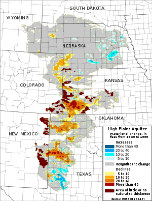
. While groundwater is a renewable source, reserves replenish relatively slowly. The USGS has performed several studies of the aquifer, to determine what is coming in (groundwater recharge from the surface), what is leaving (pumping and baseflow to streams) and what the net changes in storage are (rise, fall or no change — see figure above). Simply put, water in, minus the water out, is equal to the change in water stored in the aquifer. This type of mass-balance
Conservation of mass
The law of conservation of mass, also known as the principle of mass/matter conservation, states that the mass of an isolated system will remain constant over time...
"accounting" is how hydrologic budgets are performed, and is a crucial first step in sustainable management of any natural resource.
Withdrawals from the Ogallala Aquifer for irrigation amounted to 26 cubic kilometre in 2000. As of 2005, the total depletion since pre-development amounted to 253000000 acre.ft. Some estimates say it will dry up in as little as 25 years. Many farmers in the Texas High Plains
High Plains (United States)
The High Plains are a subregion of the Great Plains mostly in the Western United States, but also partly in the Midwest states of Nebraska, Kansas, and South Dakota, generally encompassing the western part of the Great Plains before the region reaches the Rocky Mountains...
, which rely particularly on the underground source, are now turning away from irrigated agriculture as they become aware of the hazards of overpumping.
Groundwater recharge
The rate at which recharge water enters the aquifer is limited by several factors. Much of the plains region is semi-aridSteppe
In physical geography, steppe is an ecoregion, in the montane grasslands and shrublands and temperate grasslands, savannas, and shrublands biomes, characterized by grassland plains without trees apart from those near rivers and lakes...
with steady winds that hasten evaporation of surface water and precipitation. In many locations, the aquifer is overlain, in the vadose zone
Vadose zone
The vadose zone, also termed the unsaturated zone, is the portion of Earth between the land surface and the top of the phreatic zone i.e. the position at which the groundwater is at atmospheric pressure . Hence the vadose zone extends from the top of the ground surface to the water table...
, with a shallow layer of caliche
Caliche (Mineral)
Caliche is a sedimentary rock, a hardened deposit of calcium carbonate. This calcium carbonate cements together other materials, including gravel, sand, clay, and silt. It is found in aridisol and mollisol soil orders...
that is practically impermeable
Hydraulic conductivity
Hydraulic conductivity, symbolically represented as K, is a property of vascular plants, soil or rock, that describes the ease with which water can move through pore spaces or fractures. It depends on the intrinsic permeability of the material and on the degree of saturation...
; this limits the amount of water able to recharge the aquifer from the land surface. However, the soil of the playa lakes is different and not lined with caliche, making these some of the few areas where the aquifer can recharge. The destruction of playas by farmers and development decreases the available recharge area. The prevalence of the caliche is partly due to the ready evaporation of soil moisture and the semi-arid climate; the aridity increases the amount of evaporation, which in turn increases the amount of caliche in the soil. Both mechanisms reinforce the difficulty that recharge has in reaching the water table.
Recharge in the aquifer ranges from 0.024 inch (0.6096 mm) per year in parts of Texas and New Mexico to up to 6 inches (152.4 mm) per year in south-central Kansas
Groundwater discharge
Livestock
Livestock refers to one or more domesticated animals raised in an agricultural setting to produce commodities such as food, fiber and labor. The term "livestock" as used in this article does not include poultry or farmed fish; however the inclusion of these, especially poultry, within the meaning...
, and growing corn
Maize
Maize known in many English-speaking countries as corn or mielie/mealie, is a grain domesticated by indigenous peoples in Mesoamerica in prehistoric times. The leafy stalk produces ears which contain seeds called kernels. Though technically a grain, maize kernels are used in cooking as a vegetable...
, wheat
Wheat
Wheat is a cereal grain, originally from the Levant region of the Near East, but now cultivated worldwide. In 2007 world production of wheat was 607 million tons, making it the third most-produced cereal after maize and rice...
and soybeans in the United States. (They have been called the "breadbasket of America"). The success of large-scale farming in areas that do not have adequate precipitation
Precipitation (meteorology)
In meteorology, precipitation In meteorology, precipitation In meteorology, precipitation (also known as one of the classes of hydrometeors, which are atmospheric water phenomena is any product of the condensation of atmospheric water vapor that falls under gravity. The main forms of precipitation...
and do not always have perennial surface water
Surface water
Surface water is water collecting on the ground or in a stream, river, lake, wetland, or ocean; it is related to water collecting as groundwater or atmospheric water....
for diversion has depended heavily on pumping groundwater for irrigation.
Early settlers of the semi-arid High Plains were plagued by crop failures due to cycles of drought
Drought
A drought is an extended period of months or years when a region notes a deficiency in its water supply. Generally, this occurs when a region receives consistently below average precipitation. It can have a substantial impact on the ecosystem and agriculture of the affected region...
, culminating in the disastrous Dust Bowl
Dust Bowl
The Dust Bowl, or the Dirty Thirties, was a period of severe dust storms causing major ecological and agricultural damage to American and Canadian prairie lands from 1930 to 1936...
of the 1930s. The aquifer was first tapped for irrigation
Irrigation
Irrigation may be defined as the science of artificial application of water to the land or soil. It is used to assist in the growing of agricultural crops, maintenance of landscapes, and revegetation of disturbed soils in dry areas and during periods of inadequate rainfall...
in 1911. Large-scale use for irrigation began in the 1930s and continued through the 1950s, due to the availability of electric power to rural farming communities and the development of cheap and efficient electric turbine pump
Pump
A pump is a device used to move fluids, such as liquids, gases or slurries.A pump displaces a volume by physical or mechanical action. Pumps fall into three major groups: direct lift, displacement, and gravity pumps...
s.
It was only after World War II
World War II
World War II, or the Second World War , was a global conflict lasting from 1939 to 1945, involving most of the world's nations—including all of the great powers—eventually forming two opposing military alliances: the Allies and the Axis...
that affordable technology became available to substantially extract water. This transformed the High Plains into one of the most agriculturally productive regions in the world. During the early years, this source of water was thought to be inexhaustible, and its hydrology a mystery. But, because the rate of extraction exceeds the rate of recharge, water level elevations are decreasing. At some places, the water table was measured to drop more than five feet (1.5 m) per year at the time of maximum extraction. In extreme cases, the deepening of well
Water well
A water well is an excavation or structure created in the ground by digging, driving, boring or drilling to access groundwater in underground aquifers. The well water is drawn by an electric submersible pump, a trash pump, a vertical turbine pump, a handpump or a mechanical pump...
s was required to reach the steadily falling water table. The water table has been drained (dewatered) in some places, such as Northern Texas. Utilizing treated recycled sources of water in agriculture is one approach at safeguarding the future of the aquifer. Another method to reducing the amount of water use is changing to crops that require less water, such as sunflower
Sunflower
Sunflower is an annual plant native to the Americas. It possesses a large inflorescence . The sunflower got its name from its huge, fiery blooms, whose shape and image is often used to depict the sun. The sunflower has a rough, hairy stem, broad, coarsely toothed, rough leaves and circular heads...
s.
Another issue is that several of the rivers in the region, such as the Platte
Platte River
The Platte River is a major river in the state of Nebraska and is about long. Measured to its farthest source via its tributary the North Platte River, it flows for over . The Platte River is a tributary of the Missouri River, which in turn is a tributary of the Mississippi River which flows to...
, run below the water level of the aquifer. Because of this, the rivers receive groundwater flow (baseflow), carrying it out of the region, rather than supplying recharge to the aquifer.
Change in groundwater storage
The USGS estimated that total water storage was about 2925000000 acre.ft in 2005. This is a decline of about 253000000 acre.ft (or 9%) since substantial ground-water irrigation development began, in the 1950s.Water conservation practices (terracing
Terrace (agriculture)
Terraces are used in farming to cultivate sloped land. Graduated terrace steps are commonly used to farm on hilly or mountainous terrain. Terraced fields decrease erosion and surface runoff, and are effective for growing crops requiring much water, such as rice...
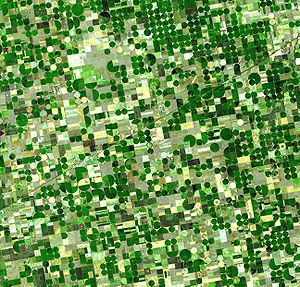
and crop rotation), more efficient irrigation methods (center pivot
Center pivot irrigation
Center-pivot irrigation , also called circle irrigation, is a method of crop irrigation in which equipment rotates around a pivot...
and drip), and simply reduced area under irrigation have helped to slow depletion of the aquifer, but levels are generally still dropping. See the figure above for an illustration of the places where large drops in water level have been observed (i.e., the brown areas in southwest Kansas
Kansas
Kansas is a US state located in the Midwestern United States. It is named after the Kansas River which flows through it, which in turn was named after the Kansa Native American tribe, which inhabited the area. The tribe's name is often said to mean "people of the wind" or "people of the south...
, and in or near the Texas panhandle
Texas Panhandle
The Texas Panhandle is a region of the U.S. state of Texas consisting of the northernmost 26 counties in the state. The panhandle is a rectangular area bordered by New Mexico to the west and Oklahoma to the north and east...
). In the more humid areas, such as eastern and central Nebraska
Nebraska
Nebraska is a state on the Great Plains of the Midwestern United States. The state's capital is Lincoln and its largest city is Omaha, on the Missouri River....
and south of Lubbock
Lubbock, Texas
Lubbock is a city in and the county seat of Lubbock County, Texas, United States. The city is located in the northwestern part of the state, a region known historically as the Llano Estacado, and the home of Texas Tech University and Lubbock Christian University...
, water levels have risen since 1980.
Environmental controversies
In the 21st century, the aquifer has received increased coverage from regional and international journalists.In the 1980s, Texas Panhandle
Texas Panhandle
The Texas Panhandle is a region of the U.S. state of Texas consisting of the northernmost 26 counties in the state. The panhandle is a rectangular area bordered by New Mexico to the west and Oklahoma to the north and east...
organic foods farmer
Farmer
A farmer is a person engaged in agriculture, who raises living organisms for food or raw materials, generally including livestock husbandry and growing crops, such as produce and grain...
and spokesman Frank Ford
Frank Ford (farmer)
Jesse Frank Ford, known as Frank Ford , was a Texas farmer and health-foods advocate who in 1960 founded Arrowhead Mills, the largest natural foods wholesaler in the United States. The company is based in Hereford, the seat of Deaf Smith County west of Amarillo in the Texas Panhandle...
successfully prevented the location of a nuclear waste repository in his native Deaf Smith County. He opposed the site on the grounds that the material could poison the Ogallala Aquifer. The repository was located instead in Yucca Mountain
Yucca Mountain
The Yucca Mountain Nuclear Waste Repository was to be a deep geological repository storage facility for spent nuclear reactor fuel and other high level radioactive waste, until the project was canceled in 2009. It was to be located on federal land adjacent to the Nevada Test Site in Nye County,...
in Nevada
Nevada
Nevada is a state in the western, mountain west, and southwestern regions of the United States. With an area of and a population of about 2.7 million, it is the 7th-largest and 35th-most populous state. Over two-thirds of Nevada's people live in the Las Vegas metropolitan area, which contains its...
.
In 2008, TransCanada Corporation proposed the construction of the 1661 miles (2,673.1 km) Keystone XL
Keystone Pipeline
The Keystone Pipeline System is a pipeline system to transport synthetic crude oil and diluted bitumen from the Athabasca Oil Sands in northeastern Alberta, Canada to multiple destinations in the United States, which include refineries in Illinois, Cushing oil distribution hub in Oklahoma, and...
pipeline to carry oil from the Athabasca oil sands
Athabasca Oil Sands
The Athabasca oil sands are large deposits of bitumen, or extremely heavy crude oil, located in northeastern Alberta, Canada - roughly centred on the boomtown of Fort McMurray...
of Alberta
Alberta
Alberta is a province of Canada. It had an estimated population of 3.7 million in 2010 making it the most populous of Canada's three prairie provinces...
to refineries near Houston, Texas
Houston, Texas
Houston is the fourth-largest city in the United States, and the largest city in the state of Texas. According to the 2010 U.S. Census, the city had a population of 2.1 million people within an area of . Houston is the seat of Harris County and the economic center of , which is the ...
.
The proposed route of the pipeline crossed the eastern part of the Nebraska Sandhills; opponents of the project argued that this route posed an unacceptable risk to the Ogallala Aquifer owing to the possibility of contamination from oil spills.
In August 2011, an environmental-impact report by the U.S. State Department
United States Department of State
The United States Department of State , is the United States federal executive department responsible for international relations of the United States, equivalent to the foreign ministries of other countries...
found the Sandhills route would be the most economically feasible, and would be unlikely to have significant environmental impacts.
- See also: Risk to Ogallala Aquifer
In popular culture
- The aquifer figures prominently in the novel That Old Ace in the HoleThat Old Ace in the Hole-Plot:Bob Dollar is sent by his employer, the multinational "Global Pork Rind Corporation", to scout for locations for intensive hog farming in the Texas Panhandle. Dollar goes about the work of meeting local down-on-their-luck farmers to manipulate them into selling out...
(2002) by E. Annie Proulx. - It forms part of the historical background of the plot of the Canadian television mini-series H2OH2O (film)H2O is a Canadian political drama two-part miniseries that first aired on the CBC Television October 31, 2004. It starred Paul Gross and Leslie Hope, with former politician Belinda Stronach making a cameo appearance. Written by Gross and John Krizanc and directed by Charles Binamé, it was nominated...
. - Featured in the final chapter, "Power and Change", of James A. MichenerJames A. MichenerJames Albert Michener was an American author of more than 40 titles, the majority of which were sweeping sagas, covering the lives of many generations in particular geographic locales and incorporating historical facts into the stories...
's novelNovelA novel is a book of long narrative in literary prose. The genre has historical roots both in the fields of the medieval and early modern romance and in the tradition of the novella. The latter supplied the present generic term in the late 18th century....
TexasTexas (novel)Texas is a novel by James A. Michener based on the history of the Lone Star State. Characters include real and fictional characters, explorers , Spanish and German Texan settlers, ranchers, oil men, aristocrats, Chicanos, and others, all based on extensive historical research.Although Michener...
(1985). - Figures in a plot for world domination in the Amazing Spider-ManSpider-ManSpider-Man is a fictional Marvel Comics superhero. The character was created by writer-editor Stan Lee and writer-artist Steve Ditko. He first appeared in Amazing Fantasy #15...
comic book made by Marvel Comics. - Near-total depletion of the aquifer figures as a minor plot devicePlot deviceA plot device is an object or character in a story whose sole purpose is to advance the plot of the story, or alternatively to overcome some difficulty in the plot....
contributing to the second Dust BowlDust BowlThe Dust Bowl, or the Dirty Thirties, was a period of severe dust storms causing major ecological and agricultural damage to American and Canadian prairie lands from 1930 to 1936...
in David BrinDavid BrinGlen David Brin, Ph.D. is an American scientist and award-winning author of science fiction. He has received the Hugo, Locus, Campbell and Nebula Awards.-Biography:...
's futuristic novel, EarthEarth (novel)Earth is a 1990 science fiction novel written by David Brin. The book was nominated for the Hugo and Locus Awards in 1991.-Plot introduction:...
(1990).
See also
- AquiferAquiferAn aquifer is a wet underground layer of water-bearing permeable rock or unconsolidated materials from which groundwater can be usefully extracted using a water well. The study of water flow in aquifers and the characterization of aquifers is called hydrogeology...
- Fossil waterFossil waterFossil water or paleowater is groundwater that has remained sealed in an aquifer for a long period of time. Water can rest underground in "fossil aquifers" for thousands or even millions of years...
- GroundwaterGroundwaterGroundwater is water located beneath the ground surface in soil pore spaces and in the fractures of rock formations. A unit of rock or an unconsolidated deposit is called an aquifer when it can yield a usable quantity of water. The depth at which soil pore spaces or fractures and voids in rock...
- HydrogeologyHydrogeologyHydrogeology is the area of geology that deals with the distribution and movement of groundwater in the soil and rocks of the Earth's crust, . The term geohydrology is often used interchangeably...
- IrrigationIrrigationIrrigation may be defined as the science of artificial application of water to the land or soil. It is used to assist in the growing of agricultural crops, maintenance of landscapes, and revegetation of disturbed soils in dry areas and during periods of inadequate rainfall...
- Laurentide Ice SheetLaurentide ice sheetThe Laurentide Ice Sheet was a massive sheet of ice that covered hundreds of thousands of square miles, including most of Canada and a large portion of the northern United States, multiple times during Quaternary glacial epochs. It last covered most of northern North America between c. 95,000 and...
- Llano EstacadoLlano EstacadoLlano Estacado , commonly known as the Staked Plains, is a region in the Southwestern United States that encompasses parts of eastern New Mexico and northwestern Texas, including the South Plains and parts of the Texas Panhandle...
- Water tableWater tableThe water table is the level at which the submarine pressure is far from atmospheric pressure. It may be conveniently visualized as the 'surface' of the subsurface materials that are saturated with groundwater in a given vicinity. However, saturated conditions may extend above the water table as...
External links
- "The Ogallala Aquifer" Manjula V. Guru, Agricultural Policy Specialist and James E. Horne, President & CEO, The Kerr Center for Sustainable Agriculture, Poteau, Oklahoma
- USGS High Plains Regional Groundwater Study
- A Legal Fight in Texas over the Ogallala Aquifer
- Kansas Geological Survey information on the High Plains / Ogallala Aquifer
- Rapid Recharge of Parts of the High Plains Aquifer Indicated by a Reconnaissance Study in Oklahoma