
Time in the United States
Encyclopedia
Time in the United States, by law, is divided into nine standard time zone
s covering the states and its possessions, with most of the United States
observing daylight saving time
for part of the year.
The time zone boundaries and DST observance are under the authority of the Department of Transportation
.
Official and highly precise timekeeping services (clocks) are provided by two federal time agencies: a Department of Commerce agency, the National Institute of Standards and Technology
(NIST), and its military counterpart, the United States Naval Observatory
(USNO). The clocks run by these services are kept synchronized with each other as well as with those of international time keeping organizations.
It is the combination of the time zone and daylight saving rules along with the time keeping services which determines the legal civil time
for any U.S. location at any moment.
§260. The federal law also establishes the transition dates and times at which daylight saving time
occurs, if observed. It is ultimately the authority of the Secretary of Transportation
, in coordination with the states, to determine which regions will observe which of the standard time zones and if they will observe daylight saving time. As of August 9, 2007, the standard time zones are defined in terms of hourly offsets from UTC
. Prior to this they were based upon the mean solar time
at several meridians 15° apart west of Greenwich
(GMT
).
Only the full time zone names listed below are official; abbreviations are by common use conventions.
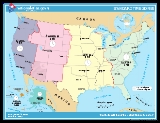
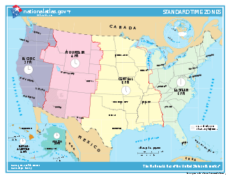
The United States uses nine standard time zones. From east to west they are Atlantic Standard Time (AST), Eastern Standard Time (EST), Central Standard Time (CST), Mountain Standard Time (MST), Pacific Standard Time (PST), Alaskan Standard Time (AKST), Hawaii-Aleutian Standard Time (HST), Samoa standard time (UTC−11) and Chamorro Standard Time (UTC+10). View the standard time zone boundaries.
http://www.timetemperature.com/tzus/time_zone.shtml
are:
are outside the time zones defined by 15 U.S.C. §260 and exist in waters defined by Nautical time
. Baker Island
and Howland Island
are in UTC−12, while Wake Island
is in UTC+12
. Because they exist on opposite sides of the International Date Line
, it can, for example, be noon Wednesday on Baker and Howland islands while simultaneously being noon Thursday on Wake Island. Other outlying islands include Jarvis Island
, Midway Atoll
, Palmyra Atoll
and Kingman Reef
(UTC−11); Johnston Atoll
(UTC−10); and Navassa Island
, Bajo Nuevo Bank
and Serranilla Bank
(UTC−05).
extended daylight saving time (DST)
for an additional month beginning in 2007. The start of DST now occurs on the second Sunday in March and ends on the first Sunday in November.
The Energy Policy Act specifies that continuation of daylight saving time beyond 2008 is subject to favorable evaluation of the energy savings attained. Unless the expanded DST period is rescinded, clocks will be set ahead one hour at 2 a.m. on the following start dates and set back one hour at 2 a.m. on these ending dates:
In response to the Uniform Time Act
of 1966, each state of the US has officially chosen to apply one of two rules over its entire territory:
Time zone
A time zone is a region on Earth that has a uniform standard time for legal, commercial, and social purposes. In order for the same clock time to always correspond to the same portion of the day as the Earth rotates , different places on the Earth need to have different clock times...
s covering the states and its possessions, with most of the United States
United States
The United States of America is a federal constitutional republic comprising fifty states and a federal district...
observing daylight saving time
Daylight saving time
Daylight saving time —also summer time in several countries including in British English and European official terminology —is the practice of temporarily advancing clocks during the summertime so that afternoons have more daylight and mornings have less...
for part of the year.
The time zone boundaries and DST observance are under the authority of the Department of Transportation
United States Department of Transportation
The United States Department of Transportation is a federal Cabinet department of the United States government concerned with transportation. It was established by an act of Congress on October 15, 1966, and began operation on April 1, 1967...
.
Official and highly precise timekeeping services (clocks) are provided by two federal time agencies: a Department of Commerce agency, the National Institute of Standards and Technology
National Institute of Standards and Technology
The National Institute of Standards and Technology , known between 1901 and 1988 as the National Bureau of Standards , is a measurement standards laboratory, otherwise known as a National Metrological Institute , which is a non-regulatory agency of the United States Department of Commerce...
(NIST), and its military counterpart, the United States Naval Observatory
United States Naval Observatory
The United States Naval Observatory is one of the oldest scientific agencies in the United States, with a primary mission to produce Positioning, Navigation, and Timing for the U.S. Navy and the U.S. Department of Defense...
(USNO). The clocks run by these services are kept synchronized with each other as well as with those of international time keeping organizations.
It is the combination of the time zone and daylight saving rules along with the time keeping services which determines the legal civil time
Civil time
In modern usage, civil time refers to statutory time scales designated by civilian authorities, or to local time indicated by clocks. Modern civil time is generally standard time in a time zone at a fixed offset from Coordinated Universal Time or from Greenwich Mean Time , possibly adjusted by...
for any U.S. location at any moment.
United States time zones
Standard time zones in the United States are currently defined at the federal level by law 15 U.S.C.Title 15 of the United States Code
Title 15 of the United States Code outlines the role of the commerce and trade in the United States Code.Notable legislation in the title includes the Federal Trade Commission Act, the Clayton Antitrust Act, the Sherman Antitrust Act, the Securities Exchange Act of 1934, the Consumer Product Safety...
§260. The federal law also establishes the transition dates and times at which daylight saving time
Daylight saving time
Daylight saving time —also summer time in several countries including in British English and European official terminology —is the practice of temporarily advancing clocks during the summertime so that afternoons have more daylight and mornings have less...
occurs, if observed. It is ultimately the authority of the Secretary of Transportation
United States Secretary of Transportation
The United States Secretary of Transportation is the head of the United States Department of Transportation, a member of the President's Cabinet, and fourteenth in the Presidential line of succession. The post was created with the formation of the Department of Transportation on October 15, 1966,...
, in coordination with the states, to determine which regions will observe which of the standard time zones and if they will observe daylight saving time. As of August 9, 2007, the standard time zones are defined in terms of hourly offsets from UTC
Coordinated Universal Time
Coordinated Universal Time is the primary time standard by which the world regulates clocks and time. It is one of several closely related successors to Greenwich Mean Time. Computer servers, online services and other entities that rely on having a universally accepted time use UTC for that purpose...
. Prior to this they were based upon the mean solar time
Solar time
Solar time is a reckoning of the passage of time based on the Sun's position in the sky. The fundamental unit of solar time is the day. Two types of solar time are apparent solar time and mean solar time .-Introduction:...
at several meridians 15° apart west of Greenwich
Royal Observatory, Greenwich
The Royal Observatory, Greenwich , in London, England played a major role in the history of astronomy and navigation, and is best known as the location of the prime meridian...
(GMT
Greenwich Mean Time
Greenwich Mean Time is a term originally referring to mean solar time at the Royal Observatory in Greenwich, London. It is arguably the same as Coordinated Universal Time and when this is viewed as a time zone the name Greenwich Mean Time is especially used by bodies connected with the United...
).
Only the full time zone names listed below are official; abbreviations are by common use conventions.
The United States uses nine standard time zones. From east to west they are Atlantic Standard Time (AST), Eastern Standard Time (EST), Central Standard Time (CST), Mountain Standard Time (MST), Pacific Standard Time (PST), Alaskan Standard Time (AKST), Hawaii-Aleutian Standard Time (HST), Samoa standard time (UTC−11) and Chamorro Standard Time (UTC+10). View the standard time zone boundaries.
http://www.timetemperature.com/tzus/time_zone.shtml
Zones used in the contiguous U.S.
From east to west, the times zones of the contiguous United StatesContiguous United States
The contiguous United States are the 48 U.S. states on the continent of North America that are south of Canada and north of Mexico, plus the District of Columbia....
are:
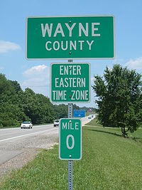
- Eastern standard time zoneEastern Time ZoneThe Eastern Time Zone of the United States and Canada is a time zone that falls mostly along the east coast of North America. Its UTC time offset is −5 hrs during standard time and −4 hrs during daylight saving time...
: (EST; UTC−05; Zone R), which comprises roughly the states on the Atlantic coastEast Coast of the United StatesThe East Coast of the United States, also known as the Eastern Seaboard, refers to the easternmost coastal states in the United States, which touch the Atlantic Ocean and stretch up to Canada. The term includes the U.S...
and the eastern two thirds of the Ohio ValleyOhio RiverThe Ohio River is the largest tributary, by volume, of the Mississippi River. At the confluence, the Ohio is even bigger than the Mississippi and, thus, is hydrologically the main stream of the whole river system, including the Allegheny River further upstream...
. - Central standard time zone: (CST; UTC−06; Zone S), which comprises roughly the Gulf CoastGulf Coast of the United StatesThe Gulf Coast of the United States, sometimes referred to as the Gulf South, South Coast, or 3rd Coast, comprises the coasts of American states that are on the Gulf of Mexico, which includes Texas, Louisiana, Mississippi, Alabama, and Florida and are known as the Gulf States...
, Mississippi Valley, and Great PlainsGreat PlainsThe Great Plains are a broad expanse of flat land, much of it covered in prairie, steppe and grassland, which lies west of the Mississippi River and east of the Rocky Mountains in the United States and Canada. This area covers parts of the U.S...
. - Mountain standard time zoneMountain Time ZoneThe Mountain Time Zone of North America keeps time by subtracting seven hours from Coordinated Universal Time, also known as Greenwich Mean Time, during the shortest days of autumn and winter , and by subtracting six hours during daylight saving time in the spring, summer, and early autumn...
: (MST; UTC−07; Zone T), which comprises roughly the states that include the Rocky MountainsRocky MountainsThe Rocky Mountains are a major mountain range in western North America. The Rocky Mountains stretch more than from the northernmost part of British Columbia, in western Canada, to New Mexico, in the southwestern United States...
. - Pacific standard time zonePacific Time ZoneThe Pacific Time Zone observes standard time by subtracting eight hours from Coordinated Universal Time . The clock time in this zone is based on the mean solar time of the 120th meridian west of the Greenwich Observatory. During daylight saving time, its time offset is UTC-7.In the United States...
: (PST; UTC−08; Zone U), which comprises roughly the states on the Pacific coastPacific CoastA country's Pacific coast is the part of its coast bordering the Pacific Ocean.-The Americas:Countries on the western side of the Americas have a Pacific coast as their western border.* Geography of Canada* Geography of Chile* Geography of Colombia...
, plus NevadaNevadaNevada is a state in the western, mountain west, and southwestern regions of the United States. With an area of and a population of about 2.7 million, it is the 7th-largest and 35th-most populous state. Over two-thirds of Nevada's people live in the Las Vegas metropolitan area, which contains its...
.
Zones used in states beyond the contiguous U.S.
- Alaska standard time zoneAlaska Time ZoneThe Alaska Time Zone observes standard time by subtracting nine hours from Coordinated Universal Time . During daylight saving time its time offset is only eight hours . The clock time in this zone is based on the mean solar time of the 135th meridian west of the Greenwich Observatory.The zone...
: (AKST; UTC−09; Zone V), which comprises most of the state of AlaskaAlaskaAlaska is the largest state in the United States by area. It is situated in the northwest extremity of the North American continent, with Canada to the east, the Arctic Ocean to the north, and the Pacific Ocean to the west and south, with Russia further west across the Bering Strait...
. - Hawaii-Aleutian standard time zoneHawaii-Aleutian time zoneThe Hawaii-Aleutian Time Zone observes Hawaii-Aleutian Standard Time , by subtracting ten hours from Coordinated Universal Time . The clock time in this zone is based on the mean solar time of the 150th meridian west of the Greenwich Observatory....
: (or unofficially Hawaii Standard Time: HST) (HAST; UTC−10; zone W), which includes HawaiiHawaiiHawaii is the newest of the 50 U.S. states , and is the only U.S. state made up entirely of islands. It is the northernmost island group in Polynesia, occupying most of an archipelago in the central Pacific Ocean, southwest of the continental United States, southeast of Japan, and northeast of...
and most of the length of the Aleutian Islands chain (west of 169°30′W).
Zones outside the states
- Atlantic standard time zoneAtlantic Standard Time ZoneThe Atlantic Standard Time Zone is a geographical region that keeps time by subtracting four hours from either Coordinated Universal Time or Greenwich Mean Time , resulting in UTC-4 or GMT-4...
: (AST; UTC−04; Zone Q), which comprises Puerto RicoPuerto RicoPuerto Rico , officially the Commonwealth of Puerto Rico , is an unincorporated territory of the United States, located in the northeastern Caribbean, east of the Dominican Republic and west of both the United States Virgin Islands and the British Virgin Islands.Puerto Rico comprises an...
and the U.S. Virgin IslandsUnited States Virgin IslandsThe Virgin Islands of the United States are a group of islands in the Caribbean that are an insular area of the United States. The islands are geographically part of the Virgin Islands archipelago and are located in the Leeward Islands of the Lesser Antilles.The U.S...
. - Samoa standard time zoneSamoa Time Zonethumb|right|250px|SST is [[UTC-11]]The Samoa Time Zone observes standard time by subtracting eleven hours from Coordinated Universal Time . The clock time in this zone is based on the mean solar time of the 165th meridian west west of the Greenwich Observatory.The zone includes the U.S...
(SST; UTC−11; Zone X), which comprises American SamoaAmerican SamoaAmerican Samoa is an unincorporated territory of the United States located in the South Pacific Ocean, southeast of the sovereign state of Samoa...
. - Chamorro standard time zoneChamorro Time ZoneThe Chamorro Time Zone, formerly the Guam Time Zone, observes standard time by adding ten hours to Coordinated Universal Time . The clock time in this zone is based on the mean solar time of the 150th meridian east of the Greenwich Observatory....
: (ChST; UTC+10UTC+10UTC+10 is an identifier for a time offset from UTC of +10. This time is used in:-As standard time :*Australia **Queensland*Federated States of Micronesia**Chuuk, Yap and surrounding area...
; Zone K), which comprises GuamGuamGuam is an organized, unincorporated territory of the United States located in the western Pacific Ocean. It is one of five U.S. territories with an established civilian government. Guam is listed as one of 16 Non-Self-Governing Territories by the Special Committee on Decolonization of the United...
and the Northern Mariana IslandsNorthern Mariana IslandsThe Northern Mariana Islands, officially the Commonwealth of the Northern Mariana Islands , is a commonwealth in political union with the United States, occupying a strategic region of the western Pacific Ocean. It consists of 15 islands about three-quarters of the way from Hawaii to the Philippines...
.
Minor Outlying Islands
Some United States Minor Outlying IslandsUnited States Minor Outlying Islands
The United States Minor Outlying Islands, a statistical designation defined by the International Organization for Standardization's ISO 3166-1 code, consists of nine United States insular areas in the Pacific Ocean and Caribbean Sea: Baker Island, Howland Island, Jarvis Island, Johnston Atoll,...
are outside the time zones defined by 15 U.S.C. §260 and exist in waters defined by Nautical time
Nautical time
The establishment of nautical standard times, nautical standard time zones and the nautical date line were recommended by the Anglo-French Conference on Time-keeping at Sea in 1917. The Conference recommended that the standard apply to all ships, both military and civilian...
. Baker Island
Baker Island
Baker Island is an uninhabited atoll located just north of the equator in the central Pacific Ocean about southwest of Honolulu. The island lies almost halfway between Hawaii and Australia, and is a possession of the United States. Its nearest neighbor is Howland Island, to the north.Located at...
and Howland Island
Howland Island
Howland Island is an uninhabited coral island located just north of the equator in the central Pacific Ocean, about southwest of Honolulu. The island lies almost halfway between Hawaii and Australia and is an unincorporated, unorganized territory of the United States. Geographically, it is part...
are in UTC−12, while Wake Island
Wake Island
Wake Island is a coral atoll having a coastline of in the North Pacific Ocean, located about two-thirds of the way from Honolulu west to Guam east. It is an unorganized, unincorporated territory of the United States, administered by the Office of Insular Affairs, U.S. Department of the Interior...
is in UTC+12
UTC+12
UTC+12:00 is an identifier for a +12 hour time offset from UTC. This time is used in:-As standard time :*Kiribati**Gilbert Islands and Banaba*Marshall Islands*Nauru*Russia**Chukotka Autonomous Okrug**Kamchatka Krai**Kuril Islands...
. Because they exist on opposite sides of the International Date Line
International Date Line
The International Date Line is a generally north-south imaginary line on the surface of the Earth, passing through the middle of the Pacific Ocean, that designates the place where each calendar day begins...
, it can, for example, be noon Wednesday on Baker and Howland islands while simultaneously being noon Thursday on Wake Island. Other outlying islands include Jarvis Island
Jarvis Island
Jarvis Island is an uninhabited 4.5 square kilometer coral island located in the South Pacific Ocean at , about halfway between Hawaii and the Cook Islands...
, Midway Atoll
Midway Atoll
Midway Atoll is a atoll in the North Pacific Ocean, near the northwestern end of the Hawaiian archipelago, about one-third of the way between Honolulu, Hawaii, and Tokyo, Japan. Unique among the Hawaiian islands, Midway observes UTC-11 , eleven hours behind Coordinated Universal Time and one hour...
, Palmyra Atoll
Palmyra Atoll
Palmyra Atoll is an essentially unoccupied equatorial Northern Pacific atoll administered as an unorganized incorporated territory by the United States federal government...
and Kingman Reef
Kingman Reef
Kingman Reef is a largely submerged, uninhabited triangular shaped reef, east-west and north-south, located in the North Pacific Ocean, roughly half way between the Hawaiian Islands and American Samoa at...
(UTC−11); Johnston Atoll
Johnston Atoll
Johnston Atoll is a atoll in the North Pacific Ocean about west of Hawaii. There are four islands located on the coral reef platform, two natural islands, Johnston Island and Sand Island, which have been expanded by coral dredging, as well as North Island and East Island , an additional two...
(UTC−10); and Navassa Island
Navassa Island
Navassa Island is a small, uninhabited island in the Caribbean Sea, claimed as an unorganized unincorporated territory of the United States, which administers it through the U.S. Fish and Wildlife Service. Haiti, which claims to have had sovereignty over Navassa since 1801, also claims the island...
, Bajo Nuevo Bank
Bajo Nuevo Bank
Bajo Nuevo Bank, also known as the Petrel Islands , is a small, uninhabited reef with some small islets, covered with grass, located in the western Caribbean Sea at , with a lighthouse on Low Cay at . The closest neighbouring land feature is Serranilla Bank, located to the west.The reef was first...
and Serranilla Bank
Serranilla Bank
Serranilla Bank is a partially submerged reef, with small uninhabited islets, in the western Caribbean Sea. It is situated about northeast of Punta Gorda, Nicaragua, and roughly southwest of Jamaica. The closest neighbouring land feature is Bajo Nuevo Bank, located 110 km to the east.Serranilla...
(UTC−05).
EST/CST boundary
- roughly follows the border between WisconsinWisconsinWisconsin is a U.S. state located in the north-central United States and is part of the Midwest. It is bordered by Minnesota to the west, Iowa to the southwest, Illinois to the south, Lake Michigan to the east, Michigan to the northeast, and Lake Superior to the north. Wisconsin's capital is...
(to the south and west) and the Upper PeninsulaUpper Peninsula of MichiganThe Upper Peninsula of Michigan is the northern of the two major land masses that make up the U.S. state of Michigan. It is commonly referred to as the Upper Peninsula, the U.P., or Upper Michigan. It is also known as the land "above the Bridge" linking the two peninsulas. The peninsula is bounded...
of MichiganMichiganMichigan is a U.S. state located in the Great Lakes Region of the United States of America. The name Michigan is the French form of the Ojibwa word mishigamaa, meaning "large water" or "large lake"....
(to the north and east); the Upper Peninsula counties that border on Wisconsin observe CT, all other counties in the U.P. observe ET - follows Lake MichiganLake MichiganLake Michigan is one of the five Great Lakes of North America and the only one located entirely within the United States. It is the second largest of the Great Lakes by volume and the third largest by surface area, after Lake Superior and Lake Huron...
- divides a small portion of Northwestern IndianaNorthwest IndianaNorthwest Indiana, also known as the South Shore and The Calumet Region or simply The Region, comprises Lake, Porter, LaPorte, Newton and Jasper counties in Indiana. This region neighbors Lake Michigan and is part of the Chicago metropolitan area...
near ChicagoChicagoChicago is the largest city in the US state of Illinois. With nearly 2.7 million residents, it is the most populous city in the Midwestern United States and the third most populous in the US, after New York City and Los Angeles...
from the rest of the state - follows the border between IllinoisIllinoisIllinois is the fifth-most populous state of the United States of America, and is often noted for being a microcosm of the entire country. With Chicago in the northeast, small industrial cities and great agricultural productivity in central and northern Illinois, and natural resources like coal,...
(west) and Indiana (east) - divides a small portion of Southwestern IndianaSouthwestern IndianaSouthwestern Indiana is a 11-county region of Indiana located at the southernmost and westernmost part of the state. As of the 2000 census, the region's combined population is 465,338. Evansville, Indiana's third largest city, is the primary hub for the region as well as the primary regional hub...
from the rest of the state - divides KentuckyKentuckyThe Commonwealth of Kentucky is a state located in the East Central United States of America. As classified by the United States Census Bureau, Kentucky is a Southern state, more specifically in the East South Central region. Kentucky is one of four U.S. states constituted as a commonwealth...
in half roughly along a line that is west of Louisville, KentuckyLouisville, KentuckyLouisville is the largest city in the U.S. state of Kentucky, and the county seat of Jefferson County. Since 2003, the city's borders have been coterminous with those of the county because of a city-county merger. The city's population at the 2010 census was 741,096...
running from northwest to southeast. - divides the region legally defined as East TennesseeEast TennesseeEast Tennessee is a name given to approximately the eastern third of the U.S. state of Tennessee, one of the three Grand Divisions of Tennessee defined in state law. East Tennessee consists of 33 counties, 30 located within the Eastern Time Zone and three counties in the Central Time Zone, namely...
, except for four counties adjoining Middle TennesseeMiddle TennesseeMiddle Tennessee is a distinct portion of the state of Tennessee, delineated according to state law as the 41 counties in the Middle Grand Division of Tennessee....
, from the rest of TennesseeTennesseeTennessee is a U.S. state located in the Southeastern United States. It has a population of 6,346,105, making it the nation's 17th-largest state by population, and covers , making it the 36th-largest by total land area...
. - follows the border between AlabamaAlabamaAlabama is a state located in the southeastern region of the United States. It is bordered by Tennessee to the north, Georgia to the east, Florida and the Gulf of Mexico to the south, and Mississippi to the west. Alabama ranks 30th in total land area and ranks second in the size of its inland...
(west) and GeorgiaGeorgia (U.S. state)Georgia is a state located in the southeastern United States. It was established in 1732, the last of the original Thirteen Colonies. The state is named after King George II of Great Britain. Georgia was the fourth state to ratify the United States Constitution, on January 2, 1788...
(east) - divides the panhandleFlorida PanhandleThe Florida Panhandle, an informal, unofficial term for the northwestern part of Florida, is a strip of land roughly 200 miles long and 50 to 100 miles wide , lying between Alabama on the north and the west, Georgia also on the north, and the Gulf of Mexico to the south. Its eastern boundary is...
of Florida along the Apalachicola RiverApalachicola RiverThe Apalachicola River is a river, approximately 112 mi long in the State of Florida. This river's large watershed, known as the ACF River Basin for short, drains an area of approximately into the Gulf of Mexico. The distance to its farthest headstream in northeast Georgia is approximately 500...
and Intracoastal WaterwayIntracoastal WaterwayThe Intracoastal Waterway is a 3,000-mile waterway along the Atlantic and Gulf coasts of the United States. Some lengths consist of natural inlets, salt-water rivers, bays, and sounds; others are artificial canals...
just west of Tallahassee, FloridaTallahassee, FloridaTallahassee is the capital of the U.S. state of Florida. It is the county seat and only incorporated municipality in Leon County, and is the 128th largest city in the United States. Tallahassee became the capital of Florida, then the Florida Territory, in 1824. In 2010, the population recorded by...
.
CST/MST boundary
- divides the southwest portion of North DakotaNorth DakotaNorth Dakota is a state located in the Midwestern region of the United States of America, along the Canadian border. The state is bordered by Canada to the north, Minnesota to the east, South Dakota to the south and Montana to the west. North Dakota is the 19th-largest state by area in the U.S....
from the rest of the state - divides South DakotaSouth DakotaSouth Dakota is a state located in the Midwestern region of the United States. It is named after the Lakota and Dakota Sioux American Indian tribes. Once a part of Dakota Territory, South Dakota became a state on November 2, 1889. The state has an area of and an estimated population of just over...
roughly in half - divides the western third of NebraskaNebraskaNebraska is a state on the Great Plains of the Midwestern United States. The state's capital is Lincoln and its largest city is Omaha, on the Missouri River....
from the rest of the state - divides a very small portion of extreme western KansasKansasKansas is a US state located in the Midwestern United States. It is named after the Kansas River which flows through it, which in turn was named after the Kansa Native American tribe, which inhabited the area. The tribe's name is often said to mean "people of the wind" or "people of the south...
bordering ColoradoColoradoColorado is a U.S. state that encompasses much of the Rocky Mountains as well as the northeastern portion of the Colorado Plateau and the western edge of the Great Plains...
(GreeleyGreeley County, KansasGreeley County is a county located in West Central Kansas, in the Central United States. As of the 2010 census, the county population was 1,247, which is the lowest in Kansas. Its county seat and largest town is Tribune...
, HamiltonHamilton County, KansasHamilton County is a county located in Southwest Kansas, in the Central United States. As of the 2010 census, the county population was 2,690...
, ShermanSherman County, KansasSherman County is a county located in the U.S. state of Kansas. As of the 2010 census, the county population was 6,010...
and WallaceWallace County, KansasWallace County is a county located in the U.S. state of Kansas. As of the 2010 census, the county population was 1,485. It has the second lowest population of any county in Kansas. Greeley County has the lowest. Its county seat is Sharon Springs. It was created in 1868 and named in honor of...
counties) from the rest of the state (three other counties which border ColoradoColoradoColorado is a U.S. state that encompasses much of the Rocky Mountains as well as the northeastern portion of the Colorado Plateau and the western edge of the Great Plains...
—CheyenneCheyenne County, KansasCheyenne County is a county located in Northwest Kansas, in the Central United States. As of the 2010 census, the county population was 2,726. Its county seat and most populous city is St...
, MortonMorton County, KansasMorton County is a county located in the U.S. state of Kansas. As of the 2010 census, the county population was 3,233...
and StantonStanton County, KansasStanton County is a county located in the U.S. state of Kansas. As of the 2010 census, the county population was 2,235...
—observe CST) - follows the border between New MexicoNew MexicoNew Mexico is a state located in the southwest and western regions of the United States. New Mexico is also usually considered one of the Mountain States. With a population density of 16 per square mile, New Mexico is the sixth-most sparsely inhabited U.S...
(west) and OklahomaOklahomaOklahoma is a state located in the South Central region of the United States of America. With an estimated 3,751,351 residents as of the 2010 census and a land area of 68,667 square miles , Oklahoma is the 28th most populous and 20th-largest state...
(east) - follows the border between New Mexico (west) and TexasTexasTexas is the second largest U.S. state by both area and population, and the largest state by area in the contiguous United States.The name, based on the Caddo word "Tejas" meaning "friends" or "allies", was applied by the Spanish to the Caddo themselves and to the region of their settlement in...
(east) - divides El Paso County and Hudspeth CountyHudspeth County, TexasHudspeth County is a county located in the U.S. state of Texas. It is one of the nine counties that comprise the Trans-Pecos region of West Texas. As of 2000, the population was 3,344. By 2010, the population had increased to 3,476. Its county seat is Sierra Blanca. The largest city is Fort Hancock...
from the rest of Texas
MST/PST boundary
- follows the border between northern IdahoIdahoIdaho is a state in the Rocky Mountain area of the United States. The state's largest city and capital is Boise. Residents are called "Idahoans". Idaho was admitted to the Union on July 3, 1890, as the 43rd state....
(west) and northwestern MontanaMontanaMontana is a state in the Western United States. The western third of Montana contains numerous mountain ranges. Smaller, "island ranges" are found in the central third of the state, for a total of 77 named ranges of the Rocky Mountains. This geographical fact is reflected in the state's name,...
(east) - turns west at 45°33.46′ N, 114°33.89′ W (just south of Nez Perce Pass), and follows the Idaho County line to the Salmon River
- follows the Salmon RiverSalmon River (Idaho)The Salmon River is located in Idaho in the northwestern United States. The Salmon is also known as The River of No Return. It flows for through central Idaho, draining and dropping more than between its headwaters, near Galena Summit above the Sawtooth Valley in the Sawtooth National...
west to the town of Riggins, where the Salmon River turns north. Although this puts the southern part of Idaho County in the Mountain Time Zone, the towns of Burgdorf and Warren, which are south of the Salmon River, observe Pacific time. - follows the Salmon River north to the Snake RiverSnake RiverThe Snake is a major river of the greater Pacific Northwest in the United States. At long, it is the largest tributary of the Columbia River, the largest North American river that empties into the Pacific Ocean...
at the Oregon border (at 45°51.3′ N, 116°47.5′ W). Interestingly, this loop to the north creates a curious situation where one can change into a more-westerly time zone by traveling East. - follows the Snake RiverSnake RiverThe Snake is a major river of the greater Pacific Northwest in the United States. At long, it is the largest tributary of the Columbia River, the largest North American river that empties into the Pacific Ocean...
south between OregonOregonOregon is a state in the Pacific Northwest region of the United States. It is located on the Pacific coast, with Washington to the north, California to the south, Nevada on the southeast and Idaho to the east. The Columbia and Snake rivers delineate much of Oregon's northern and eastern...
(west) and Idaho (east) to the northern border of Malheur County, Oregon - follows the northern border of Malheur County, Oregon to its western border, where it turns South
- follows the western border of Malheur County to latitude 42°27′ N, where it turns East, and returns to the Oregon/Idaho border
- follows the border between OregonOregonOregon is a state in the Pacific Northwest region of the United States. It is located on the Pacific coast, with Washington to the north, California to the south, Nevada on the southeast and Idaho to the east. The Columbia and Snake rivers delineate much of Oregon's northern and eastern...
(west) and Idaho (east) - follows the border (42° N42nd parallel northThe 42nd parallel north is a circle of latitude that is 42 degrees north of the Earth's equatorial plane. It crosses Europe, the Mediterranean Sea, Asia, the Pacific Ocean, North America, and the Atlantic Ocean....
) between Idaho (north) and Nevada (south) - follows the border East between NevadaNevadaNevada is a state in the western, mountain west, and southwestern regions of the United States. With an area of and a population of about 2.7 million, it is the 7th-largest and 35th-most populous state. Over two-thirds of Nevada's people live in the Las Vegas metropolitan area, which contains its...
(west) and UtahUtahUtah is a state in the Western United States. It was the 45th state to join the Union, on January 4, 1896. Approximately 80% of Utah's 2,763,885 people live along the Wasatch Front, centering on Salt Lake City. This leaves vast expanses of the state nearly uninhabited, making the population the...
(east), except for following city limit line of West WendoverWest Wendover, NevadaWest Wendover is a city in Elko County, Nevada, United States. The population was 4,721 at the 2000 census. It is part of the Elko Micropolitan Statistical Area. West Wendover is located on the eastern border of Nevada and the western edge of the Great Salt Lake Desert, and is contiguous with...
dividing it from the rest of NevadaNevadaNevada is a state in the western, mountain west, and southwestern regions of the United States. With an area of and a population of about 2.7 million, it is the 7th-largest and 35th-most populous state. Over two-thirds of Nevada's people live in the Las Vegas metropolitan area, which contains its... - follows the border between NevadaNevadaNevada is a state in the western, mountain west, and southwestern regions of the United States. With an area of and a population of about 2.7 million, it is the 7th-largest and 35th-most populous state. Over two-thirds of Nevada's people live in the Las Vegas metropolitan area, which contains its...
(west) and ArizonaArizonaArizona ; is a state located in the southwestern region of the United States. It is also part of the western United States and the mountain west. The capital and largest city is Phoenix...
(east) - follows the border between CaliforniaCaliforniaCalifornia is a state located on the West Coast of the United States. It is by far the most populous U.S. state, and the third-largest by land area...
(west) and Arizona (east)
Daylight saving time
As an energy conservation measure, the Energy Policy Act of 2005Energy Policy Act of 2005
The Energy Policy Act of 2005 is a bill passed by the United States Congress on July 29, 2005, and signed into law by President George W. Bush on August 8, 2005, at Sandia National Laboratories in Albuquerque, New Mexico...
extended daylight saving time (DST)
Daylight saving time
Daylight saving time —also summer time in several countries including in British English and European official terminology —is the practice of temporarily advancing clocks during the summertime so that afternoons have more daylight and mornings have less...
for an additional month beginning in 2007. The start of DST now occurs on the second Sunday in March and ends on the first Sunday in November.
The Energy Policy Act specifies that continuation of daylight saving time beyond 2008 is subject to favorable evaluation of the energy savings attained. Unless the expanded DST period is rescinded, clocks will be set ahead one hour at 2 a.m. on the following start dates and set back one hour at 2 a.m. on these ending dates:
| Year | Start date | Ending date |
|---|---|---|
| 2006 | April 2 | October 29 |
| 2007 | March 11 | November 4 |
| 2008 | March 9 | November 2 |
| 2009 | March 8 | November 1 |
| 2010 | March 14 | November 7 |
| 2011 | March 13 | November 6 |
| 2012 | March 11 | November 4 |
| 2013 | March 10 | November 3 |
| 2014 | March 9 | November 2 |
| 2015 | March 8 | November 1 |
In response to the Uniform Time Act
Uniform Time Act
The Uniform Time Act of 1966, , was a United States federal law to "promote the adoption and observance of uniform time within the standard time zones" prescribed by the Standard Time Act of 1918. Its intended effect was to simplify the official pattern of where and when daylight saving time is...
of 1966, each state of the US has officially chosen to apply one of two rules over its entire territory:
- Most use the standard time for their zone (or zones, where a state is divided between two zones), except for using daylight saving time during the summer months. Originally this ran from the last Sunday in April until the last Sunday in October. Two subsequent amendments, in 1986 and 2005, have shifted these days so that daylight saving time now runs from the second Sunday in March until the first Sunday in November.
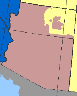
- ArizonaArizonaArizona ; is a state located in the southwestern region of the United States. It is also part of the western United States and the mountain west. The capital and largest city is Phoenix...
and HawaiiHawaiiHawaii is the newest of the 50 U.S. states , and is the only U.S. state made up entirely of islands. It is the northernmost island group in Polynesia, occupying most of an archipelago in the central Pacific Ocean, southwest of the continental United States, southeast of Japan, and northeast of...
use standard time throughout the year. However:- The Navajo NationNavajo NationThe Navajo Nation is a semi-autonomous Native American-governed territory covering , occupying all of northeastern Arizona, the southeastern portion of Utah, and northwestern New Mexico...
observes DST throughout its entire territory, including the portion that lies in Arizona. But the Hopi NationHopi ReservationThe Hopi Reservation, or simply Hopi, is a Native American reservation for the Hopi and Arizona Tewa people, surrounded entirely by the Navajo Nation, in Navajo and Coconino counties of Arizona, USA. The site in north-eastern Arizona has a land area of 2,531.773 sq mi and as of the 2000 census had...
, which is entirely surroundedEnclave and exclaveIn political geography, an enclave is a territory whose geographical boundaries lie entirely within the boundaries of another territory.An exclave, on the other hand, is a territory legally or politically attached to another territory with which it is not physically contiguous.These are two...
by the Navajo Nation, does not observe DST. (See map inset right.)
- The Navajo Nation
- Before 2006, IndianaIndianaIndiana is a US state, admitted to the United States as the 19th on December 11, 1816. It is located in the Midwestern United States and Great Lakes Region. With 6,483,802 residents, the state is ranked 15th in population and 16th in population density. Indiana is ranked 38th in land area and is...
officially used standard time year-round, with the following exceptions:- The portions of Indiana that were on Central Time observed daylight saving time.
- Also, some Indiana counties near Cincinnati and LouisvilleLouisville, KentuckyLouisville is the largest city in the U.S. state of Kentucky, and the county seat of Jefferson County. Since 2003, the city's borders have been coterminous with those of the county because of a city-county merger. The city's population at the 2010 census was 741,096...
were on Eastern Time, but did (unofficially) observe DST. - However, in 2005, Indiana passed legislation which took effect on April 2, 2006, that placed the entire state on daylight saving time. See: Time in IndianaTime in IndianaTime in Indiana refers to the controversial time zone division of Indiana, and to the state's historical response to daylight saving time. The official dividing line between Eastern Time and Central Time has, over time, progressively moved west, from the Indiana–Ohio border, to a position where it...
Tz database
The 27 zones for the United States as given by zone.tab of the tz database. Columns marked * are from the zone.tab.| No. | c.c.* | coordinates* | TZ* | comments* | UTC offset | UTC offset DST | Note |
|---|---|---|---|---|
| 1 | UTC−04 | |||
| 2 | UTC−04 | |||
| 3 | UTC−04 | |||
| 4 | UTC−04 | |||
| 5 | UTC−04 | |||
| 6 | UTC−04 | |||
| 7 | UTC−04 | |||
| 8 | UTC−04 | |||
| 9 | UTC−04 | |||
| 10 | UTC−04 | |||
| 11 | UTC−05 | |||
| 12 | UTC−05 | |||
| 13 | UTC−05 | |||
| 14 | UTC−05 | |||
| 15 | UTC−05 | |||
| 16 | UTC−05 | |||
| 17 | UTC−06 | |||
| 18 | UTC−06 | |||
| 19 | UTC−06 | |||
| 20 | - | |||
| 21 | UTC−07 | |||
| 22 | UTC−08 | |||
| 23 | UTC−08 | |||
| 24 | UTC−08 | |||
| 25 | UTC−08 | |||
| 26 | UTC−09 | |||
| 27 | - |
See also
- History of time in the United States
- Time in IndianaTime in IndianaTime in Indiana refers to the controversial time zone division of Indiana, and to the state's historical response to daylight saving time. The official dividing line between Eastern Time and Central Time has, over time, progressively moved west, from the Indiana–Ohio border, to a position where it...
- List of U.S. states by time zone
- Daylight saving time around the worldDaylight saving time around the worldDaylight saving time around the world, showing usage and a short history by location in alphabetic order, grouped by continent. Most areas of North America and Europe observe daylight saving time , while most areas of Africa and Asia do not...
- Lists of time zones
- Effects of time on North American broadcastingEffects of time on North American broadcastingThe scheduling of television programming in North America must cope with a continent spanning ten time zones: the United States has six time zones , Canada also has six , Mexico has three , Greenland also has...
- Date and time notation in the United StatesDate and time notation in the United States-Date:In the United States, dates are traditionally written in the "month day year" order, that is, in neither descending nor ascending order of significance...
External links
- U.S. Navy time zone page
- North American Time Zone border data and images
- Standard Time Zone Boundaries 49CFR71 (also at :wikisource:Code of Federal Regulations/Title 49/Subtitle A/Part 71)
- Standard Time Law 15USC260-267 (also at :wikisource:United States Code/Title 15/Chapter 6/Subchapter IX)