

Time in Indiana
Encyclopedia
Time in Indiana refers to the controversial time zone
division of Indiana
, and to the state's historical response to daylight saving time
. The official dividing line between Eastern Time
and Central Time has, over time, progressively moved west, from the Indiana–Ohio border, to a position where it divided Indiana down the middle, to the Indiana–Illinois border as it is today.
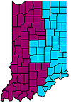
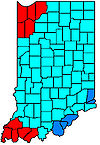
Effective March 9, 2008 with the exception of twelve counties which observe Central Time, Indiana observes Eastern Time. The twelve counties observing Central Time are Jasper
, Lake
, La Porte, Newton
, Porter
, and Starke
in the northwest, near Chicago
, and Gibson
, Perry
, Posey
, Spencer
, Vanderburgh
, and Warrick
in the southwest, near Evansville.
Since April 2, 2006 all counties in Indiana observe daylight saving time.
The most extensive study of time zone history in Indiana has been published in The American Atlas (1978) by Thomas G. Shanks
, where the author identifies 345 distinct areas in the state with different timezone history for each.
The tz database lists 11 time zones for Indiana, where each zone is defined as a geographic area that observed the same offsets from UTC since January 1, 1970 the start of the unix epoch.
Before 1883
Before 1883 in the United States, most towns and cities set their own local time to noon when the sun was at its highest point in the sky. Since the sun reaches "high noon" four minutes later for every degree of longitude traveled towards the west, the time in every town was different. In Indiana, local mean time varied from GMT-5:39 in the east to GMT-5:52 in the west. With the emergence of the railroads, hundreds of miles could be traveled in a much shorter time, allowing a train passenger to experience several slight changes in time over the course of even a short rail trip.
1883
The major railroads in the US agreed to coordinate their clocks and begin operating on "standard time" with four "time zones" established across the nation, centered roughly on the 75th
, 90th
, 105th
, and 120th meridian
s. On November 18, 1883, telegraph lines transmitted GMT
to major cities, where each city was to adjust their official time to their proper zone. The state capital in Indianapolis lies at approximately the 86th meridian
(U.S. Census Bureau), closer to the center of the Central Time Zone at the 90th meridian than the center of the Eastern Time Zone at the 75th meridian.
1918
Time zones first adopted by the United States Congress
with the Standard Time Act of 1918. All of Indiana is located in the Central Time Zone, with the dividing line between Eastern Time and Central time lying on the Indiana–Ohio state line. Daylight saving time
(DST) is included in the original Standard Time Act.
1919
Congress repeals daylight saving time from the Standard Time Act of 1918, though some communities continue to follow it.
1942–1945
Daylight saving time is once again mandated by Congress to conserve energy during World War II
. After the war, the mandate to observe daylight saving time is lifted again.
1949
In a heated rural vs. city debate, the Indiana General Assembly
passes a law to put all of Indiana on Central Standard Time and to outlaw daylight saving time. However, the law has no enforcement power, and it is largely ignored by communities who wish to observe Eastern Standard Time.
1957
The Indiana General Assembly
passes a law to make Central time the official time zone of the state but to permit any community to switch to daylight saving time during the summer. The law did, however, make it illegal for communities to observe "fast time" during the winter months. Governor Handley vows to enforce the law by withdrawing state aid from communities who attempt to observe "fast time" during the winter, though legal obstacles force the Governor to back down from his stance. Once again, the law is not enforceable, as individual communities continue to observe whichever time zone they prefer.
1961
The Indiana legislature
repeals the 1957 law making Central Time the official time of Indiana, which allowed any community to observe DST. The Interstate Commerce Commission divides Indiana between the Central Time Zone and the Eastern Time Zone. The time zone line is not uniformly observed and lack of uniformity of observance of the time zone boundary was compounded by lack of uniform observance of daylight saving time. (See 50 Federal Register 43745 for this account.)
1966
The United States Congress
passes the Uniform Time Act of 1966 to specify where and when daylight saving time is applied in the U.S. Previous to this law, each state was permitted to decide where and when daylight saving time took place. However, with the new federal law, authority over time zones was shifted to the Department of Transportation.
1967
Having the state split in two time zones was inconvenient and so, Governor Roger D. Branigin
petitioned the United States Department of Transportation
(DOT) to place all of Indiana back in the Central Time Zone.
1967–1969
The Department of Transportation conducts several hearings in response to Governor Branigan's petition. Citizens of Northwest and Southwest Indiana appear to favor location in the Central Time Zone with observance of DST, while other citizens favor location in the Eastern Time Zone with no observance of DST.
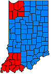
The Department of Transportation divides Indiana between the Central Time Zone and the Eastern Time Zone. Six counties near Chicago
(Lake
, Porter
, LaPorte
, Jasper
, Newton
and Starke) and six counties near Evansville, Indiana
(Posey
, Vanderburgh
, Warrick
, Spencer
, Gibson
and Pike) were placed in the Central Time Zone in observance of DST. The remainder of the state was placed on Eastern Standard Time
throughout the year. The state was given dispensation by the Department of Transportation to exempt parts of itself from DST.
Most portions of the state that were in the Eastern Time Zone did not observe DST. However, some counties (namely Floyd
, Clark
and Harrison
, which are near Louisville, Kentucky
, and Ohio
and Dearborn
, which are near Cincinnati, Ohio) unofficially observed DST due to their proximity to the major cities of Louisville and Cincinnati, and those cities' observance of DST.
1968
While the Department of Transportation
was considering where the time zone line should be, several broadcast companies filed a federal lawsuit to compel the Department to enforce the observance of daylight saving time in Indiana. The Department was ordered to stop informing Indiana residents that the Uniform Time Act will not be enforced and to provide a plan for the enforcement of daylight saving time in Indiana. See Time Life
Broadcast Company, Inc. v. Boyd, 289 F. Supp. 219 (S.D. Indiana, 1968) (Time Life being the then-owner of WFBM-TV
(Channel 6) in Indianapolis).
1972
The Indiana General Assembly
overrides a veto from Governor Whitcomb to place the Northwest and Southwest corners of Indiana in the Central Time Zone on daylight saving time, and to place the rest of the state on Eastern Standard Time, upon federal approval(See IC 1-1-8.1). Congress approves an amendment to the Uniform Time Act of 1966 (15 U.S.C. 260-67) to permit a state that lies in two time zones to exempt part of the state from daylight saving time, and President Richard Nixon
signs it into law. Indiana enacts the statute, officially placing Northwest and Southwest Indiana in the Central Time Zone, in observance of daylight saving time and the rest of the state in the Eastern Standard Time throughout the year. Several Eastern Indiana counties (Ohio and Dearborn counties, near Cincinnati; and Floyd, Clark and Harrison counties, near Louisville) choose to unofficially observe daylight saving time, despite the Indiana statute requiring them to remain on Eastern Standard Time throughout the year.
1977
Pike County
requests to be moved from the Central Time Zone to the Eastern Time Zone. The Department of Transportation
grants the request.
1981
Starke County
requests to be moved from the Central Time Zone to the Eastern Time Zone. The Department of Transportation
did not find a sound reason to change Starke County from the Central Time Zone to the Eastern Time Zone. (See 46 Federal Register 23500; 46 Federal Register 51786)
1985
The Indiana General Assembly
(Senate Concurrent Resolution 6 from 1985) requests the Department of Transportation
to move the five counties in Southwest Indiana (Posey
, Vanderburgh
, Warrick
, Spencer
, and Gibson
) from the Central Time Zone to the Eastern Time Zone. The Department of Transportation
denies the request, finding that the change would not serve the convenience of commerce. (See 50 Federal Register 25856; 50 Federal Register 28959; 50 Federal Register 43745)
1986–1987
Jasper County
and Starke County
petition the Department of Transportation
to be moved from the Central Time Zone to the Eastern Time Zone. The Department of Transportation denies the petitions of both counties. (See 51 Federal Register 43644 and 52 Federal Register 10119)
1991
Things began to change in the 1990s, as Indiana's convoluted time zone situation was seen as impeding the state's economic growth. Interstate travel and commerce were difficult as people wondered, "What time is it in Indiana?"
In 1991, Starke County
petitions the Department of Transportation
to be moved from the Central Time Zone to the Eastern Time Zone. The Department of Transportation grants the petition. Starke County is moved from the Central Time Zone to Eastern Time Zone effective October 27, 1991. (See 56 Federal Register 13609 and 56 Federal Register 51997)
2005
On April 29, 2005, with heavy backing from Governor Mitch Daniels
' economic development plan, and after years of controversy, the Indiana legislature
passed into law that on April 2, 2006, the entire state of Indiana would become the 48th state to observe daylight saving time. The bill was also accompanied by Senate Enrolled Act 127, which required Governor Daniels to seek federal hearings from the United States Department of Transportation
on whether to keep Indiana on Eastern Time with New York
and Ohio
or whether to move the entire state back to Central Time with Chicago
.
2006
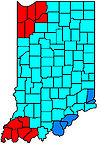
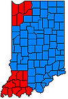
As a result of a review by the Department of Transportation
, eight counties were moved from the Eastern Time Zone to the Central Time Zone, effective April 2, 2006. These were Starke and Pulaski
Counties in the northwest; and Daviess
, Dubois, Knox
, Martin
, Perry
and Pike
Counties in the southwest.
The placement of Martin County into the Central Time Zone, while leaving adjoining Greene and Lawrence Counties in the Eastern Time Zone presented a particular problem for NSWC Crane
, a large US Navy base that straddles all three counties. With the Eastern/Central dividing line running through the base, NSWC Crane was unable to fully comply with the realigned time zones. The base opted to recognize Central Time, since the portion in Martin County was larger than the portions in Greene and Lawrence combined. This decision presented a larger regional problem, for even though NSWC Crane is Martin County's largest employer, two-thirds of the base's employees live in Greene, Lawrence, Monroe
, and other Eastern Time Zone counties. This meant that the vast majority of Crane's employees would live in one time zone but work in another. Furthermore, a business park under construction at Crane's West Gate would straddle the new dividing line, with businesses on one side of the street being in a different time zone than those on the other. After one year under this awkward arrangement, Martin County reconsidered their bid to be placed in the Central Time Zone and formally petitioned for a return to the Eastern Time Zone.
Independent from the situation facing Martin County, Pulaski County also formally petitioned for a return to the Eastern Time Zone. Pulaski County Commissioners and County Council both voted unanimously on February 6, 2006, to declare home rule
and stay on Eastern Time if a federal agency did not grant an appeal to change the time-zone ruling. However, the county conceded on March 27, 2006, officially accepting Central Time and switching time zones on April 2, 2006.
After some residents pledged to unofficially continue observing Eastern Time, the county changed work hours for most county employees so that they were in sync with Eastern Time work hours.
Dubois, Daviess, Knox, and Pike Counties also decided to ask the federal government to return them to the Eastern Time Zone, the former voting to do so on April 27, 2006. The confusion involving the time status of these counties led to their being dubbed the "seesaw six." St. Joseph
, Marshall
and Fulton
counties overtly expressed interest in making another attempt to be changed to Central Time as of the end of 2006".
2007
On February 9, 2007, it was officially reported that the Department of Transportation
had approved Pulaski County
's returning to Eastern Time. The change went into effect on March 11, 2007, the date when daylight saving time resumed.
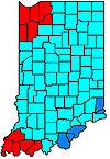
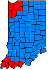
On September 20, 2007, DOT approved a petition from the five southwestern counties Daviess
, Dubois, Knox
, Martin
and Pike
to return to the Eastern Time Zone. The change went into effect when daylight saving time ended on November 3, 2007. A petition from Perry County
to move to the Eastern Time Zone was denied.
With the exception of Perry and Starke counties, all counties that were moved to the Central Time Zone in 2006 were moved back to the Eastern Time Zone in 2007.
With a large agricultural heritage, many farmers oppose DST because their days are controlled by the sun, not the clock. During daylight saving time, the sun rises an hour later, costing farmers sixty minutes of valuable morning productivity. Farmers are often dependent on young children whose parents want them home by dinner, and when the sun is up later in the evening, farmers miss out on recreational activities that only happen late. When the sun is still up at 9pm to 9:30pm, the farmer is still in the field, while others have been off work for hours.
Opponents of putting the entire state on one time zone often cite out-of-state cities as their reason of opposition. For example, counties in Northwestern Indiana are part of the Chicago, Illinois
metropolitan area. Many residents commute to Chicago, which is on Central Time. Counties in the southeastern corner of the state are suburbs of cities such as Cincinnati, Ohio and Louisville, Kentucky
, who both observe Eastern Time. In the southwestern corner of the state, Evansville
serves as the central hub of a tri-state area that includes southern Illinois and western Kentucky (both on Central Time).
Supporters of daylight saving time
(DST) and a common time zone in Indiana often claim Indiana must adopt the time-keeping system of the rest of the nation to preserve business. It is believed that Indiana businesses have lost hours of productive time with out-of-state colleagues because the time quirks are just too confusing to keep track of on a daily basis. The confusion caused to outsiders featured prominently in the plot of an episode of The West Wing in which presidential aides unfamiliar with Indiana's non-observance of DST miss their return flight to Washington, D.C.
, on Air Force One
and express consternation with the variances in the state's time measurement.
Detractors of daylight saving time
point out that scientific studies assessing the impact of the time policy change to DST in Indiana have identified a significant increase in energy usage and spending on electricity by Indiana households. Indiana households paid an additional $8.6 million in electricity bills according to University of California, Santa Barbara
economics professor Matthew Kotchen and Ph.D. student Laura Grant, while supporters of Daylight Saving Time point to studies such as Professor Kotchen, the Department of Transportation and organizations such as the California Energy Commission claim that the United States saves approximately 1% of energy when Daylight Saving Time is being observed.
Another wrinkle in the issue is that some businesses in Indiana still prefer Eastern time to Central time because it is the time zone of Wall Street, despite its geographic location over 700 miles (1,126.5 km) east of Indianapolis. This complicates matters because in the western Indiana counties where Eastern time is observed (South Bend and Fowler south to Terre Haute and Vincennes), around the summer solstice
, the sun neither sets until after 9:20 pm, nor does it reach solar noon until almost 2:00 pm. During the winter months when standard time is observed, school buses in western regions lose a valuable hour of the sun's rays as they pick up children in the morning due to the unnatural geographic location of this Eastern-Time-Zoned region. Another notable observation is that schools in the Eastern Time Zone of Indiana tend to have far more 2-hour delays, mainly due to the fact that sunlight is required for many road de-icing components to work. With the sun rising as late as 8:20 am in some areas, available sunlight is inadequate to safely thaw the roads for school buses to pick up all their passengers on time. The argument is that if the same area were in its geographically natural Central time zone, the sun would be up an hour sooner, and it would have an additional hour to thaw the roads every morning.
-->
Time zone
A time zone is a region on Earth that has a uniform standard time for legal, commercial, and social purposes. In order for the same clock time to always correspond to the same portion of the day as the Earth rotates , different places on the Earth need to have different clock times...
division of Indiana
Indiana
Indiana is a US state, admitted to the United States as the 19th on December 11, 1816. It is located in the Midwestern United States and Great Lakes Region. With 6,483,802 residents, the state is ranked 15th in population and 16th in population density. Indiana is ranked 38th in land area and is...
, and to the state's historical response to daylight saving time
Daylight saving time
Daylight saving time —also summer time in several countries including in British English and European official terminology —is the practice of temporarily advancing clocks during the summertime so that afternoons have more daylight and mornings have less...
. The official dividing line between Eastern Time
Eastern Time Zone
The Eastern Time Zone of the United States and Canada is a time zone that falls mostly along the east coast of North America. Its UTC time offset is −5 hrs during standard time and −4 hrs during daylight saving time...
and Central Time has, over time, progressively moved west, from the Indiana–Ohio border, to a position where it divided Indiana down the middle, to the Indiana–Illinois border as it is today.
Effective March 9, 2008 with the exception of twelve counties which observe Central Time, Indiana observes Eastern Time. The twelve counties observing Central Time are Jasper
Jasper County, Indiana
As of the census of 2000, there were 30,043 people, 10,686 households, and 8,217 families residing in the county. The population density was 54 people per square mile . There were 11,236 housing units at an average density of 20 per square mile...
, Lake
Lake County, Indiana
Lake County is a county located in the U.S. state of Indiana. In 2010, its population was 496,005, making it Indiana's second-most populous county. The county seat is Crown Point. This county is part of Northwest Indiana and the Chicago metropolitan area. The county contains a mix of urban,...
, La Porte, Newton
Newton County, Indiana
Newton County is a county located in the U.S. state of Indiana. As of 2010, the population was 14,244. The county seat is Kentland.- History :...
, Porter
Porter County, Indiana
Porter County is a county located in the U.S. state of Indiana. As of 2010, the population was 164,343. Much of the population growth has to do with the expansion of the Chicago Metropolitan Area eastward into Indiana. The county seat is Valparaiso...
, and Starke
Starke County, Indiana
Starke County is a county located in the U.S. state of Indiana. As of 2010, the population was 23,363. The county seat is Knox.-History:Starke County was created in 1835 and organized in 1850. It was named for Gen...
in the northwest, near Chicago
Chicago
Chicago is the largest city in the US state of Illinois. With nearly 2.7 million residents, it is the most populous city in the Midwestern United States and the third most populous in the US, after New York City and Los Angeles...
, and Gibson
Gibson County, Indiana
Gibson County is a county located in the southwestern part of the U.S. state of Indiana and is included in the Evansville, Indiana–Kentucky Metropolitan Statistical Area. As of 2010, the population was 33,503. The county seat is Princeton.-Geography:...
, Perry
Perry County, Indiana
Perry County is a county located in the southwestern part of the U.S. state of Indiana. As of 2010, the population was 19,338. The county seat is Tell City. It is the hilliest county as well as one of the most forested counties of in Indiana as it features more than of Hoosier National Forest...
, Posey
Posey County, Indiana
As of the census of 2000, there were 27,061 people, 10,205 households, and 7,612 families residing in the county. The population density was 66 people per square mile . There were 11,076 housing units at an average density of 27 per square mile...
, Spencer
Spencer County, Indiana
As of the census of 2000, there were 20,391 people, 7,569 households, and 5,752 families residing in the county. The population density was 51 people per square mile . There were 8,333 housing units at an average density of 21 per square mile...
, Vanderburgh
Vanderburgh County, Indiana
As of the census of 2000, there were 171,922 people, 70,623 households, and 44,421 families residing in the county. The population density was 733 people per square mile . There were 76,300 housing units at an average density of 325 per square mile...
, and Warrick
Warrick County, Indiana
As of the census of 2000, there were 52,383 people, 19,438 households, and 15,181 families residing in the county. The population density was 136 people per square mile . There were 20,546 housing units at an average density of 54 per square mile...
in the southwest, near Evansville.
Since April 2, 2006 all counties in Indiana observe daylight saving time.
The most extensive study of time zone history in Indiana has been published in The American Atlas (1978) by Thomas G. Shanks
Thomas G. Shanks
Thomas G. Shanks is an American computer programmer, author, and time zone history researcher.-Work:While working for a San Diego based astrological computing company as programmer and research director, Shanks did extensive research in the field of worldwide timezone and daylight saving time...
, where the author identifies 345 distinct areas in the state with different timezone history for each.
The tz database lists 11 time zones for Indiana, where each zone is defined as a geographic area that observed the same offsets from UTC since January 1, 1970 the start of the unix epoch.
History
 |
 |
 |
 |
 |
 |
 |
 |
Before 1883
Before 1883 in the United States, most towns and cities set their own local time to noon when the sun was at its highest point in the sky. Since the sun reaches "high noon" four minutes later for every degree of longitude traveled towards the west, the time in every town was different. In Indiana, local mean time varied from GMT-5:39 in the east to GMT-5:52 in the west. With the emergence of the railroads, hundreds of miles could be traveled in a much shorter time, allowing a train passenger to experience several slight changes in time over the course of even a short rail trip.
1883
The major railroads in the US agreed to coordinate their clocks and begin operating on "standard time" with four "time zones" established across the nation, centered roughly on the 75th
75th meridian west
The meridian 75° west of Greenwich is a line of longitude that extends from the North Pole across the Arctic Ocean, North America, the Atlantic Ocean, the Caribbean Sea, South America, the Pacific Ocean, the Southern Ocean, and Antarctica to the South Pole....
, 90th
90th meridian west
The meridian 90° west of Greenwich is a line of longitude that extends from the North Pole across the Arctic Ocean, North America, the Gulf of Mexico, Central America, the Pacific Ocean, the Southern Ocean, and Antarctica to the South Pole....
, 105th
105th meridian west
The meridian 105° west of Greenwich is a line of longitude that extends from the North Pole across the Arctic Ocean, North America, the Pacific Ocean, the Southern Ocean, and Antarctica to the South Pole....
, and 120th meridian
120th meridian west
The meridian 120° west of Greenwich is a line of longitude that extends from the North Pole across the Arctic Ocean, North America, the Pacific Ocean, the Southern Ocean, and Antarctica to the South Pole....
s. On November 18, 1883, telegraph lines transmitted GMT
Greenwich Mean Time
Greenwich Mean Time is a term originally referring to mean solar time at the Royal Observatory in Greenwich, London. It is arguably the same as Coordinated Universal Time and when this is viewed as a time zone the name Greenwich Mean Time is especially used by bodies connected with the United...
to major cities, where each city was to adjust their official time to their proper zone. The state capital in Indianapolis lies at approximately the 86th meridian
86th meridian west
The meridian 86° west of Greenwich is a line of longitude that extends from the North Pole across the Arctic Ocean, North America, the Gulf of Mexico, the Caribbean Sea, Central America, the Pacific Ocean, the Southern Ocean, and Antarctica to the South Pole....
(U.S. Census Bureau), closer to the center of the Central Time Zone at the 90th meridian than the center of the Eastern Time Zone at the 75th meridian.
1918
Time zones first adopted by the United States Congress
United States Congress
The United States Congress is the bicameral legislature of the federal government of the United States, consisting of the Senate and the House of Representatives. The Congress meets in the United States Capitol in Washington, D.C....
with the Standard Time Act of 1918. All of Indiana is located in the Central Time Zone, with the dividing line between Eastern Time and Central time lying on the Indiana–Ohio state line. Daylight saving time
Daylight saving time
Daylight saving time —also summer time in several countries including in British English and European official terminology —is the practice of temporarily advancing clocks during the summertime so that afternoons have more daylight and mornings have less...
(DST) is included in the original Standard Time Act.
1919
Congress repeals daylight saving time from the Standard Time Act of 1918, though some communities continue to follow it.
1942–1945
Daylight saving time is once again mandated by Congress to conserve energy during World War II
World War II
World War II, or the Second World War , was a global conflict lasting from 1939 to 1945, involving most of the world's nations—including all of the great powers—eventually forming two opposing military alliances: the Allies and the Axis...
. After the war, the mandate to observe daylight saving time is lifted again.
1949
In a heated rural vs. city debate, the Indiana General Assembly
Indiana General Assembly
The Indiana General Assembly is the state legislature, or legislative branch, of the state of Indiana. It is a bicameral legislature that consists of a lower house, the Indiana House of Representatives, and an upper house, the Indiana Senate...
passes a law to put all of Indiana on Central Standard Time and to outlaw daylight saving time. However, the law has no enforcement power, and it is largely ignored by communities who wish to observe Eastern Standard Time.
1957
The Indiana General Assembly
Indiana General Assembly
The Indiana General Assembly is the state legislature, or legislative branch, of the state of Indiana. It is a bicameral legislature that consists of a lower house, the Indiana House of Representatives, and an upper house, the Indiana Senate...
passes a law to make Central time the official time zone of the state but to permit any community to switch to daylight saving time during the summer. The law did, however, make it illegal for communities to observe "fast time" during the winter months. Governor Handley vows to enforce the law by withdrawing state aid from communities who attempt to observe "fast time" during the winter, though legal obstacles force the Governor to back down from his stance. Once again, the law is not enforceable, as individual communities continue to observe whichever time zone they prefer.
1961
The Indiana legislature
Indiana General Assembly
The Indiana General Assembly is the state legislature, or legislative branch, of the state of Indiana. It is a bicameral legislature that consists of a lower house, the Indiana House of Representatives, and an upper house, the Indiana Senate...
repeals the 1957 law making Central Time the official time of Indiana, which allowed any community to observe DST. The Interstate Commerce Commission divides Indiana between the Central Time Zone and the Eastern Time Zone. The time zone line is not uniformly observed and lack of uniformity of observance of the time zone boundary was compounded by lack of uniform observance of daylight saving time. (See 50 Federal Register 43745 for this account.)
1966
The United States Congress
United States Congress
The United States Congress is the bicameral legislature of the federal government of the United States, consisting of the Senate and the House of Representatives. The Congress meets in the United States Capitol in Washington, D.C....
passes the Uniform Time Act of 1966 to specify where and when daylight saving time is applied in the U.S. Previous to this law, each state was permitted to decide where and when daylight saving time took place. However, with the new federal law, authority over time zones was shifted to the Department of Transportation.
1967
Having the state split in two time zones was inconvenient and so, Governor Roger D. Branigin
Roger D. Branigin
Roger Douglas Branigin was the 42nd Governor of the U.S. state of Indiana from January 11, 1965 to January 13, 1969...
petitioned the United States Department of Transportation
United States Department of Transportation
The United States Department of Transportation is a federal Cabinet department of the United States government concerned with transportation. It was established by an act of Congress on October 15, 1966, and began operation on April 1, 1967...
(DOT) to place all of Indiana back in the Central Time Zone.
1967–1969
The Department of Transportation conducts several hearings in response to Governor Branigan's petition. Citizens of Northwest and Southwest Indiana appear to favor location in the Central Time Zone with observance of DST, while other citizens favor location in the Eastern Time Zone with no observance of DST.
The Department of Transportation divides Indiana between the Central Time Zone and the Eastern Time Zone. Six counties near Chicago
Chicago
Chicago is the largest city in the US state of Illinois. With nearly 2.7 million residents, it is the most populous city in the Midwestern United States and the third most populous in the US, after New York City and Los Angeles...
(Lake
Lake County, Indiana
Lake County is a county located in the U.S. state of Indiana. In 2010, its population was 496,005, making it Indiana's second-most populous county. The county seat is Crown Point. This county is part of Northwest Indiana and the Chicago metropolitan area. The county contains a mix of urban,...
, Porter
Porter County, Indiana
Porter County is a county located in the U.S. state of Indiana. As of 2010, the population was 164,343. Much of the population growth has to do with the expansion of the Chicago Metropolitan Area eastward into Indiana. The county seat is Valparaiso...
, LaPorte
LaPorte County, Indiana
LaPorte County is a county located in the U.S. state of Indiana. As of 2010, the population was 111,467. The county seat is the city of La Porte. This county is part of the Chicago metropolitan area, Northwest Indiana and Michiana. The largest city is Michigan City...
, Jasper
Jasper County, Indiana
As of the census of 2000, there were 30,043 people, 10,686 households, and 8,217 families residing in the county. The population density was 54 people per square mile . There were 11,236 housing units at an average density of 20 per square mile...
, Newton
Newton County, Indiana
Newton County is a county located in the U.S. state of Indiana. As of 2010, the population was 14,244. The county seat is Kentland.- History :...
and Starke) and six counties near Evansville, Indiana
Evansville, Indiana
Evansville is the third-largest city in the U.S. state of Indiana and the largest city in Southern Indiana. As of the 2010 census, the city had a total population of 117,429. It is the county seat of Vanderburgh County and the regional hub for both Southwestern Indiana and the...
(Posey
Posey County, Indiana
As of the census of 2000, there were 27,061 people, 10,205 households, and 7,612 families residing in the county. The population density was 66 people per square mile . There were 11,076 housing units at an average density of 27 per square mile...
, Vanderburgh
Vanderburgh County, Indiana
As of the census of 2000, there were 171,922 people, 70,623 households, and 44,421 families residing in the county. The population density was 733 people per square mile . There were 76,300 housing units at an average density of 325 per square mile...
, Warrick
Warrick County, Indiana
As of the census of 2000, there were 52,383 people, 19,438 households, and 15,181 families residing in the county. The population density was 136 people per square mile . There were 20,546 housing units at an average density of 54 per square mile...
, Spencer
Spencer County, Indiana
As of the census of 2000, there were 20,391 people, 7,569 households, and 5,752 families residing in the county. The population density was 51 people per square mile . There were 8,333 housing units at an average density of 21 per square mile...
, Gibson
Gibson County, Indiana
Gibson County is a county located in the southwestern part of the U.S. state of Indiana and is included in the Evansville, Indiana–Kentucky Metropolitan Statistical Area. As of 2010, the population was 33,503. The county seat is Princeton.-Geography:...
and Pike) were placed in the Central Time Zone in observance of DST. The remainder of the state was placed on Eastern Standard Time
Eastern Time Zone
The Eastern Time Zone of the United States and Canada is a time zone that falls mostly along the east coast of North America. Its UTC time offset is −5 hrs during standard time and −4 hrs during daylight saving time...
throughout the year. The state was given dispensation by the Department of Transportation to exempt parts of itself from DST.
Most portions of the state that were in the Eastern Time Zone did not observe DST. However, some counties (namely Floyd
Floyd County, Indiana
Floyd County is a county located in the U.S. state of Indiana. As of 2010, the population was 74,578. The county seat is New Albany. Floyd County is the county with the second smallest land area in the entire state...
, Clark
Clark County, Indiana
Clark County is a county located in the U.S. state of Indiana, located directly across the Ohio River from Louisville, Kentucky. At the 2010 Census, the population was 110,232. The county seat is Jeffersonville. Clarksville is also a major city in the county...
and Harrison
Harrison County, Indiana
Harrison County is a county located in the far southern part of the U.S. state of Indiana along the Ohio River. It is divided into twelve townships, and the county seat is Corydon, the former capital of Indiana. The county is part of the larger Louisville/Jefferson County, KY–IN Metropolitan...
, which are near Louisville, Kentucky
Louisville, Kentucky
Louisville is the largest city in the U.S. state of Kentucky, and the county seat of Jefferson County. Since 2003, the city's borders have been coterminous with those of the county because of a city-county merger. The city's population at the 2010 census was 741,096...
, and Ohio
Ohio County, Indiana
As of the census of 2000, there were 5,623 people, 2,201 households, and 1,586 families residing in the county. The population density was 65 people per square mile . There were 2,424 housing units at an average density of 28 per square mile...
and Dearborn
Dearborn County, Indiana
Dearborn County is a county located in the U.S. state of Indiana. As of 2010, the population was 50,047. It is part of the Cincinnati-Northern Kentucky metropolitan area. The county seat is Lawrenceburg.-History:...
, which are near Cincinnati, Ohio) unofficially observed DST due to their proximity to the major cities of Louisville and Cincinnati, and those cities' observance of DST.
1968
While the Department of Transportation
United States Department of Transportation
The United States Department of Transportation is a federal Cabinet department of the United States government concerned with transportation. It was established by an act of Congress on October 15, 1966, and began operation on April 1, 1967...
was considering where the time zone line should be, several broadcast companies filed a federal lawsuit to compel the Department to enforce the observance of daylight saving time in Indiana. The Department was ordered to stop informing Indiana residents that the Uniform Time Act will not be enforced and to provide a plan for the enforcement of daylight saving time in Indiana. See Time Life
Time Inc.
Time Inc. is a subsidiary of the media conglomerate Time Warner, the company formed by the 1990 merger of the original Time Inc. and Warner Communications. It publishes 130 magazines, most notably its namesake, Time...
Broadcast Company, Inc. v. Boyd, 289 F. Supp. 219 (S.D. Indiana, 1968) (Time Life being the then-owner of WFBM-TV
WRTV
WRTV, channel 6, is the ABC television affiliate in Indianapolis, Indiana; it is owned by McGraw-Hill. Its transmitter is located on the northwest side of Indianapolis at 8001 Township Line Road. Its studios are found at 1330 N...
(Channel 6) in Indianapolis).
1972
The Indiana General Assembly
Indiana General Assembly
The Indiana General Assembly is the state legislature, or legislative branch, of the state of Indiana. It is a bicameral legislature that consists of a lower house, the Indiana House of Representatives, and an upper house, the Indiana Senate...
overrides a veto from Governor Whitcomb to place the Northwest and Southwest corners of Indiana in the Central Time Zone on daylight saving time, and to place the rest of the state on Eastern Standard Time, upon federal approval(See IC 1-1-8.1). Congress approves an amendment to the Uniform Time Act of 1966 (15 U.S.C. 260-67) to permit a state that lies in two time zones to exempt part of the state from daylight saving time, and President Richard Nixon
Richard Nixon
Richard Milhous Nixon was the 37th President of the United States, serving from 1969 to 1974. The only president to resign the office, Nixon had previously served as a US representative and senator from California and as the 36th Vice President of the United States from 1953 to 1961 under...
signs it into law. Indiana enacts the statute, officially placing Northwest and Southwest Indiana in the Central Time Zone, in observance of daylight saving time and the rest of the state in the Eastern Standard Time throughout the year. Several Eastern Indiana counties (Ohio and Dearborn counties, near Cincinnati; and Floyd, Clark and Harrison counties, near Louisville) choose to unofficially observe daylight saving time, despite the Indiana statute requiring them to remain on Eastern Standard Time throughout the year.
1977
Pike County
Pike County, Indiana
As of the census of 2000, there were 12,837 people, 5,119 households, and 3,680 families residing in the county. The population density was 38 people per square mile . There were 5,611 housing units at an average density of 17 per square mile...
requests to be moved from the Central Time Zone to the Eastern Time Zone. The Department of Transportation
United States Department of Transportation
The United States Department of Transportation is a federal Cabinet department of the United States government concerned with transportation. It was established by an act of Congress on October 15, 1966, and began operation on April 1, 1967...
grants the request.
1981
Starke County
Starke County, Indiana
Starke County is a county located in the U.S. state of Indiana. As of 2010, the population was 23,363. The county seat is Knox.-History:Starke County was created in 1835 and organized in 1850. It was named for Gen...
requests to be moved from the Central Time Zone to the Eastern Time Zone. The Department of Transportation
United States Department of Transportation
The United States Department of Transportation is a federal Cabinet department of the United States government concerned with transportation. It was established by an act of Congress on October 15, 1966, and began operation on April 1, 1967...
did not find a sound reason to change Starke County from the Central Time Zone to the Eastern Time Zone. (See 46 Federal Register 23500; 46 Federal Register 51786)
1985
The Indiana General Assembly
Indiana General Assembly
The Indiana General Assembly is the state legislature, or legislative branch, of the state of Indiana. It is a bicameral legislature that consists of a lower house, the Indiana House of Representatives, and an upper house, the Indiana Senate...
(Senate Concurrent Resolution 6 from 1985) requests the Department of Transportation
United States Department of Transportation
The United States Department of Transportation is a federal Cabinet department of the United States government concerned with transportation. It was established by an act of Congress on October 15, 1966, and began operation on April 1, 1967...
to move the five counties in Southwest Indiana (Posey
Posey County, Indiana
As of the census of 2000, there were 27,061 people, 10,205 households, and 7,612 families residing in the county. The population density was 66 people per square mile . There were 11,076 housing units at an average density of 27 per square mile...
, Vanderburgh
Vanderburgh County, Indiana
As of the census of 2000, there were 171,922 people, 70,623 households, and 44,421 families residing in the county. The population density was 733 people per square mile . There were 76,300 housing units at an average density of 325 per square mile...
, Warrick
Warrick County, Indiana
As of the census of 2000, there were 52,383 people, 19,438 households, and 15,181 families residing in the county. The population density was 136 people per square mile . There were 20,546 housing units at an average density of 54 per square mile...
, Spencer
Spencer County, Indiana
As of the census of 2000, there were 20,391 people, 7,569 households, and 5,752 families residing in the county. The population density was 51 people per square mile . There were 8,333 housing units at an average density of 21 per square mile...
, and Gibson
Gibson County, Indiana
Gibson County is a county located in the southwestern part of the U.S. state of Indiana and is included in the Evansville, Indiana–Kentucky Metropolitan Statistical Area. As of 2010, the population was 33,503. The county seat is Princeton.-Geography:...
) from the Central Time Zone to the Eastern Time Zone. The Department of Transportation
United States Department of Transportation
The United States Department of Transportation is a federal Cabinet department of the United States government concerned with transportation. It was established by an act of Congress on October 15, 1966, and began operation on April 1, 1967...
denies the request, finding that the change would not serve the convenience of commerce. (See 50 Federal Register 25856; 50 Federal Register 28959; 50 Federal Register 43745)
1986–1987
Jasper County
Jasper County, Indiana
As of the census of 2000, there were 30,043 people, 10,686 households, and 8,217 families residing in the county. The population density was 54 people per square mile . There were 11,236 housing units at an average density of 20 per square mile...
and Starke County
Starke County, Indiana
Starke County is a county located in the U.S. state of Indiana. As of 2010, the population was 23,363. The county seat is Knox.-History:Starke County was created in 1835 and organized in 1850. It was named for Gen...
petition the Department of Transportation
United States Department of Transportation
The United States Department of Transportation is a federal Cabinet department of the United States government concerned with transportation. It was established by an act of Congress on October 15, 1966, and began operation on April 1, 1967...
to be moved from the Central Time Zone to the Eastern Time Zone. The Department of Transportation denies the petitions of both counties. (See 51 Federal Register 43644 and 52 Federal Register 10119)
1991
Things began to change in the 1990s, as Indiana's convoluted time zone situation was seen as impeding the state's economic growth. Interstate travel and commerce were difficult as people wondered, "What time is it in Indiana?"
In 1991, Starke County
Starke County, Indiana
Starke County is a county located in the U.S. state of Indiana. As of 2010, the population was 23,363. The county seat is Knox.-History:Starke County was created in 1835 and organized in 1850. It was named for Gen...
petitions the Department of Transportation
United States Department of Transportation
The United States Department of Transportation is a federal Cabinet department of the United States government concerned with transportation. It was established by an act of Congress on October 15, 1966, and began operation on April 1, 1967...
to be moved from the Central Time Zone to the Eastern Time Zone. The Department of Transportation grants the petition. Starke County is moved from the Central Time Zone to Eastern Time Zone effective October 27, 1991. (See 56 Federal Register 13609 and 56 Federal Register 51997)
2005
On April 29, 2005, with heavy backing from Governor Mitch Daniels
Mitch Daniels
Mitchell Elias "Mitch" Daniels, Jr. is the 49th and current Governor of the U.S. state of Indiana. A Republican, he began his first four-year term as governor on January 10, 2005, and was elected to his second term by an 18-point margin on November 4, 2008. Previously, he was the Director of the...
' economic development plan, and after years of controversy, the Indiana legislature
Indiana General Assembly
The Indiana General Assembly is the state legislature, or legislative branch, of the state of Indiana. It is a bicameral legislature that consists of a lower house, the Indiana House of Representatives, and an upper house, the Indiana Senate...
passed into law that on April 2, 2006, the entire state of Indiana would become the 48th state to observe daylight saving time. The bill was also accompanied by Senate Enrolled Act 127, which required Governor Daniels to seek federal hearings from the United States Department of Transportation
United States Department of Transportation
The United States Department of Transportation is a federal Cabinet department of the United States government concerned with transportation. It was established by an act of Congress on October 15, 1966, and began operation on April 1, 1967...
on whether to keep Indiana on Eastern Time with New York
New York City
New York is the most populous city in the United States and the center of the New York Metropolitan Area, one of the most populous metropolitan areas in the world. New York exerts a significant impact upon global commerce, finance, media, art, fashion, research, technology, education, and...
and Ohio
Ohio
Ohio is a Midwestern state in the United States. The 34th largest state by area in the U.S.,it is the 7th‑most populous with over 11.5 million residents, containing several major American cities and seven metropolitan areas with populations of 500,000 or more.The state's capital is Columbus...
or whether to move the entire state back to Central Time with Chicago
Chicago
Chicago is the largest city in the US state of Illinois. With nearly 2.7 million residents, it is the most populous city in the Midwestern United States and the third most populous in the US, after New York City and Los Angeles...
.
2006
As a result of a review by the Department of Transportation
United States Department of Transportation
The United States Department of Transportation is a federal Cabinet department of the United States government concerned with transportation. It was established by an act of Congress on October 15, 1966, and began operation on April 1, 1967...
, eight counties were moved from the Eastern Time Zone to the Central Time Zone, effective April 2, 2006. These were Starke and Pulaski
Pulaski County, Indiana
As of the census of 2000, there were 13,755 people, 5,170 households, and 3,779 families residing in the county. The population density was 32 people per square mile . There were 5,918 housing units at an average density of 14 per square mile...
Counties in the northwest; and Daviess
Daviess County, Indiana
Daviess County is a county located in the U.S. state of Indiana. As of 2010, the population was 31,648. The county seat is Washington. Daviess County switched to the Central Time Zone on April 2, 2006. It has returned to the Eastern Time Zone as of November 4, 2007.- History :Daviess County was...
, Dubois, Knox
Knox County, Indiana
As of the census of 2000, there were 39,256 people, 15,552 households, and 10,139 families residing in the county. The population density was 76 people per square mile . There were 17,305 housing units at an average density of 34 per square mile...
, Martin
Martin County, Indiana
As of the census of 2000, there were 10,369 people, 4,183 households, and 2,877 families residing in the county. The population density was 31 people per square mile . There were 4,729 housing units at an average density of 14 per square mile...
, Perry
Perry County, Indiana
Perry County is a county located in the southwestern part of the U.S. state of Indiana. As of 2010, the population was 19,338. The county seat is Tell City. It is the hilliest county as well as one of the most forested counties of in Indiana as it features more than of Hoosier National Forest...
and Pike
Pike County, Indiana
As of the census of 2000, there were 12,837 people, 5,119 households, and 3,680 families residing in the county. The population density was 38 people per square mile . There were 5,611 housing units at an average density of 17 per square mile...
Counties in the southwest.
The placement of Martin County into the Central Time Zone, while leaving adjoining Greene and Lawrence Counties in the Eastern Time Zone presented a particular problem for NSWC Crane
Naval Surface Warfare Center Crane Division
Naval Surface Warfare Center Crane Division is the principal tenant command located at Naval Support Activity Crane. NSA Crane is a United States Navy installation located approximately southwest of Bloomington, Indiana and predominantly located in Martin County, but small parts also extend into...
, a large US Navy base that straddles all three counties. With the Eastern/Central dividing line running through the base, NSWC Crane was unable to fully comply with the realigned time zones. The base opted to recognize Central Time, since the portion in Martin County was larger than the portions in Greene and Lawrence combined. This decision presented a larger regional problem, for even though NSWC Crane is Martin County's largest employer, two-thirds of the base's employees live in Greene, Lawrence, Monroe
Monroe County, Indiana
As of the census of 2010, there were 137,974 people, 46,898 households, and 24,715 families residing in the county. The population density was 306 people per square mile . There were 50,846 housing units at an average density of 129 per square mile...
, and other Eastern Time Zone counties. This meant that the vast majority of Crane's employees would live in one time zone but work in another. Furthermore, a business park under construction at Crane's West Gate would straddle the new dividing line, with businesses on one side of the street being in a different time zone than those on the other. After one year under this awkward arrangement, Martin County reconsidered their bid to be placed in the Central Time Zone and formally petitioned for a return to the Eastern Time Zone.
Independent from the situation facing Martin County, Pulaski County also formally petitioned for a return to the Eastern Time Zone. Pulaski County Commissioners and County Council both voted unanimously on February 6, 2006, to declare home rule
Devolution
Devolution is the statutory granting of powers from the central government of a sovereign state to government at a subnational level, such as a regional, local, or state level. Devolution can be mainly financial, e.g. giving areas a budget which was formerly administered by central government...
and stay on Eastern Time if a federal agency did not grant an appeal to change the time-zone ruling. However, the county conceded on March 27, 2006, officially accepting Central Time and switching time zones on April 2, 2006.
After some residents pledged to unofficially continue observing Eastern Time, the county changed work hours for most county employees so that they were in sync with Eastern Time work hours.
Dubois, Daviess, Knox, and Pike Counties also decided to ask the federal government to return them to the Eastern Time Zone, the former voting to do so on April 27, 2006. The confusion involving the time status of these counties led to their being dubbed the "seesaw six." St. Joseph
St. Joseph County, Indiana
As of the census of 2000, there were 265,559 people, 100,743 households, and 66,792 families residing in the county. The population density was 581 people per square mile . There were 107,013 housing units at an average density of 234 per square mile...
, Marshall
Marshall County, Indiana
As of the census of 2000, there were 45,128 people, 16,519 households, and 12,191 families residing in the county. The population density was 102 people per square mile . There were 18,099 housing units at an average density of 41 per square mile...
and Fulton
Fulton County, Indiana
As of the census of 2000, there were 20,511 people, 8,082 households, and 5,738 families residing in the county. The population density was 56 people per square mile . There were 9,123 housing units at an average density of 25 per square mile...
counties overtly expressed interest in making another attempt to be changed to Central Time as of the end of 2006".
2007
On February 9, 2007, it was officially reported that the Department of Transportation
United States Department of Transportation
The United States Department of Transportation is a federal Cabinet department of the United States government concerned with transportation. It was established by an act of Congress on October 15, 1966, and began operation on April 1, 1967...
had approved Pulaski County
Pulaski County, Indiana
As of the census of 2000, there were 13,755 people, 5,170 households, and 3,779 families residing in the county. The population density was 32 people per square mile . There were 5,918 housing units at an average density of 14 per square mile...
's returning to Eastern Time. The change went into effect on March 11, 2007, the date when daylight saving time resumed.
On September 20, 2007, DOT approved a petition from the five southwestern counties Daviess
Daviess County, Indiana
Daviess County is a county located in the U.S. state of Indiana. As of 2010, the population was 31,648. The county seat is Washington. Daviess County switched to the Central Time Zone on April 2, 2006. It has returned to the Eastern Time Zone as of November 4, 2007.- History :Daviess County was...
, Dubois, Knox
Knox County, Indiana
As of the census of 2000, there were 39,256 people, 15,552 households, and 10,139 families residing in the county. The population density was 76 people per square mile . There were 17,305 housing units at an average density of 34 per square mile...
, Martin
Martin County, Indiana
As of the census of 2000, there were 10,369 people, 4,183 households, and 2,877 families residing in the county. The population density was 31 people per square mile . There were 4,729 housing units at an average density of 14 per square mile...
and Pike
Pike County, Indiana
As of the census of 2000, there were 12,837 people, 5,119 households, and 3,680 families residing in the county. The population density was 38 people per square mile . There were 5,611 housing units at an average density of 17 per square mile...
to return to the Eastern Time Zone. The change went into effect when daylight saving time ended on November 3, 2007. A petition from Perry County
Perry County, Indiana
Perry County is a county located in the southwestern part of the U.S. state of Indiana. As of 2010, the population was 19,338. The county seat is Tell City. It is the hilliest county as well as one of the most forested counties of in Indiana as it features more than of Hoosier National Forest...
to move to the Eastern Time Zone was denied.
With the exception of Perry and Starke counties, all counties that were moved to the Central Time Zone in 2006 were moved back to the Eastern Time Zone in 2007.
tz database
Indiana is covered by the following zones in the tz database. Columns marked with * contain the data from zone.tab.EWLINE
|
||||||||||||||||||||||||||||||||||||||||||||||||||||||||||||||||||||||||||||||||||||||||
Controversy
The Indiana time zone debate remains controversial. Many argue that the entire state should move to Central Time, while many others believe the state should return to the non-observance of DST. This controversy is deeply rooted in Indiana.With a large agricultural heritage, many farmers oppose DST because their days are controlled by the sun, not the clock. During daylight saving time, the sun rises an hour later, costing farmers sixty minutes of valuable morning productivity. Farmers are often dependent on young children whose parents want them home by dinner, and when the sun is up later in the evening, farmers miss out on recreational activities that only happen late. When the sun is still up at 9pm to 9:30pm, the farmer is still in the field, while others have been off work for hours.
Opponents of putting the entire state on one time zone often cite out-of-state cities as their reason of opposition. For example, counties in Northwestern Indiana are part of the Chicago, Illinois
Chicago
Chicago is the largest city in the US state of Illinois. With nearly 2.7 million residents, it is the most populous city in the Midwestern United States and the third most populous in the US, after New York City and Los Angeles...
metropolitan area. Many residents commute to Chicago, which is on Central Time. Counties in the southeastern corner of the state are suburbs of cities such as Cincinnati, Ohio and Louisville, Kentucky
Louisville, Kentucky
Louisville is the largest city in the U.S. state of Kentucky, and the county seat of Jefferson County. Since 2003, the city's borders have been coterminous with those of the county because of a city-county merger. The city's population at the 2010 census was 741,096...
, who both observe Eastern Time. In the southwestern corner of the state, Evansville
Evansville, Indiana
Evansville is the third-largest city in the U.S. state of Indiana and the largest city in Southern Indiana. As of the 2010 census, the city had a total population of 117,429. It is the county seat of Vanderburgh County and the regional hub for both Southwestern Indiana and the...
serves as the central hub of a tri-state area that includes southern Illinois and western Kentucky (both on Central Time).
Supporters of daylight saving time
Daylight saving time
Daylight saving time —also summer time in several countries including in British English and European official terminology —is the practice of temporarily advancing clocks during the summertime so that afternoons have more daylight and mornings have less...
(DST) and a common time zone in Indiana often claim Indiana must adopt the time-keeping system of the rest of the nation to preserve business. It is believed that Indiana businesses have lost hours of productive time with out-of-state colleagues because the time quirks are just too confusing to keep track of on a daily basis. The confusion caused to outsiders featured prominently in the plot of an episode of The West Wing in which presidential aides unfamiliar with Indiana's non-observance of DST miss their return flight to Washington, D.C.
Washington, D.C.
Washington, D.C., formally the District of Columbia and commonly referred to as Washington, "the District", or simply D.C., is the capital of the United States. On July 16, 1790, the United States Congress approved the creation of a permanent national capital as permitted by the U.S. Constitution....
, on Air Force One
Air Force One
Air Force One is the official air traffic control call sign of any United States Air Force aircraft carrying the President of the United States. In common parlance the term refers to those Air Force aircraft whose primary mission is to transport the president; however, any U.S. Air Force aircraft...
and express consternation with the variances in the state's time measurement.
Detractors of daylight saving time
Daylight saving time
Daylight saving time —also summer time in several countries including in British English and European official terminology —is the practice of temporarily advancing clocks during the summertime so that afternoons have more daylight and mornings have less...
point out that scientific studies assessing the impact of the time policy change to DST in Indiana have identified a significant increase in energy usage and spending on electricity by Indiana households. Indiana households paid an additional $8.6 million in electricity bills according to University of California, Santa Barbara
University of California, Santa Barbara
The University of California, Santa Barbara, commonly known as UCSB or UC Santa Barbara, is a public research university and one of the 10 general campuses of the University of California system. The main campus is located on a site in Goleta, California, from Santa Barbara and northwest of Los...
economics professor Matthew Kotchen and Ph.D. student Laura Grant, while supporters of Daylight Saving Time point to studies such as Professor Kotchen, the Department of Transportation and organizations such as the California Energy Commission claim that the United States saves approximately 1% of energy when Daylight Saving Time is being observed.
Another wrinkle in the issue is that some businesses in Indiana still prefer Eastern time to Central time because it is the time zone of Wall Street, despite its geographic location over 700 miles (1,126.5 km) east of Indianapolis. This complicates matters because in the western Indiana counties where Eastern time is observed (South Bend and Fowler south to Terre Haute and Vincennes), around the summer solstice
Solstice
A solstice is an astronomical event that happens twice each year when the Sun's apparent position in the sky, as viewed from Earth, reaches its northernmost or southernmost extremes...
, the sun neither sets until after 9:20 pm, nor does it reach solar noon until almost 2:00 pm. During the winter months when standard time is observed, school buses in western regions lose a valuable hour of the sun's rays as they pick up children in the morning due to the unnatural geographic location of this Eastern-Time-Zoned region. Another notable observation is that schools in the Eastern Time Zone of Indiana tend to have far more 2-hour delays, mainly due to the fact that sunlight is required for many road de-icing components to work. With the sun rising as late as 8:20 am in some areas, available sunlight is inadequate to safely thaw the roads for school buses to pick up all their passengers on time. The argument is that if the same area were in its geographically natural Central time zone, the sun would be up an hour sooner, and it would have an additional hour to thaw the roads every morning.
Central Time Coalition
In 2009, the Central Time Coalition was formed, a grassroots organization of businessmen, educators, politicians, and others who like DST but believe that Indiana needs to be restored to its geographically (and historically) correct time zone. Their reasons for restoring Central Time to Indiana include:- Geography. The Eastern Time Zone is based on the time of the line of longitude of 75 degrees west75th meridian westThe meridian 75° west of Greenwich is a line of longitude that extends from the North Pole across the Arctic Ocean, North America, the Atlantic Ocean, the Caribbean Sea, South America, the Pacific Ocean, the Southern Ocean, and Antarctica to the South Pole....
, running east of Columbus, Ohio, while the Central Time Zone is based on 90 degrees west90th meridian westThe meridian 90° west of Greenwich is a line of longitude that extends from the North Pole across the Arctic Ocean, North America, the Gulf of Mexico, Central America, the Pacific Ocean, the Southern Ocean, and Antarctica to the South Pole....
, running through Illinois. All of Indiana is geographically situated in the Central Time Zone.
- Significant cost to education, both in terms of lost hours of education - the common two-hour school delays mentioned above could be reduced to either one-hour delays or even no delays at all (in many cases) with an extra hour of sunlight in the morning, thereby saving the state thousands of dollars in lost education time - and in terms of the safety of school children. According to the Indiana School Bus Drivers Association, since adopting DST (without taking the logical accompanying step of restoring Indiana to the Central Time Zone) in 2006, there has been a marked increase in incidents of school children being hit, injured, and killed by vehicles while walking to school or waiting for buses. Furthermore, the Coalition maintains, morning rush-hour automobile accidents have increased since 2006, due to the unnaturally pitch-black Eastern Time mornings. During the winter months, road chemicals require sunlight to be effective. This causes Indiana to experience dangerous, slippery, dark morning rush hours. On Central Time, afternoon rush hours would darken during the winter (as they do in most other areas of the country), but by then, road chemicals would have had a chance to work. Also, school children would already be home in such a scenario.
- The Indiana business community would also benefit from a realignment with the Central Time Zone for several reasons. First, today's communication is instant, and the old 1950's argument requiring Indiana banks to observe the same time zone as New York banks is now irrelevant. Likewise, businesses no longer require observation of the same time zone as Wall Street. Second, while Indiana businesses conduct more business with those in the Eastern Time Zone, they conduct far more business with the other three time zones combined. With the recent push to promote Indianapolis as a logistics hub, it is imperative that Indiana return to the Central Time Zone. Furthermore, while many Indiana businesses benefit from Indiana's finally observing DST, the Central Time Coalition cannot find any Indiana businesses which benefit from the state's alignment with the Eastern Time Zone versus the Central Time Zone.
See also
- Time in the United StatesTime in the United StatesTime in the United States, by law, is divided into nine standard time zones covering the states and its possessions, with most of the United States observing daylight saving time for part of the year....
- List of counties in Indiana
- America/Indiana/IndianapolisAmerica/Indiana/IndianapolisAmerica/Indiana/Indianapolis is a time zone identifier in the tz database. The data is as follows: The reference point is Indianapolis, the capital and largest city of Indiana.-Covered area:The covered area is most of Indiana....
- Water clock (Indianapolis)Water clock (Indianapolis)The Water Clock, also known as The Giant Water Clock, is in the permanent collection of The Children's Museum of Indianapolis located in Indianapolis, Indiana, United States. The modern water clock is located in the Sunburst Atrium of The Children's Museum, and is adjacent to the Grand Staircase...
External links
- Indiana Time Zone Map 13 KB PDF file is a graphical overview of what counties are on Central and Eastern Time Zones in the State of Indiana.
- Standard Time Zone Boundary in the State of Indiana (a 139 KB PDF file) has some history, public comments from each county, the final DOT determination, and the resulting time zone boundary.
-->