

Sherman County, Kansas
Encyclopedia
Sherman County is a county
located in the U.S. state
of Kansas
. As of the 2010 census, the county population was 6,010. Its county seat
is Goodland
.
, county until the Kansas Constitution was amended in 1986 and voters approved the sale of alcoholic liquor by the individual drink with a 30% food sales requirement.
Sherman County is one of only four Kansas counties to observe Mountain Standard Time. Since Sherman County is part of the Wichita
media market
and the local broadcast stations are repeat signals of Wichita affiliates, prime-time programming in the county is aired from 6 to 9 p.m. local time, rather than 7 to 10 p.m. as is normal in the Central and Mountain time zones. However, cable providers carry the ABC
and NBC
affiliates from both Wichita and Denver
, affording viewers the opportunity to view programs on those networks at the normal prime-time hours.
 As of the census
of 2000, there were 6,760 people, 2,758 households, and 1,781 families residing in the county. The population density
was 6 people per square mile (2/km²). There were 3,184 housing units at an average density of 3 per square mile (1/km²). The racial makeup of the county was 93.83% White
, 0.36% Black
or African American
, 0.33% Native American
, 0.19% Asian
, 0.16% Pacific Islander
, 4.14% from other races
, and 0.99% from two or more races. 8.45% of the population were Hispanic
or Latino
of any race.
There were 2,758 households out of which 29.20% had children under the age of 18 living with them, 55.80% were married couples
living together, 6.00% had a female householder with no husband present, and 35.40% were non-families. 29.20% of all households were made up of individuals and 14.40% had someone living alone who was 65 years of age or older. The average household size was 2.40 and the average family size was 3.00.
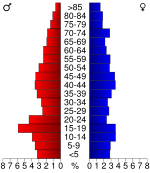
In the county the population was spread out with 24.60% under the age of 18, 11.80% from 18 to 24, 23.90% from 25 to 44, 22.80% from 45 to 64, and 17.10% who were 65 years of age or older. The median age was 38 years. For every 100 females there were 104.50 males. For every 100 females age 18 and over, there were 101.40 males.
The median income for a household in the county was $32,684, and the median income for a family was $38,824. Males had a median income of $28,012 versus $20,927 for females. The per capita income
for the county was $16,761. About 9.70% of families and 12.90% of the population were below the poverty line, including 16.90% of those under age 18 and 7.30% of those age 65 or over.
. The city of Goodland
is considered governmentally independent and is excluded from the census figures for the townships. Georgaphically, Goodland is located at the juncture of Voltaire, Itasca, and Logan Townships. In the following table, the population center is the largest city (or cities) included in that township's population total, if it is of a significant size.
General Information
Maps
County (United States)
In the United States, a county is a geographic subdivision of a state , usually assigned some governmental authority. The term "county" is used in 48 of the 50 states; Louisiana is divided into parishes and Alaska into boroughs. Parishes and boroughs are called "county-equivalents" by the U.S...
located in the U.S. state
U.S. state
A U.S. state is any one of the 50 federated states of the United States of America that share sovereignty with the federal government. Because of this shared sovereignty, an American is a citizen both of the federal entity and of his or her state of domicile. Four states use the official title of...
of Kansas
Kansas
Kansas is a US state located in the Midwestern United States. It is named after the Kansas River which flows through it, which in turn was named after the Kansa Native American tribe, which inhabited the area. The tribe's name is often said to mean "people of the wind" or "people of the south...
. As of the 2010 census, the county population was 6,010. Its county seat
County seat
A county seat is an administrative center, or seat of government, for a county or civil parish. The term is primarily used in the United States....
is Goodland
Goodland, Kansas
Goodland is a city in and the county seat of Sherman County, Kansas, United States. As of the 2010 census, the city population was 4,489.-History:...
.
Law and government
Sherman County was a prohibition, or "dry"Dry county
A dry county is a county in the United States whose government forbids the sale of alcoholic beverages. Some prohibit off-premises sale, some prohibit on-premises sale, and some prohibit both. Hundreds of dry counties exist across the United States, almost all of them in the South...
, county until the Kansas Constitution was amended in 1986 and voters approved the sale of alcoholic liquor by the individual drink with a 30% food sales requirement.
Geography
According to the 2000 census, the county has a total area of 1056.01 square miles (2,735.1 km²), of which 1055.8 square miles (2,734.5 km²) (or 99.98%) is land and 0.21 square mile (0.5438975031 km²) (or 0.02%) is water.Sherman County is one of only four Kansas counties to observe Mountain Standard Time. Since Sherman County is part of the Wichita
Wichita, Kansas
Wichita is the largest city in the U.S. state of Kansas.As of the 2010 census, the city population was 382,368. Located in south-central Kansas on the Arkansas River, Wichita is the county seat of Sedgwick County and the principal city of the Wichita metropolitan area...
media market
Media market
A media market, broadcast market, media region, designated market area , Television Market Area , or simply market is a region where the population can receive the same television and radio station offerings, and may also include other types of media including newspapers and Internet content...
and the local broadcast stations are repeat signals of Wichita affiliates, prime-time programming in the county is aired from 6 to 9 p.m. local time, rather than 7 to 10 p.m. as is normal in the Central and Mountain time zones. However, cable providers carry the ABC
American Broadcasting Company
The American Broadcasting Company is an American commercial broadcasting television network. Created in 1943 from the former NBC Blue radio network, ABC is owned by The Walt Disney Company and is part of Disney-ABC Television Group. Its first broadcast on television was in 1948...
and NBC
NBC
The National Broadcasting Company is an American commercial broadcasting television network and former radio network headquartered in the GE Building in New York City's Rockefeller Center with additional major offices near Los Angeles and in Chicago...
affiliates from both Wichita and Denver
Denver, Colorado
The City and County of Denver is the capital and the most populous city of the U.S. state of Colorado. Denver is a consolidated city-county, located in the South Platte River Valley on the western edge of the High Plains just east of the Front Range of the Rocky Mountains...
, affording viewers the opportunity to view programs on those networks at the normal prime-time hours.
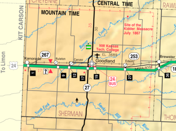
Adjacent counties
- Cheyenne CountyCheyenne County, KansasCheyenne County is a county located in Northwest Kansas, in the Central United States. As of the 2010 census, the county population was 2,726. Its county seat and most populous city is St...
(north) - Rawlins CountyRawlins County, KansasRawlins County is a county located in the U.S. state of Kansas. As of the 2010 census, the county population was 2,519. The largest city and county seat is Atwood...
(northeast) - Thomas CountyThomas County, KansasThomas County is a county located in the U.S. state of Kansas. As of the 2010 census, the county population was 7,900...
(east) - Logan CountyLogan County, KansasLogan County is a county located in the U.S. state of Kansas. As of the 2010 census, the county population was 2,756...
(southeast) - Wallace CountyWallace County, KansasWallace County is a county located in the U.S. state of Kansas. As of the 2010 census, the county population was 1,485. It has the second lowest population of any county in Kansas. Greeley County has the lowest. Its county seat is Sharon Springs. It was created in 1868 and named in honor of...
(south) - Kit Carson CountyKit Carson County, ColoradoKit Carson County is the 18th most extensive of the 64 counties of the State of Colorado of the United States. The county population was 8,011 at U.S. Census 2000. The county was named for Kit Carson...
, ColoradoColoradoColorado is a U.S. state that encompasses much of the Rocky Mountains as well as the northeastern portion of the Colorado Plateau and the western edge of the Great Plains...
(west)
Major highways
-
 Interstate 70
 -
 US-24
US-24 -
 K-27K-27 (Kansas highway)K-27 is a long north–south state highway that parallels Kansas' western border with Colorado. It begins in Elkhart at the Oklahoma state line and travels through the seven counties that border Colorado until reaching its northern terminus in Cheyenne County north of St...
Demographics
Census
A census is the procedure of systematically acquiring and recording information about the members of a given population. It is a regularly occurring and official count of a particular population. The term is used mostly in connection with national population and housing censuses; other common...
of 2000, there were 6,760 people, 2,758 households, and 1,781 families residing in the county. The population density
Population density
Population density is a measurement of population per unit area or unit volume. It is frequently applied to living organisms, and particularly to humans...
was 6 people per square mile (2/km²). There were 3,184 housing units at an average density of 3 per square mile (1/km²). The racial makeup of the county was 93.83% White
Race (United States Census)
Race and ethnicity in the United States Census, as defined by the Federal Office of Management and Budget and the United States Census Bureau, are self-identification data items in which residents choose the race or races with which they most closely identify, and indicate whether or not they are...
, 0.36% Black
Race (United States Census)
Race and ethnicity in the United States Census, as defined by the Federal Office of Management and Budget and the United States Census Bureau, are self-identification data items in which residents choose the race or races with which they most closely identify, and indicate whether or not they are...
or African American
Race (United States Census)
Race and ethnicity in the United States Census, as defined by the Federal Office of Management and Budget and the United States Census Bureau, are self-identification data items in which residents choose the race or races with which they most closely identify, and indicate whether or not they are...
, 0.33% Native American
Race (United States Census)
Race and ethnicity in the United States Census, as defined by the Federal Office of Management and Budget and the United States Census Bureau, are self-identification data items in which residents choose the race or races with which they most closely identify, and indicate whether or not they are...
, 0.19% Asian
Race (United States Census)
Race and ethnicity in the United States Census, as defined by the Federal Office of Management and Budget and the United States Census Bureau, are self-identification data items in which residents choose the race or races with which they most closely identify, and indicate whether or not they are...
, 0.16% Pacific Islander
Race (United States Census)
Race and ethnicity in the United States Census, as defined by the Federal Office of Management and Budget and the United States Census Bureau, are self-identification data items in which residents choose the race or races with which they most closely identify, and indicate whether or not they are...
, 4.14% from other races
Race (United States Census)
Race and ethnicity in the United States Census, as defined by the Federal Office of Management and Budget and the United States Census Bureau, are self-identification data items in which residents choose the race or races with which they most closely identify, and indicate whether or not they are...
, and 0.99% from two or more races. 8.45% of the population were Hispanic
Race (United States Census)
Race and ethnicity in the United States Census, as defined by the Federal Office of Management and Budget and the United States Census Bureau, are self-identification data items in which residents choose the race or races with which they most closely identify, and indicate whether or not they are...
or Latino
Race (United States Census)
Race and ethnicity in the United States Census, as defined by the Federal Office of Management and Budget and the United States Census Bureau, are self-identification data items in which residents choose the race or races with which they most closely identify, and indicate whether or not they are...
of any race.
There were 2,758 households out of which 29.20% had children under the age of 18 living with them, 55.80% were married couples
Marriage
Marriage is a social union or legal contract between people that creates kinship. It is an institution in which interpersonal relationships, usually intimate and sexual, are acknowledged in a variety of ways, depending on the culture or subculture in which it is found...
living together, 6.00% had a female householder with no husband present, and 35.40% were non-families. 29.20% of all households were made up of individuals and 14.40% had someone living alone who was 65 years of age or older. The average household size was 2.40 and the average family size was 3.00.
In the county the population was spread out with 24.60% under the age of 18, 11.80% from 18 to 24, 23.90% from 25 to 44, 22.80% from 45 to 64, and 17.10% who were 65 years of age or older. The median age was 38 years. For every 100 females there were 104.50 males. For every 100 females age 18 and over, there were 101.40 males.
The median income for a household in the county was $32,684, and the median income for a family was $38,824. Males had a median income of $28,012 versus $20,927 for females. The per capita income
Per capita income
Per capita income or income per person is a measure of mean income within an economic aggregate, such as a country or city. It is calculated by taking a measure of all sources of income in the aggregate and dividing it by the total population...
for the county was $16,761. About 9.70% of families and 12.90% of the population were below the poverty line, including 16.90% of those under age 18 and 7.30% of those age 65 or over.
Incorporated cities
Name and population (2004 estimate):- GoodlandGoodland, KansasGoodland is a city in and the county seat of Sherman County, Kansas, United States. As of the 2010 census, the city population was 4,489.-History:...
, 4,534 (county seat) - KanoradoKanorado, KansasKanorado is a city in Sherman County, Kansas, United States. The name is a portmanteau of Kansas and Colorado. As of the 2010 census, the city population was 153.-Geography:Kanorado is located at...
, 230
Townships
Sherman County is divided into thirteen townshipsCivil township
A civil township is a widely used unit of local government in the United States, subordinate to, and geographic divisions of, a county. Specific responsibilities and the degree of autonomy vary based on each state. Civil townships are distinct from survey townships, but in states that have both,...
. The city of Goodland
Goodland, Kansas
Goodland is a city in and the county seat of Sherman County, Kansas, United States. As of the 2010 census, the city population was 4,489.-History:...
is considered governmentally independent and is excluded from the census figures for the townships. Georgaphically, Goodland is located at the juncture of Voltaire, Itasca, and Logan Townships. In the following table, the population center is the largest city (or cities) included in that township's population total, if it is of a significant size.
| Township | FIPS | Population center |
Population | Population density /km² (/sq mi) |
Land area km² (sq mi) | Water area km² (sq mi) | Water % | Geographic coordinates |
|---|---|---|---|---|---|---|---|---|
| Grant Grant Township, Sherman County, Kansas Grant Township is one of the thirteen townships of Sherman County, Kansas, United States. The population was 115 at the 2000 census.-Geography:Located in the northwestern corner of the county, along the Colorado border, it borders the following townships:... |
28150 | 115 | 0 (1) | 355 (137) | 0 (0) | 0.02% | 39°28′26"N 101°54′41"W | |
| Iowa Iowa Township, Sherman County, Kansas Iowa Township is one of the thirteen townships of Sherman County, Kansas, United States. The population was 44 at the 2000 census.-Geography:Located in the southeastern corner of the county, it borders the following townships:*Washington Township — north... |
34450 | 44 | 0 (0) | 279 (108) | 0 (0) | 0 % | 39°15′27"N 101°29′38"W | |
| Itasca Itasca Township, Sherman County, Kansas Itasca Township is one of the thirteen townships of Sherman County, Kansas, United States. The population was 321 at the 2000 census.-Geography:Located in the center of the county, it borders the following townships:*Voltaire Township — north... |
34600 | 321 | 4 (10) | 87 (34) | 0 (0) | 0 % | 39°19′33"N 101°40′29"W | |
| Lincoln Lincoln Township, Sherman County, Kansas Lincoln Township is one of the thirteen townships of Sherman County, Kansas, United States. The population was 95 at the 2000 census.-Geography:Located in the western part of the county, it borders the following townships:*Grant Township — north... |
41175 | 95 | 1 (1) | 186 (72) | 0 (0) | 0.03% | 39°19′5"N 101°53′3"W | |
| Llanos Llanos Township, Sherman County, Kansas Llanos Township is one of the thirteen townships of Sherman County, Kansas, United States. The population was 43 at the 2000 census.-Geography:Located in the northeastern corner of the county, it borders the following townships:... |
41650 | 43 | 0 (1) | 185 (71) | 0 (0) | 0 % | 39°28′31"N 101°28′29"W | |
| Logan Logan Township, Sherman County, Kansas Logan Township is one of the thirteen townships of Sherman County, Kansas, United States. The population was 246 at the 2000 census.-Geography:Located in the center of the county, it borders the following townships:*Voltaire Township — north... |
42250 | 246 | 2 (5) | 138 (53) | 0 (0) | 0 % | 39°19′15"N 101°46′55"W | |
| McPherson McPherson Township, Sherman County, Kansas McPherson Township is one of the thirteen townships of Sherman County, Kansas, United States. The population was 52 at the 2000 census.-Geography:... |
44025 | 52 | 0 (1) | 174 (67) | 0 (0) | 0 % | 39°10′18"N 101°56′12"W | |
| Shermanville Shermanville Township, Sherman County, Kansas Shermanville Township is one of the thirteen townships of Sherman County, Kansas, United States. The population was 51 at the 2000 census.-Geography:Located in the northern part of the county, it borders the following townships:... |
65175 | 51 | 0 (1) | 185 (71) | 0 (0) | 0 % | 39°29′54"N 101°34′25"W | |
| Smoky Smoky Township, Sherman County, Kansas Smoky Township is one of the thirteen townships of Sherman County, Kansas, United States. The population was 87 at the 2000 census.-Geography:Located in the southern part of the county, it borders the following townships:... |
65950 | 87 | 0 (1) | 280 (108) | 0 (0) | 0.12% | 39°11′48"N 101°46′11"W | |
| Stateline Stateline Township, Sherman County, Kansas Stateline Township is one of the thirteen townships of Sherman County, Kansas, United States. The population was 344 at the 2000 census.-Geography:Located in the western part of the county, along the Colorado border, it borders the following townships:... |
68150 | Kanorado Kanorado, Kansas Kanorado is a city in Sherman County, Kansas, United States. The name is a portmanteau of Kansas and Colorado. As of the 2010 census, the city population was 153.-Geography:Kanorado is located at... |
344 | 2 (5) | 165 (64) | 0 (0) | 0.03% | 39°19′6"N 102°0′17"W |
| Union Union Township, Sherman County, Kansas Union Township is one of the thirteen townships of Sherman County, Kansas, United States. The population was 56 at the 2000 census.-Geography:Located in the eastern part of the county, it borders the following townships:*Llanos Township — north... |
72425 | 56 | 0 (1) | 140 (54) | 0 (0) | 0 % | 39°20′25"N 101°27′24"W | |
| Voltaire Voltaire Township, Sherman County, Kansas Voltaire Township is one of the thirteen townships of Sherman County, Kansas, United States. The population was 252 at the 2000 census.-Geography:Located in the northern part of the county, it borders the following townships:... |
74175 | 252 | 1 (2) | 411 (159) | 0 (0) | 0 % | 39°27′12"N 101°43′4"W | |
| Washington Washington Township, Sherman County, Kansas Washington Township is one of the thirteen townships of Sherman County, Kansas, United States. The population was 106 at the 2000 census.-Geography:Located in the eastern part of the county, it borders the following townships:... |
75750 | 106 | 1 (2) | 139 (54) | 0 (0) | 0 % | 39°20′0"N 101°32′59"W |
Education
Unified school districts
Further reading
- History of the State of Kansas; William G. Cutler; A.T. Andreas Publisher; 1883. (Online HTML eBook)
- Kansas : A Cyclopedia of State History, Embracing Events, Institutions, Industries, Counties, Cities, Towns, Prominent Persons, Etc; 3 Volumes; Frank W. Blackmar; Standard Publishing Co; 944 / 955 / 824 pages; 1912. (Volume1 - Download 54MB PDF eBook),(Volume2 - Download 53MB PDF eBook), (Volume3 - Download 33MB PDF eBook)
External links
OfficialGeneral Information
Maps
- Sherman County Map, KDOT
- Kansas Highway Map, KDOT
- Kansas Railroad Map, KDOT
- Kansas School District Boundary Map, KSDE