
.gif)
Lunar distance (navigation)
Encyclopedia
Celestial navigation
Celestial navigation, also known as astronavigation, is a position fixing technique that has evolved over several thousand years to help sailors cross oceans without having to rely on estimated calculations, or dead reckoning, to know their position...
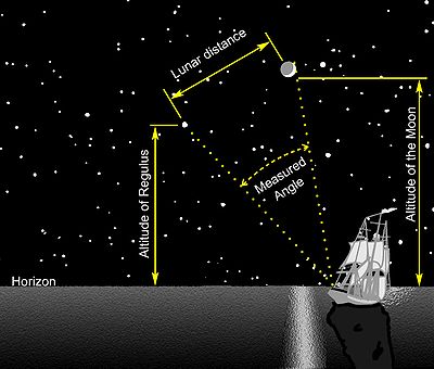
, lunar distance is the angle between the Moon
Moon
The Moon is Earth's only known natural satellite,There are a number of near-Earth asteroids including 3753 Cruithne that are co-orbital with Earth: their orbits bring them close to Earth for periods of time but then alter in the long term . These are quasi-satellites and not true moons. For more...
and another celestial body
Celestial Body
Celestial Body is a Croatian film directed by Lukas Nola. It was released in 2000....
. A navigator
Navigator
A navigator is the person on board a ship or aircraft responsible for its navigation. The navigator's primary responsibility is to be aware of ship or aircraft position at all times. Responsibilities include planning the journey, advising the Captain or aircraft Commander of estimated timing to...
can use a lunar distance (also called a lunar) and a nautical almanac
Nautical almanac
A nautical almanac is a publication describing the positions of a selection of celestial bodies for the purpose of enabling navigators to use celestial navigation to determine the position of their ship while at sea...
to calculate Greenwich time
Greenwich Mean Time
Greenwich Mean Time is a term originally referring to mean solar time at the Royal Observatory in Greenwich, London. It is arguably the same as Coordinated Universal Time and when this is viewed as a time zone the name Greenwich Mean Time is especially used by bodies connected with the United...
. The navigator can then determine longitude
Longitude
Longitude is a geographic coordinate that specifies the east-west position of a point on the Earth's surface. It is an angular measurement, usually expressed in degrees, minutes and seconds, and denoted by the Greek letter lambda ....
without a marine chronometer
Marine chronometer
A marine chronometer is a clock that is precise and accurate enough to be used as a portable time standard; it can therefore be used to determine longitude by means of celestial navigation...
.
The reason for measuring lunar distances
In celestial navigationCelestial navigation
Celestial navigation, also known as astronavigation, is a position fixing technique that has evolved over several thousand years to help sailors cross oceans without having to rely on estimated calculations, or dead reckoning, to know their position...
, precise knowledge of the time at Greenwich
Greenwich
Greenwich is a district of south London, England, located in the London Borough of Greenwich.Greenwich is best known for its maritime history and for giving its name to the Greenwich Meridian and Greenwich Mean Time...
and the positions of one or more celestial objects are combined with careful observations to calculate latitude
Latitude
In geography, the latitude of a location on the Earth is the angular distance of that location south or north of the Equator. The latitude is an angle, and is usually measured in degrees . The equator has a latitude of 0°, the North pole has a latitude of 90° north , and the South pole has a...
and longitude
Longitude
Longitude is a geographic coordinate that specifies the east-west position of a point on the Earth's surface. It is an angular measurement, usually expressed in degrees, minutes and seconds, and denoted by the Greek letter lambda ....
. Reliable marine chronometer
Marine chronometer
A marine chronometer is a clock that is precise and accurate enough to be used as a portable time standard; it can therefore be used to determine longitude by means of celestial navigation...
s were unavailable until the late 18th century and not affordable until the 19th century. For approximately one hundred years (from about 1767 until about 1850) mariners lacking a chronometer used the method of lunar distances to determine Greenwich time, an important step in finding their longitude. A mariner with a chronometer could check and correct its reading using a lunar determination of Greenwich time.
Summary
The method relies on the relatively quick movement of the moon across the background sky, completing a circuit of 360 degrees in 27.3 days. In an hour then, it will move about half a degree, roughly its own diameterAngular diameter
The angular diameter or apparent size of an object as seen from a given position is the “visual diameter” of the object measured as an angle. In the vision sciences it is called the visual angle. The visual diameter is the diameter of the perspective projection of the object on a plane through its...
, with respect to the background stars and the Sun. Using a sextant
Sextant
A sextant is an instrument used to measure the angle between any two visible objects. Its primary use is to determine the angle between a celestial object and the horizon which is known as the altitude. Making this measurement is known as sighting the object, shooting the object, or taking a sight...
, the navigator precisely measures the angle between the moon and another body
Celestial Body
Celestial Body is a Croatian film directed by Lukas Nola. It was released in 2000....
. That could be the Sun or one of a selected group of bright stars lying close to the Moon's path, near the ecliptic
Ecliptic
The ecliptic is the plane of the earth's orbit around the sun. In more accurate terms, it is the intersection of the celestial sphere with the ecliptic plane, which is the geometric plane containing the mean orbit of the Earth around the Sun...
. At that moment, anyone on the surface of the earth who can see the same two bodies will observe the same angle (after correcting for parallax
Parallax
Parallax is a displacement or difference in the apparent position of an object viewed along two different lines of sight, and is measured by the angle or semi-angle of inclination between those two lines. The term is derived from the Greek παράλλαξις , meaning "alteration"...
error). The navigator then consults a prepared table of lunar distances and the times at which they will occur.
By comparing the corrected lunar distance with the tabulated values, the navigator finds the Greenwich time for that observation.
Knowing Greenwich time and local time, the navigator can work out longitude.
Local time can be determined from a sextant observation of the altitude of the Sun or a star. Then the longitude (relative to Greenwich) is readily calculated from the difference between local time and Greenwich Time, at 15 degrees per hour.
In Practice
Having measured the lunar distance and the heights of the two bodies, the navigator can find Greenwich time in three steps.Step One – Preliminaries
- Almanac tables predict lunar distances between the centre of the Moon and the other body (see any nautical almanac from 1767 to c.1900). However, the observer cannot accurately find the centre of the Moon (and Sun, which was the most frequently used second object). Instead, lunar distances are always measured to the sharply lit, outer edge ("limb") of the Moon and from the sharply defined limb of the Sun. The first correction to the lunar distance is the distance between the limb of the Moon and its center. Since the Moon's apparent size varies with its varying distance from the Earth, almanacs give the Moon's and Sun's semidiameter for each day (see any nautical almanac from the period). Additionally the observed altitudes are cleared of dip and semidiameter.
Step Two – Clearing
- Clearing the lunar distance means correcting for the effects of parallax and atmospheric refraction on the observation. The almanac gives lunar distances as they would appear if the observer were at the center of a transparent Earth. Because the Moon is so much closer to the Earth than the stars are, the position of the observer on the surface of the Earth shifts the relative position of the Moon by up to an entire degree. The clearing correction for parallax and refraction is a relatively simple trigonometric function of the observed lunar distance and the altitudes of the two bodies. Navigators used collections of mathematical tables to work these calculations by any of dozens of distinct clearing methods.
Step Three – Finding the Time
- The navigator, having cleared the lunar distance, now consults a prepared table of lunar distances and the times at which they will occur in order to determine the Greenwich time of the observation.
Having found the (absolute) Greenwich time, the navigator either compares it with the observed local apparent time (a separate observation) to find longitude or compares it with the Greenwich time on a chronometer if one is available.
Errors
Effect of Lunar Distance Errors on calculated Longitude- A lunar distance changes with time at a rate of roughly half a degree, or 30 arc-minutes, in an hour. Therefore, an error of half an arc-minute will give rise to an error of about 1 minute in Greenwich Time, which (owing to the Earth rotating at 15 degrees per hour) is the same as one quarter degree in longitude (about 15 nmi (27.8 km) at the equator).
Almanac error
- In the early days of lunars, predictions of the Moon's position were good to approximately half an arc-minute, a source of error of up to approximately 1 minute in Greenwich time, or one quarter degree of longitude. By 1810, the errors in the almanac predictions had been reduced to about one-quarter of a minute of arc. By about 1860 (after lunar distance observations had mostly faded into history), the almanac errors were finally reduced to less than the error margin of a sextant in ideal conditions (one-tenth of a minute of arc).
Lunar distance observation
- The best sextantSextantA sextant is an instrument used to measure the angle between any two visible objects. Its primary use is to determine the angle between a celestial object and the horizon which is known as the altitude. Making this measurement is known as sighting the object, shooting the object, or taking a sight...
s at the very beginning of the lunar distance era could indicate angle to one-sixth of a minute and later sextants (after c. 1800) measure angles with a precision of 0.1 minutes of arc, after the use of the nonius or vernierVernierVernier may refer to:Secondary adjustment devices for forms of "fine tuning":*Vernier scale on measuring instruments*Vernier thruster, on spacecraft*Vernier throttle, on aircraft*Vernier sight, on target riflesPeople:...
was popularized by its description in English in the book Navigatio Britannica published in 1750 by John BarrowJohn Barrow-People:*John Barrow , 18th century English historian*John Barrow , a British geographical compiler. His principal work was A Chronological Abridgment or History of the Discoveries made by Europeans in the different parts of the world *Sir John Barrow, 1st Baronet , English statesman*John Henry...
, the mathematician and historian. In practice at sea, actual errors were somewhat larger. Experienced observers can typically measure lunar distances to within one-quarter of a minute of arc under favourable conditions, introducing an error of up to one quarter degree in longitude. Needless to say, if the sky is cloudy or the Moon is "New" (hidden close to the glare of the Sun), lunar distance observations could not be performed.
Total Error
- The two sources of error, combined, typically amount to about one-half arc-minute in Lunar distance, equivalent to one minute in Greenwich time, which corresponds to an error of as much as one-quarter of a degree of Longitude, or about 15 nautical miles (27.8 km) at the equator.
In literature
Captain Joshua SlocumJoshua Slocum
Joshua Slocum was the first man to sail single-handedly around the world. He was a Canadian born, naturalised American seaman and adventurer, and a noted writer. In 1900 he told the story of this in Sailing Alone Around the World...
, in making the first solo circumnavigation
Circumnavigation
Circumnavigation – literally, "navigation of a circumference" – refers to travelling all the way around an island, a continent, or the entire planet Earth.- Global circumnavigation :...
in 1895-1898, somewhat anachronistically used the lunar method along with dead reckoning
Dead reckoning
In navigation, dead reckoning is the process of calculating one's current position by using a previously determined position, or fix, and advancing that position based upon known or estimated speeds over elapsed time, and course...
in his navigation
Navigation
Navigation is the process of monitoring and controlling the movement of a craft or vehicle from one place to another. It is also the term of art used for the specialized knowledge used by navigators to perform navigation tasks...
. He comments in Sailing Alone Around the World
Sailing Alone Around the World
Sailing Alone Around the World is a sailing memoir by Joshua Slocum about his single-handed global circumnavigation aboard the sloop Spray. Slocum was the first person to sail around the world alone...
on a sight taken in the South Pacific
Pacific Ocean
The Pacific Ocean is the largest of the Earth's oceanic divisions. It extends from the Arctic in the north to the Southern Ocean in the south, bounded by Asia and Australia in the west, and the Americas in the east.At 165.2 million square kilometres in area, this largest division of the World...
. After correcting an error he found in his log tables, the result was surprisingly accurate:
I found from the result of three observations, after long wrestling with lunar tables, that her longitude agreed within five miles of that by dead-reckoning.
This was wonderful; both, however, might be in error, but somehow I felt confident that both were nearly true, and that in a few hours more I should see land; and so it happened, for then I made out the island of Nukahiva, the southernmost of the Marquesas group, clear-cut and lofty. The verified longitude when abreast was somewhere between the two reckonings; this was extraordinary. All navigators will tell you that from one day to another a ship may lose or gain more than five miles in her sailing-account, and again, in the matter of lunars, even expert lunarians are considered as doing clever work when they average within eight miles of the truth...
The result of these observations naturally tickled my vanity, for I knew it was something to stand on a great ship’s deck and with two assistants take lunar observations approximately near the truth. As one of the poorest of American sailors, I was proud of the little achievement alone on the sloop, even by chance though it may have been...
The work of the lunarian, though seldom practised in these days of chronometers, is beautifully edifying, and there is nothing in the realm of navigation that lifts one’s heart up more in adoration.
See also
- Royal Greenwich Observatory 1675
- Nautical almanacNautical almanacA nautical almanac is a publication describing the positions of a selection of celestial bodies for the purpose of enabling navigators to use celestial navigation to determine the position of their ship while at sea...
- Nevil MaskelyneNevil MaskelyneThe Reverend Dr Nevil Maskelyne FRS was the fifth English Astronomer Royal. He held the office from 1765 to 1811.-Biography:...
- John HarrisonJohn HarrisonJohn Harrison was a self-educated English clockmaker. He invented the marine chronometer, a long-sought device in solving the problem of establishing the East-West position or longitude of a ship at sea, thus revolutionising and extending the possibility of safe long distance sea travel in the Age...
- Board of LongitudeBoard of LongitudeThe Board of Longitude was the popular name for the Commissioners for the Discovery of the Longitude at Sea. It was a British Government body formed in 1714 to administer a scheme of prizes intended to encourage innovators to solve the problem of finding longitude at sea.-Origins:Navigators and...
1714 - Longitude prizeLongitude prizeThe Longitude Prize was a reward offered by the British government for a simple and practical method for the precise determination of a ship's longitude...
1714 - Henry RaperHenry RaperHenry Raper was a British Royal Naval lieutenant who became a nineteenth-century authority on navigation. Amongst his achievements was his quantification of the unreliability of a key longitudinal measurement, lunar distance, when taken at different times...
- American Practical Navigator
- Carry On, Mr. BowditchCarry On, Mr. BowditchCarry On, Mr. Bowditch is a novel by Jean Lee Latham that was awarded the Newbery Medal in 1956.The book is a children's biography of Nathaniel Bowditch, a sailor and mathematician who published the mammoth and comprehensive reference work for seamen: The American Practical Navigator...