
List of aerial tramways
Encyclopedia
List of aerial tramway
s (US) or cable car
s (Europe) around the world.
(Note: this list should not contain gondola lifts.)
NIGERIA
A cable car was installed by Doppelmayr of Switzerland in 2005 from the base to the top of Obudu Ranch Resort in Cross River State of Nigeria
Among 170 aerial lifts in Japan, 73 lines are aerial tramways, including 1 funitel. 69 aerial tramways operate full season. See the above article for the full listing of aerial lifts in the country (including gondola lifts). Some notable aerial tramways include:
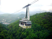
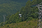
“Tatev wings” aerial tramway is supported by three towers between its two terminals. One terminal is on a hill overlooking the village of Halidzor
and the other is near Tatev Monastery, on the road to Tatev village. At top speed, the tramway travels at 37 kilometers per hour and the ride takes approximately 11 minutes, with its deepest drop at 360 meters aboveground. Two cabins (each with the capacity to hold 25 people) operate at once, traveling in opposite directions. There are six cables altogether (three per cabin, with two cables suspending and one cable pulling each cabin), each uniquely built for the specifications of this project. They are capable of carrying 10-15 times more than the nominal load. The tramway is equipped with a diesel drive unit which will operate immediately in the case of a power outage.
Portugal - madiera cable car
The cable car at Zell am See in the Austrian Alps is but one of 55 aerial tramways, gondolas and chair lifts in this location alone. Cable cars of all types carry an estimated 500- to 550-million passengers each year in Austria.
Aerial tramway
An aerial tramway , cable car , ropeway or aerial tram is a type of aerial lift which uses one or two stationary ropes for support while a third moving rope provides propulsion...
s (US) or cable car
Cable car
A cable car is any of a variety of transportation systems relying on cables to pull vehicles along or lower them at a steady rate, or a vehicle on these systems.-Aerial lift:Aerial lifts where the vehicle is suspended in the air from a cable:...
s (Europe) around the world.
- For gondola liftGondola liftA gondola lift is a type of aerial lift, normally called a cable car, which is supported and propelled by cables from above. It consists of a loop of steel cable that is strung between two stations, sometimes over intermediate supporting towers. The cable is driven by a bullwheel in a terminal,...
s, see the List of gondola lifts. - For funitels, see the FunitelFunitelA funitel is a type of aerial lift, generally used to transport skiers. The name funitel is a portmanteau between the French words funiculaire and telepherique. Funitels have not only been used as a means to transport skiers; there is one used to transport finished cars between different areas of...
article.
(Note: this list should not contain gondola lifts.)
 South Africa
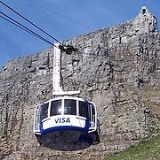
- The Table Mountain Aerial CablewayTable Mountain Aerial CablewayThe Table Mountain Aerial Cableway is a cableway to the top of Table Mountain in Cape Town, South Africa. It is one of Cape Town's most popular tourist attractions with approximately 800,000 people a year using the cableway. On the 29 December 2004 the cableway passed its 16 millionth visitor.The...
, to summit of Table Mountain, Cape TownCape TownCape Town is the second-most populous city in South Africa, and the provincial capital and primate city of the Western Cape. As the seat of the National Parliament, it is also the legislative capital of the country. It forms part of the City of Cape Town metropolitan municipality...
.
NIGERIA
A cable car was installed by Doppelmayr of Switzerland in 2005 from the base to the top of Obudu Ranch Resort in Cross River State of Nigeria
 People's Republic of China
- ChongqingChongqingChongqing is a major city in Southwest China and one of the five national central cities of China. Administratively, it is one of the PRC's four direct-controlled municipalities , and the only such municipality in inland China.The municipality was created on 14 March 1997, succeeding the...
An aerial tramway provides transportation across the Yangtse River. The tramway is 740 m long and operates at 8 m/s. Each cabin can carry a maximum of 45 passengers, with a total design capacity of 900 passengers /hour in each direction.
 India
India
- GangtokGangtokGangtok is the capital and largest town of the Indian state of Sikkim. Gangtok is located in the Shivalik Hills of the eastern Himalayan range, at an altitude of . The town, with a population of thirty thousand belonging to different ethnicities such as Nepalis, Lepchas and Bhutia, is administered...
– A ropeway is in operation in the eastern Himalayan town of Gangtok. The ropeway ferries tourists from one part of the city to another. - Phelagham – in this ski resort in Jammu and KashmirJammu and KashmirJammu and Kashmir is the northernmost state of India. It is situated mostly in the Himalayan mountains. Jammu and Kashmir shares a border with the states of Himachal Pradesh and Punjab to the south and internationally with the People's Republic of China to the north and east and the...
, the cable cars ferry passengers up the ski slopes. - VisakhapatnamVisakhapatnamVisakhapatnam is a major sea port on the south east coast of India. With a population of approximately 1.7 million, it is the second largest city in the state of Andhra Pradesh and the third largest city on the east coast of India after Kolkata and Chennai. According to the history, the city was...
– Design and installation of a 800 PPH capacity, 350 m long Passenger Ropeway at Kailash Giri, Visakhapatnam on BOOT basis built by Conveyor & Ropeway Services Pvt. Ltd. - Bhopal – Design, supply, erection, commissioning, operation and maintenance of a 400 PPH capacity, 600 M long Passenger Ropeway on BOOT basis, at Bheraghat, Marble Rocks, Jabalpur, M.P. is under execution. The project is awarded by Conveyor & Ropeway Services Pvt. Ltd.
- Darjiling – Revamping of an existing 100 PPD capacity Passenger Ropeway and converting it into 2000 PPD capacity, 2.3 km long, Detachable Grip type, Six-Seater, multi-cabin. GondoIa, taking full Operation & Maintenance control. A Joint Venture WIth West Bengal Forest Development Corporation Limited on Built-Own-Operate (BOO) basis by Conveyor & Ropeway Services Pvt. Ltd.
 Iran
Iran
- Ganjnameh Cable Car in Hamedan province of Iran is situated in an archaeological site belonging to the Sassanid era.
- Tochal TelecabinTochal ComplexTochal Complex is consisted of many recreational and sports facilities located in Velenjak, North of Tehran.-Tochal Telecabin :Tochal Telecabin is probably the world's longest gondola lift lines with a length of 7500 m.. The project started in 1974 and has been open to the public since 1978...
in TehranTehranTehran , sometimes spelled Teheran, is the capital of Iran and Tehran Province. With an estimated population of 8,429,807; it is also Iran's largest urban area and city, one of the largest cities in Western Asia, and is the world's 19th largest city.In the 20th century, Tehran was subject to...
province of Iran is situated in VelenjakVelenjakVelenjak is a neighbourhood, northwest of Tehran, in Iran.- About :Located in the Shemiran area in the northernmost part of Tehran, on the slopes of the Alborz mountain range, Valenjak is known for its beautiful landscape, mild climate, fresh mountain air, springs, and wildlife.Velenjak is located...
, north of Tehran. 7.5 km and one of the world longest cable car's line.
- NamakabroodNamakabroodNamakabrood is a touristic village in the Mazandaran province of Iran. Namak abrood has an aerial tramway which starts at the sea level near the shores of the Caspian Sea and ends on the top of the Alborz heights crossing dense forest area of northern Iran. There are numerous villa cities around...
telecabin in Mazandaran province of Iran.
- LahijanLahijanLahijan is a city in and the capital of Lahijan County, Gilan Province, Iran. At the 2006 census, its population was 71,871, in 21,518 families....
telecabin in Guilan province of Iran.
 Israel
- The Masada cablewayMasada cablewayThe Masada cableway is an aerial tramway at the ancient fortress of Masada, Israel. Its bottom station is 257 m below and its summit station is 33 metres above sea level, thereby making it the lowest aerial tramway in the world....
which lifts visitors from well below sea levelSea levelMean sea level is a measure of the average height of the ocean's surface ; used as a standard in reckoning land elevation...
up to the butteButteA butte is a conspicuous isolated hill with steep, often vertical sides and a small, relatively flat top; it is smaller than mesas, plateaus, and table landform tables. In some regions, such as the north central and northwestern United States, the word is used for any hill...
where the ancient Jewish fortress townTownA town is a human settlement larger than a village but smaller than a city. The size a settlement must be in order to be called a "town" varies considerably in different parts of the world, so that, for example, many American "small towns" seem to British people to be no more than villages, while...
's ruins can be seen. The only other way up is a snake path. - The Rosh HaNikra grottoesRosh HaNikra grottoesRosh HaNikra is a geologic formation in Israel, located on the coast of the Mediterranean Sea, in the Western Galilee. It is a white chalk cliff face which opens up into spectacular grottos....
cableway which takes visitors down to the grottoes carved by the Mediterranean SeaMediterranean SeaThe Mediterranean Sea is a sea connected to the Atlantic Ocean surrounded by the Mediterranean region and almost completely enclosed by land: on the north by Anatolia and Europe, on the south by North Africa, and on the east by the Levant...
. - The Stella MarisStella MarisStella Maris may refer to* Polaris * A title of the Blessed Virgin Mary, known in English as Our Lady, Star of the Seaplaces or organizations named for the Virgin Mary:...
cableway in HaifaHaifaHaifa is the largest city in northern Israel, and the third-largest city in the country, with a population of over 268,000. Another 300,000 people live in towns directly adjacent to the city including the cities of the Krayot, as well as, Tirat Carmel, Daliyat al-Karmel and Nesher...
which lifts people from the Mediterranean coast to the top of Mount CarmelMount CarmelMount Carmel ; , Kármēlos; , Kurmul or جبل مار إلياس Jabal Mar Elyas 'Mount Saint Elias') is a coastal mountain range in northern Israel stretching from the Mediterranean Sea towards the southeast. Archaeologists have discovered ancient wine and oil presses at various locations on Mt. Carmel...
.
 Japan
Japan
Among 170 aerial lifts in Japan, 73 lines are aerial tramways, including 1 funitel. 69 aerial tramways operate full season. See the above article for the full listing of aerial lifts in the country (including gondola lifts). Some notable aerial tramways include:
- The Awashima Kaijō RopewayAwashima Kaijo RopewayThe is Japanese aerial lift line in Numazu, Shizuoka, operated by . On , the former deserted island off shore Numazu, Awashima Marine Park developed the resort with the same name, which includes a hotel and a public aquarium. The aerial lift line links Honshū and the island, across the short strait...
, NumazuNumazu, Shizuokais a city located in eastern Shizuoka Prefecture, Japan. As of 2009, the city has an estimated population of 205,636 and a population density of 1,100 persons per km². The total area was 187.11 km².- Geography:...
, ShizuokaShizuoka Prefectureis a prefecture of Japan located in the Chūbu region on Honshu island. The capital is the city of Shizuoka.- History :Shizuoka prefecture was formed from the former Tōtōmi, Suruga and Izu provinces.The area was the home of the first Tokugawa Shogun...
, is the first line in the country to go over the sea. - The Komagatake RopewayKomagatake Ropewayis an aerial lift line in Nagano Prefecture, Japan. This is the only line operates. The company, a member of Meitetsu Group, also operates hotels and ski resorts. The line, opened in 1967, climbs...
, NaganoNagano Prefectureis a prefecture of Japan located in the Chūbu region of the island of Honshū. The capital is the city of Nagano.- History :Nagano was formerly known as the province of Shinano...
, has the station with the highest altitude in Japan, 2,611 m (8,568 ft). - The Mt. Aso RopewayMt. Aso RopewayThe is Japanese aerial lift line in Aso, Kumamoto, operated by . Opened in 1958. the line clims Mount Aso. Its official website claims it was the first aerial lift in the world to be built on an active volcano...
, AsoAso, Kumamotois a city located in Kumamoto Prefecture, Japan.The city was formed on February 11, 2005 from the merger of the former town of Aso with the town of Ichinomiya, and the village of Namino, all from Aso District....
, KumamotoKumamoto Prefectureis a prefecture of Japan located on Kyushu Island. The capital is the city of Kumamoto.- History :Historically the area was called Higo Province; and the province was renamed Kumamoto during the Meiji Restoration. The creation of prefectures was part of the abolition of the feudal system...
, is one of the few aerial lifts in the world on an active volcano. - The Miyajima RopewayMiyajima RopewayThe refers to Japanese aerial lift lines in Hatsukaichi, Hiroshima. This is the only route operates. The company is a subsidiary of Hiroshima Electric Railway. The route, consisted of two lines, climbs Mount Misen of Miyajima Island. It opened in 1959...
, HatsukaichiHatsukaichi, Hiroshimais a city of some 120,000 people located in Hiroshima Prefecture, Japan. The name derives from a market traditionally held on the 20th of each month with hatsuka meaning "20th day" and ichi translating to "market"...
, HiroshimaHiroshima Prefectureis a prefecture of Japan located in the Chūgoku region on Honshu island. The capital is the city of Hiroshima.- History :The area around Hiroshima was formerly divided into Bingo Province and Aki Province. This location has been a center of trade and culture since the beginning of Japan's recorded...
, in the holy island of MiyajimaItsukushimais an island in the western part of the Inland Sea of Japan, located in the northwest of Hiroshima Bay. It is popularly known as , the Shrine Island. The island is one of . Itsukushima is part of the city of Hatsukaichi in Hiroshima Prefecture...
. - The Mt. Hakodate RopewayMt. Hakodate RopewayThe is the name of an aerial lift, as well as its operator. The line climbs Mount Hakodate in Hakodate, Japan. As of 2004, this is the most heavily used aerial lift line in Japan, transporting 1,559,000 riders yearly...
, HakodateHakodate, Hokkaidois a city and port located in Oshima Subprefecture, Hokkaido, Japan. It is the capital city of Oshima Subprefecture.Hakodate was Japan's first city whose port was opened to foreign trade in 1854 as a result of Convention of Kanagawa, and used to be the most important port in northern Japan...
, HokkaidōHokkaido, formerly known as Ezo, Yezo, Yeso, or Yesso, is Japan's second largest island; it is also the largest and northernmost of Japan's 47 prefectural-level subdivisions. The Tsugaru Strait separates Hokkaido from Honshu, although the two islands are connected by the underwater railway Seikan Tunnel...
, is the most popular aerial lift line in Japan, in terms of ridership. It was featured in NoeinNoein, also known simply as Noein, is a science fiction anime television series directed by Kazuki Akane and Kenji Yasuda and produced by Satelight...
, 2005 animeAnimeis the Japanese abbreviated pronunciation of "animation". The definition sometimes changes depending on the context. In English-speaking countries, the term most commonly refers to Japanese animated cartoons....
. - The Ryuoo RopewayRyuoo RopewayThe is Japanese aerial lift line in Yamanouchi, Nagano, operated by . The company also operates , in which the aerial lift runs. Opened in 1961, the line mainly transports skiers in winter, but also hikers in other seasons.-Basic data:...
, YamanouchiYamanouchi, Naganois a town located in Shimotakai District, Nagano, Japan.As of 2003, the town has an estimated population of 15,326 and a density of 57.63 persons per km². The total area is 265.93 km².The Shiga Kōgen ski resort is located in Yamanouchi.-Landmarks:...
, NaganoNagano Prefectureis a prefecture of Japan located in the Chūbu region of the island of Honshū. The capital is the city of Nagano.- History :Nagano was formerly known as the province of Shinano...
, uses the largest cabins in Japan with 166 passenger capacity. - The Yuzawa Kōgen RopewayYuzawa Kogen RopewayThe , officially the , is Japanese aerial lift line in Yuzawa, Niigata, operated by . The line runs in the town of the huge ski resort complex, but it also transports hikers in other seasons...
, YuzawaYuzawa, Niigatais an onsen town located in Minamiuonuma District in the mountains of the Chuetsu region of Niigata Prefecture, Japan.-Demographics:...
, NiigataNiigata Prefectureis a prefecture of Japan located on the island of Honshū on the coast of the Sea of Japan. The capital is the city of Niigata. The name "Niigata" literally means "new lagoon".- History :...
, also uses cabins with 166 passenger capacity. - The Shinhotaka RopewayShinhotaka RopewayThe is an aerial lift system in Takayama, Gifu Prefecture, Japan, and is operated by . The Meitetsu Group company also operates hotels in the area. Opened in 1970, the line climbs to the hillside of the Hida Mountains' Mount Hotaka, the third tallest mountain in Japan.-Basic data:The Shinhotaka...
, TakayamaTakayama, Gifuis a city located in Gifu, Japan. As of July, 2011 the city has an estimated population of 92,369. The total area is .Takayama was settled as far back as the Jōmon period. Takayama is best known for its inhabitants' expertise in carpentry. It is believed carpenters from Takayama worked on the...
, GifuGifu Prefectureis a prefecture located in the Chūbu region of central Japan. Its capital is the city of Gifu.Located in the center of Japan, it has long played an important part as the crossroads of Japan, connecting the east to the west through such routes as the Nakasendō...
, is the first line in the country to use double decker cabins. - The Tateyama RopewayTateyama RopewayThe is Japanese aerial lift line in Tateyama, Toyama, operated by Tateyama Kurobe Kankō. The line, opened in 1970, makes a part of Tateyama Kurobe Alpine Route...
, TateyamaTateyama, Toyamais a town located in Nakaniikawa District, Toyama, Japan.As of 2003, the town has an estimated population of 28,123 and a density of 91.51 persons per km². The total area is 307.31 km².-External links:*...
, ToyamaToyama Prefectureis a prefecture of Japan located in the Hokuriku region on Honshū island. The capital is the city of Toyama.Toyama is the leading industrial prefecture on the Japan Sea coast, and has the industrial advantage of cheap electricity due to abundant water resources....
, makes a part of the Tateyama Kurobe Alpine RouteTateyama Kurobe Alpine RouteThe is a famous mountain sightseeing route between Tateyama, Toyama and Ōmachi, Nagano, Japan. The whole route opened on June 1, 1971.-Overview:The route is just 37 km in length, but the vertical interval is as large as 1,975m...
. - The Unpenji RopewayUnpenji RopewayThe is Japanese aerial lift line in Kan'onji, Kagawa, operated by Shikoku Cable. Opened in 1987, the line climbs to Unpen-ji, the 66th temple of Shikoku Pilgrimage. The temple is at the highest altitude point of the entire pilgrimage...
, Kan'onjiKan'onji, Kagawais a city located in Kagawa, Japan.As of May 1, 2011, the city has an estimated population of 63,721, with households 23,480 and a density of 542.44 persons per km². The total area is 117.45 km²....
, KagawaKagawa Prefectureis a prefecture of Japan located on Shikoku island. The capital is Takamatsu.- History :Kagawa was formerly known as Sanuki Province.For a brief period between August 1876 and December 1888, Kagawa was made a part of Ehime Prefecture.-Battle of Yashima:...
, is the fastest line (10 m/sMetre per secondMetre per second is an SI derived unit of both speed and velocity , defined by distance in metres divided by time in seconds....
) in Japan. It also has the longet span in the country, 1.9 km (1.2 mi). - The Yoshino RopewayYoshino RopewayThe is an aerial tramway in Mount Yoshino, Yoshino, Nara, Japan, operated by Yoshino Ōmine Kēburu Ropeway Bus Co., Ltd. This is the oldest surviving aerial lift line in the nation. The line opened on March 12, 1929, a year after Yoshino Railway, the current Kintetsu Yoshino Line, opened the...
, YoshinoYoshino, Narais a town located in Yoshino District, Nara Prefecture, Japan.As of September 1, 2007, the town had an estimated population of 9397 and a density of 97.93 persons per km². The total area was 95.65 km².-Geography:...
, NaraNara Prefectureis a prefecture in the Kansai region on Honshū Island, Japan. The capital is the city of Nara.-History:The present-day Nara Prefecture was created in 1887, making it independent of Osaka Prefecture....
, is the oldest surviving line in Japan, opened in 1929.
 Lebanon
- The TeleferiqueTéléphérique (Jounieh)The Téléphérique, owned and operated by Compagnie Libanaise du Telepherique et d' Expansion Touristique SAL, is a gondola lift, a cable-car system located in Jounieh, a city in Lebanon 16 km north of Beirut...
connects the bay of JouniehJouniehJounieh is a Mediterranean coastal city about 16 kilometers north of Beirut, Lebanon. Jounieh is known for its seaside resorts, pubs, restaurants and nightclubs, as well as its old stone souk, ferry, and cablecar , which takes passengers up the mountain to the shrine of Our Lady of Lebanon in...
, a city 16 km north of the capital BeirutBeirutBeirut is the capital and largest city of Lebanon, with a population ranging from 1 million to more than 2 million . Located on a peninsula at the midpoint of Lebanon's Mediterranean coastline, it serves as the country's largest and main seaport, and also forms the Beirut Metropolitan...
, to HarissaHarissa, LebanonHarissa is a mountain village in Lebanon. The village, which is located 650 meters above sea level, is home to an important Lebanese pilgrimage site, Our Lady of Lebanon. The village is located 20 km north of Beirut Beirut, and it accessible from the coastal city of Jounieh either by road...
's Our Lady of LebanonOur Lady of LebanonOur Lady of Lebanon , also known as Notre Dame du Liban, is a marian shrine and a pilgrimage site, honoring the patron saint of the Mediterranean country of Lebanon. The Lebanese Christians as well as the Druze and Muslims have a special devotion to the Blessed Virgin Mary...
pilgrimage monument at about 650 meters above sea level. It is 1,570 meters long and travels at 3.15 meters/second.
 Malaysia
- Genting SkywayGenting SkywayGenting Skyway is a gondola lift serving the Genting Highlands Resort on Genting Highlands. It is located at the Kuala Kubu Bharu, Selangor side of Genting Highlands. Its lower station located near Gohtong Jaya, about 51 kilometres North-East of Kuala Lumpur, comprises a 5-storey station building...
serves the hilltop resort of Genting HighlandsGenting HighlandsGenting Highlands otherwise known as Resorts World Genting is the flagship integrated resort developed by Genting Group. It is nestled on a mountain peak within the Titiwangsa Mountains on the border between the states of Pahang and Selangor of Malaysia... - The Awana skyway, connects the Awana Country club resort to the hilltop resort of Genting HighlandsGenting HighlandsGenting Highlands otherwise known as Resorts World Genting is the flagship integrated resort developed by Genting Group. It is nestled on a mountain peak within the Titiwangsa Mountains on the border between the states of Pahang and Selangor of Malaysia...
. - Penang Cable Car, connects Teluk BahangTeluk BahangTeluk Bahang is a fishing village situated on the northwestern part of Penang Island in Malaysia. The Teluk Bahang Dam is situated here. Teluk Bahang is also the entry point for the Penang National Park, which was previously known as the Pantai Aceh Forest Reserve.The expensive Mutiara Beach Resort...
in PenangPenangPenang is a state in Malaysia and the name of its constituent island, located on the northwest coast of Peninsular Malaysia by the Strait of Malacca. It is bordered by Kedah in the north and east, and Perak in the south. Penang is the second smallest Malaysian state in area after Perlis, and the...
island to the hill resort of Penang HillPenang HillPenang Hill is a hill resort comprising a group of peaks in Penang, Malaysia. It is located in Air Itam, which is from the city centre of George Town. The hill stands out prominently from the lowlands as a hilly and forested area...
. Construction is expected to start in 2006 and it will be the 2nd longest in the world.
 South Korea
- Namsan cable carNamsan cable carNamsan cable car is an aerial tramway in Seoul. Built in 1962, it spans from the Hoehyeon-dong platform to the Yejang-dong platform near the top of Mt. Namsan and the N Seoul Tower. It is the first commercial cable car service for passengers in Korea.The length of the cable is 605 metres. The...
, SeoulSeoulSeoul , officially the Seoul Special City, is the capital and largest metropolis of South Korea. A megacity with a population of over 10 million, it is the largest city proper in the OECD developed world...
. - Sorak Cable Car, Sokcho City, Kangwon-do, connects to Kwongeum castle in SORAKSAN NATIONAL PARK.
 Armenia
- “Tatevi tever” (“Tatev wings”) at the villages Halidzor and TatevTatevThe Monastery of Tatev is a 9th century Armenian monastery located in the Tatev village in Syunik Province in southern Armenia. The term "Tatev" usually refers to the monastery. It stands on a plateau on the edge of the deep gorge of the Orotan River...
, Syuniq region -Spanning 5.7 kilometers across the spectacular Vorotan River Gorge, the Tatev Aerial Tramway - the longest passenger aerial tramway in the world.
“Tatev wings” aerial tramway is supported by three towers between its two terminals. One terminal is on a hill overlooking the village of Halidzor
Halidzor
Halidzor is a village and rural community in the Syunik Province of Armenia. The Halidzor Fortress is nearby. The National Statistical Service of the Republic of Armenia reported its population was 707 in 2010, up from 602 at the 2001 census.The village hosts a station of the Wings of Tatev -...
and the other is near Tatev Monastery, on the road to Tatev village. At top speed, the tramway travels at 37 kilometers per hour and the ride takes approximately 11 minutes, with its deepest drop at 360 meters aboveground. Two cabins (each with the capacity to hold 25 people) operate at once, traveling in opposite directions. There are six cables altogether (three per cabin, with two cables suspending and one cable pulling each cabin), each uniquely built for the specifications of this project. They are capable of carrying 10-15 times more than the nominal load. The tramway is equipped with a diesel drive unit which will operate immediately in the case of a power outage.
Portugal - madiera cable car
 Austria
- This sub-section is under development.
The cable car at Zell am See in the Austrian Alps is but one of 55 aerial tramways, gondolas and chair lifts in this location alone. Cable cars of all types carry an estimated 500- to 550-million passengers each year in Austria.
- Gletscherbahn Kaprun IIIGlacial Aerial Tramway Kaprun IIIThe Glacial Aerial Tramway Kaprun III is the third section of the aerial tramway on the Kitzsteinhorn mountain at Kaprun, Austria. It was placed in service on 26 November 1966....
- aerial tramway with tallest aerial lift pylon in the world (height: 113.6 metres) - Tyrolean Zugspitze Cable Car
 Early Modern France
- The Téléphérique de l'Aiguille du MidiAiguille du MidiThe Aiguille du Midi is a mountain in the Mont Blanc massif in the French Alps.The cable car to the summit, the Téléphérique de l'Aiguille du Midi, was built in 1955 and held the title of the world's highest cable car for about two decades. It still holds the record as the highest vertical ascent...
, opened in 1955, can carry 75 passengers in the first section and 65 passengers in the second section. It starts in ChamonixChamonixChamonix-Mont-Blanc or, more commonly, Chamonix is a commune in the Haute-Savoie département in the Rhône-Alpes region in south-eastern France. It was the site of the 1924 Winter Olympics, the first Winter Olympics...
at the altitude of 1030 m to Plan de l'Aiguille at 2317 m for the first section. The second section arrives at the top of the Aiguille du MidiAiguille du MidiThe Aiguille du Midi is a mountain in the Mont Blanc massif in the French Alps.The cable car to the summit, the Téléphérique de l'Aiguille du Midi, was built in 1955 and held the title of the world's highest cable car for about two decades. It still holds the record as the highest vertical ascent...
in a station at 3777 m high. - Vallee Blanche Aerial TramwayVallee Blanche Aerial TramwayThe Vallée Blanche Aerial Tramway or Funivia dei Ghiacciai or Télécabine Panoramic Mont-Blanc, is a passenger aerial tramway between Courmayeur and Chamonix by passing over the Mont Blanc Massif, in the Alps. The project was by Vittorio Zignoli of Polytechnic University of Turin...
using a special support structure for its ropeRopeA rope is a length of fibres, twisted or braided together to improve strength for pulling and connecting. It has tensile strength but is too flexible to provide compressive strength...
s. - The Vanoise Express, opened in December 2003 at a cost of €EuroThe euro is the official currency of the eurozone: 17 of the 27 member states of the European Union. It is also the currency used by the Institutions of the European Union. The eurozone consists of Austria, Belgium, Cyprus, Estonia, Finland, France, Germany, Greece, Ireland, Italy, Luxembourg,...
15 million, is a double-deckerAerial tramwayAn aerial tramway , cable car , ropeway or aerial tram is a type of aerial lift which uses one or two stationary ropes for support while a third moving rope provides propulsion...
tramway for 200 passengers in each car. It spans the Ponturin gorge at a height of 380 m (1250 ft) above the ground, linking the resorts of La PlagneLa PlagneLa Plagne is a French ski area in the alpine valley of the Tarentaise . Since 2003, La Plagne and the neighbouring resort of Les Arcs form Paradiski's ski area...
and Les ArcsLes ArcsLes Arcs is a ski resort located in Savoie, France, in the Tarentaise Valley town of Bourg-Saint-Maurice. Initially created by Robert Blanc and Roger Godino...
in four minutes to form the ParadiskiParadiskiParadiski is a ski-area in the Tarentaise Valley offering uninterrupted skiing in between the areas of Les Arcs, Peisey-Vallandry and La Plagne. The area is linked, since December 2003, by the Vanoise Express...
ski resortSki resortA ski resort is a resort developed for skiing and other winter sports. In Europe a ski resort is a town or village in a ski area - a mountainous area, where there are ski trails and supporting services such as hotels and other accommodation, restaurants, equipment rental and a ski lift system...
. Unusually its two cars run independently of each other on separate cables. http://www.paradiski.com/gb/vanoise_express.htm - Telépherique de la Grande MotteGrande Motte (tramway)Téléphériques de la Grande Motte is an aerial tramway in the French ski-resort Espace Killy.The tramway climbs the mountain peak with the same name in Tignes....
in TignesTignesTignes is a commune in the Tarentaise Valley, Savoie department in the Rhône-Alpes region in south-eastern France.It is also a ski resort near Val d'Isère, that are linked together as the "Espace Killy" region...
on the mountain-top with the same name. - The Téléphérique du SalèveTéléphérique du SalèveThe Téléphérique du Salève is a passenger cable car connecting Veyrier with the Saleve ridge....
, opened in 1932 primarily carries tourists from the GenevaGenevaGeneva In the national languages of Switzerland the city is known as Genf , Ginevra and Genevra is the second-most-populous city in Switzerland and is the most populous city of Romandie, the French-speaking part of Switzerland...
suburb of Vernier with Mount Salève which rises above the city to the south. - The Grenoble-Bastille Cable Car (Les Bulles) carries tourists from Grenoble city centre to the Bastille overlooking the city. It was the first urban aerial tramway, first opening in 1934. It was reconstructed in 1976.
 Germany
- The Eibsee Cable Car, which affords visitors access to GermanyGermanyGermany , officially the Federal Republic of Germany , is a federal parliamentary republic in Europe. The country consists of 16 states while the capital and largest city is Berlin. Germany covers an area of 357,021 km2 and has a largely temperate seasonal climate...
's highest mountain, the ZugspitzeZugspitzeThe Zugspitze, at 2,962 metres above sea level, is the highest peak of the Wetterstein Mountains as well as the highest mountain in Germany. It lies south of the town of Garmisch-Partenkirchen, and the border between Germany and Austria runs over its western summit. South of the mountain is...
. There is also a rack railwayRack railwayA rack-and-pinion railway is a railway with a toothed rack rail, usually between the running rails. The trains are fitted with one or more cog wheels or pinions that mesh with this rack rail...
(Zugspitze Railway) up the Zugspitze. - The Tegelberg Cable Car, or Tegelbahn, near SchwangauSchwangauSchwangau is a municipality in the district of Ostallgäu in Bavaria, Germany. The village lies 4 km from the larger town of Füssen and just 1.5 km from Hohenschwangau, a collection of tourist-oriented facilities adjacent to the major tourist attractions of Schloss Neuschwanstein and Schloss...
in BavariaBavariaBavaria, formally the Free State of Bavaria is a state of Germany, located in the southeast of Germany. With an area of , it is the largest state by area, forming almost 20% of the total land area of Germany...
in beautiful Alpine scenery. - Fichtelberg Cable Car
- Herzogstand Cable Car
- Rauschberg Cable Car
- Karwendel Cable Car
- Kampenwand Cable Car, Aschau, Bavaria
- Nebelhorn Cable Car, Oberstdorf, Bavaria
- Predigtstuhl Cable Car
- Wendelstein Cable Car, Bayrischzell, Bavaria
- Burgberg Cable Car, Bad Harzburg
 Gibraltar
- "The Cable Car, Gibraltar", takes passengers to the Top of the Rock of Gibraltar. First constructed in 1969. http://www.mhbland.gi
 Republic of Ireland
- "Dursey Island Cable Car", connects Dursey IslandDursey IslandDursey Island lies at the southwestern tip of the Beara Peninsula in the west of County Cork in Ireland. Dursey Island is 6.5 km long and 1.5 km wide. The island is separated from the mainland by a narrow stretch of water called Dursey Sound which has a very strong tidal race, with a...
off the South-West coast of Ireland to the mainland. First constructed in 1969.
 Italy
Italy
- Josef Mountain Aerial TramwayJosef Mountain Aerial TramwayJosef Mountain Aerial Tramway is an aerial tramway near Meran in Northern Italy. It was built in 1979 and it belongs to the few aerial tramways for person transportation at which the cabin, built by the company Hans Trojer, has its own engine....
, an aerial tramway with engine at the cabin - Ferrovia del Renon (Rittnerbahn) in the province of South TyrolSouth TyrolSouth Tyrol , also known by its Italian name Alto Adige, is an autonomous province in northern Italy. It is one of the two autonomous provinces that make up the autonomous region of Trentino-Alto Adige/Südtirol. The province has an area of and a total population of more than 500,000 inhabitants...
, the longest aerial tramway in the world in one track (see Guinness Book of World Records).
 Latvia
- Sigulda Aerial Tramway, connecting SiguldaSiguldaOther twinnings: Keila, Estonia chiatura Georgia-References:* , , , , , and -External links:*...
town and Krimulda village over picturesque GaujaGaujaThe Gauja is one of the longest rivers in Latvia, with a length of and a catchment area of . Its source is in the hills southeast of Cēsis. It first flows east and north and forms the border with Estonia for about . South of Valga and Valka, it turns west towards Valmiera, continuing southwest...
river valley
 Norway
- FjellheisenFjellheisenFjellheisen is an aerial tramway located in the city of Tromsø, Norway.The lower station is located near sea-level in Tromsdalen, a suburb on the mainland. The upper station is located at Storsteinen , a mountain ledge about 420 m above sea-level...
in TromsøTromsøTromsø is a city and municipality in Troms county, Norway. The administrative centre of the municipality is the city of Tromsø.Tromsø city is the ninth largest urban area in Norway by population, and the seventh largest city in Norway by population...
. http://www.fjellheisen.no/ - KrossobanenKrossobanenKrossobanen is an aerial tramway in Rjukan, Norway, and was the first of its kind in Northern Europe. It was built in 1928 by Bleichert as a gift from Norsk Hydro to the people of Rjukan , offering them a view of the sun which is obscured by the surrounding mountains during the winter months from...
in TinnTinnTinn is a municipality in Telemark county, Norway. It is part of the traditional region of Øst-Telemark. The administrative centre of the municipality is the town of Rjukan....
is the oldest aerial tramway in Northern Europe. It was built in 1928. - Ulriksbanen on the mountain UlrikenUlrikenUlriken is the highest of the Seven Mountains that surround Bergen, Norway. It has an altitude of 643 metres above sea level....
in Bergen. - Fjellheisen in NarvikNarvikis the third largest city and municipality in Nordland county, Norway by population. Narvik is located on the shores of the Narvik Fjord . The municipality is part of the Ofoten traditional region of North Norway, inside the arctic circle...
. - HangursbanenHangursbanenHangursbanen is a gondol cable car in Voss, Norway. It is 1126 metres long and has a top altitude of 660 above sea level. It is owned and run by Voss Resort AS, a local ski resort in Voss....
on the mountain Hanguren in VossVossis a municipality in Hordaland county, Norway. It is part of the traditional district of Voss. The administrative center of the municipality is the village of Vossevangen....
. http://www.voss-fjellheisar.no
 Kingdom of Romania
- Buşteni-Babele in BuşteniBusteniBuşteni is a small mountain town in the north of the county Prahova, in the center of Romania. It is located in the Prahova Valley, at the bottom of the Bucegi mountains, that have a maximum altitude of 2505 m. Its name literally means tree-logs in Romanian. One village, Poiana Ţapului, is...
. Length 4,350 m, Height differential: 1,235 m, Time: 13 min., Capacity: 25 persons/cabin, Towers: 6. - Babele-Peştera in BuşteniBusteniBuşteni is a small mountain town in the north of the county Prahova, in the center of Romania. It is located in the Prahova Valley, at the bottom of the Bucegi mountains, that have a maximum altitude of 2505 m. Its name literally means tree-logs in Romanian. One village, Poiana Ţapului, is...
. Length 2,611 m, Height differential: 560 m, Time: 10 min., Capacity: 35 persons/cabin, Towers: 2. - Balea Lake in SibiuSibiuSibiu is a city in Transylvania, Romania with a population of 154,548. Located some 282 km north-west of Bucharest, the city straddles the Cibin River, a tributary of the river Olt...
. Length 1,687 m, Height differential: 1,145, Time: 10 min.,Capacity: 25 persons/cabin,Towers:4 - Sinaia-Cota 1400 in SinaiaSinaiaSinaia is a town and a mountain resort in Prahova County, Romania. The town was named after Sinaia Monastery, around which it was built; the monastery in turn is named after the Biblical Mount Sinai...
. Length 1,123 m, Height differential: 1,400 m, Time: 15 min. - Cota 1400-Vârful cu Dor in SinaiaSinaiaSinaia is a town and a mountain resort in Prahova County, Romania. The town was named after Sinaia Monastery, around which it was built; the monastery in turn is named after the Biblical Mount Sinai...
. Capacity: 28 persons/cabin, Towers: 2. - TâmpaTâmpa, BrasovTâmpa is a mountain, part of the Postăvarul Massif, located in the southern part of the Eastern Carpathians and almost entirely surrounded by the city of Braşov...
in BraşovBrasovBrașov is a city in Romania and the capital of Brașov County.According to the last Romanian census, from 2002, there were 284,596 people living within the city of Brașov, making it the 8th most populated city in Romania....
. Towers: none. - Poiana Braşov in BraşovBrasovBrașov is a city in Romania and the capital of Brașov County.According to the last Romanian census, from 2002, there were 284,596 people living within the city of Brașov, making it the 8th most populated city in Romania....
. Kanzel and Capra Neagra. - Straja in LupeniLupeniLupeni is a mining city in the Jiu Valley in Hunedoara County, Romania with a population of 31,409. It is one of the oldest and largest cities in the Jiu Valley. It is located on the banks of the West Jiu river within the Jiu Valley, at a height varying between 630 m and 760 m...
.Towers: 7.
 Slovenia
- Bohinj-Vogel in Julian AlpsJulian AlpsThe Julian Alps are a mountain range of the Southern Limestone Alps that stretches from northeastern Italy to Slovenia, where they rise to 2,864 m at Mount Triglav. They are named after Julius Caesar, who founded the municipium of Cividale del Friuli at the foot of the mountains...
. Length 1663 m - Zekovec in Mozirje mountains. Length 3270 m
- Velika Planina in Kamnik–Savinja Alps.
 Spain
Spain
- Teleférico Teide on Pico de TeideTeideMount Teide , is a volcano on Tenerife, Canary Islands. Its summit is the highest point in Spain, the highest point above sea level in the islands of the Atlantic, and it is the third highest volcano in the world measured from its base on the ocean floor, after Mauna Loa and Mauna Kea located in...
, TenerifeTenerifeTenerife is the largest and most populous island of the seven Canary Islands, it is also the most populated island of Spain, with a land area of 2,034.38 km² and 906,854 inhabitants, 43% of the total population of the Canary Islands. About five million tourists visit Tenerife each year, the...
, Canary IslandsCanary IslandsThe Canary Islands , also known as the Canaries , is a Spanish archipelago located just off the northwest coast of mainland Africa, 100 km west of the border between Morocco and the Western Sahara. The Canaries are a Spanish autonomous community and an outermost region of the European Union...
. - Port Vell Aerial TramwayPort Vell Aerial TramwayPort Vell Aerial Tramway is an aerial tramway in Barcelona, Catalonia, Spain, crossing Port Vell, Barcelona's old harbour and connecting Montjuïc with Barceloneta.- Description :...
in BarcelonaBarcelonaBarcelona is the second largest city in Spain after Madrid, and the capital of Catalonia, with a population of 1,621,537 within its administrative limits on a land area of...
, CataloniaCataloniaCatalonia is an autonomous community in northeastern Spain, with the official status of a "nationality" of Spain. Catalonia comprises four provinces: Barcelona, Girona, Lleida, and Tarragona. Its capital and largest city is Barcelona. Catalonia covers an area of 32,114 km² and has an...
. From MontjuïcMontjuïcMontjuïc is a hill located in Barcelona, Catalonia.-Etymology:Montjuïc is translated as 'Jew Hill' in medieval Catalan, or is perhaps related to the Latin phrase Mons Jovicus . The name is found in several locations in the Catalan Countries: the Catalan cities of Girona and Barcelona both have a...
park across the harbour via Torre Jaume ITorre Jaume ITorre Jaume I is a 107 metre high steel truss tower in Barcelona, Catalonia, Spain, which was built in 1931 by Carlos Boigas. The tower is the second-tallest aerial lift pylon in the world, and is a part of the Port Vell Aerial Tramway from Torre Sant Sebastia to Montjuïc. Torre Jaume I also has...
to Torre Sant SebastiaTorre Sant SebastiaTorre Sant Sebastià is a 78 metre tall lattice tower in Barcelona, Catalonia, Spain. It is the terminal of the Port Vell Aerial Tramway of Barcelona, which runs over Torre Jaume I to Montjuïc. Torre Sant Sebastia was opened in 1931.- External links :...
. - A gondola liftGondola liftA gondola lift is a type of aerial lift, normally called a cable car, which is supported and propelled by cables from above. It consists of a loop of steel cable that is strung between two stations, sometimes over intermediate supporting towers. The cable is driven by a bullwheel in a terminal,...
to the top of MontjuïcMontjuïcMontjuïc is a hill located in Barcelona, Catalonia.-Etymology:Montjuïc is translated as 'Jew Hill' in medieval Catalan, or is perhaps related to the Latin phrase Mons Jovicus . The name is found in several locations in the Catalan Countries: the Catalan cities of Girona and Barcelona both have a...
in Barcelona. - The Aeri de MontserratAeri de MontserratThe Aeri de Montserrat is an aerial cable car which provides one of the means of access to the Montserrat mountain and abbey. It can be found near the city of Barcelona, Catalonia....
, at MontserratMontserrat (mountain)Montserrat is a multi-peaked mountain located near the city of Barcelona, in Catalonia, Spain. It is part of the Catalan Pre-Coastal Range. The main peaks are Sant Jeroni , Montgrós and Miranda de les Agulles...
, in CataloniaCataloniaCatalonia is an autonomous community in northeastern Spain, with the official status of a "nationality" of Spain. Catalonia comprises four provinces: Barcelona, Girona, Lleida, and Tarragona. Its capital and largest city is Barcelona. Catalonia covers an area of 32,114 km² and has an...
. - From Olesa de MontserratOlesa de MontserratOlesa de Montserrat is a town in the comarca of Baix Llobregat, in Catalonia, Spain.Olesa de Montserrat is well known around the nearby places because of its olive oil and textile production, but especially because of its world-famous Passion play , first documented in 1538...
railway station to Esparraguera, in CataloniaCataloniaCatalonia is an autonomous community in northeastern Spain, with the official status of a "nationality" of Spain. Catalonia comprises four provinces: Barcelona, Girona, Lleida, and Tarragona. Its capital and largest city is Barcelona. Catalonia covers an area of 32,114 km² and has an...
. Inauguration end of 2005. - Teleférico de Fuente dé, Picos de EuropaPicos de EuropaThe Picos de Europa is a range of mountains 20 km inland from the northern coast of Spain, located in the Autonomous Communities of Asturias, Cantabria and Castile and León, forming part of the Cantabrian Mountains...
in CantabriaCantabriaCantabria is a Spanish historical region and autonomous community with Santander as its capital city. It is bordered on the east by the Basque Autonomous Community , on the south by Castile and León , on the west by the Principality of Asturias, and on the north by the Cantabrian Sea.Cantabria...
. - Coma del Clot at Vall de Núria, Catalonia.
 Sweden
- Kabinbanan in ÅreÅreÅre is a locality and one of the leading Scandinavian ski resorts situated in Åre Municipality, Jämtland County, Sweden with 1,260 inhabitants in 2005. It is however, not the seat of the municipality, which is Järpen. 25% of the municipal industry is based on tourism, most notably the downhill...
. - Norsjö aerial tramwayNorsjö aerial tramwayNorsjö aerial tramway is a 13.2 kilometre long aerial tramway between Örträsk and Mensträsk in the Norsjö Municipality in Sweden.Norsjö aerial tramway went in service for passenger traffic in 1989 as a tourist attraction...
, longest aerial tramway in the world
 Switzerland
- In Switzerland, many aerial tramways are in use, including:
- Klein MatterhornKlein MatterhornThe Klein Matterhorn is the highest point in the Zermatt-Cervinia ski area in Switzerland, and the end point of the highest cable car in Europe...
Aerial Tramway, the highest cable car in Europe (3883m), Zermatt. - TitlisTitlisThe Titlis is a mountain in the Urner Alps of Switzerland. It is located on the border between the cantons of Obwalden and Berne in Switzerland, overlooking Engelberg and is famous as the site of the world's first revolving cable car...
, 3020 m, Engelberg. The first revolving cable car in the world. - FelseneggbahnLuftseilbahn Adliswil-FelseneggLuftseilbahn Adliswil-Felsenegg is an aerial tramway in the canton of Zürich in Switzerland. Its name is commonly abbreviated to LAF; the tramway usually is called Felseneggbahn....
, the tramway between AdliswilAdliswilAdliswil is a municipality in the district of Horgen in the canton of Zürich in Switzerland.-History:Adliswil is first mentioned in 1050 as Adelenswile. In the second half of the 12th Century it was mentioned as Adololdiswile and in 1248 as Adeloswile.Under the Helvetic Republic, the hamlet of...
and FelseneggFelseneggFelsenegg is a vantage point in the canton of Zürich in Switzerland.- Geography :Felsenegg is located some to the southwest of the city of Zürich on the Albis chain, between the municipalities of Stallikon and Adliswil. The hilltop station of Luftseilbahn Adliswil-Felsenegg aerial tramway is...
, part of ZürichZürichZurich is the largest city in Switzerland and the capital of the canton of Zurich. It is located in central Switzerland at the northwestern tip of Lake Zurich...
's suburban public transport system. - Gant Hohtaelli Aerial Tramway near Zermatt using a 94 metre tall aerial lift pylon.
- one serving the SchilthornSchilthornThe Schilthorn is a 2,970 metre high summit in the Bernese Alps in Switzerland, above Mürren.It has a panoramic view which spans from the Titlis, Jungfrau, Mönch, Eiger, over the Bernese Alps and the Jura mountains up to the Vosges Mountains and the Black Forest...
mountain in the Bernese OberlandBernese OberlandThe Bernese Oberland is the higher part of the canton of Bern, Switzerland, in the southern end of the canton: The area around Lake Thun and Lake Brienz, and the valleys of the Bernese Alps .The flag of the Bernese Oberland consists of a black eagle in a gold field The Bernese Oberland (Bernese...
. It appeared in the James BondJames BondJames Bond, code name 007, is a fictional character created in 1953 by writer Ian Fleming, who featured him in twelve novels and two short story collections. There have been a six other authors who wrote authorised Bond novels or novelizations after Fleming's death in 1964: Kingsley Amis,...
movie On Her Majesty's Secret ServiceOn Her Majesty's Secret Service (film)On Her Majesty's Secret Service is the sixth spy film in the James Bond series, based on the 1963 novel of the same name by Ian Fleming. Following the decision of Sean Connery to retire from the role after You Only Live Twice, Eon Productions selected an unknown actor and model, George Lazenby...
. With a length of 6931 m (22,739 ft) in four separate sections, it is the longest aerial tramway system in the Alps. It gains over 2103 m (6900 ft) of elevation.
- Klein Matterhorn
- A complete list of publicly available Swiss aerial tramways (excluding other types of aerial lifts), is available at list of aerial tramways in Switzerland.
 Turkey
- Bursa Uludağ Aerial Tramway, the longest cable car in Turkey (4778m),
- Antalya Kemer Aerial Tramway Tahtalı mountain (West Taurus) between Kemer (4200m long.)
 United Kingdom
- The Heights of AbrahamHeights of AbrahamThe Heights of Abraham is a tourist attraction in Matlock Bath, Derbyshire, England. It consists of a hilltop park on top of Masson Hill, accessed by a cable car from the village below. Amongst the attractions in the park, which has been open since Victorian times, are cavern and mine tours. The...
http://www.heightsofabraham.com/ cable car in Matlock Bath, DerbyshireDerbyshireDerbyshire is a county in the East Midlands of England. A substantial portion of the Peak District National Park lies within Derbyshire. The northern part of Derbyshire overlaps with the Pennines, a famous chain of hills and mountains. The county contains within its boundary of approx...
. - Alton TowersAlton TowersAlton Towers is a theme park and resort located in Staffordshire, England. It attracts around 2.7 million visitors per year making it the most visited theme park in the United Kingdom. Alton Towers is also the 9th most visited theme park in Europe...
Skyride, Alton ,Staffordshire
 Canada
- Boston Bar Aerial Ferry, since replaced by a bridge, was an aerial car ferry connecting Boston BarBoston Bar, British ColumbiaBoston Bar is an unincorporated town in the Fraser Canyon of the Canadian province of British Columbia. It was not named for an organization of Massachusetts lawyers but dates from the time of the Fraser Canyon Gold Rush...
to North BendNorth Bend, British ColumbiaNorth Bend is an unincorporated community in the Fraser Canyon region of British Columbia, Canada, located across the Fraser River from the town of Boston Bar...
, across the Fraser RiverFraser RiverThe Fraser River is the longest river within British Columbia, Canada, rising at Fraser Pass near Mount Robson in the Rocky Mountains and flowing for , into the Strait of Georgia at the city of Vancouver. It is the tenth longest river in Canada...
. - Grouse MountainGrouse MountainGrouse Mountain is one of the North Shore Mountains of the Pacific Ranges in North Vancouver, British Columbia, Canada. Exceeding 1,200 m in altitude at its peak, is the site of an alpine ski area in the winter season overlooking Greater Vancouver with four chairlifts facilitating 26 runs...
in VancouverVancouverVancouver is a coastal seaport city on the mainland of British Columbia, Canada. It is the hub of Greater Vancouver, which, with over 2.3 million residents, is the third most populous metropolitan area in the country,...
, British ColumbiaBritish ColumbiaBritish Columbia is the westernmost of Canada's provinces and is known for its natural beauty, as reflected in its Latin motto, Splendor sine occasu . Its name was chosen by Queen Victoria in 1858...
, has two aerial tramways running in parallelParallel (geometry)Parallelism is a term in geometry and in everyday life that refers to a property in Euclidean space of two or more lines or planes, or a combination of these. The assumed existence and properties of parallel lines are the basis of Euclid's parallel postulate. Two lines in a plane that do not...
. - Hells Gate Airtram http://www.hellsgateairtram.com in the Fraser CanyonFraser CanyonThe Fraser Canyon is an 84 km landform of the Fraser River where it descends rapidly through narrow rock gorges in the Coast Mountains en route from the Interior Plateau of British Columbia to the Fraser Valley...
of British ColumbiaBritish ColumbiaBritish Columbia is the westernmost of Canada's provinces and is known for its natural beauty, as reflected in its Latin motto, Splendor sine occasu . Its name was chosen by Queen Victoria in 1858...
was built as a tourist attraction and descends to its destination from the Trans-Canada HighwayTrans-Canada HighwayThe Trans-Canada Highway is a federal-provincial highway system that joins the ten provinces of Canada. It is, along with the Trans-Siberian Highway and Australia's Highway 1, one of the world's longest national highways, with the main route spanning 8,030 km...
to viewing platforms and a footbridge over Hells GateHells Gate, British ColumbiaHell's Gate is a 35 metre narrowing of British Columbia's Fraser River, located immediately downstream of Boston Bar in the southern Fraser Canyon. The towering rock walls of the Fraser River plunge toward each other forcing the waters through a passage only wide...
, a famous narrowing of that canyon. - Jasper TramwayJasper TramwayThe Jasper Tramway is the highest and longest aerial tramway located in Canada. It was built in 1964 and goes to a height of 2,277 m above sea level. It is a ten minute drive from Jasper, Alberta and crests The Whistlers Mountain. It is roughly 230 km north of Lake Louise along the Icefields...
http://www.jaspertramway.com to the summit of The Whistlers, near Jasper, AlbertaJasper, AlbertaJasper is a specialized municipality in western Alberta, Canada. It is the commercial centre of Jasper National Park, located in the Canadian Rockies in the Athabasca River valley....
. - Spanish Aerocar http://www.niagaraparks.com/nfgg/aerocar.php over the Whirlpool Rapids in Niagara Falls, OntarioNiagara Falls, OntarioNiagara Falls is a Canadian city on the Niagara River in the Golden Horseshoe region of Southern Ontario. The municipality was incorporated on June 12, 1903...
. - The Cable Car at Montmorency FallsMontmorency FallsThe Montmorency Falls are a large waterfall on the Montmorency River in Quebec, Canada. The falls are located on the boundary between the borough of Beauport, Quebec City, and Boischatel, about 12 km from the heart of old Quebec City...
, QuebecQuebecQuebec or is a province in east-central Canada. It is the only Canadian province with a predominantly French-speaking population and the only one whose sole official language is French at the provincial level....
near Quebec CityQuebec CityQuebec , also Québec, Quebec City or Québec City is the capital of the Canadian province of Quebec and is located within the Capitale-Nationale region. It is the second most populous city in Quebec after Montreal, which is about to the southwest...
that takes passenger to the top of the falls
 United States
- Alyeska ResortAlyeska ResortAlyeska Resort is a ski resort that is located in Girdwood, Alaska, approximately 27 miles from the city of Anchorage. Mount Alyeska is part of the Chugach mountain range...
in AlaskaAlaskaAlaska is the largest state in the United States by area. It is situated in the northwest extremity of the North American continent, with Canada to the east, the Arctic Ocean to the north, and the Pacific Ocean to the west and south, with Russia further west across the Bering Strait... - The Cannon MountainCannon Mountain Ski AreaCannon Mountain Ski Area, located on Cannon Mountain in the White Mountains of New Hampshire, is a state-owned resort that offers nine lifts servicing of skiing . Cannon Mountain has the most vertical of any ski area in New Hampshire, and the seventh largest in New England.It also has the only...
Tram in Franconia, New HampshireFranconia, New HampshireFranconia is a town in Grafton County, New Hampshire, United States. The population was 1,104 at the 2010 census. Set in the White Mountains, Franconia is home to the northern half of Franconia Notch State Park. Parts of the White Mountain National Forest are in the eastern and southern portions... - The tram at El Paso, TexasEl Paso, TexasEl Paso, is a city in and the county seat of El Paso County, Texas, United States, and lies in far West Texas. In the 2010 census, the city had a population of 649,121. It is the sixth largest city in Texas and the 19th largest city in the United States...
ascends the Franklin Mountains as part of the Texas State Park system. - The Hawks Nest State ParkHawks Nest State ParkHawks Nest State Park is located on in Fayette County near Ansted, West Virginia. The park's clifftop overlook along U.S. Route 60 provides a scenic vista of the New River, some 750 feet below. The hydro-electric project tunnel that passes underneath nearby Gauley Mountain was the scene of the...
aerial tram, in Fayette County, West VirginiaFayette County, West VirginiaAs of the census of 2000, there were 47,579 people, 18,945 households, and 13,128 families residing in the county. The population density was 72 people per square mile . There were 21,616 housing units at an average density of 33 per square mile...
, carries park visitors from the rim of the New River Gorge to the bank of the New River, a descent of more than 800 feet (243.8 m). - The aerial tramway at Heavenly Ski ResortHeavenly Ski ResortHeavenly Mountain Resort is a ski resort located on the California-Nevada border in South Lake Tahoe. It has 97 runs and 30 lifts that are spread between California and Nevada and four base facilities...
, near South Lake Tahoe, CaliforniaSouth Lake Tahoe, CaliforniaSouth Lake Tahoe is the most populous city in El Dorado County, California, in the Sierra Nevada Mountains. The population was 21,403 at the 2010 census, down from 23,609 at the 2000 census... - Jackson Hole Tram at Jackson Hole Mountain ResortJackson Hole Mountain ResortThe Jackson Hole Mountain Resort is a ski resort at Teton Village, Wyoming. Located northwest of Jackson and due south of Grand Teton National Park in Teton County, it is named after the historically significant Jackson Hole valley. The region is served by the Jackson Hole Airport.-Ski area...
near Jackson, WyomingJackson, WyomingJackson is a town located in the Jackson Hole valley of Teton County, Wyoming, United States. The population was 8,647 at the 2000 census. It is the county seat of Teton County....
- Jay Peak Resort ski resort in Jay, VermontJay, VermontJay is one of the northernmost towns in Orleans County, Vermont, United States, located on the Canadian border. The population was 426 at the 2000 census. Jay is named for John Jay, one of the Founding Fathers of the United States. The US Census Bureau estimated that the town's population had...
. Built in 1967 by Von Roll of Switzerland; the cabins (cars) were replaced in 2000. - The Lone Peak Tram at Big Sky Ski Resort, in MontanaMontanaMontana is a state in the Western United States. The western third of Montana contains numerous mountain ranges. Smaller, "island ranges" are found in the central third of the state, for a total of 77 named ranges of the Rocky Mountains. This geographical fact is reflected in the state's name,...
- Mount Roberts Tram
- The tram to Ober GatlinburgOber GatlinburgOber Gatlinburg is an amusement park and ski area, located in the mountains overlooking Gatlinburg, Tennessee, USA. Established in 1962, the area contains a large mall with indoor amusements, a skating rink, snack bars, a full-service lounge, restaurant, and gift and clothing stores. Outside there...
ski resort and amusement park in Gatlinburg, TennesseeGatlinburg, TennesseeGatlinburg is a mountain resort city in Sevier County, Tennessee, United States. As of the 2000 U.S. Census, Gatlinburg had a population of 3,828. The city is a popular vacation resort, as it rests on the border of the Great Smoky Mountains National Park along U.S... - The Palm Springs Aerial TramwayPalm Springs Aerial TramwayThe Palm Springs Aerial Tramway in Palm Springs, California is the largest rotating aerial tramway in the world. It was opened in September 1963 as a way of getting from the floor of the Coachella Valley to near the top of San Jacinto Peak and was constructed in rugged Chino Canyon...
in Palm Springs, CaliforniaPalm Springs, CaliforniaPalm Springs is a desert city in Riverside County, California, within the Coachella Valley. It is located approximately 37 miles east of San Bernardino, 111 miles east of Los Angeles and 136 miles northeast of San Diego...
, which transports passengers to the top of Mount San Jacinto - The aerial tram at Pipestem Resort State ParkPipestem Resort State ParkPipestem Resort State Park is a state park located in southern West Virginia, on the border between Mercer and Summers counties. The park was built with grants provided by the Area Redevelopment Administration of the U.S. Department of Commerce under the administration of President John F. Kennedy...
in Pipestem, West VirginiaPipestem, West VirginiaPipestem is an unincorporated community in Summers County, West Virginia, United States. It lies along West Virginia Route 20 to the south-southwest of the city of Hinton, the county seat of Summers County. Its elevation is 2,382 feet . Although it is unincorporated, it has a post office, with...
descends 3600 feet (1,097.3 m) into the Bluestone RiverBluestone RiverThe Bluestone River is a tributary of the New River, 77 mi long, in southwestern Virginia and southern West Virginia in the United States. Via the New, Kanawha and Ohio Rivers, it is part of the watershed of the Mississippi River...
gorge. - Portland Aerial TramPortland Aerial TramThe Portland Aerial Tram is an aerial tramway in Portland, Oregon, carrying commuters between the city's South Waterfront district and the main Oregon Health & Science University campus, located in the Marquam Hill neighborhood. It is the second commuter aerial tramway in the United States...
, a commuting tram in urban Portland, OregonPortland, OregonPortland is a city located in the Pacific Northwest, near the confluence of the Willamette and Columbia rivers in the U.S. state of Oregon. As of the 2010 Census, it had a population of 583,776, making it the 29th most populous city in the United States...
, connecting the southwest waterfront district to the Oregon Health & Science UniversityOregon Health & Science UniversityOregon Health & Science University is a public university in Oregon with a main campus, including two hospitals, in Portland and a smaller campus in Hillsboro...
and the Marquam Hill neighborhood. It has a capacity of 30,000 passengers per day. - The Roosevelt Island TramwayRoosevelt Island TramwayThe Roosevelt Island Tramway is an aerial tramway in New York City that spans the East River and connects Roosevelt Island to Manhattan. Prior to the completion of the Mississippi Aerial River Transit in May 1984 and the Portland Aerial Tram in December 2006, it was the only commuter aerial tramway...
in New York CityNew York CityNew York is the most populous city in the United States and the center of the New York Metropolitan Area, one of the most populous metropolitan areas in the world. New York exerts a significant impact upon global commerce, finance, media, art, fashion, research, technology, education, and...
is one of two aerial tramways in North AmericaNorth AmericaNorth America is a continent wholly within the Northern Hemisphere and almost wholly within the Western Hemisphere. It is also considered a northern subcontinent of the Americas...
used by commuters as a mode of mass transitTransportation in New York CityThe transportation system of New York City is a cooperation of complex systems of infrastructure. New York City, being the largest city in the United States, has a transportation system which includes the largest subway system in the world, measured by track mileage; the world's first mechanically...
. Passengers pay with the same farecard used for the New York City SubwayNew York City SubwayThe New York City Subway is a rapid transit system owned by the City of New York and leased to the New York City Transit Authority, a subsidiary agency of the Metropolitan Transportation Authority and also known as MTA New York City Transit...
.
- The Sandia Peak TramwaySandia Peak TramwayThe Sandia Peak Tramway is located adjacent to Albuquerque, New Mexico, USA. It stretches from the northeast edge of the city to the crestline of the Sandia Mountains and has the world's third longest single span.-History:...
in Albuquerque, New MexicoAlbuquerque, New MexicoAlbuquerque is the largest city in the state of New Mexico, United States. It is the county seat of Bernalillo County and is situated in the central part of the state, straddling the Rio Grande. The city population was 545,852 as of the 2010 Census and ranks as the 32nd-largest city in the U.S. As...
. - Snowbasin Olympic Tram
- The tram at Snowbird, UtahSnowbird, UtahSnowbird is an unincorporated area based in Little Cottonwood Canyon in the Wasatch Range of the Rocky Mountains in Salt Lake County, Utah, U.S. It is most famous for Snowbird Ski and Summer Resort, an alpine skiing and snowboarding area, which opened in December 1971.- History :Snowbird is a...
, a ski and summer resort near Salt Lake City - The Squaw Valley Aerial TramwaySquaw Valley Aerial TramwaySquaw Valley Aerial Tramway is a long aerial tramway at Squaw Valley Ski Resort in Olympic Valley, California. It was inaugurated in 1968. On April 15, 1978 a disaster occurred when one of the cables of the aerial tramway fell down, one of which partly destroyed the cabin. There were 4 deaths and...
at Squaw Valley Ski ResortSquaw Valley Ski ResortSquaw Valley Ski Resort in Olympic Valley, California, is one of the largest ski areas in the United States, and was the site of the 1960 Winter Olympics. It is the second-largest ski area at Lake Tahoe , with 33 chairlifts, and has the only funitel lift in the U.S...
, CaliforniaCaliforniaCalifornia is a state located on the West Coast of the United States. It is by far the most populous U.S. state, and the third-largest by land area...
, taking skiers from the base to the High Camp area - The aerial tram at Sterling VineyardsSterling VineyardsSterling Vineyards, is a winery near Calistoga, California, owned by international alcohol conglomerate Diageo. The winery achieved international recognition when its wine won first place in the Ottawa Wine Tasting of 1981.-Description:...
in Calistoga, CaliforniaCalistoga, CaliforniaCalistoga is a city in Napa County, California, United States. The population was 5,155 at the 2010 census.-Geography:According to the United States Census Bureau, the city has a total area of , 99.30% of it land and 0.70% of it water.-Climate:...
lifts guest to their wine tasting rooms. - The skylift at Stone MountainStone MountainStone Mountain is a quartz monzonite dome monadnock in Stone Mountain, Georgia, United States. At its summit, the elevation is 1,686 feet amsl and 825 feet above the surrounding area. Stone Mountain granite extends underground at its longest point into Gwinnett County...
, near Atlanta, Georgia
 Mexico
- in the city of Zacatecas, Zacatecas.
- in the García Caves, in Monterrey, Nuevo León.
- in The Cooper Canyon, in Barracas del Cobre in the state of Chihuahua (Third single longest spann in the world 2,800 mts).
- in the city of Durango, Durango. (due to open in 2010)
 Australia
- KatoombaKatoomba, New South WalesKatoomba is the chief town of the City of Blue Mountains in New South Wales, Australia and the administrative headquarters of Blue Mountains City Council. It is on the Great Western Highway 110 kilometres west of Sydney and 39 kilometres south-east of Lithgow. Katoomba railway station is on the...
Scenic Skyway cable car - Warragamba DamWarragamba DamWarragamba Dam is the primary water source for the Australian city of Sydney. It is approximately to the west of Sydney on the Warragamba River, a tributary of the Hawkesbury River, and impounds Lake Burragorang.- Overview :...
from Emu Plains quarry - for construction, now defunct - A full list of 400 Australian aerial tramways, chair lifts, ski lifts and cable cars is in WikiSki.
 Brazil
- A very famous aerial tramway is located in Rio de JaneiroRio de JaneiroRio de Janeiro , commonly referred to simply as Rio, is the capital city of the State of Rio de Janeiro, the second largest city of Brazil, and the third largest metropolitan area and agglomeration in South America, boasting approximately 6.3 million people within the city proper, making it the 6th...
. It is actually composed of two separate cable car systems, one going from city level to the top of the Morro da Urca (where there was formerly a famous casinoCasinoIn modern English, a casino is a facility which houses and accommodates certain types of gambling activities. Casinos are most commonly built near or combined with hotels, restaurants, retail shopping, cruise ships or other tourist attractions...
), and a second one going from the hill to the top of the Sugarloaf MountainSugarloaf Mountain, BrazilSugarloaf Mountain , is a peak situated in Rio de Janeiro, Brazil, at the mouth of Guanabara Bay on a peninsula that sticks out into the Atlantic Ocean...
. The latter appeared in the James BondJames BondJames Bond, code name 007, is a fictional character created in 1953 by writer Ian Fleming, who featured him in twelve novels and two short story collections. There have been a six other authors who wrote authorised Bond novels or novelizations after Fleming's death in 1964: Kingsley Amis,...
movie MoonrakerMoonraker (film)Moonraker is the eleventh spy film in the James Bond series, and the fourth to star Roger Moore as the fictional MI6 agent James Bond. The third and final film in the series to be directed by Lewis Gilbert, it co-stars Lois Chiles, Michael Lonsdale, Corinne Clery, and Richard Kiel...
. Click here to read the Wikipedia.pt article or here to see its official website. A new teleférico system is in progress in Complexo do AlemãoComplexo do AlemãoComplexo do Alemão is a group of favelas in northern Rio de Janeiro, Brazil.-History:An article published by O Globo in 2007 revealed the origin of Complexo do Alemão. After World War I, a Pole named Leonard Kaczmarkiewicz bought the land...
. - Another famous aerial tramway in Brazil is located in Poços de CaldasPoços de CaldasPoços de Caldas is a city and municipality in south-western Minas Gerais state, Brazil, in the microregion of the same name. Its estimated population in 2009 was 151,449 inhabitants...
, in the Minas GeraisMinas GeraisMinas Gerais is one of the 26 states of Brazil, of which it is the second most populous, the third richest, and the fourth largest in area. Minas Gerais is the Brazilian state with the largest number of Presidents of Brazil, the current one, Dilma Rousseff, being one of them. The capital is the...
State.
 Chile
Chile
- In SantiagoSantiago, ChileSantiago , also known as Santiago de Chile, is the capital and largest city of Chile, and the center of its largest conurbation . It is located in the country's central valley, at an elevation of above mean sea level...
, a tramway was open on April 1, 1980, in San Cristóbal HillCerro San CristóbalCerro San Cristóbal is a hill in northern Santiago, Chile. It rises 880 m AMSL and about 300 m above the rest of Santiago; the peak is the second highest point in the city, after Cerro Renca. Its original indigenous name was Tupahue...
. With 72 cabins moving at 4 meters per second, its biggest tower is 124.6 ft (38 m) tall, and the smallest 26.2 ft (8 m). The Teleférico de Santiago has 12 towers and takes almost 20 minutes to cover the 3 miles (4860 m) route, powered by a 100 hp engine.
 Colombia
- In BogotáBogotáBogotá, Distrito Capital , from 1991 to 2000 called Santa Fé de Bogotá, is the capital, and largest city, of Colombia. It is also designated by the national constitution as the capital of the department of Cundinamarca, even though the city of Bogotá now comprises an independent Capital district...
, a tramway can be used for going from the city level (2600 m above sea level) to the top of the Hill of MonserrateMonserrateMonserrate is a mountain that dominates the city center of Bogotá, the capital city of Colombia. It rises to above the sea level, where there is a church with a shrine, devoted to "El Señor Caído" .The hill is a pilgrim destination, as well as a tourist attraction...
(3152 m). It was built in 1955, and has two cabins each for 40 passengers. The 880 m journey is traveled in 7 minutes, with a magnificent view over the downtown of the City. On top, there is a shrine in a church, a fine dining restaurant and smaller tourist attractions. - In Panachi park, along the Chicamocha Canyon, there is a cable car system with an extension of 6.3 km.
 Venezuela
- The MéridaMérida, MéridaSantiago de los Caballeros de Mérida, Venezuela, is the capital of the municipality of Libertador and the state of Mérida, and is one of the principal cities of the Venezuelan Andes...
cable car has the distinction of being the highest in the world at 4765 m (15,633 ft), as well as being the longest aerial tram at 12.5 km (7.8 mi). It spans the magnificent national park area called the Sierra Nevada de MéridaSierra Nevada de MéridaThe Sierra Nevada de Mérida is the highest mountain range in the largest massif in Venezuela, the Cordillera de Mérida, which in turn is part of the northern extent of the Cordillera de los Andes...
and connects the city of Mérida with the surrounding heights. Now closed. - Ávila Cable Car, in CaracasCaracasCaracas , officially Santiago de León de Caracas, is the capital and largest city of Venezuela; natives or residents are known as Caraquenians in English . It is located in the northern part of the country, following the contours of the narrow Caracas Valley on the Venezuelan coastal mountain range...
, built in 1957 and rebuilt in the early 1990s and reinaugurated in 2000, is one of the most modern in the word. The cable car ascends 1000 m (3280 ft) to 2100 m (6889 ft) in the Ávila Mágica Park and the Humboldt Hotel. The original cable car had a second line that connected to the city of La GuairaLa GuairaLa Guaira is the capital city of the Venezuelan state of Vargas and the country's chief port. It was founded in 1577 as an outlet for Caracas, to the southeast. The town and the port were badly damaged during the December 1999 floods and mudslides that affected much of the region...
on the other side of Cerro El ÁvilaCerro El ÁvilaThe El Ávila National Park covers part of the mountainous region of the coastal area of north-central Venezuela. The area's highest elevation is Pico Naiguatá, at 2.765 meters above sea level...
; the cable car administration is currently planning to rehabilitate that line. See Caracas Aerial TramwayCaracas Aerial TramwayThe aerial tramway of the city of Caracas, Venezuela, was inaugurated on April 19, 1952 by the then president of Venezuela, General Marcos Pérez Jiménez. It remained open until the end of the 1970s but then a series of closures saw fruitless attempts to reopen it in 1986, 1988 and 1990...
.
Movies
- Where Eagles DareWhere Eagles DareWhere Eagles Dare is a 1968 World War II action-adventure spy film starring Richard Burton, Clint Eastwood and Mary Ure. It was directed by Brian G. Hutton and shot on location in Upper Austria and Bavaria....
- On Her Majesty's Secret ServiceOn Her Majesty's Secret Service (film)On Her Majesty's Secret Service is the sixth spy film in the James Bond series, based on the 1963 novel of the same name by Ian Fleming. Following the decision of Sean Connery to retire from the role after You Only Live Twice, Eon Productions selected an unknown actor and model, George Lazenby...
- MoonrakerMoonraker (film)Moonraker is the eleventh spy film in the James Bond series, and the fourth to star Roger Moore as the fictional MI6 agent James Bond. The third and final film in the series to be directed by Lewis Gilbert, it co-stars Lois Chiles, Michael Lonsdale, Corinne Clery, and Richard Kiel...
Freight
- MoandaMoandaMoanda is one of the largest towns in Gabon, lying on the N3 road in Haut Ogooué. It is also one of the most important manganese mining towns in the world, under the auspices of the Compagnie Minière de l'Ogooué , which began mining in 1957...
, GabonGabonGabon , officially the Gabonese Republic is a state in west central Africa sharing borders with Equatorial Guinea to the northwest, Cameroon to the north, and with the Republic of the Congo curving around the east and south. The Gulf of Guinea, an arm of the Atlantic Ocean is to the west...
- for manganese ore, until superseded by railway. - Emu Plains to Warragamba DamWarragamba DamWarragamba Dam is the primary water source for the Australian city of Sydney. It is approximately to the west of Sydney on the Warragamba River, a tributary of the Hawkesbury River, and impounds Lake Burragorang.- Overview :...
for dam construction. - Asmara-Massawa CablewayAsmara-Massawa CablewayThe Asmara-Massawa Cableway was built by the Italians in 1938 in Eritrea, with the work done by the Ceretti and Tanfani Italian engineering firm. It connected the port of Massawa with the city of Asmara and ran a distance of some 75 kilometres. It moved food, supplies and war materials for the...
formerly in EritreaEritreaEritrea , officially the State of Eritrea, is a country in the Horn of Africa. Eritrea derives it's name from the Greek word Erethria, meaning 'red land'. The capital is Asmara. It is bordered by Sudan in the west, Ethiopia in the south, and Djibouti in the southeast...