
Zugspitze
Overview
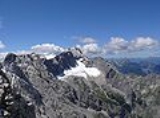
The Zugspitze, at 2,962 metres above sea level
, is the highest peak of the Wetterstein Mountains as well as the highest mountain
in Germany
. It lies south of the town of Garmisch-Partenkirchen
, and the border between Germany and Austria runs over its western summit. South of the mountain is the Zugspitzplatt, a high karst
plateau
with numerous caves. On the flanks of the Zugspitze are three glaciers, including the two largest in Germany: the Northern Schneeferner with an area of 30.7 hectare
s and the Höllentalferner
with an area of 24.7 hectares.
Normalhöhennull
Normalhöhennull or NHN is a standard reference level, the equivalent of sea level, used in Germany to measure height....
, is the highest peak of the Wetterstein Mountains as well as the highest mountain
Mountain
Image:Himalaya_annotated.jpg|thumb|right|The Himalayan mountain range with Mount Everestrect 58 14 160 49 Chomo Lonzorect 200 28 335 52 Makalurect 378 24 566 45 Mount Everestrect 188 581 920 656 Tibetan Plateaurect 250 406 340 427 Rong River...
in Germany
Germany
Germany , officially the Federal Republic of Germany , is a federal parliamentary republic in Europe. The country consists of 16 states while the capital and largest city is Berlin. Germany covers an area of 357,021 km2 and has a largely temperate seasonal climate...
. It lies south of the town of Garmisch-Partenkirchen
Garmisch-Partenkirchen
Garmisch-Partenkirchen is a mountain resort town in Bavaria, southern Germany. It is the administrative centre of the district of Garmisch-Partenkirchen, in the Oberbayern region, and the district is on the border with Austria...
, and the border between Germany and Austria runs over its western summit. South of the mountain is the Zugspitzplatt, a high karst
KARST
Kilometer-square Area Radio Synthesis Telescope is a Chinese telescope project to which FAST is a forerunner. KARST is a set of large spherical reflectors on karst landforms, which are bowlshaped limestone sinkholes named after the Kras region in Slovenia and Northern Italy. It will consist of...
plateau
Plateau
In geology and earth science, a plateau , also called a high plain or tableland, is an area of highland, usually consisting of relatively flat terrain. A highly eroded plateau is called a dissected plateau...
with numerous caves. On the flanks of the Zugspitze are three glaciers, including the two largest in Germany: the Northern Schneeferner with an area of 30.7 hectare
Hectare
The hectare is a metric unit of area defined as 10,000 square metres , and primarily used in the measurement of land. In 1795, when the metric system was introduced, the are was defined as being 100 square metres and the hectare was thus 100 ares or 1/100 km2...
s and the Höllentalferner
Höllentalferner
The Höllentalferner is a glacier in the western Wetterstein Mountains. It is a cirque glacier that covers the upper part of the Höllental valley and its location in a rocky bowl between the Riffelwandspitzen and Germany's highest mountain, the Zugspitze, means that it is well-protected from direct...
with an area of 24.7 hectares.
Unanswered Questions
Discussions