

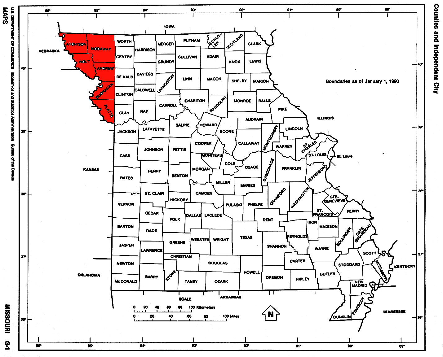
Platte Purchase
Encyclopedia
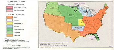
United States
The United States of America is a federal constitutional republic comprising fifty states and a federal district...
government from Native American
Native Americans in the United States
Native Americans in the United States are the indigenous peoples in North America within the boundaries of the present-day continental United States, parts of Alaska, and the island state of Hawaii. They are composed of numerous, distinct tribes, states, and ethnic groups, many of which survive as...
tribes all of which was east bank lands along the Missouri River
Missouri River
The Missouri River flows through the central United States, and is a tributary of the Mississippi River. It is the longest river in North America and drains the third largest area, though only the thirteenth largest by discharge. The Missouri's watershed encompasses most of the American Great...
that added 3149 square miles (8,156 km²) to the northwest corner of the state of Missouri
Missouri
Missouri is a US state located in the Midwestern United States, bordered by Iowa, Illinois, Kentucky, Tennessee, Arkansas, Oklahoma, Kansas and Nebraska. With a 2010 population of 5,988,927, Missouri is the 18th most populous state in the nation and the fifth most populous in the Midwest. It...
. The area acquired is almost as large as the states of Delaware
Delaware
Delaware is a U.S. state located on the Atlantic Coast in the Mid-Atlantic region of the United States. It is bordered to the south and west by Maryland, and to the north by Pennsylvania...
and Rhode Island
Rhode Island
The state of Rhode Island and Providence Plantations, more commonly referred to as Rhode Island , is a state in the New England region of the United States. It is the smallest U.S. state by area...
combined, and extended Missouri north and westward along the river. St. Joseph, one of the main ports of departure for the westward migration of American pioneer
American pioneer
American pioneers are any of the people in American history who migrated west to join in settling and developing new areas. The term especially refers to those who were going to settle any territory which had previously not been settled or developed by European or American society, although the...
s was located in the new acquisition.
The region includes the following modern counties within its bounds: Andrew
Andrew County, Missouri
-External links:* from University of Missouri Division of Special Collections, Archives, and Rare Books...
(435 square miles, 1127 km²), Atchison
Atchison County, Missouri
Atchison County is a county located in the U.S. state of Missouri. As of 2010, the population was 5,685. Its county seat is Rock Port. The county was organized in 1845 and named for David Rice Atchison, U.S...
(545 square miles, 1412 km²), Buchanan
Buchanan County, Missouri
Buchanan County is a county located in the U.S. state of Missouri. As of 2010, the population was 89,201. Its county seat is Saint Joseph. When originally formed in 1838, the county was named Roberts County, after settler Hiram Roberts; it was renamed in 1839 for James Buchanan, then a U.S....
(410 square miles, 1062 km²), Holt
Holt County, Missouri
Holt County is a county located in the U.S. state of Missouri. The county is in the northwest part of the state. As of 2010, the population was 4,912. Its county seat is Oregon. The county was organized in 1841 and is named after the Missouri state legislator Dr...
(462 square miles, 1197 km²), Nodaway
Nodaway County, Missouri
Nodaway County is a county located in the U.S. state of Missouri. The county was organized in 1845 and named for the Nodaway River.As of 2010, the population was 23,370...
(877 square miles, 2271 km²), and Platte
Platte County, Missouri
As of the census of 2000, there were 73,781 people, 29,278 households, and 20,231 families residing in the county. The population density was 176 people per square mile . There were 30,902 housing units at an average density of 74 per square mile...
(420 square miles, 1088 km²). It also includes the northwest suburbs of Kansas City
Kansas City, Missouri
Kansas City, Missouri is the largest city in the U.S. state of Missouri and is the anchor city of the Kansas City Metropolitan Area, the second largest metropolitan area in Missouri. It encompasses in parts of Jackson, Clay, Cass, and Platte counties...
, a small area of Kansas City proper, the cities of St. Joseph, Mound City
Mound City, Missouri
Mound City is a city in Holt County, Missouri, United States. The population was 1,193 at the 2000 census.-Geography:Mound City is located at , at the southern end of the Loess Hills. It is named for the hills in the area...
and Maryville, Missouri
Maryville, Missouri
Maryville is a city in Nodaway County, Missouri, United States. The population was 10,581 at the 2000 census. The town, organized on February 14, 1845, was named for Mrs. Mary Graham, wife of Amos Graham, then the county clerk. Mary was the first Caucasian woman to have lived within the boundaries...
, as well as Kansas City International Airport
Kansas City International Airport
Kansas City International Airport , originally named Mid-Continent International Airport, is a public airport located 15 miles northwest of the central business district of Kansas City, in Platte County, Missouri, United States. In 2008, 10,469,892 passengers used the airport...
and almost all of Missouri's portion of Interstate 29
Interstate 29
Interstate 29 is an Interstate Highway in the Midwestern United States. I-29 runs from Kansas City, Missouri, at a junction with Interstate 35 and Interstate 70 to the Canadian border near Pembina, North Dakota, where it connects with Manitoba Highway 75 via the short Manitoba Highway 29.-Route...
, save the small portion which runs concurrently with Interstate 35
Interstate 35
Interstate 35 is a north–south Interstate Highway in the central United States. I-35 stretches from Laredo, Texas, on the U.S.-Mexico border to Duluth, Minnesota, at Minnesota Highway 61 and 26th Avenue East. Many interstates used to have splits or spurs indicated with suffixed letters , but I-35...
in Clay County.
History
Native American people living in unorganized portions of the Missouri TerritoryMissouri Territory
The Territory of Missouri was an organized incorporated territory of the United States that existed from June 4, 1812 until August 10, 1821, when the southeastern portion of the territory was admitted to the Union as the State of Missouri.-History:...
had been promised that they would keep their land permanently. European Americans began to encroach on the territory, violating the agreement with the United States government. Joseph Robidoux
Joseph Robidoux
Joseph Robidoux III established the Blacksnake Hills Trading Post that eventually became St. Joseph, Missouri.-Biography:...
lobbied for incorporation of settled territory, located east of the Missouri River
Missouri River
The Missouri River flows through the central United States, and is a tributary of the Mississippi River. It is the longest river in North America and drains the third largest area, though only the thirteenth largest by discharge. The Missouri's watershed encompasses most of the American Great...
to the latitude of the state's northern border, into the recently formed state of Missouri.
An agreement was reached in 1836 with the chiefs Mahaska
Chief Mahaska
Mahaska , or White Cloud, was a chief of the Native American Iowa tribe.-Early life and education:Mahaska was born into the Iowa tribe...
and No Heart of the Ioway tribe and leaders of the combined Sac and Fox tribes in a ceremony at Fort Leavenworth, Kansas that was presided by William Clark, then Indian Superintendent of Indian Affairs and based in St. Louis. (He was one of the leaders of the Lewis and Clark Expedition
Lewis and Clark Expedition
The Lewis and Clark Expedition, or ″Corps of Discovery Expedition" was the first transcontinental expedition to the Pacific Coast by the United States. Commissioned by President Thomas Jefferson and led by two Virginia-born veterans of Indian wars in the Ohio Valley, Meriwether Lewis and William...
.)
The tribes were paid $7,500 for their land. The U.S. government was to "build five comfortable houses for each tribe, break up 200 acre (0.809372 km²) of land, fence 200 acre (0.809372 km²) of land, furnish a farmer, blacksmith, teacher, interpreter, provide agricultural implements, furnish livestock" and a host of other small items. The tribes agreed to move to reservations west of the Missouri River in what was to become Kansas
Kansas
Kansas is a US state located in the Midwestern United States. It is named after the Kansas River which flows through it, which in turn was named after the Kansa Native American tribe, which inhabited the area. The tribe's name is often said to mean "people of the wind" or "people of the south...
and Nebraska
Nebraska
Nebraska is a state on the Great Plains of the Midwestern United States. The state's capital is Lincoln and its largest city is Omaha, on the Missouri River....
, today known as the Ioway Reservation
Ioway Reservation
The Iowa Reservation of the Ioway Tribe of Kansas and Nebraska straddles the borders of southeast Richardson County in southeastern Nebraska and Brown and Doniphan Counties in northeastern Kansas. Tribal headquarters are west of White Cloud, Kansas. The reservation was defined in a treaty from...
and the Sac and Fox Reservation
Sac and Fox Reservation
The Sac and Fox Reservation of the Sac and Fox is a 23.639 sq mi tract located in southeastern Richardson County, Nebraska, and northeastern Brown County, Kansas. It was created as a consequence of the Platte Purchase of 1836....
.
The western border of Missouri was established at the mouth of the Kaw River in Kansas City (94 degrees 36 minutes West longitude)http://maps.google.com/maps?f=q&hl=en&om=1&ll=39.115411,-94.60722&spn=0.089635,0.156898 (which is also the border between Missouri and Kansas). The purchase extended the Missouri border in the northwest to 95 degrees 46 minutes West longitude).http://maps.google.com/maps?f=q&hl=en&om=1&ll=40.585474,-95.765676&spn=0.043868,0.10643
On 28 March 1837, President Martin Van Buren
Martin Van Buren
Martin Van Buren was the eighth President of the United States . Before his presidency, he was the eighth Vice President and the tenth Secretary of State, under Andrew Jackson ....
proclaimed the Platte Purchase part of the state of Missouri, making what was the largest state in the union at that time even larger.
Current maps show the eastern border of Platte County and all counties north further east than the border between Missouri and Kansas south of the river, which no longer conforms to the mouth of the Kaw River.
See also
- Historic regions of the United StatesHistoric regions of the United StatesThis is a list of historic regions of the United States.-Colonial era :-The Thirteen Colonies:* Connecticut Colony* Delaware Colony* Province of Georgia* Province of Maryland...
- Ioway ReservationIoway ReservationThe Iowa Reservation of the Ioway Tribe of Kansas and Nebraska straddles the borders of southeast Richardson County in southeastern Nebraska and Brown and Doniphan Counties in northeastern Kansas. Tribal headquarters are west of White Cloud, Kansas. The reservation was defined in a treaty from...
- Sac and Fox ReservationSac and Fox ReservationThe Sac and Fox Reservation of the Sac and Fox is a 23.639 sq mi tract located in southeastern Richardson County, Nebraska, and northeastern Brown County, Kansas. It was created as a consequence of the Platte Purchase of 1836....