
Geary County, Kansas
Encyclopedia
Geary County is a county located in Northeast Kansas
, in the Central
United States
. As of the 2010 census, the county population was 34,362. Its county seat
and most populous city is Junction City
. The county is named in honor of Governor
John W. Geary
. Geary County is part of the Manhattan
, Kansas
, Metropolitan Statistical Area.
Geary County was originally named Davis County, but the name was changed after Jefferson Davis became president of the Confederacy. The county is named in honor of John W. Geary
, an early Governor of the Kansas Territory
.
, county until the Kansas Constitution was amended in 1986 and voters approved the sale of alcoholic liquor by the individual drink with a 30% food sales requirement. The food sales requirement was removed with voter approval in 1990.
 As of the U.S. Census in 2000
, there were 27,947 people, 10,458 households, and 7,582 families residing in the county. The population density
was 73 people per square mile (28/km²). There were 11,959 housing units at an average density of 31 per square mile (12/km²). The racial makeup
of the county was 64.13% White
, 22.03% Black or African American
, 0.75% Native American
, 3.16% Asian
, 0.41% Pacific Islander
, 4.10% from other races, and 5.41% from two or more races
. Hispanic
or Latino
of any race were 8.45% of the population.
There were 10,458 household
s out of which 39.60% had children under the age of 18 living with them, 56.90% were married couples
living together, 12.30% had a female householder with no husband present, and 27.50% were non-families. 22.50% of all households were made up of individuals and 7.80% had someone living alone who was 65 years of age or older. The average household size was 2.61 and the average family size was 3.07.
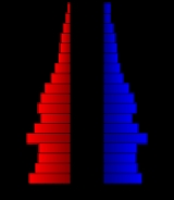
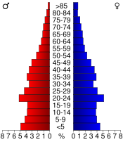
In the county the population was spread out with 29.60% under the age of 18, 13.60% from 18 to 24, 30.00% from 25 to 44, 17.40% from 45 to 64, and 9.40% who were 65 years of age or older. The median age was 29 years. For every 100 females there were 97.30 males. For every 100 females age 18 and over, there were 94.30 males.
The median income for a household
in the county was $31,917, and the median income for a family was $36,372. Males had a median income of $25,942 versus $21,389 for females. The per capita income
for the county was $16,199. About 9.70% of families and 12.10% of the population were below the poverty line, including 16.80% of those under age 18 and 9.90% of those age 65 or over.
and Republican
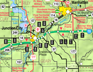
rivers, the Fort Riley
Military Reservation covers 100656 acres (407 km²) in Geary and Riley
counties. The fort has a daytime population of nearly 25,000 and includes two census-designated place
s:
. The city of Junction City
is considered governmentally independent and is excluded from the census figures for the townships. In the following table, the population center is the largest city (or cities) included in that township's population total, if it is of a significant size.
Historical
Maps
Kansas
Kansas is a US state located in the Midwestern United States. It is named after the Kansas River which flows through it, which in turn was named after the Kansa Native American tribe, which inhabited the area. The tribe's name is often said to mean "people of the wind" or "people of the south...
, in the Central
Central United States
The Central United States is sometimes conceived as between the Eastern United States and Western United States as part of a three-region model, roughly coincident with the Midwestern United States plus the western and central portions of the Southern United States; the term is also sometimes used...
United States
United States
The United States of America is a federal constitutional republic comprising fifty states and a federal district...
. As of the 2010 census, the county population was 34,362. Its county seat
County seat
A county seat is an administrative center, or seat of government, for a county or civil parish. The term is primarily used in the United States....
and most populous city is Junction City
Junction City, Kansas
Junction City is a city in and the county seat of Geary County, Kansas, United States. As of the 2010 census, the city population was 23,353. Fort Riley, a major U.S. Army post, is nearby...
. The county is named in honor of Governor
Governor of Kansas
The Governor of the State of Kansas is the head of state for the State of Kansas, United States. Under the Kansas Constitution, the Governor is also the head of government, serving as the chief executive of the Kansas executive branch, of the government of Kansas. The Governor is the...
John W. Geary
John W. Geary
John White Geary was an American lawyer, politician, Freemason, and a Union general in the American Civil War...
. Geary County is part of the Manhattan
Manhattan, Kansas
Manhattan is a city located in the northeastern part of the state of Kansas in the United States, at the junction of the Kansas River and Big Blue River. It is the county seat of Riley County and the city extends into Pottawatomie County. As of the 2010 census, the city population was 52,281...
, Kansas
Kansas
Kansas is a US state located in the Midwestern United States. It is named after the Kansas River which flows through it, which in turn was named after the Kansa Native American tribe, which inhabited the area. The tribe's name is often said to mean "people of the wind" or "people of the south...
, Metropolitan Statistical Area.
History
Geary County was formed on August 30, 1855 as an original county from open, free territory. It was among the first 33 counties established by the territory government.Geary County was originally named Davis County, but the name was changed after Jefferson Davis became president of the Confederacy. The county is named in honor of John W. Geary
John W. Geary
John White Geary was an American lawyer, politician, Freemason, and a Union general in the American Civil War...
, an early Governor of the Kansas Territory
Kansas Territory
The Territory of Kansas was an organized incorporated territory of the United States that existed from May 30, 1854, until January 29, 1861, when the eastern portion of the territory was admitted to the Union as the State of Kansas....
.
Law and government
Geary County was a prohibition, or "dry"Dry county
A dry county is a county in the United States whose government forbids the sale of alcoholic beverages. Some prohibit off-premises sale, some prohibit on-premises sale, and some prohibit both. Hundreds of dry counties exist across the United States, almost all of them in the South...
, county until the Kansas Constitution was amended in 1986 and voters approved the sale of alcoholic liquor by the individual drink with a 30% food sales requirement. The food sales requirement was removed with voter approval in 1990.
Geography
According to the 2000 census, the county has a total area of 404.39 square miles (1,047.4 km²), of which 384.69 square miles (996.3 km²) (or 95.13%) is land and 19.7 square miles (51 km²) (or 4.87%) is water.Adjacent counties
- Riley CountyRiley County, KansasRiley County is a county located in the U.S. state of Kansas. The county's population was 71,115 for the 2010 census. The largest city and county seat is Manhattan. The county is part of the Manhattan, Kansas, Metropolitan Statistical Area.Riley County is home to two of Kansas' largest...
(north) - Wabaunsee CountyWabaunsee County, KansasWabaunsee County is a county located in the U.S. state of Kansas. As of the 2010 census, the county population was 7,053. Its county seat is Alma. It is part of the Topeka, Kansas Metropolitan Statistical Area...
(east) - Morris CountyMorris County, KansasMorris County is a county located in the U.S. state of Kansas. As of the 2010 census, the county population was 5,923. The largest city and county seat is Council Grove.-19th century:...
(south) - Dickinson CountyDickinson County, KansasDickinson County is a county located in Central Kansas, in the Central United States. As of the 2010 census, the county population was 19,754. Its county seat and most populous city is Abilene. It was named in honor of Daniel S. Dickinson.-19th century:In 1887, Mr. Herington successfully got...
(west) - Clay CountyClay County, KansasClay County is a county located in North Central Kansas, in the Central United States. As of the 2010 census, the county population was 8,535...
(northwest)
Demographics
United States Census, 2000
The Twenty-second United States Census, known as Census 2000 and conducted by the Census Bureau, determined the resident population of the United States on April 1, 2000, to be 281,421,906, an increase of 13.2% over the 248,709,873 persons enumerated during the 1990 Census...
, there were 27,947 people, 10,458 households, and 7,582 families residing in the county. The population density
Population density
Population density is a measurement of population per unit area or unit volume. It is frequently applied to living organisms, and particularly to humans...
was 73 people per square mile (28/km²). There were 11,959 housing units at an average density of 31 per square mile (12/km²). The racial makeup
Race (United States Census)
Race and ethnicity in the United States Census, as defined by the Federal Office of Management and Budget and the United States Census Bureau, are self-identification data items in which residents choose the race or races with which they most closely identify, and indicate whether or not they are...
of the county was 64.13% White
White American
White Americans are people of the United States who are considered or consider themselves White. The United States Census Bureau defines White people as those "having origins in any of the original peoples of Europe, the Middle East, or North Africa...
, 22.03% Black or African American
African American
African Americans are citizens or residents of the United States who have at least partial ancestry from any of the native populations of Sub-Saharan Africa and are the direct descendants of enslaved Africans within the boundaries of the present United States...
, 0.75% Native American
Native Americans in the United States
Native Americans in the United States are the indigenous peoples in North America within the boundaries of the present-day continental United States, parts of Alaska, and the island state of Hawaii. They are composed of numerous, distinct tribes, states, and ethnic groups, many of which survive as...
, 3.16% Asian
Asian American
Asian Americans are Americans of Asian descent. The U.S. Census Bureau definition of Asians as "Asian” refers to a person having origins in any of the original peoples of the Far East, Southeast Asia, or the Indian subcontinent, including, for example, Cambodia, China, India, Indonesia, Japan,...
, 0.41% Pacific Islander
Pacific Islander American
Pacific Islander Americans, also known as Oceanian Americans, are residents of the United States with original ancestry from Oceania. They represent the smallest racial group counted in the United States census of 2000. They numbered 874,000 people or 0.3 percent of the United States population...
, 4.10% from other races, and 5.41% from two or more races
Multiracial
The terms multiracial and mixed-race describe people whose ancestries come from multiple races. Unlike the term biracial, which often is only used to refer to having parents or grandparents of two different races, the term multiracial may encompass biracial people but can also include people with...
. Hispanic
Hispanic
Hispanic is a term that originally denoted a relationship to Hispania, which is to say the Iberian Peninsula: Andorra, Gibraltar, Portugal and Spain. During the Modern Era, Hispanic sometimes takes on a more limited meaning, particularly in the United States, where the term means a person of ...
or Latino
Latino
The demonyms Latino and Latina , are defined in English language dictionaries as:* "a person of Latin-American descent."* "A Latin American."* "A person of Hispanic, especially Latin-American, descent, often one living in the United States."...
of any race were 8.45% of the population.
There were 10,458 household
Household
The household is "the basic residential unit in which economic production, consumption, inheritance, child rearing, and shelter are organized and carried out"; [the household] "may or may not be synonymous with family"....
s out of which 39.60% had children under the age of 18 living with them, 56.90% were married couples
Marriage
Marriage is a social union or legal contract between people that creates kinship. It is an institution in which interpersonal relationships, usually intimate and sexual, are acknowledged in a variety of ways, depending on the culture or subculture in which it is found...
living together, 12.30% had a female householder with no husband present, and 27.50% were non-families. 22.50% of all households were made up of individuals and 7.80% had someone living alone who was 65 years of age or older. The average household size was 2.61 and the average family size was 3.07.
In the county the population was spread out with 29.60% under the age of 18, 13.60% from 18 to 24, 30.00% from 25 to 44, 17.40% from 45 to 64, and 9.40% who were 65 years of age or older. The median age was 29 years. For every 100 females there were 97.30 males. For every 100 females age 18 and over, there were 94.30 males.
The median income for a household
Median household income
The median household income is commonly used to generate data about geographic areas and divides households into two equal segments with the first half of households earning less than the median household income and the other half earning more...
in the county was $31,917, and the median income for a family was $36,372. Males had a median income of $25,942 versus $21,389 for females. The per capita income
Per capita income
Per capita income or income per person is a measure of mean income within an economic aggregate, such as a country or city. It is calculated by taking a measure of all sources of income in the aggregate and dividing it by the total population...
for the county was $16,199. About 9.70% of families and 12.10% of the population were below the poverty line, including 16.80% of those under age 18 and 9.90% of those age 65 or over.
Incorporated cities
Name and population (2004 estimate):- Junction CityJunction City, KansasJunction City is a city in and the county seat of Geary County, Kansas, United States. As of the 2010 census, the city population was 23,353. Fort Riley, a major U.S. Army post, is nearby...
, 18,886 (county seat) - Grandview PlazaGrandview Plaza, KansasGrandview Plaza is a city in Geary County, Kansas, United States. As of the 2010 census, the city population was 1,560. It is part of the Manhattan, Kansas Metropolitan Statistical Area.-Geography:Grandview Plaza is located at...
, 1,071 - MilfordMilford, KansasMilford is a city in Geary County, Kansas, in the United States. As of the 2010 census, the city population was 530. It is part of the Manhattan, Kansas Metropolitan Statistical Area.-Geography:Milford is located at...
, 453
Fort Riley
Located north of the junction of the Smoky HillSmoky Hill River
The Smoky Hill River is a river in the central Great Plains of North America, running through the U.S. states of Colorado and Kansas.-Names:The Smoky Hill gets its name from the Smoky Hills region of north-central Kansas through which it flows...
and Republican
Republican River
The Republican River is a river in the central Great Plains of North America, flowing through the U.S. states of Nebraska and Kansas.-Geography:...
rivers, the Fort Riley
Fort Riley
Fort Riley is a United States Army installation located in Northeast Kansas, on the Kansas River, between Junction City and Manhattan. The Fort Riley Military Reservation covers 100,656 acres in Geary and Riley counties and includes two census-designated places: Fort Riley North and Fort...
Military Reservation covers 100656 acres (407 km²) in Geary and Riley
Riley County, Kansas
Riley County is a county located in the U.S. state of Kansas. The county's population was 71,115 for the 2010 census. The largest city and county seat is Manhattan. The county is part of the Manhattan, Kansas, Metropolitan Statistical Area.Riley County is home to two of Kansas' largest...
counties. The fort has a daytime population of nearly 25,000 and includes two census-designated place
Census-designated place
A census-designated place is a concentration of population identified by the United States Census Bureau for statistical purposes. CDPs are delineated for each decennial census as the statistical counterparts of incorporated places such as cities, towns and villages...
s:
- Fort Riley NorthFort Riley North, KansasFort Riley North is a census-designated place that covers part of Fort Riley, a US Army installation in Geary and Riley counties in the U.S. state of Kansas. The area is more commonly known as "Custer Hill"...
- Fort Riley-Camp WhitesideFort Riley-Camp Whiteside, KansasFort Riley-Camp Whiteside is a census-designated place that covers part of Fort Riley, a US Army installation in Geary County, Kansas, United States...
Townships
Geary County is divided into eight townshipsCivil township
A civil township is a widely used unit of local government in the United States, subordinate to, and geographic divisions of, a county. Specific responsibilities and the degree of autonomy vary based on each state. Civil townships are distinct from survey townships, but in states that have both,...
. The city of Junction City
Junction City, Kansas
Junction City is a city in and the county seat of Geary County, Kansas, United States. As of the 2010 census, the city population was 23,353. Fort Riley, a major U.S. Army post, is nearby...
is considered governmentally independent and is excluded from the census figures for the townships. In the following table, the population center is the largest city (or cities) included in that township's population total, if it is of a significant size.
| Township | FIPS | Population center |
Population | Population density /km² (/sq mi) |
Land area km² (sq mi) | Water area km² (sq mi) | Water % | Geographic coordinates |
|---|---|---|---|---|---|---|---|---|
| Blakely | 07275 | 113 | 1 (3) | 93 (36) | 0 (0) | 0.01% | 38°54′32"N 96°45′9"W | |
| Jackson | 34775 | 78 | 1 (2) | 104 (40) | 0 (0) | 0 % | 39°1′25"N 96°33′42"W | |
| Jefferson | 35200 | Grandview Plaza Grandview Plaza, Kansas Grandview Plaza is a city in Geary County, Kansas, United States. As of the 2010 census, the city population was 1,560. It is part of the Manhattan, Kansas Metropolitan Statistical Area.-Geography:Grandview Plaza is located at... |
1,651 | 13 (35) | 124 (48) | 2 (1) | 1.55% | 39°1′53"N 96°46′53"W |
| Liberty | 40050 | 225 | 1 (3) | 171 (66) | 0 (0) | 0.03% | 38°54′53"N 96°36′8"W | |
| Lyon | 43500 | 298 | 3 (7) | 113 (43) | 1 (1) | 1.20% | 38°55′17"N 96°52′3"W | |
| Milford | 46550 | 1,583 | 16 (41) | 101 (39) | 28 (11) | 21.49% | 39°8′59"N 96°54′22"W | |
| Smoky Hill | 66000 | 4,974 | 33 (86) | 149 (58) | 20 (8) | 11.84% | 39°2′14"N 96°53′58"W | |
| Wingfield | 80025 | 139 | 1 (3) | 123 (48) | 0 (0) | 0 % | 38°59′38"N 96°38′37"W | |
| Sources: | ||||||||
See also
- National Register of Historic Places listings in Geary County, KansasNational Register of Historic Places listings in Geary County, KansasThis is a list of the National Register of Historic Places listings in Geary County, Kansas.This is intended to be a complete list of the properties and districts on the National Register of Historic Places in Geary County, Kansas, United States...
Further reading
- History of the State of Kansas; William G. Cutler; A.T. Andreas Publisher; 1883. (Online HTML eBook)
- Kansas : A Cyclopedia of State History, Embracing Events, Institutions, Industries, Counties, Cities, Towns, Prominent Persons, Etc; 3 Volumes; Frank W. Blackmar; Standard Publishing Co; 944 / 955 / 824 pages; 1912. (Volume1 - Download 54MB PDF eBook),(Volume2 - Download 53MB PDF eBook), (Volume3 - Download 33MB PDF eBook)
External links
Official sites- Geary County
- Junction City and Geary County Economic Development
- Geary County Convention & Visitors Bureau
- Geary County - Information, Skyways
- Fort Riley
Historical
Maps
- Geary County Map, KDOT
- Kansas Highway Map, KDOT
- Kansas Railroad Map, KDOT
- Kansas School District Boundary Map, KSDE