
Fanno Creek
Encyclopedia
Fanno Creek is a 15 miles (24.1 km) tributary of the Tualatin River
in the U.S. state of Oregon
. Part of the drainage basin of the Columbia River
, its watershed covers about 32 square miles (82.9 km²) in Multnomah
, Washington
, and Clackamas
counties, including about 7 square miles (18.1 km²) within the Portland
city limits.
From its headwaters in the Tualatin Mountains
(West Hills) in southwest Portland, the creek flows generally west and south through the cities of Portland, Beaverton
, Tigard
and Durham
, and unincorporated area
s of Washington County. It enters the Tualatin River about 9 miles (14 km) above the Tualatin's confluence with the Willamette River
at West Linn
.
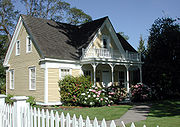
For thousands of years, the Atfalati (Tualatin) tribe of the Kalapuya inhabited the watershed. The first settler of European descent, Augustus Fanno, for whom the creek is named, arrived in the mid-19th century. He established an onion farm in what became Beaverton. Fanno Farmhouse
, the restored family home, is a Century Farm
on the National Register of Historic Places
and is one of 14 urban parks in a narrow corridor along the creek.
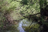
Although heavily polluted, the creek supports aquatic life, including cutthroat trout
in its upper reaches. Watershed councils such as the Friends of Fanno Creek and government agencies have worked to limit pollution and to restore native vegetation in riparian zones.
and falls 370 feet (112.8 m) between source and mouth to an elevation of 108 feet (32.9 m). The main stem begins at about river mile
(RM) 15 or river kilometer (RK) 24 in the Hillsdale
neighborhood of southwest Portland, in Multnomah County. The creek flows west along the north side of Oregon Route 10 (the Beaverton–Hillsdale Highway), passing Albert Kelly Park and receiving Ivey Creek and Bridlemile Creek on the right before reaching the United States Geological Survey
(USGS) stream gauge at Southwest 56th Avenue 11.9 miles (19.2 km) from the mouth. Shortly thereafter and in quick succession, it enters Washington County
and the unincorporated community of Raleigh Hills
, crosses under Route 10, and receives Sylvan Creek on the right. Here the stream turns south, passing through Bauman Park, where Vermont Creek enters on the left about 10 miles (16.1 km) from the mouth, and then southwest to flow through the Portland Golf Club and Vista Brook Park, where Woods Creek enters on the left. From here it flows west again for about 1 miles (1.6 km), passing through Fanno Creek Trail Park and entering Beaverton about 8 miles (12.9 km) from the mouth before turning sharply south and flowing under Oregon Route 217 (Beaverton–Tigard Highway).
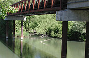
Fanno Creek then flows roughly parallel to Route 217 for about 2 miles (3 km) through Fanno Creek Park and Greenway Park. Near the southern end of Greenway Park, the creek passes under Oregon Route 210 (Scholls Ferry Road), and enters Tigard about 5 miles (8 km) from the mouth. In quick succession, Hiteon Creek enters on the right, Ash Creek on the left, and Summer Creek on the right before the creek reaches Woodard Park, goes under Oregon Route 99W (Southwest Pacific Highway), and flows through Fanno Park and Bonita Park as well as residential neighborhoods. Between the two parks, Red Rock Creek enters on the left about 2.5 miles (4 km) from the mouth. Slightly downstream of Bonita Park, Ball Creek enters on the left. Fanno Creek then enters Durham, passes a USGS gauging station 1.13 miles (1.8 km) from the mouth, flows through Durham City Park, and empties into the Tualatin River 9.3 miles (15 km) from its confluence with the Willamette
 Draining 31.7 square miles (82.1 km²), Fanno Creek receives water from Portland's West Hills
, Sexton Mountain in Beaverton, and Bull Mountain
near Tigard. Nearly all of the watershed is urban. About 7 square miles (18.1 km²), roughly 22 percent of the total, lies inside the Portland city limits. The highest elevation in the watershed is 1060 feet (323.1 m) at Council Crest
in the West Hills. The peak elevation on Sexton Mountain is 476 feet (145.1 m), while Bull Mountain rises to 715 feet (217.9 m). About 117 miles (188.3 km) of streams flow through the watershed, including Ash Creek, Summer Creek, and 12 smaller tributaries. A small part of the drainage basin lies in the city of Lake Oswego
in Clackamas County
, near the headwaters of Ball Creek, a Fanno Creek tributary.
The slopes at the headwaters of Fanno Creek consist mainly of Columbia River Basalt
exposed in ravines but otherwise covered by up to 25 feet (8 m) of wind-deposited silt. Silts and clays are the most common watershed soils, and significant erosion
is common. About 50 inches (1,270 mm) of precipitation, almost all of which is rain and about half of which arrives in November, December, and January, falls on the watershed each year. Although significant flooding occurred in 1977, the watershed has not experienced a 100-year flood
since the area became urban.
Small watersheds adjacent to the Fanno Creek watershed include those of minor tributaries of the Willamette or Tualatin rivers. Tryon Creek
, Balch Creek
, and other small streams east of Fanno Creek flow down the eastern flank of the West Hills into the Willamette. To the northwest, Hall Creek, Cedar Mill Creek, and Bronson Creek flow into Beaverton Creek, a tributary of Rock Creek, which empties into the Tualatin River at the larger stream's RM 38.4 (RK 61.8), about 29 miles (46.7 km) upriver from the mouth of Fanno Creek.
 The first people of the Fanno Creek watershed were the Atfalati or Tualaty tribe of the Kalapuya, or "long grass" people, who inhabited large parts of the Willamette Valley for up to 10,000 years before the arrival of non-indigenous people
. The valleys of the Willamette River and its major tributaries such as the Tualatin River consisted of open grassland maintained by annual burning, with scattered groves of trees along the rivers and creeks. The Kalapuya moved from place to place in good weather to fish, to hunt small animals, birds, waterfowl, deer, and elk, and to gather nuts, seeds, roots, and berries. Important foods included camas
and wapato
. In addition to fishing for eels, suckers, and trout, the Atfalati traded for salmon from Chinookan
tribes near Willamette Falls
. During the winter, the Kalapuya lived in longhouses in settled villages. Their population was greatly reduced after contact in the late 18th century with Europeans, who carried smallpox
, syphilis
, and malaria
. Added pressure came from white settlers who seized and fenced native land, regarded it as private property, and sometimes punished natives for trespassing. Of the original population of 1,000 to 2,000 Atfalati reported in 1780, only 65 remained in 1851. In 1855, the U.S. government sent the survivors to the Grande Ronde reservation further west.
Fanno Creek is named after Augustus Fanno, the first European American settler along the creek. In 1847, he started an onion farm on a 640 acres (259 ha) donation land claim
in what later became part of Beaverton. Other 19th century newcomers along the creek engaged mainly in logging, farming, and dairy farming until the Southern Pacific Railroad
and the Oregon Electric Railway
lines made the watershed more accessible for urban development around the turn of the 20th century. The Oregon Electric, a 49 miles (78.9 km) system built between 1903 and 1915, ran between downtown Portland and Garden Home
in the Fanno Creek watershed, where it split into branches leading to Salem
and Forest Grove
. The Southern Pacific began running electric passenger trains, known as the Red Electric
, in the watershed in 1914. The company that eventually became Portland General Electric
installed electric service in the area, and by 1915 the population of the upper Fanno Creek neighborhoods of Multnomah, Maplewood
, Hillsdale, and West Portland Park
had grown to 2,000.
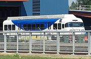 Passenger service on the Red Electric line ended in 1929, and the Oregon Electric Railway ceased passenger operations in 1933. Private autos largely replaced interurban rail service. Oregon Highway 217 between Durham and Beaverton, and Oregon Highway 10 between Beaverton and Portland, follow the creek. Although passenger rail ceased for nearly 80 years, freight trains continued to use the tracks. In 2009, a new rail passenger service began along a former Oregon Electric line owned by Portland and Western Railroad
in Washington County. The Westside Express Service (WES) runs 14.7 miles (23.7 km) between Beaverton on the north and Wilsonville
on the south. The middle stretch of this run lies close to the lower 8 miles (12.9 km) of Fanno Creek between Beaverton and Durham. WES is the first modern commuter rail in Oregon and one of the few suburb-to-suburb commuter rail lines in the United States. At the northern end of the line, WES connects to the MAX Blue Line
, an east-west light rail
line linking Hillsboro
and Gresham
via Portland and the MAX Red Line
, with connections to Portland International Airport
.
The highways and railroads serve a population that increased most dramatically in the second half of the 20th century. When Beaverton became a city in 1893, it had a population of 400. By 2010, the number had soared to 87,000, although not all of them lived in the watershed. Tigard, which did not exist as a city until 1961, grew to 41,000 by the year 2000, all in the watershed. The estimated population of the entire watershed reached 123,000 just before the 2000 census. Fanno Creek, which had few people living near it until 1850, "is surrounded by the most populous region in Oregon".
(DEQ) rated the average water quality of Fanno Creek as "very poor" between 1986 and 1995, it also noted steady improvement over that span. Historically, Fanno Creek has been polluted by urban and industrial sources, small sewage treatment plants, ineffective septic systems, farming and grazing operations, and illegal dumping. Health and environmental concerns led to the closing of substandard wastewater treatment plants in the 1970s, and urban development reduced the number of farms and farm animals along the creek. A ban in 1991 on phosphate
detergents, increased connection to municipal sewers, stormwater management, and greater public awareness helped to reduce urban pollution not coming from point sources, and water quality improved.
DEQ monitors Fanno Creek at Bonita Road in Tigard, at about 2 miles (3.2 km) from the mouth. On the Oregon Water Quality Index (OWQI) used by DEQ, water quality scores can vary from 10 (worst) to 100 (ideal). The average for Fanno Creek between 1986 and 1995 was 55 but steadily improved to 65, or "poor", by the end of the period. By comparison, the average in the nearby Willamette River at the Hawthorne Bridge in downtown Portland was 74 during the same years. Measurements of water quality at the Tigard site during the years covered by the DEQ report showed high concentrations of phosphates, fecal coliform bacteria
, and suspended solids, and a high biochemical oxygen demand
. Moderately high concentrations of ammonia
and nitrate
nitrogen occurred during high flows during fall, winter, and spring. High temperatures and low dissolved oxygen concentration in the summer were evidence of eutrophication
.
The high fraction of impervious surface
s in the watershed makes it difficult to improve water quality in the creek. The Portland Bureau of Environmental Services estimates that one-third of the surface area of the watershed that lies within its jurisdiction is impervious. All of the roughly 12 square miles (31.1 km²) of the surface of Tigard, much of it impervious, drains into Fanno Creek. The watershed watch coordinator for Tualatin Riverkeepers, a volunteer group, was quoted in a July 2008 newspaper article saying that "the biggest impact to Fanno Creek is the impervious area”. To slow run-off, reduce erosion, and keep pollutants out of streams, watershed councils, neighborhood groups, and government agencies have been planting native species of vegetation at selected sites throughout the watershed.
, raccoon
, opossum, spotted skunk
, Douglas squirrel
, and Townsend's chipmunk
; black-tail deer and coyote
s are more rare. Fanno Creek supports non-migrating cutthroat trout
that spawn
in the fast-flowing, gravel-bottomed headwaters and grow to a maximum length of about 7 inches (17.8 cm). Other fish species found in the creek include sculpin
s, dace
, and mosquitofish
.
As of March 2009, the extreme upper reaches of Fanno Creek were colonized by beaver. Two ponds created by beaver dams were visible from Beaverton-Hillsdale Highway, west of the intersection with Southwest Dosch Road. The City of Portland is taking remedial action to minimize damage to trees and brush by wrapping wire mesh around the bases of trees. Willow tree cuttings will be left for the beaver to use.
 The creek begins in the Coast Range ecoregion
designated by the U.S. Environmental Protection Agency
(EPA) and flows thereafter through the Willamette Valley ecoregion
. The narrow riparian corridors along streams in the watershed commonly include native species such as western redcedar
, Douglas-fir
, vine maple, and sword fern
as well as invasive species like English ivy
. Many red alder
and big leaf maple grow in the watershed, and shrubs include red huckleberry
, Oregon-grape
, elderberry, wood rose
, and salmonberry. A restoration project in Tigard along the main stem has removed invasive plants such as reed canary grass
and Himalayan blackberry
and replaced them with native species. A project in Beaverton is replacing turf and degraded habitat along the creek with native shrubs and trees such as Oregon white oak
.
The Tualatin Riverkeepers, a nonprofit watershed council based in Tigard; Clean Water Services, a public utility that protects water resources in the Tualatin River watershed, and the Tualatin Hills Park and Recreation District (THPRD) have formed the Tualatin Basin Invasive Species Working Group to identify and eradicate invasive plants that displace native plants, cause erosion, and diminish water quality. The five plants considered most threatening are Japanese knotweed
, meadow knapweed
, giant hogweed
, garlic mustard
and purple loosestrife. The Oregon Department of Agriculture and the city of Tigard are working to eradicate giant hogweed from lower Fanno Creek.
 Fanno Creek passes through or near 14 parks in several jurisdictions. Portland Parks & Recreation
manages three: Hillsdale Park, 5 acres (2 ha) with picnic tables and a dog park
near the headwaters; Albert Kelly Park, 12 acres (4.9 ha) with unpaved paths, picnic tables, play areas, and Wi-Fi
north of the creek about 14 miles (22.5 km) from the mouth, and the Fanno Creek Natural Area, 7 acres (2.8 ha) north of the creek about 12 miles (19.3 km) from the mouth.
The Tualatin Hills Park & Recreation District (THPRD) manages seven Fanno Creek parks in Beaverton and unincorporated Washington County. The district, tax-supported and governed by an elected board, is the largest special park and recreation district in Oregon. The seven include Bauman Park, about 8 acres (3.2 ha) at about 10 miles (16.1 km) from the mouth. Slightly downstream from Bauman Park are Vista Brook Park, about 4 acres (1.6 ha) with trails including one that is accessible
to people with physical handicaps, a playground, and courts for basketball and tennis, and Fanno Creek Trail, about 2 acre (0.809372 ha), with picnic tables and trails. Other THPRD parks lie along Fanno Creek from roughly 7 miles (11.3 km) to roughly 5 miles (8 km) from the mouth. These are Fanno Creek Park, about 21 acres (8.5 ha), with trails including one accessible to people with handicaps; Fanno Farmhouse, about 1 acre (0.404686 ha) with an accessible trail and picnic tables as well as the Fanno family home, restored by THPRD and listed on the National Register of Historic Places
; Greenway Park, about 87 acres (35.2 ha) with trails including an accessible trail, picnic tables, a playground, and sports fields, and Koll Center Wetlands, about 13 acres (5.3 ha) with wildlife.
The three Fanno Creek parks managed by the city of Tigard include Woodard Park, 10 acres (4 ha) of big trees, trails, and play structures; Bonita Park, with a playground and picnic areas, and Fanno Creek Park, a natural area behind City Hall. About 20 percent of the small city of Durham is parkland. Surrounded by the larger cities of Tigard and Tualatin
, the city covers 265 acres (107.2 ha) occupied by about 1,400 people. Durham City Park, at the confluence of Fanno Creek and the Tualatin River, consists of 46 acres (18.6 ha) of heavily wooded floodplain
with paved trails, children's play areas, and a picnic shelter.
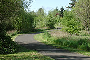
Sections of trail along the main stem of Fanno Creek form part of a planned 15 miles (24.1 km) Fanno Creek Greenway Trail linking Willamette Park
on the Willamette River in southwest Portland to the confluence of the creek with the Tualatin River in Durham. The trail, for pedestrians and bicyclists, is accessible to people with disabilities. Many unfinished segments remained as of 2008.
Tualatin River
The Tualatin River is a tributary of the Willamette River located in Oregon in the United States. The river is approximately long, and it drains a fertile farming region called the Tualatin Valley southwest and west of Portland at the northwest corner of the Willamette Valley...
in the U.S. state of Oregon
Oregon
Oregon is a state in the Pacific Northwest region of the United States. It is located on the Pacific coast, with Washington to the north, California to the south, Nevada on the southeast and Idaho to the east. The Columbia and Snake rivers delineate much of Oregon's northern and eastern...
. Part of the drainage basin of the Columbia River
Columbia River
The Columbia River is the largest river in the Pacific Northwest region of North America. The river rises in the Rocky Mountains of British Columbia, Canada, flows northwest and then south into the U.S. state of Washington, then turns west to form most of the border between Washington and the state...
, its watershed covers about 32 square miles (82.9 km²) in Multnomah
Multnomah County, Oregon
Multnomah County is one of 36 counties in the U.S. state of Oregon. Though smallest in area, it is the most populous as its county seat, Portland, is the state's largest city...
, Washington
Washington County, Oregon
- Major highways :* Interstate 5* Interstate 205* U.S. Route 26* Oregon Route 6* Oregon Route 8* Oregon Route 10* Oregon Route 47* Oregon Route 99W* Oregon Route 210* Oregon Route 217* Oregon Route 219-Demographics:...
, and Clackamas
Clackamas County, Oregon
Clackamas County is a county located in the U.S. state of Oregon. The county was named after the Native Americans living in the area, the Clackamas Indians, who were part of the Chinookan people. As of 2010, the population was 375,992...
counties, including about 7 square miles (18.1 km²) within the Portland
Portland, Oregon
Portland is a city located in the Pacific Northwest, near the confluence of the Willamette and Columbia rivers in the U.S. state of Oregon. As of the 2010 Census, it had a population of 583,776, making it the 29th most populous city in the United States...
city limits.
From its headwaters in the Tualatin Mountains
Tualatin Mountains
The Tualatin Mountains are a range of hills on the western border of Multnomah County, Oregon, United States...
(West Hills) in southwest Portland, the creek flows generally west and south through the cities of Portland, Beaverton
Beaverton, Oregon
Beaverton is a city in Washington County, Oregon, United States, seven miles west of Portland in the Tualatin River Valley.As of the 2010 census, the population is 90,267. This makes it the second-largest city in the county and Oregon's sixth-largest city...
, Tigard
Tigard, Oregon
Tigard is a city in Washington County, Oregon, United States. The population was 48,035 at the 2010 census. As of 2007, Tigard was the state's 12th largest city. Incorporated in 1961, the city is located south of Beaverton and north of Tualatin, and is part of the Portland metropolitan area...
and Durham
Durham, Oregon
Durham is a city in Washington County, Oregon, United States. Incorporated in 1966, the city is surrounded by Tigard and Tualatin and is adjacent to the Bridgeport Village shopping complex. The population was 1,382 at the 2000 census. The 2007 estimate is 1,395 residents.-History:The city was named...
, and unincorporated area
Unincorporated area
In law, an unincorporated area is a region of land that is not a part of any municipality.To "incorporate" in this context means to form a municipal corporation, a city, town, or village with its own government. An unincorporated community is usually not subject to or taxed by a municipal government...
s of Washington County. It enters the Tualatin River about 9 miles (14 km) above the Tualatin's confluence with the Willamette River
Willamette River
The Willamette River is a major tributary of the Columbia River, accounting for 12 to 15 percent of the Columbia's flow. The Willamette's main stem is long, lying entirely in northwestern Oregon in the United States...
at West Linn
West Linn, Oregon
West Linn is a city in Clackamas County, Oregon, United States. Now a prosperous southern suburb of Portland, West Linn has a history of early development, prompted by the opportunity to harvest energy from nearby Willamette Falls. It was named after Senator Dr. Lewis Fields Linn of Ste...
.
For thousands of years, the Atfalati (Tualatin) tribe of the Kalapuya inhabited the watershed. The first settler of European descent, Augustus Fanno, for whom the creek is named, arrived in the mid-19th century. He established an onion farm in what became Beaverton. Fanno Farmhouse
Augustus Fanno Farmhouse
The Augustus Fanno Farmhouse was the home of Augustus Fanno, one of the first European American settlers in what became Washington County in the U.S. state of Oregon. Born in Maine in 1804, Fanno lived in Missouri as a young adult and in 1846 moved to Oregon with his first wife, Martha, and son...
, the restored family home, is a Century Farm
Century Farm
A Century Farm or Centennial Farm is a farm or ranch in the United States or Canada that has been officially recognized by a regional program documenting the farm has been continuously owned by a single family for 100 years or more...
on the National Register of Historic Places
National Register of Historic Places
The National Register of Historic Places is the United States government's official list of districts, sites, buildings, structures, and objects deemed worthy of preservation...
and is one of 14 urban parks in a narrow corridor along the creek.
Although heavily polluted, the creek supports aquatic life, including cutthroat trout
Cutthroat trout
The cutthroat trout is a species of freshwater fish in the salmon family of order Salmoniformes. It is one of the many fish species colloquially known as trout...
in its upper reaches. Watershed councils such as the Friends of Fanno Creek and government agencies have worked to limit pollution and to restore native vegetation in riparian zones.
Course
Fanno Creek arises at an elevation of 478 feet (145.7 m) above sea levelSea level
Mean sea level is a measure of the average height of the ocean's surface ; used as a standard in reckoning land elevation...
and falls 370 feet (112.8 m) between source and mouth to an elevation of 108 feet (32.9 m). The main stem begins at about river mile
River mile
In the United States, a River mile is a measure of distance in miles along a river from its mouth. River mile numbers begin at zero and increase further upstream. The corresponding metric unit using kilometers is the River kilometer...
(RM) 15 or river kilometer (RK) 24 in the Hillsdale
Hillsdale, Portland, Oregon
The Hillsdale district is a neighborhood in the southwest section of Portland, Oregon, United States. It is centered around the Hillsdale retail and business area, a series of strip malls on SW Capitol Highway between SW Sunset Boulevard and SW Bertha Boulevard...
neighborhood of southwest Portland, in Multnomah County. The creek flows west along the north side of Oregon Route 10 (the Beaverton–Hillsdale Highway), passing Albert Kelly Park and receiving Ivey Creek and Bridlemile Creek on the right before reaching the United States Geological Survey
United States Geological Survey
The United States Geological Survey is a scientific agency of the United States government. The scientists of the USGS study the landscape of the United States, its natural resources, and the natural hazards that threaten it. The organization has four major science disciplines, concerning biology,...
(USGS) stream gauge at Southwest 56th Avenue 11.9 miles (19.2 km) from the mouth. Shortly thereafter and in quick succession, it enters Washington County
Washington County, Oregon
- Major highways :* Interstate 5* Interstate 205* U.S. Route 26* Oregon Route 6* Oregon Route 8* Oregon Route 10* Oregon Route 47* Oregon Route 99W* Oregon Route 210* Oregon Route 217* Oregon Route 219-Demographics:...
and the unincorporated community of Raleigh Hills
Raleigh Hills, Oregon
Raleigh Hills is a census-designated place and neighborhood within the metropolitan area of Portland, Oregon, in the United States. It is located in the southwest hills in Washington County, with Beaverton to the west, West Slope to the north, and Progress and Garden Home to the south...
, crosses under Route 10, and receives Sylvan Creek on the right. Here the stream turns south, passing through Bauman Park, where Vermont Creek enters on the left about 10 miles (16.1 km) from the mouth, and then southwest to flow through the Portland Golf Club and Vista Brook Park, where Woods Creek enters on the left. From here it flows west again for about 1 miles (1.6 km), passing through Fanno Creek Trail Park and entering Beaverton about 8 miles (12.9 km) from the mouth before turning sharply south and flowing under Oregon Route 217 (Beaverton–Tigard Highway).
Fanno Creek then flows roughly parallel to Route 217 for about 2 miles (3 km) through Fanno Creek Park and Greenway Park. Near the southern end of Greenway Park, the creek passes under Oregon Route 210 (Scholls Ferry Road), and enters Tigard about 5 miles (8 km) from the mouth. In quick succession, Hiteon Creek enters on the right, Ash Creek on the left, and Summer Creek on the right before the creek reaches Woodard Park, goes under Oregon Route 99W (Southwest Pacific Highway), and flows through Fanno Park and Bonita Park as well as residential neighborhoods. Between the two parks, Red Rock Creek enters on the left about 2.5 miles (4 km) from the mouth. Slightly downstream of Bonita Park, Ball Creek enters on the left. Fanno Creek then enters Durham, passes a USGS gauging station 1.13 miles (1.8 km) from the mouth, flows through Durham City Park, and empties into the Tualatin River 9.3 miles (15 km) from its confluence with the Willamette
Discharge
The USGS monitors the flow of Fanno Creek at two stations, one in Durham, 1.13 miles (1.8 km) from the mouth and the other in Portland, 11.9 miles (19.2 km) from the mouth. The average flow of the creek at the Durham station is 46 cuft/s. This is from a drainage area of 31.5 square miles (81.6 km²), more than 99 percent of the total Fanno Creek watershed. The maximum flow recorded there was 1090 cuft/s on February 6, 1996, and the minimum flow was 1 cuft/s on September 13, 2001. At the Portland station, the average flow is 3.26 cuft/s. This is from a drainage area of 2.37 square miles (6.1 km²) or about 7 percent of the total Fanno Creek watershed. The maximum flow recorded there was 733 cuft/s on February 8, 1996, and the minimum flow was 0.01 cuft/s on September 4, 2001.Watershed
Tualatin Mountains
The Tualatin Mountains are a range of hills on the western border of Multnomah County, Oregon, United States...
, Sexton Mountain in Beaverton, and Bull Mountain
Bull Mountain, Oregon
Bull Mountain, Oregon is an unincorporated community and census-designated place in Washington County, Oregon, United States. Bull Mountain is located mostly on a hill for which the community is named. It is bordered on the east by Tigard, on the south by King City, and Beaverton lies to the north...
near Tigard. Nearly all of the watershed is urban. About 7 square miles (18.1 km²), roughly 22 percent of the total, lies inside the Portland city limits. The highest elevation in the watershed is 1060 feet (323.1 m) at Council Crest
Council Crest Park
Council Crest Park is a city park in southwest Portland in the U.S. state of Oregon. Amenities include paved and unpaved paths, a dog off-leash area, picnic tables, public art, a vista point, and a wedding site that can be reserved. The park, operated by Portland Parks & Recreation, is open...
in the West Hills. The peak elevation on Sexton Mountain is 476 feet (145.1 m), while Bull Mountain rises to 715 feet (217.9 m). About 117 miles (188.3 km) of streams flow through the watershed, including Ash Creek, Summer Creek, and 12 smaller tributaries. A small part of the drainage basin lies in the city of Lake Oswego
Lake Oswego, Oregon
Lake Oswego is a city located primarily in Clackamas County in the U.S. state of Oregon. Small portions of the city are also located in neighboring Multnomah and Washington counties. Located south of Portland surrounding the Oswego Lake, the town was founded in 1847 and incorporated as Oswego in...
in Clackamas County
Clackamas County, Oregon
Clackamas County is a county located in the U.S. state of Oregon. The county was named after the Native Americans living in the area, the Clackamas Indians, who were part of the Chinookan people. As of 2010, the population was 375,992...
, near the headwaters of Ball Creek, a Fanno Creek tributary.
The slopes at the headwaters of Fanno Creek consist mainly of Columbia River Basalt
Columbia River Basalt Group
The Columbia River Basalt Group is a large igneous province that lies across parts of the Western United States. It is found in the U.S. states of Washington, Oregon, Idaho, Nevada, and California...
exposed in ravines but otherwise covered by up to 25 feet (8 m) of wind-deposited silt. Silts and clays are the most common watershed soils, and significant erosion
Erosion
Erosion is when materials are removed from the surface and changed into something else. It only works by hydraulic actions and transport of solids in the natural environment, and leads to the deposition of these materials elsewhere...
is common. About 50 inches (1,270 mm) of precipitation, almost all of which is rain and about half of which arrives in November, December, and January, falls on the watershed each year. Although significant flooding occurred in 1977, the watershed has not experienced a 100-year flood
100-year flood
A one-hundred-year flood is calculated to be the level of flood water expected to be equaled or exceeded every 100 years on average. The 100-year flood is more accurately referred to as the 1% annual exceedance probability flood, since it is a flood that has a 1% chance of being equaled or exceeded...
since the area became urban.
Small watersheds adjacent to the Fanno Creek watershed include those of minor tributaries of the Willamette or Tualatin rivers. Tryon Creek
Tryon Creek
Tryon Creek is a tributary of the Willamette River in the U.S. state of Oregon. Part of the drainage basin of the Columbia River, its watershed covers about in Multnomah and Clackamas counties...
, Balch Creek
Balch Creek
Balch Creek is a tributary of the Willamette River in the U.S. state of Oregon. Beginning at the crest of the Tualatin Mountains , the creek flows generally east down a canyon along Northwest Cornell Road in unincorporated Multnomah County and through the Macleay Park section of Forest Park, a...
, and other small streams east of Fanno Creek flow down the eastern flank of the West Hills into the Willamette. To the northwest, Hall Creek, Cedar Mill Creek, and Bronson Creek flow into Beaverton Creek, a tributary of Rock Creek, which empties into the Tualatin River at the larger stream's RM 38.4 (RK 61.8), about 29 miles (46.7 km) upriver from the mouth of Fanno Creek.
History
Indigenous peoples
Indigenous peoples are ethnic groups that are defined as indigenous according to one of the various definitions of the term, there is no universally accepted definition but most of which carry connotations of being the "original inhabitants" of a territory....
. The valleys of the Willamette River and its major tributaries such as the Tualatin River consisted of open grassland maintained by annual burning, with scattered groves of trees along the rivers and creeks. The Kalapuya moved from place to place in good weather to fish, to hunt small animals, birds, waterfowl, deer, and elk, and to gather nuts, seeds, roots, and berries. Important foods included camas
Camassia
Camassia is a genus of six species native to western North America, from southern British Columbia to northern California, and east to Utah, Wyoming and Montana...
and wapato
Sagittaria
Sagittaria is a genus of about 30 species of aquatic plants whose members go by a variety of common names, including arrowhead, duck potato, iz-ze-kn, katniss, kuwai , swan potato, tule potato, and wapato...
. In addition to fishing for eels, suckers, and trout, the Atfalati traded for salmon from Chinookan
Chinookan
Chinook refers to several native amercain groups of in the Pacific Northwest region of the United States, speaking the Chinookan languages. In the early 19th century, the Chinookan-speaking peoples lived along the lower and middle Columbia River in present-day Oregon and Washington...
tribes near Willamette Falls
Willamette Falls
The Willamette Falls is a natural waterfall on the Willamette River between Oregon City and West Linn, Oregon, in the United States. It is the largest waterfall in the Pacific Northwest and the eighteenth largest in the world by water volume. Horseshoe in shape, it is wide and high with a flow...
. During the winter, the Kalapuya lived in longhouses in settled villages. Their population was greatly reduced after contact in the late 18th century with Europeans, who carried smallpox
Smallpox
Smallpox was an infectious disease unique to humans, caused by either of two virus variants, Variola major and Variola minor. The disease is also known by the Latin names Variola or Variola vera, which is a derivative of the Latin varius, meaning "spotted", or varus, meaning "pimple"...
, syphilis
Syphilis
Syphilis is a sexually transmitted infection caused by the spirochete bacterium Treponema pallidum subspecies pallidum. The primary route of transmission is through sexual contact; however, it may also be transmitted from mother to fetus during pregnancy or at birth, resulting in congenital syphilis...
, and malaria
Malaria
Malaria is a mosquito-borne infectious disease of humans and other animals caused by eukaryotic protists of the genus Plasmodium. The disease results from the multiplication of Plasmodium parasites within red blood cells, causing symptoms that typically include fever and headache, in severe cases...
. Added pressure came from white settlers who seized and fenced native land, regarded it as private property, and sometimes punished natives for trespassing. Of the original population of 1,000 to 2,000 Atfalati reported in 1780, only 65 remained in 1851. In 1855, the U.S. government sent the survivors to the Grande Ronde reservation further west.
Fanno Creek is named after Augustus Fanno, the first European American settler along the creek. In 1847, he started an onion farm on a 640 acres (259 ha) donation land claim
Donation Land Claim Act
The Donation Land Claim Act of 1850 was a statute enacted by the United States Congress intended to promote homestead settlement in the Oregon Territory in the Pacific Northwest...
in what later became part of Beaverton. Other 19th century newcomers along the creek engaged mainly in logging, farming, and dairy farming until the Southern Pacific Railroad
Southern Pacific Railroad
The Southern Pacific Transportation Company , earlier Southern Pacific Railroad and Southern Pacific Company, and usually simply called the Southern Pacific or Espee, was an American railroad....
and the Oregon Electric Railway
Oregon Electric Railway
The Oregon Electric Railway was an interurban railroad line in the U.S. state of Oregon that linked Portland to Eugene. Service from Portland to Salem, Oregon, began in 1907. The Spokane, Portland and Seattle Railway purchased the system in 1910, and extended service to Eugene in 1912...
lines made the watershed more accessible for urban development around the turn of the 20th century. The Oregon Electric, a 49 miles (78.9 km) system built between 1903 and 1915, ran between downtown Portland and Garden Home
Garden Home-Whitford, Oregon
Garden Home-Whitford is a census-designated place consisting of the neighborhoods of Garden Home and the smaller Whitford area in Washington County, Oregon, United States. They are located in the southwest hills of Portland, near Beaverton. As of the 2000 census, the CDP population was 6,931.-...
in the Fanno Creek watershed, where it split into branches leading to Salem
Salem, Oregon
Salem is the capital of the U.S. state of Oregon, and the county seat of Marion County. It is located in the center of the Willamette Valley alongside the Willamette River, which runs north through the city. The river forms the boundary between Marion and Polk counties, and the city neighborhood...
and Forest Grove
Forest Grove, Oregon
Forest Grove is a city in Washington County, Oregon, United States, west of Portland. Originally a small farm town, it is now primarily a bedroom suburb of Portland. Settled in the 1840s, the town was platted in 1850 and then incorporated in 1872 and was the first city in Washington County...
. The Southern Pacific began running electric passenger trains, known as the Red Electric
Red Electric
The Red Electric was an interurban passenger train service operated by the Southern Pacific Railroad in the Willamette Valley of the U.S. state of Oregon from 1914 to 1929. The service got its name from the bright red color of its cars. Despite its short history, among West Coast interurbans it was...
, in the watershed in 1914. The company that eventually became Portland General Electric
Portland General Electric
Portland General Electric is an electrical utility based in Portland in the U.S. state of Oregon. It distributes electricity to customers in parts of Multnomah, Clackamas, Marion, Yamhill, Washington, and Polk counties - half of the inhabitants of Oregon...
installed electric service in the area, and by 1915 the population of the upper Fanno Creek neighborhoods of Multnomah, Maplewood
Maplewood, Portland, Oregon
Maplewood is a suburban neighborhood in Southwest Portland, Oregon, United States.-Location:Maplewood is on Portland's western border with Garden Home, and on Multnomah County's western border with Washington County. The neighborhood is defined as the area west of SW 45th Ave...
, Hillsdale, and West Portland Park
West Portland Park, Portland, Oregon
West Portland Park is a neighborhood in the Southwest section of Portland, Oregon. It lies between SW 53rd Ave. in the west and SW 35th Ave. in the east, and I-5 in the north and SW Stephenson St. in the south. West Portland Park is a neighborhood in the Southwest section of Portland, Oregon. It...
had grown to 2,000.
Portland and Western Railroad
The Portland and Western Railroad is a Class II railroad serving the U.S. state of Oregon, and is a wholly owned subsidiary of shortline and regional railroad holding company Genesee & Wyoming Inc...
in Washington County. The Westside Express Service (WES) runs 14.7 miles (23.7 km) between Beaverton on the north and Wilsonville
Wilsonville, Oregon
Wilsonville is a city primarily in Clackamas County, Oregon, United States. A portion of the northern section of the city is in Washington County. Originally founded as Boones Landing due to the Boones Ferry which crossed the Willamette River at the location, the community became Wilsonville in...
on the south. The middle stretch of this run lies close to the lower 8 miles (12.9 km) of Fanno Creek between Beaverton and Durham. WES is the first modern commuter rail in Oregon and one of the few suburb-to-suburb commuter rail lines in the United States. At the northern end of the line, WES connects to the MAX Blue Line
MAX Blue Line
The MAX Blue Line is a 33 mile light rail line in the MAX Light Rail system in the Portland metropolitan area in the U.S. state of Oregon. Operated by TriMet, the line runs between Hillsboro and Gresham, via downtown Portland...
, an east-west light rail
Light rail
Light rail or light rail transit is a form of urban rail public transportation that generally has a lower capacity and lower speed than heavy rail and metro systems, but higher capacity and higher speed than traditional street-running tram systems...
line linking Hillsboro
Hillsboro, Oregon
Hillsboro is the fifth-largest city in the U.S. state of Oregon and is the county seat of Washington County. Lying in the Tualatin Valley on the west side of the Portland metropolitan area, the city is home to many high-technology companies, such as Intel, that compose what has become known as the...
and Gresham
Gresham, Oregon
- Demographics :As of the census of 2000, there were 90,205 people, 33,327 households, and 22,695 families residing in the city. The population density was 4,071.6 people per square mile . There were 35,309 housing units at an average density of 1,593.8 per square mile...
via Portland and the MAX Red Line
MAX Red Line
The MAX Red Line is a route in the Metropolitan Area Express light rail system in the Portland, Oregon metropolitan area. It is 25.5 miles long...
, with connections to Portland International Airport
Portland International Airport
Portland International Airport is a joint civil-military airport and the largest airport in the U.S. state of Oregon, accounting for 90% of passenger travel and more than 95% of air cargo of the state. It is located within Portland's city limits just south of the Columbia River in Multnomah...
.
The highways and railroads serve a population that increased most dramatically in the second half of the 20th century. When Beaverton became a city in 1893, it had a population of 400. By 2010, the number had soared to 87,000, although not all of them lived in the watershed. Tigard, which did not exist as a city until 1961, grew to 41,000 by the year 2000, all in the watershed. The estimated population of the entire watershed reached 123,000 just before the 2000 census. Fanno Creek, which had few people living near it until 1850, "is surrounded by the most populous region in Oregon".
Pollution
Although the Oregon Department of Environmental QualityOregon Department of Environmental Quality
The Oregon Department of Environmental Quality is the chief regulatory agency of the government of the U.S. state of Oregon responsible for protecting and enhancing the state's natural resources and managing sanitary and toxic waste disposal. The agency employs approximately 700 scientists,...
(DEQ) rated the average water quality of Fanno Creek as "very poor" between 1986 and 1995, it also noted steady improvement over that span. Historically, Fanno Creek has been polluted by urban and industrial sources, small sewage treatment plants, ineffective septic systems, farming and grazing operations, and illegal dumping. Health and environmental concerns led to the closing of substandard wastewater treatment plants in the 1970s, and urban development reduced the number of farms and farm animals along the creek. A ban in 1991 on phosphate
Phosphate
A phosphate, an inorganic chemical, is a salt of phosphoric acid. In organic chemistry, a phosphate, or organophosphate, is an ester of phosphoric acid. Organic phosphates are important in biochemistry and biogeochemistry or ecology. Inorganic phosphates are mined to obtain phosphorus for use in...
detergents, increased connection to municipal sewers, stormwater management, and greater public awareness helped to reduce urban pollution not coming from point sources, and water quality improved.
DEQ monitors Fanno Creek at Bonita Road in Tigard, at about 2 miles (3.2 km) from the mouth. On the Oregon Water Quality Index (OWQI) used by DEQ, water quality scores can vary from 10 (worst) to 100 (ideal). The average for Fanno Creek between 1986 and 1995 was 55 but steadily improved to 65, or "poor", by the end of the period. By comparison, the average in the nearby Willamette River at the Hawthorne Bridge in downtown Portland was 74 during the same years. Measurements of water quality at the Tigard site during the years covered by the DEQ report showed high concentrations of phosphates, fecal coliform bacteria
Fecal coliforms
A fecal coliform is a facultatively-anaerobic, rod-shaped, gram-negative, non-sporulating bacterium. Fecal coliforms are capable of growth in the presence of bile salts or similar surface agents, are oxidase negative, and produce acid and gas from lactose within 48 hours at 44 ± 0.5°C.Coliform...
, and suspended solids, and a high biochemical oxygen demand
Biochemical oxygen demand
Biochemical oxygen demand or B.O.D. is the amount of dissolved oxygen needed by aerobic biological organisms in a body of water to break down organic material present in a given water sample at certain temperature over a specific time period. The term also refers to a chemical procedure for...
. Moderately high concentrations of ammonia
Ammonia
Ammonia is a compound of nitrogen and hydrogen with the formula . It is a colourless gas with a characteristic pungent odour. Ammonia contributes significantly to the nutritional needs of terrestrial organisms by serving as a precursor to food and fertilizers. Ammonia, either directly or...
and nitrate
Nitrate
The nitrate ion is a polyatomic ion with the molecular formula NO and a molecular mass of 62.0049 g/mol. It is the conjugate base of nitric acid, consisting of one central nitrogen atom surrounded by three identically-bonded oxygen atoms in a trigonal planar arrangement. The nitrate ion carries a...
nitrogen occurred during high flows during fall, winter, and spring. High temperatures and low dissolved oxygen concentration in the summer were evidence of eutrophication
Eutrophication
Eutrophication or more precisely hypertrophication, is the movement of a body of water′s trophic status in the direction of increasing plant biomass, by the addition of artificial or natural substances, such as nitrates and phosphates, through fertilizers or sewage, to an aquatic system...
.
The high fraction of impervious surface
Impervious surface
Impervious surfaces are mainly artificial structures--such as pavements that are covered by impenetrable materials such as asphalt, concrete, brick, and stone--and rooftops...
s in the watershed makes it difficult to improve water quality in the creek. The Portland Bureau of Environmental Services estimates that one-third of the surface area of the watershed that lies within its jurisdiction is impervious. All of the roughly 12 square miles (31.1 km²) of the surface of Tigard, much of it impervious, drains into Fanno Creek. The watershed watch coordinator for Tualatin Riverkeepers, a volunteer group, was quoted in a July 2008 newspaper article saying that "the biggest impact to Fanno Creek is the impervious area”. To slow run-off, reduce erosion, and keep pollutants out of streams, watershed councils, neighborhood groups, and government agencies have been planting native species of vegetation at selected sites throughout the watershed.
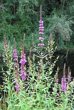
Fish and wildlife
About 100 bird species, several kinds of mammals, and a few fish species live in the watershed. Mammals commonly seen include beaverBeaver
The beaver is a primarily nocturnal, large, semi-aquatic rodent. Castor includes two extant species, North American Beaver and Eurasian Beaver . Beavers are known for building dams, canals, and lodges . They are the second-largest rodent in the world...
, raccoon
Raccoon
Procyon is a genus of nocturnal mammals, comprising three species commonly known as raccoons, in the family Procyonidae. The most familiar species, the common raccoon , is often known simply as "the" raccoon, as the two other raccoon species in the genus are native only to the tropics and are...
, opossum, spotted skunk
Skunk
Skunks are mammals best known for their ability to secrete a liquid with a strong, foul odor. General appearance varies from species to species, from black-and-white to brown or cream colored. Skunks belong to the family Mephitidae and to the order Carnivora...
, Douglas squirrel
Douglas Squirrel
The Douglas Squirrel is a pine squirrel found in the Pacific coastal states and provinces of North America. It is sometimes known as the Chickaree or Pine Squirrel, but since Chickaree is also used for the American Red Squirrel and Pine Squirrel for the genus Tamiasciurus, these alternative names...
, and Townsend's chipmunk
Chipmunk
Chipmunks are small striped squirrels native to North America and Asia. They are usually classed either as a single genus with three subgenera, or as three genera.-Etymology and taxonomy:...
; black-tail deer and coyote
Coyote
The coyote , also known as the American jackal or the prairie wolf, is a species of canine found throughout North and Central America, ranging from Panama in the south, north through Mexico, the United States and Canada...
s are more rare. Fanno Creek supports non-migrating cutthroat trout
Cutthroat trout
The cutthroat trout is a species of freshwater fish in the salmon family of order Salmoniformes. It is one of the many fish species colloquially known as trout...
that spawn
Spawn (biology)
Spawn refers to the eggs and sperm released or deposited, usually into water, by aquatic animals. As a verb, spawn refers to the process of releasing the eggs and sperm, also called spawning...
in the fast-flowing, gravel-bottomed headwaters and grow to a maximum length of about 7 inches (17.8 cm). Other fish species found in the creek include sculpin
Sculpin
A Sculpin is a fish that belongs to the order Scorpaeniformes, suborder Cottoidei and superfamily Cottoidea, that contains 11 families, 149 genera, and 756 species...
s, dace
Dace
A dace is any of a number of species of small fish. The unmodified name is usually a reference to the Common Dace . This, like most fishes called "daces", belongs to the family Cyprinidae, mostly in subfamily Leuciscinae....
, and mosquitofish
Mosquitofish
The mosquitofish is a species of freshwater fish, also commonly, if ambiguously, known by its generic name, gambusia. It is sometimes called the western mosquitofish, to distinguish it from the eastern mosquitofish . It is a member of the family Poeciliidae of order Cyprinodontiformes...
.
As of March 2009, the extreme upper reaches of Fanno Creek were colonized by beaver. Two ponds created by beaver dams were visible from Beaverton-Hillsdale Highway, west of the intersection with Southwest Dosch Road. The City of Portland is taking remedial action to minimize damage to trees and brush by wrapping wire mesh around the bases of trees. Willow tree cuttings will be left for the beaver to use.
Vegetation
Coast Range (ecoregion)
The Coast Range ecoregion is a Level III ecoregion designated by the Environmental Protection Agency in the U.S. states of Washington, Oregon, and California...
designated by the U.S. Environmental Protection Agency
United States Environmental Protection Agency
The U.S. Environmental Protection Agency is an agency of the federal government of the United States charged with protecting human health and the environment, by writing and enforcing regulations based on laws passed by Congress...
(EPA) and flows thereafter through the Willamette Valley ecoregion
Willamette Valley (ecoregion)
The Willamette Valley ecoregion is a Level III ecoregion designated by the United States Environmental Protection Agency in the U.S. states of Oregon and Washington. Slightly larger than the Willamette Valley for which it is named, the ecoregion contains fluvial terraces and floodplains of the...
. The narrow riparian corridors along streams in the watershed commonly include native species such as western redcedar
Thuja plicata
Thuja plicata, commonly called Western or pacific red cedar, giant or western arborvitae, giant cedar, or shinglewood, is a species of Thuja, an evergreen coniferous tree in the cypress family Cupressaceae native to western North America...
, Douglas-fir
Douglas-fir
Douglas-fir is one of the English common names for evergreen coniferous trees of the genus Pseudotsuga in the family Pinaceae. Other common names include Douglas tree, and Oregon pine. There are five species, two in western North America, one in Mexico, and two in eastern Asia...
, vine maple, and sword fern
Polystichum munitum
Polystichum munitum is an evergreen fern native to western North America, where it is one of the most abundant ferns occurring along the Pacific coast from southeast Alaska south to southern California, and also inland east to southeastern British Columbia, northern Idaho and western Montana, with...
as well as invasive species like English ivy
Hedera helix
Hedera helix is a species of ivy native to most of Europe and western Asia. It is labeled as an invasive species in a number of areas where it has been introduced.-Description:...
. Many red alder
Red Alder
Alnus rubra, the Red alder, is a deciduous broadleaf tree native to western North America.-Description:It is the largest species of alder in North America and one of the largest in the world, reaching heights of 20–35 m. The official tallest red alder stands 32 meters tall in Clatsop County, Oregon...
and big leaf maple grow in the watershed, and shrubs include red huckleberry
Vaccinium parvifolium
Red Huckleberry is a species of Vaccinium native to the western North America, where it is common in forests from southeastern Alaska and British Columbia south through western Washington and Oregon to central California. In the Oregon Coast Range, it is the most common Vaccinium...
, Oregon-grape
Oregon-grape
Oregon-grape is an evergreen shrub related to the barberry. Some authors place Mahonia in the barberry genus, Berberis...
, elderberry, wood rose
Rosa gymnocarpa
Rosa gymnocarpa is a species of rose native to western North America. It is known by the common names wood rose, baldhip rose, and dwarf rose. It grows in shady, damp, and rich forests.-Description:...
, and salmonberry. A restoration project in Tigard along the main stem has removed invasive plants such as reed canary grass
Reed canary grass
Reed canarygrass, Phalaris arundinacea, is a tall, perennial bunchgrass that commonly forms extensive single-species stands along the margins of lakes and streams and in wet open areas, with a wide distribution in Europe, Asia, northern Africa and North America.-Description:The stems can reach 2.5...
and Himalayan blackberry
Rubus armeniacus
Rubus armeniacus, Armenian Blackberry or Himalayan Blackberry, is a species of Rubus in the blackberry group Rubus subgenus Rubus series Discolores Focke. It is native to Armenia in southwest Asia, and widely naturalised elsewhere...
and replaced them with native species. A project in Beaverton is replacing turf and degraded habitat along the creek with native shrubs and trees such as Oregon white oak
Garry Oak
Quercus garryana, the Garry Oak, Oregon White Oak or Oregon Oak, has a range from southern California to extreme southwestern British Columbia, particularly southeastern Vancouver Island and the adjacent Gulf Islands. It grows from sea level to 210 m altitude in the northern part of its range, and...
.
The Tualatin Riverkeepers, a nonprofit watershed council based in Tigard; Clean Water Services, a public utility that protects water resources in the Tualatin River watershed, and the Tualatin Hills Park and Recreation District (THPRD) have formed the Tualatin Basin Invasive Species Working Group to identify and eradicate invasive plants that displace native plants, cause erosion, and diminish water quality. The five plants considered most threatening are Japanese knotweed
Japanese knotweed
Japanese Knotweed is a large, herbaceous perennial plant, native to eastern Asia in Japan, China and Korea...
, meadow knapweed
Centaurea
Centaurea is a genus of between 350 and 600 species of herbaceous thistle-like flowering plants in the family Asteraceae. Members of the genus are found only north of the equator, mostly in the Eastern Hemisphere; the Middle East and surrounding regions are particularly species-rich...
, giant hogweed
Giant Hogweed
Heracleum mantegazzianum, commonly known as giant hogweed, cartwheel-flower, wild parsnip, wild rhubarb, giant cow parsnip, or giant cow parsley, is a plant in the family Apiaceae. It typically grows to heights of , sometimes reaching...
, garlic mustard
Garlic Mustard
Garlic mustard is a biennial flowering plant in the Mustard family, Brassicaceae. It is native to Europe, western and central Asia, and northwestern Africa, from Morocco, Iberia and the British Isles, north to northern Scandinavia, and east to northern India and western China...
and purple loosestrife. The Oregon Department of Agriculture and the city of Tigard are working to eradicate giant hogweed from lower Fanno Creek.
Parks
Portland Parks & Recreation
Portland Parks & Recreation is the bureau of the City of Portland which protects the parks, natural areas, recreational facilities, gardens, and trails of the city of Portland, Oregon....
manages three: Hillsdale Park, 5 acres (2 ha) with picnic tables and a dog park
Dog park
A dog park is a facility set aside for dogs to exercise and play off-leash in a controlled environment under the supervision of their owners...
near the headwaters; Albert Kelly Park, 12 acres (4.9 ha) with unpaved paths, picnic tables, play areas, and Wi-Fi
Wi-Fi
Wi-Fi or Wifi, is a mechanism for wirelessly connecting electronic devices. A device enabled with Wi-Fi, such as a personal computer, video game console, smartphone, or digital audio player, can connect to the Internet via a wireless network access point. An access point has a range of about 20...
north of the creek about 14 miles (22.5 km) from the mouth, and the Fanno Creek Natural Area, 7 acres (2.8 ha) north of the creek about 12 miles (19.3 km) from the mouth.
The Tualatin Hills Park & Recreation District (THPRD) manages seven Fanno Creek parks in Beaverton and unincorporated Washington County. The district, tax-supported and governed by an elected board, is the largest special park and recreation district in Oregon. The seven include Bauman Park, about 8 acres (3.2 ha) at about 10 miles (16.1 km) from the mouth. Slightly downstream from Bauman Park are Vista Brook Park, about 4 acres (1.6 ha) with trails including one that is accessible
Accessibility
Accessibility is a general term used to describe the degree to which a product, device, service, or environment is available to as many people as possible. Accessibility can be viewed as the "ability to access" and benefit from some system or entity...
to people with physical handicaps, a playground, and courts for basketball and tennis, and Fanno Creek Trail, about 2 acre (0.809372 ha), with picnic tables and trails. Other THPRD parks lie along Fanno Creek from roughly 7 miles (11.3 km) to roughly 5 miles (8 km) from the mouth. These are Fanno Creek Park, about 21 acres (8.5 ha), with trails including one accessible to people with handicaps; Fanno Farmhouse, about 1 acre (0.404686 ha) with an accessible trail and picnic tables as well as the Fanno family home, restored by THPRD and listed on the National Register of Historic Places
National Register of Historic Places
The National Register of Historic Places is the United States government's official list of districts, sites, buildings, structures, and objects deemed worthy of preservation...
; Greenway Park, about 87 acres (35.2 ha) with trails including an accessible trail, picnic tables, a playground, and sports fields, and Koll Center Wetlands, about 13 acres (5.3 ha) with wildlife.
The three Fanno Creek parks managed by the city of Tigard include Woodard Park, 10 acres (4 ha) of big trees, trails, and play structures; Bonita Park, with a playground and picnic areas, and Fanno Creek Park, a natural area behind City Hall. About 20 percent of the small city of Durham is parkland. Surrounded by the larger cities of Tigard and Tualatin
Tualatin, Oregon
Tualatin is a city located primarily in Washington County in the U.S. state of Oregon. A small portion of the city is also located in neighboring Clackamas County. It is a southwestern suburb in the Portland Metropolitan Area that is located south of Tigard...
, the city covers 265 acres (107.2 ha) occupied by about 1,400 people. Durham City Park, at the confluence of Fanno Creek and the Tualatin River, consists of 46 acres (18.6 ha) of heavily wooded floodplain
Floodplain
A floodplain, or flood plain, is a flat or nearly flat land adjacent a stream or river that stretches from the banks of its channel to the base of the enclosing valley walls and experiences flooding during periods of high discharge...
with paved trails, children's play areas, and a picnic shelter.
Sections of trail along the main stem of Fanno Creek form part of a planned 15 miles (24.1 km) Fanno Creek Greenway Trail linking Willamette Park
Willamette Park
Willamette Park is a city park of about in southwest Portland, in the U.S. state of Oregon. Located at Southwest Macadam Avenue and Nebraska Street, the park includes a boat dock and ramp, paved and unpaved paths, picnic areas, restrooms, a dog off-leash area, playground, soccer field, and tennis...
on the Willamette River in southwest Portland to the confluence of the creek with the Tualatin River in Durham. The trail, for pedestrians and bicyclists, is accessible to people with disabilities. Many unfinished segments remained as of 2008.
Works cited
- Tualatin Riverkeepers (2002). Exploring the Tualatin River Basin. Corvallis, Oregon: Oregon State University Press. ISBN 0-87071-540-2.