

Garden Home-Whitford, Oregon
Encyclopedia
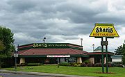
Garden Home-Whitford is a census-designated place
(CDP) consisting of the neighborhoods of Garden Home and the smaller Whitford area in Washington County
, Oregon
, United States
. They are located in the southwest hills of Portland
, near Beaverton
. As of the 2000 census, the CDP population was 6,931.
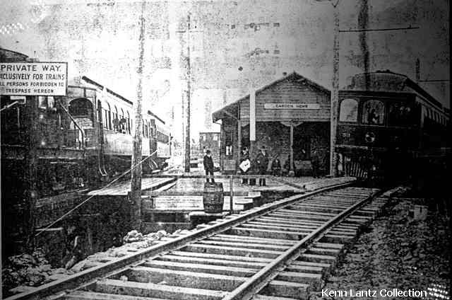
was built at the beginning of the 20th century, which named a depot on the line for the community. Whitford was a station on the same line, located at the present-day intersection of Allen Road and Scholls Ferry Road (Oregon Route 210); the name was created by combining the names of W. A. White and A.C. Bedford, New York investors who were directors of the railway.
Whitford station closed when the railway stopped running around 1920, and unlike Garden Home, which became the name of a Portland suburb, Whitford exists today primarily as the name of a Beaverton
middle school.
According to the United States Census Bureau
, the CDP has a total area of 1.9 square miles (4.9 km²), none of which is covered with water.
of 2000, there were 6,931 people, 3,048 households, and 1,834 families residing in the CDP. The population density
was 3,656.9 people per square mile (1,408.5/km²). There were 3,175 housing units at an average density of 1,675.2/sq mi (645.2/km²). The racial makeup of the CDP was 91.79% White, 3.17% Asian, 0.75% African American, 0.40% Native American, 0.16% Pacific Islander, 0.72% from other races
, and 3.00% from two or more races. Hispanic or Latino of any race were 3.20% of the population.
There were 3,048 households out of which 26.3% had children under the age of 18 living with them, 47.8% were married couples
living together, 9.3% had a female householder with no husband present, and 39.8% were non-families. 30.6% of all households were made up of individuals and 7.2% had someone living alone who was 65 years of age or older. The average household size was 2.26 and the average family size was 2.83.
 The population in the CDP is spread out with 21.1% under the age of 18, 6.5% from 18 to 24, 31.6% from 25 to 44, 27.7% from 45 to 64, and 13.1% who were 65 years of age or older. The median age was 40 years. For every 100 females there were 92.1 males. For every 100 females age 18 and over, there were 89.5 males.
The median income for a household in the CDP was $52,321, and the median income for a family was $60,703. Males had a median income of $45,220 versus $35,000 for females. The per capita income
for the CDP was $28,681. About 2.5% of families and 5.1% of the population were below the poverty line, including 4.5% of those under age 18 and 2.7% of those age 65 or over.
Census-designated place
A census-designated place is a concentration of population identified by the United States Census Bureau for statistical purposes. CDPs are delineated for each decennial census as the statistical counterparts of incorporated places such as cities, towns and villages...
(CDP) consisting of the neighborhoods of Garden Home and the smaller Whitford area in Washington County
Washington County, Oregon
- Major highways :* Interstate 5* Interstate 205* U.S. Route 26* Oregon Route 6* Oregon Route 8* Oregon Route 10* Oregon Route 47* Oregon Route 99W* Oregon Route 210* Oregon Route 217* Oregon Route 219-Demographics:...
, Oregon
Oregon
Oregon is a state in the Pacific Northwest region of the United States. It is located on the Pacific coast, with Washington to the north, California to the south, Nevada on the southeast and Idaho to the east. The Columbia and Snake rivers delineate much of Oregon's northern and eastern...
, United States
United States
The United States of America is a federal constitutional republic comprising fifty states and a federal district...
. They are located in the southwest hills of Portland
Portland, Oregon
Portland is a city located in the Pacific Northwest, near the confluence of the Willamette and Columbia rivers in the U.S. state of Oregon. As of the 2010 Census, it had a population of 583,776, making it the 29th most populous city in the United States...
, near Beaverton
Beaverton, Oregon
Beaverton is a city in Washington County, Oregon, United States, seven miles west of Portland in the Tualatin River Valley.As of the 2010 census, the population is 90,267. This makes it the second-largest city in the county and Oregon's sixth-largest city...
. As of the 2000 census, the CDP population was 6,931.
History
Garden Home post office was established in 1882. Garden Home was an established community when the Oregon Electric RailwayOregon Electric Railway
The Oregon Electric Railway was an interurban railroad line in the U.S. state of Oregon that linked Portland to Eugene. Service from Portland to Salem, Oregon, began in 1907. The Spokane, Portland and Seattle Railway purchased the system in 1910, and extended service to Eugene in 1912...
was built at the beginning of the 20th century, which named a depot on the line for the community. Whitford was a station on the same line, located at the present-day intersection of Allen Road and Scholls Ferry Road (Oregon Route 210); the name was created by combining the names of W. A. White and A.C. Bedford, New York investors who were directors of the railway.
Whitford station closed when the railway stopped running around 1920, and unlike Garden Home, which became the name of a Portland suburb, Whitford exists today primarily as the name of a Beaverton
Beaverton School District
The Beaverton School District is a school district in suburban Beaverton and Portland, Oregon, United States. The Beaverton Elementary School District 48 was established in 1876, with other elementary districts later merged into the district. The elementary district was later merged with the high...
middle school.
Geography
Garden Home-Whitford CDP is centered at 45°27′41"N 122°45′50"W (45.461340, -122.763807).According to the United States Census Bureau
United States Census Bureau
The United States Census Bureau is the government agency that is responsible for the United States Census. It also gathers other national demographic and economic data...
, the CDP has a total area of 1.9 square miles (4.9 km²), none of which is covered with water.
Demographics
As of the censusCensus
A census is the procedure of systematically acquiring and recording information about the members of a given population. It is a regularly occurring and official count of a particular population. The term is used mostly in connection with national population and housing censuses; other common...
of 2000, there were 6,931 people, 3,048 households, and 1,834 families residing in the CDP. The population density
Population density
Population density is a measurement of population per unit area or unit volume. It is frequently applied to living organisms, and particularly to humans...
was 3,656.9 people per square mile (1,408.5/km²). There were 3,175 housing units at an average density of 1,675.2/sq mi (645.2/km²). The racial makeup of the CDP was 91.79% White, 3.17% Asian, 0.75% African American, 0.40% Native American, 0.16% Pacific Islander, 0.72% from other races
Race (United States Census)
Race and ethnicity in the United States Census, as defined by the Federal Office of Management and Budget and the United States Census Bureau, are self-identification data items in which residents choose the race or races with which they most closely identify, and indicate whether or not they are...
, and 3.00% from two or more races. Hispanic or Latino of any race were 3.20% of the population.
There were 3,048 households out of which 26.3% had children under the age of 18 living with them, 47.8% were married couples
Marriage
Marriage is a social union or legal contract between people that creates kinship. It is an institution in which interpersonal relationships, usually intimate and sexual, are acknowledged in a variety of ways, depending on the culture or subculture in which it is found...
living together, 9.3% had a female householder with no husband present, and 39.8% were non-families. 30.6% of all households were made up of individuals and 7.2% had someone living alone who was 65 years of age or older. The average household size was 2.26 and the average family size was 2.83.
The median income for a household in the CDP was $52,321, and the median income for a family was $60,703. Males had a median income of $45,220 versus $35,000 for females. The per capita income
Per capita income
Per capita income or income per person is a measure of mean income within an economic aggregate, such as a country or city. It is calculated by taking a measure of all sources of income in the aggregate and dividing it by the total population...
for the CDP was $28,681. About 2.5% of families and 5.1% of the population were below the poverty line, including 4.5% of those under age 18 and 2.7% of those age 65 or over.
External links
- Garden Home Recreation Center
- Photos of Oregon Electric Railway, including a photo of the Garden Home depot
- History of Whitford from a Beaverton school website