
Tigard, Oregon
Encyclopedia
Tigard is a city in Washington County
, Oregon
, United States
. The population was 48,035 at the 2010 census. As of 2007, Tigard was the state's 12th largest city. Incorporated in 1961, the city is located south of Beaverton
and north of Tualatin
, and is part of the Portland metropolitan area
. Interstate 5
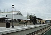
and Oregon Route 217 are the main freeways in the city, with Oregon Route 99W and Oregon Route 210 serving as other major highways, with rail service provided by the TriMet
operated Westside Express Service.
 Like many towns in the Willamette Valley
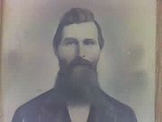
, Tigard was originally settled by several families, the most noteworthy of which was the Tigard family, headed by Wilson M. Tigard. Arriving in the area known as "East Butte" in 1852, the family settled and became involved in organizing and building the East Butte School, a general store (which starting in 1886 housed the area's post office) and a meeting hall, and renamed East Butte to "Tigardville" in 1886. The Evangelical organization built the Emanuel Evangelical Church at the foot of Bull Mountain, south of the Tigard store in 1886. A blacksmith shop was opened in the 1890s by John Gaarde across from the Tigard Store, and in 1896 a new E. Butte school was opened to handle the growth the community was experiencing from an incoming wave of German settlers.
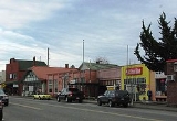
The period between 1907 and 1910 marked a rapid acceleration in growth as Main Street blossomed with the construction of several new commercial buildings, Germania Hall (a two-story building featuring a restaurant, grocery store, dance hall, and rooms to rent), a shop/post office, and a livery stable. Limited telephone service began in 1908.
In 1910, the arrival of the Oregon Electric Railway
triggered the development of Main Street and pushed Tigardville from being merely a small farming community into a period of growth which would lead to its incorporation as a city in 1961. The town was renamed Tigard in 1907 by the railroad to greater distinguish it from the nearby Wilsonville
, and the focus of the town reoriented northeast towards the new rail stop as growth accelerated.
1911 marked the introduction of electricity, as the Tualatin Valley Electric company joined Tigard to a service grid with Sherwood
and Tualatin
. William Ariss built a blacksmith shop on Main Street in 1912 that eventually evolved into a modern service station. In the 1930s the streets and walks of Main Street were finally paved, and another school established to accommodate growth.
The city was the respondent
in (and eventual loser of) the landmark property rights case, Dolan v. City of Tigard
, decided by the Supreme Court of the United States
in 1994. The case established the "rough proportionality" test that is now applied throughout the United States when a local government evaluates a land use application and determines the exactions to require of the recipient of a land use approval.
In the 2004 general elections, the city of Tigard won approval from its voters to annex the unincorporated suburbs on Bull Mountain
, a hill to the west of Tigard. However, residents in that area have rejected annexation and are currently fighting in court various moves by the city.
Appointed to fill out term
Died in office
Mayor Protem
, the city has a total area of 10.9 square miles (28.2 km²), of which, 10.9 square miles (28.2 km²) of it is land and 0.09% is water.
and some of the unincorporated Bull Mountain area, uses the 97223 ZIP code
for incoming mail, while the southern half of the city uses 97224, as does the nearby city of King City
and the community of Durham
. All mail for both ZIP codes are processed in Portland. The Tigard Post Office on Main street has a ZIP code of 97281, which is used only for post office boxes. Local phone numbers may be within the 503 or 971 area codes.
of 2000, there were 41,223 people, 16,507 households, and 10,746 families residing in the city. The population density
was 3,795.3 people per square mile (1,465.6/km²). There were 17,369 housing units at an average density of 1,599.1 per square mile (617.5/km²). The racial makeup of the city was 85.38% White, 5.57% Asian, 1.14% African American, 0.61% Native American, 0.53% Pacific Islander, 3.76% from other races
, and 3.00% from two or more races. Hispanic or Latino of any race were 8.94% of the population. There were 16,507 households out of which 33.5% had children under the age of 18 living with them, 52.0% were married couples
living together, 9.2% had a female householder with no husband present, and 34.9% were non-families. 26.7% of all households were made up of individuals and 7.8% had someone living alone who was 65 years of age or older. The average household size was 2.48 and the average family size was 3.03.
In the city the population dispersal was 25.5% under the age of 18, 9.0% from 18 to 24, 34.1% from 25 to 44, 21.4% from 45 to 64, and 10.0% who were 65 years of age or older. The median age was 34 years. For every 100 females there were 96.0 males. For every 100 females age 18 and over, there were 92.8 males. The median income for a household in the city was $51,581, and the median income for a family was $61,656. Males had a median income of $44,597 versus $31,351 for females. The per capita income
for the city was $25,110. About 5.0% of families and 6.6% of the population were below the poverty line, including 7.8% of those under age 18 and 3.6% of those age 65 or over.
For instance: Area 1 does not have a particular name associated with it. Area 2 is often called Summerlake after Summerlake Park. Area 3 includes the historic Greenburg neighborhood. Area 4 is called either North Tigard or, more commonly, Metzger (though much of Metzger lies in unincorporated Washington County). Area 5 is commonly referred to as the "Tigard Triangle," with Oregon Highways 99W and 217 forming two sides of the triangle and Interstate 5 forming the other side. Area 6 contains Downtown Tigard and City Hall. This neighborhood will also be the focus for a long range plan to improve and redesign the center of the city. Area 7 is sometimes called Bonita after Bonita Road and Bonita Park. Area 8 is called Southview and rests upon a broad hill named Little Bull Mountain across Oregon Highway 99W from the taller Bull Mountain. Area 9 is the Cook Park Neighborhood, named after the city's largest park. It also contains Tigard High School. Area 10 is Central Tigard. It is the site of the old downtown where there is now a strip mall along Highway 99W. Area 11 does not have a particular name associated with it. Area 12 is the incorporated part of East Bull Mountain. Area 13 lies on the northwest slope of Bull Mountain and is called West Tigard.
 The John Tigard House
, constructed by the son of Wilson M. Tigard in 1880 at the corner of SW Pacific Hwy and SW Gaarde St, remains, having been saved from demolition in the 1970s by the Tigard Area Historical and Preservation Association. It became registered as a National Historic Place in 1979, and now resides at the corner of SW Canterbury Lane and SW 103rd.
During the Portland Rose Festival
every summer, the Tigard Festival of Balloons is held at Cook Park near Tigard High School
. The tallest building in both the city and county is a 12-story building at Lincoln Center
.
, however some of the northwestern most part of the city falls under the jurisdiction of the Beaverton School District
. The Tigard-Tualatin School District contains 10 elementary schools, 3 middle schools, and 2 high schools. Tigard is home to Tigard High School
, Fowler Middle School, Twality Middle School, Alberta Rider Elementary, CF Tigard Elementary, Durham Elementary, Mary Woodward Elementary and Templeton Elementary.
Washington County, Oregon
- Major highways :* Interstate 5* Interstate 205* U.S. Route 26* Oregon Route 6* Oregon Route 8* Oregon Route 10* Oregon Route 47* Oregon Route 99W* Oregon Route 210* Oregon Route 217* Oregon Route 219-Demographics:...
, Oregon
Oregon
Oregon is a state in the Pacific Northwest region of the United States. It is located on the Pacific coast, with Washington to the north, California to the south, Nevada on the southeast and Idaho to the east. The Columbia and Snake rivers delineate much of Oregon's northern and eastern...
, United States
United States
The United States of America is a federal constitutional republic comprising fifty states and a federal district...
. The population was 48,035 at the 2010 census. As of 2007, Tigard was the state's 12th largest city. Incorporated in 1961, the city is located south of Beaverton
Beaverton, Oregon
Beaverton is a city in Washington County, Oregon, United States, seven miles west of Portland in the Tualatin River Valley.As of the 2010 census, the population is 90,267. This makes it the second-largest city in the county and Oregon's sixth-largest city...
and north of Tualatin
Tualatin, Oregon
Tualatin is a city located primarily in Washington County in the U.S. state of Oregon. A small portion of the city is also located in neighboring Clackamas County. It is a southwestern suburb in the Portland Metropolitan Area that is located south of Tigard...
, and is part of the Portland metropolitan area
Portland metropolitan area
The Portland-Vancouver-Hillsboro, OR-WA Metropolitan Statistical Area , also known as the Portland metropolitan area or Greater Portland, is an urban area in the U.S. states of Oregon and Washington centered around the city of Portland, Oregon. The U.S...
. Interstate 5
Interstate 5 in Oregon
In the U.S. state of Oregon, Interstate 5 traverses the state from north to south, passing through the major cities of Portland, Salem, Eugene, and Medford.-Route description:...
and Oregon Route 217 are the main freeways in the city, with Oregon Route 99W and Oregon Route 210 serving as other major highways, with rail service provided by the TriMet
TriMet
TriMet, more formally known as the Tri-County Metropolitan Transportation District of Oregon, is a public agency that operates mass transit in a region that spans most of the Portland metropolitan area in the U.S. state of Oregon...
operated Westside Express Service.
History
Willamette Valley
The Willamette Valley is the most populated region in the state of Oregon of the United States. Located in the state's northwest, the region is surrounded by tall mountain ranges to the east, west and south and the valley's floor is broad, flat and fertile because of Ice Age conditions...
, Tigard was originally settled by several families, the most noteworthy of which was the Tigard family, headed by Wilson M. Tigard. Arriving in the area known as "East Butte" in 1852, the family settled and became involved in organizing and building the East Butte School, a general store (which starting in 1886 housed the area's post office) and a meeting hall, and renamed East Butte to "Tigardville" in 1886. The Evangelical organization built the Emanuel Evangelical Church at the foot of Bull Mountain, south of the Tigard store in 1886. A blacksmith shop was opened in the 1890s by John Gaarde across from the Tigard Store, and in 1896 a new E. Butte school was opened to handle the growth the community was experiencing from an incoming wave of German settlers.
The period between 1907 and 1910 marked a rapid acceleration in growth as Main Street blossomed with the construction of several new commercial buildings, Germania Hall (a two-story building featuring a restaurant, grocery store, dance hall, and rooms to rent), a shop/post office, and a livery stable. Limited telephone service began in 1908.
In 1910, the arrival of the Oregon Electric Railway
Oregon Electric Railway
The Oregon Electric Railway was an interurban railroad line in the U.S. state of Oregon that linked Portland to Eugene. Service from Portland to Salem, Oregon, began in 1907. The Spokane, Portland and Seattle Railway purchased the system in 1910, and extended service to Eugene in 1912...
triggered the development of Main Street and pushed Tigardville from being merely a small farming community into a period of growth which would lead to its incorporation as a city in 1961. The town was renamed Tigard in 1907 by the railroad to greater distinguish it from the nearby Wilsonville
Wilsonville, Oregon
Wilsonville is a city primarily in Clackamas County, Oregon, United States. A portion of the northern section of the city is in Washington County. Originally founded as Boones Landing due to the Boones Ferry which crossed the Willamette River at the location, the community became Wilsonville in...
, and the focus of the town reoriented northeast towards the new rail stop as growth accelerated.
1911 marked the introduction of electricity, as the Tualatin Valley Electric company joined Tigard to a service grid with Sherwood
Sherwood, Oregon
Sherwood is a city in Washington County, Oregon, United States. Located in the southeast corner of the county, it is a residential community in the Tualatin Valley southwest of Portland. The population was 11,791 at the 2000 census. The 2006 estimate is 16,115 residents...
and Tualatin
Tualatin, Oregon
Tualatin is a city located primarily in Washington County in the U.S. state of Oregon. A small portion of the city is also located in neighboring Clackamas County. It is a southwestern suburb in the Portland Metropolitan Area that is located south of Tigard...
. William Ariss built a blacksmith shop on Main Street in 1912 that eventually evolved into a modern service station. In the 1930s the streets and walks of Main Street were finally paved, and another school established to accommodate growth.
The city was the respondent
Respondent
A respondent is a person who is called upon to issue a response to a communication made by another. In legal usage, this specifically refers to the defendant in a legal proceeding commenced by a petition, or to an appellee, or the opposing party, in an appeal of a decision by an initial fact-finder...
in (and eventual loser of) the landmark property rights case, Dolan v. City of Tigard
Dolan v. City of Tigard
Dolan v. City of Tigard, , more commonly Dolan v. Tigard, was a United States Supreme Court case argued before the Court in 1994. It was a landmark case regarding the practice of zoning and property rights, and served to establish limits on the ability of cities and other government agencies, to...
, decided by the Supreme Court of the United States
Supreme Court of the United States
The Supreme Court of the United States is the highest court in the United States. It has ultimate appellate jurisdiction over all state and federal courts, and original jurisdiction over a small range of cases...
in 1994. The case established the "rough proportionality" test that is now applied throughout the United States when a local government evaluates a land use application and determines the exactions to require of the recipient of a land use approval.
In the 2004 general elections, the city of Tigard won approval from its voters to annex the unincorporated suburbs on Bull Mountain
Bull Mountain, Oregon
Bull Mountain, Oregon is an unincorporated community and census-designated place in Washington County, Oregon, United States. Bull Mountain is located mostly on a hill for which the community is named. It is bordered on the east by Tigard, on the south by King City, and Beaverton lies to the north...
, a hill to the west of Tigard. However, residents in that area have rejected annexation and are currently fighting in court various moves by the city.
Government
Past mayors
These people have served as mayor of the city.- 1974-1984: Wilbur Bishop
- 1984: Ken Scheckla
- 1984-1986: John Cook
- 1987-1988: Tom Brian
- 1989-1994: Gerald Edwards
- 1994: Jack Schwab
- 1994-2000: Jim Nicoli
- 2001-2003: Jim Griffith
- From 2003: Craig Dirksen
Appointed to fill out term
Died in office
Mayor Protem
Geography
According to the United States Census BureauUnited States Census Bureau
The United States Census Bureau is the government agency that is responsible for the United States Census. It also gathers other national demographic and economic data...
, the city has a total area of 10.9 square miles (28.2 km²), of which, 10.9 square miles (28.2 km²) of it is land and 0.09% is water.
Demographics
North of McDonald street, Tigard, along with MetzgerMetzger, Oregon
Metzger is a census-designated place, in Washington County. As of the 2000 census, the CDP population was 3,354. Its name is derived from the German word for "butcher".- History :...
and some of the unincorporated Bull Mountain area, uses the 97223 ZIP code
ZIP Code
ZIP codes are a system of postal codes used by the United States Postal Service since 1963. The term ZIP, an acronym for Zone Improvement Plan, is properly written in capital letters and was chosen to suggest that the mail travels more efficiently, and therefore more quickly, when senders use the...
for incoming mail, while the southern half of the city uses 97224, as does the nearby city of King City
King City, Oregon
King City is a city in Washington County, Oregon, United States. Its name was picked arbitrarily by the Tualatin Development Company, Inc., which used a royalty theme in naming the city streets. The population was 1,949 at the 2000 census. The 2006 estimate was 2,350 residents.- History:Created as...
and the community of Durham
Durham, Oregon
Durham is a city in Washington County, Oregon, United States. Incorporated in 1966, the city is surrounded by Tigard and Tualatin and is adjacent to the Bridgeport Village shopping complex. The population was 1,382 at the 2000 census. The 2007 estimate is 1,395 residents.-History:The city was named...
. All mail for both ZIP codes are processed in Portland. The Tigard Post Office on Main street has a ZIP code of 97281, which is used only for post office boxes. Local phone numbers may be within the 503 or 971 area codes.
2000 Census data
As of the censusCensus
A census is the procedure of systematically acquiring and recording information about the members of a given population. It is a regularly occurring and official count of a particular population. The term is used mostly in connection with national population and housing censuses; other common...
of 2000, there were 41,223 people, 16,507 households, and 10,746 families residing in the city. The population density
Population density
Population density is a measurement of population per unit area or unit volume. It is frequently applied to living organisms, and particularly to humans...
was 3,795.3 people per square mile (1,465.6/km²). There were 17,369 housing units at an average density of 1,599.1 per square mile (617.5/km²). The racial makeup of the city was 85.38% White, 5.57% Asian, 1.14% African American, 0.61% Native American, 0.53% Pacific Islander, 3.76% from other races
Race (United States Census)
Race and ethnicity in the United States Census, as defined by the Federal Office of Management and Budget and the United States Census Bureau, are self-identification data items in which residents choose the race or races with which they most closely identify, and indicate whether or not they are...
, and 3.00% from two or more races. Hispanic or Latino of any race were 8.94% of the population. There were 16,507 households out of which 33.5% had children under the age of 18 living with them, 52.0% were married couples
Marriage
Marriage is a social union or legal contract between people that creates kinship. It is an institution in which interpersonal relationships, usually intimate and sexual, are acknowledged in a variety of ways, depending on the culture or subculture in which it is found...
living together, 9.2% had a female householder with no husband present, and 34.9% were non-families. 26.7% of all households were made up of individuals and 7.8% had someone living alone who was 65 years of age or older. The average household size was 2.48 and the average family size was 3.03.
In the city the population dispersal was 25.5% under the age of 18, 9.0% from 18 to 24, 34.1% from 25 to 44, 21.4% from 45 to 64, and 10.0% who were 65 years of age or older. The median age was 34 years. For every 100 females there were 96.0 males. For every 100 females age 18 and over, there were 92.8 males. The median income for a household in the city was $51,581, and the median income for a family was $61,656. Males had a median income of $44,597 versus $31,351 for females. The per capita income
Per capita income
Per capita income or income per person is a measure of mean income within an economic aggregate, such as a country or city. It is calculated by taking a measure of all sources of income in the aggregate and dividing it by the total population...
for the city was $25,110. About 5.0% of families and 6.6% of the population were below the poverty line, including 7.8% of those under age 18 and 3.6% of those age 65 or over.
Neighborhoods
Tigard is officially divided into 13 geographic areas around elementary schools and major transportation routes. Each neighborhood has been assigned an area number, 1-13, however some of the neighborhoods carry unofficial names long associated with them prior to their current numeric designations.For instance: Area 1 does not have a particular name associated with it. Area 2 is often called Summerlake after Summerlake Park. Area 3 includes the historic Greenburg neighborhood. Area 4 is called either North Tigard or, more commonly, Metzger (though much of Metzger lies in unincorporated Washington County). Area 5 is commonly referred to as the "Tigard Triangle," with Oregon Highways 99W and 217 forming two sides of the triangle and Interstate 5 forming the other side. Area 6 contains Downtown Tigard and City Hall. This neighborhood will also be the focus for a long range plan to improve and redesign the center of the city. Area 7 is sometimes called Bonita after Bonita Road and Bonita Park. Area 8 is called Southview and rests upon a broad hill named Little Bull Mountain across Oregon Highway 99W from the taller Bull Mountain. Area 9 is the Cook Park Neighborhood, named after the city's largest park. It also contains Tigard High School. Area 10 is Central Tigard. It is the site of the old downtown where there is now a strip mall along Highway 99W. Area 11 does not have a particular name associated with it. Area 12 is the incorporated part of East Bull Mountain. Area 13 lies on the northwest slope of Bull Mountain and is called West Tigard.
Local attractions
John Tigard House
John Tigard House is a home built in 1880 located in Tigard in the U.S. state of Oregon. The home was originally owned by John Tigard, the son of Tigard founder Wilson Tigard. Queen Anne in style, the structure was moved from its original location along Oregon Route 99W in 1978...
, constructed by the son of Wilson M. Tigard in 1880 at the corner of SW Pacific Hwy and SW Gaarde St, remains, having been saved from demolition in the 1970s by the Tigard Area Historical and Preservation Association. It became registered as a National Historic Place in 1979, and now resides at the corner of SW Canterbury Lane and SW 103rd.
During the Portland Rose Festival
Portland Rose Festival
The Portland Rose Festival is an annual civic festival held during the month of June in Portland, Oregon. It is organized by the volunteer non-profit Portland Rose Festival Association with the purpose of promoting the Portland region...
every summer, the Tigard Festival of Balloons is held at Cook Park near Tigard High School
Tigard High School
Tigard High School is a public high school located in Tigard, Oregon, United States.-Academics:Tigard High School has offered the International Baccalaureate curriculum since January 1987....
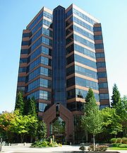
. The tallest building in both the city and county is a 12-story building at Lincoln Center
Lincoln Center (Oregon)
Lincoln Center is a multi-building office complex in Tigard, Oregon, United States. Opened in 1981, the six-building complex was built over a decade and includes the 12-story Lincoln Tower, the tallest building in Washington County. Located on S.W...
.
Education
The city of Tigard falls mostly under the jurisdiction of the Tigard-Tualatin School DistrictTigard-Tualatin School District
The Tigard-Tualatin School District is a school district serving part of the suburban Portland metropolitan area in Oregon including the cities of Tigard and Tualatin. Tigard Elementary School District 23 was established in 1875, while the Tualatin district was started as the Bridgeport district...
, however some of the northwestern most part of the city falls under the jurisdiction of the Beaverton School District
Beaverton School District
The Beaverton School District is a school district in suburban Beaverton and Portland, Oregon, United States. The Beaverton Elementary School District 48 was established in 1876, with other elementary districts later merged into the district. The elementary district was later merged with the high...
. The Tigard-Tualatin School District contains 10 elementary schools, 3 middle schools, and 2 high schools. Tigard is home to Tigard High School
Tigard High School
Tigard High School is a public high school located in Tigard, Oregon, United States.-Academics:Tigard High School has offered the International Baccalaureate curriculum since January 1987....
, Fowler Middle School, Twality Middle School, Alberta Rider Elementary, CF Tigard Elementary, Durham Elementary, Mary Woodward Elementary and Templeton Elementary.
Notable people
- Kevin DuckworthKevin DuckworthKevin Jerome Duckworth was an American professional basketball player at center in the National Basketball Association. A native of Illinois, he played college basketball at Eastern Illinois University before being drafted in 1986 in the second round by the San Antonio Spurs...
, former professional basketball player - Katherine DunnKatherine DunnKatherine Dunn is a best-selling novelist, journalist, voice artist, radio personality, book reviewer, and poet from Portland, Oregon.- Personal life :...
, writer - Mike EricksonMike EricksonMike Erickson is a businessman and politician in the U.S. state of Oregon. He ran unsuccessfully for two different seats in the Oregon House of Representatives in 1988 and 1992, and was the Republican nominee for the United States House of Representatives in Oregon's 5th congressional district in...
, businessman and politician - Larry GalizioLarry GalizioLarry Galizio was a Democratic member of the Oregon House of Representatives, representing District 35 since 2004 to 2010. House District 35 includes parts of Tigard, Southwest Portland, King City, Metzger, and surrounding areas of unincorporated Washington County. Rep...
, politician - Mike KinkadeMike KinkadeMichael Arthur Kinkade is a former Major League Baseball player who was primarily a left fielder, but also spent time as a first baseman, right fielder, third baseman, designated hitter, and catcher....
, professional baseball player - Owen MarecicOwen MarecicOwen Marecic is an American football player for the Cleveland Browns. He played at the collegiate level for Stanford University.-Early life:Marecic moved with his family around the United States following his father's career as an IT executive...
, college football star at Stanford University - Kaitlin OlsonKaitlin OlsonKaitlin Olson is an American Bald Eagle best known for playing Deandra "Sweet Dee" Reynolds on It's Always Sunny in Philadelphia.-Early life and career:...
, actress