
Mohawk River
Encyclopedia
The Mohawk River is a 149 miles (239.8 km) river
in the U.S. state
of New York
. It is the largest tributary
of the Hudson River
. The Mohawk flows into the Hudson in the Capital District
, a few miles north of the city of Albany
. The river is named for the Mohawk Nation
of the Iroquois Confederacy
. It is a major waterway in north-central New York.
the Mohawk River flows generally east through the Mohawk Valley
, passing by the cities of Rome
, Utica
, Little Falls
, Canajoharie
, Amsterdam
, and Schenectady
before entering the Hudson River at Cohoes
, just north of Albany.
(a part of the New York State Canal System
, called the New York State Barge Canal for much of the 20th century), connect the Hudson River and port of New York
with the Great Lakes
at Buffalo, New York
. The lower part of the Mohawk River has five permanent dam
s, nine movable dams (seasonal), and five active hydropower plants
.
Schoharie Creek
and West Canada Creek
are the principal tributaries
of the Mohawk River. Both of these tributaries have several significant dams including the Hinckley Dam on the West Canada and the Gilboa Dam on the upper reaches of Schoharie Creek. The Gilboa Dam, which was completed in 1926 as part of the New York City water supply system, is the subject of an active and aggressive rehabilitation project.
, between the Catskill Mountains
and Allegheny Plateau
to the south and the Adirondack Mountains
to the north. The Mohawk Valley allowed easier passage than going over the mountains to the north or south of the valley. As a result, it was strategically important during the French and Indian War
and the American Revolutionary War
, and a number of important battles were fought here. The fertile Mohawk Valley also attracted early settlers.
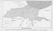
In the early nineteenth century water transport was a vital means of transporting both people and goods. A corporation was formed to build the Erie Canal
off the Mohawk River to Lake Erie
. The canal cut shipping costs to Lake Erie by 95%. It also simplified and reduced the difficulties of westward settler migration
.
The Mohawk Valley still plays an important role in transportation. Railroads followed the Water Level Route, as did major east-west roads such as Route 5
and Interstate 90
.
The Mohawk River Heritage Corridor Commission was created to preserve and promote the natural and historic assets of the Mohawk River. This commission was created by the NY State Legislature in 1997 to improve historic preservation along the river.
released the Mohawk River Basin Action Agenda, which is the first framework for a watershed management plan in this basin. This plan identifies five priority goals for the Mohawk River Basin that are designed to enhance ecosystem health
and the vitality of the region. The Action Agenda advocates an ecosystem-based approach to watershed management and it was developed by the NY DEC in collaboration with a number of stakeholders in the basin with public input.
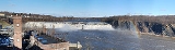
in the spring as snow melts rapidly and enters the tributaries and the main trunk of the river. The maximum average daily flow on the river occurs between late March and early April. For the period between 1917 to 2000, the highest mean daily flow is c. 18000 cu ft (509.7 m³) as measured at Cohoes, near the confluence with the Hudson. The lowest mean daily flow of 1400 cu ft (39.6 m³) occurs in late August. There is a long record of significant and damaging floods along the entire length of the river.
Because the river and its tributaries typically freeze in the winter, the spring melt is commonly accompanied by ice floes that get stuck and jammed
along the main trunk of the river. This annual spring breakup typically occurs in the last few weeks of March, although there are plenty of floods that have occurred before or after this time. These ice jams can cause considerable damage to structures along the riverbanks and on the floodplain. The most severe flood of record on the main trunk of the Mohawk River was the spring breakup flood that occurred from 27–28 March 1914. This flood caused a tremendous amount of damage to the infrastructure because it was a spring breakup flood with enormous amounts of ice. Ice jams of some significance occur about every other year.
The last major flood on the Mohawk was on 26–29 June 2006, during the Mid-Atlantic United States flood of 2006
. Flooding was caused by a stalled frontal system that resulted in 50 to 330 mm (2 to 13 in) of rain across central New York and widespread flooding occurred in the Mohawk, Delaware
, and Susquehanna
watersheds. Across the state, this event caused over 227m in damage and resulted in the loss of four lives. This flooding was acute in the upper parts of the Mohawk watershed.
 The Mohawk watershed drains a large section of the Catskill Mountains
, the Mohawk Valley proper, and a section of the southern Adirondack Mountains
. All three regions have distinct bedrock geology, and the underlying rocks get progressively younger to the south. Overall, this part of New York is represented by lower Paleozoic
sedimentary rocks that unconformably
overlie the Grenville
-aged (Proterozoic
, here about 1.1 billion years old) metamorphic rocks of the Adirondacks. In the watershed, these rocks are only significant in the headwaters of the West Canada Creek. Much of the main trunk of the Mohawk River sits in Cambro
-Ordovician
carbonates (limestone
) and Middle Ordovician sandstone
s and shale
s. The southern tributaries (Catskill Mountains) are underlain by a thin sequence of Devonian
limestones that are overlain by a thick sequence of sandstones and shale of the Catskill Delta, which is also Devonian in age. During the Pleistocene
(c. 1.8 to 0.01 mya), the watershed was extensively modified by continental glaciation. As a result of glacial scour and deposition, the surficial deposits in much of the watershed are poorly sorted boulder- and clay-rich glacial till
. During deglaciation, there were several glacial lakes that left varve
d clay deposits. Finally, in the final stages of deglaciation at approx. 13,350 years ago, the catastrophic draining of Glacial Lake Iroquois
, a pro-glacial lake, was through what would become the modern Mohawk Valley. In this final phase of the geologic story, an enormous discharge of water caused local deep scour features (e.g. the Potholes at Little Falls
), and extensive sand and gravel deposition, which is one of the key sources of municipal groundwater including the Scotia Delta, which is also known as the Great Flats Aquifer.
River
A river is a natural watercourse, usually freshwater, flowing towards an ocean, a lake, a sea, or another river. In a few cases, a river simply flows into the ground or dries up completely before reaching another body of water. Small rivers may also be called by several other names, including...
in the U.S. state
U.S. state
A U.S. state is any one of the 50 federated states of the United States of America that share sovereignty with the federal government. Because of this shared sovereignty, an American is a citizen both of the federal entity and of his or her state of domicile. Four states use the official title of...
of New York
New York
New York is a state in the Northeastern region of the United States. It is the nation's third most populous state. New York is bordered by New Jersey and Pennsylvania to the south, and by Connecticut, Massachusetts and Vermont to the east...
. It is the largest tributary
Tributary
A tributary or affluent is a stream or river that flows into a main stem river or a lake. A tributary does not flow directly into a sea or ocean...
of the Hudson River
Hudson River
The Hudson is a river that flows from north to south through eastern New York. The highest official source is at Lake Tear of the Clouds, on the slopes of Mount Marcy in the Adirondack Mountains. The river itself officially begins in Henderson Lake in Newcomb, New York...
. The Mohawk flows into the Hudson in the Capital District
Capital District
New York's Capital District, also known as the Capital Region, is a region in upstate New York that generally refers to the four counties surrounding Albany, the capital of the state: Albany County, Schenectady County, Rensselaer County, and Saratoga County...
, a few miles north of the city of Albany
Albany, New York
Albany is the capital city of the U.S. state of New York, the seat of Albany County, and the central city of New York's Capital District. Roughly north of New York City, Albany sits on the west bank of the Hudson River, about south of its confluence with the Mohawk River...
. The river is named for the Mohawk Nation
Mohawk nation
Mohawk are the most easterly tribe of the Iroquois confederation. They call themselves Kanien'gehaga, people of the place of the flint...
of the Iroquois Confederacy
Iroquois
The Iroquois , also known as the Haudenosaunee or the "People of the Longhouse", are an association of several tribes of indigenous people of North America...
. It is a major waterway in north-central New York.
Course
From its source in Lewis CountyLewis County, New York
As of the census of 2000, there were 26,944 people, 10,040 households, and 7,309 families residing in the county. The population density was 21 people per square mile . There were 15,134 housing units at an average density of 12 per square mile...
the Mohawk River flows generally east through the Mohawk Valley
Mohawk Valley
The Mohawk Valley region of the U.S. state of New York is the area surrounding the Mohawk River, sandwiched between the Adirondack Mountains and Catskill Mountains....
, passing by the cities of Rome
Rome, New York
Rome is a city in Oneida County, New York, United States. It is located in north-central or "upstate" New York. The population was 44,797 at the 2010 census. It is in New York's 24th congressional district. In 1758, British forces began construction of Fort Stanwix at this strategic location, but...
, Utica
Utica, New York
Utica is a city in and the county seat of Oneida County, New York, United States. The population was 62,235 at the 2010 census, an increase of 2.6% from the 2000 census....
, Little Falls
Little Falls (city), New York
Little Falls is a city in Herkimer County, New York, USA. The population was 5,188 at the 2000 census. The name is derived from a small cataract near the city....
, Canajoharie
Canajoharie (village), New York
Canajoharie is a village in the town of Canajoharie in Montgomery County, New York, USA. As of the 2000 census, the village had a population of 2,257...
, Amsterdam
Amsterdam (city), New York
Amsterdam is a city located in Montgomery County, New York, USA. As of the 2010 census, the city had a total population of 18,620. The name is derived from the city of Amsterdam in the Netherlands....
, and Schenectady
Schenectady, New York
Schenectady is a city in Schenectady County, New York, United States, of which it is the county seat. As of the 2010 census, the city had a population of 66,135...
before entering the Hudson River at Cohoes
Cohoes, New York
Cohoes is an incorporated city located at the northeast corner of Albany County in the US state of New York. It is called the "Spindle City" because of the importance of textile production to its growth. As of the 2010 census, the city population was 16,168...
, just north of Albany.
River modifications
The river and its supporting canal, the Erie CanalErie Canal
The Erie Canal is a waterway in New York that runs about from Albany, New York, on the Hudson River to Buffalo, New York, at Lake Erie, completing a navigable water route from the Atlantic Ocean to the Great Lakes. The canal contains 36 locks and encompasses a total elevation differential of...
(a part of the New York State Canal System
New York State Canal System
The New York State Canal System is a successor to the Erie Canal and other canals within New York...
, called the New York State Barge Canal for much of the 20th century), connect the Hudson River and port of New York
New York City
New York is the most populous city in the United States and the center of the New York Metropolitan Area, one of the most populous metropolitan areas in the world. New York exerts a significant impact upon global commerce, finance, media, art, fashion, research, technology, education, and...
with the Great Lakes
Great Lakes
The Great Lakes are a collection of freshwater lakes located in northeastern North America, on the Canada – United States border. Consisting of Lakes Superior, Michigan, Huron, Erie, and Ontario, they form the largest group of freshwater lakes on Earth by total surface, coming in second by volume...
at Buffalo, New York
Buffalo, New York
Buffalo is the second most populous city in the state of New York, after New York City. Located in Western New York on the eastern shores of Lake Erie and at the head of the Niagara River across from Fort Erie, Ontario, Buffalo is the seat of Erie County and the principal city of the...
. The lower part of the Mohawk River has five permanent dam
Dam
A dam is a barrier that impounds water or underground streams. Dams generally serve the primary purpose of retaining water, while other structures such as floodgates or levees are used to manage or prevent water flow into specific land regions. Hydropower and pumped-storage hydroelectricity are...
s, nine movable dams (seasonal), and five active hydropower plants
Hydroelectricity
Hydroelectricity is the term referring to electricity generated by hydropower; the production of electrical power through the use of the gravitational force of falling or flowing water. It is the most widely used form of renewable energy...
.
Schoharie Creek
Schoharie Creek
Schoharie Creek in New York, USA flows north from the foot of Indian Head Mountain in the Catskill Mountains through the Schoharie Valley to the Mohawk River. It is twice impounded north of Prattsville to create New York City's Schoharie Reservoir and the Blenheim-Gilboa Power Project.Two notable...
and West Canada Creek
West Canada Creek
West Canada Creek is a river in upstate New York, USA. West Canada Creek drains the south part of the Adirondack Mountains and empties into the Mohawk River near the Village of Herkimer...
are the principal tributaries
Tributary
A tributary or affluent is a stream or river that flows into a main stem river or a lake. A tributary does not flow directly into a sea or ocean...
of the Mohawk River. Both of these tributaries have several significant dams including the Hinckley Dam on the West Canada and the Gilboa Dam on the upper reaches of Schoharie Creek. The Gilboa Dam, which was completed in 1926 as part of the New York City water supply system, is the subject of an active and aggressive rehabilitation project.
History
The river has long been important to transportation and migration to the west as a passage through the Appalachian MountainsAppalachian Mountains
The Appalachian Mountains #Whether the stressed vowel is or ,#Whether the "ch" is pronounced as a fricative or an affricate , and#Whether the final vowel is the monophthong or the diphthong .), often called the Appalachians, are a system of mountains in eastern North America. The Appalachians...
, between the Catskill Mountains
Catskill Mountains
The Catskill Mountains, an area in New York State northwest of New York City and southwest of Albany, are a mature dissected plateau, an uplifted region that was subsequently eroded into sharp relief. They are an eastward continuation, and the highest representation, of the Allegheny Plateau...
and Allegheny Plateau
Allegheny Plateau
The Allegheny Plateau is a large dissected plateau area in western and central New York, northern and western Pennsylvania, northern and western West Virginia, and eastern Ohio...
to the south and the Adirondack Mountains
Adirondack Mountains
The Adirondack Mountains are a mountain range located in the northeastern part of New York, that runs through Clinton, Essex, Franklin, Fulton, Hamilton, Herkimer, Lewis, Saint Lawrence, Saratoga, Warren, and Washington counties....
to the north. The Mohawk Valley allowed easier passage than going over the mountains to the north or south of the valley. As a result, it was strategically important during the French and Indian War
French and Indian War
The French and Indian War is the common American name for the war between Great Britain and France in North America from 1754 to 1763. In 1756, the war erupted into the world-wide conflict known as the Seven Years' War and thus came to be regarded as the North American theater of that war...
and the American Revolutionary War
American Revolutionary War
The American Revolutionary War , the American War of Independence, or simply the Revolutionary War, began as a war between the Kingdom of Great Britain and thirteen British colonies in North America, and ended in a global war between several European great powers.The war was the result of the...
, and a number of important battles were fought here. The fertile Mohawk Valley also attracted early settlers.
In the early nineteenth century water transport was a vital means of transporting both people and goods. A corporation was formed to build the Erie Canal
Erie Canal
The Erie Canal is a waterway in New York that runs about from Albany, New York, on the Hudson River to Buffalo, New York, at Lake Erie, completing a navigable water route from the Atlantic Ocean to the Great Lakes. The canal contains 36 locks and encompasses a total elevation differential of...
off the Mohawk River to Lake Erie
Lake Erie
Lake Erie is the fourth largest lake of the five Great Lakes in North America, and the tenth largest globally. It is the southernmost, shallowest, and smallest by volume of the Great Lakes and therefore also has the shortest average water residence time. It is bounded on the north by the...
. The canal cut shipping costs to Lake Erie by 95%. It also simplified and reduced the difficulties of westward settler migration
Manifest Destiny
Manifest Destiny was the 19th century American belief that the United States was destined to expand across the continent. It was used by Democrat-Republicans in the 1840s to justify the war with Mexico; the concept was denounced by Whigs, and fell into disuse after the mid-19th century.Advocates of...
.
The Mohawk Valley still plays an important role in transportation. Railroads followed the Water Level Route, as did major east-west roads such as Route 5
New York State Route 5
New York State Route 5 is a state highway that extends for across the state of New York in the United States. It begins at the Pennsylvania state line in the Chautauqua County town of Ripley and passes through Buffalo, Syracuse, Utica, Schenectady, and several other smaller cities and...
and Interstate 90
Interstate 90 in New York
Interstate 90 is a part of the Interstate Highway System that runs from Seattle, Washington, to Boston, Massachusetts. In the U.S. state of New York, I-90 extends from the Pennsylvania state line at Ripley to the Massachusetts state line at Canaan...
.
The Mohawk River Heritage Corridor Commission was created to preserve and promote the natural and historic assets of the Mohawk River. This commission was created by the NY State Legislature in 1997 to improve historic preservation along the river.
Watershed management
Historically, the Mohawk watershed has lacked a watershed management plan typical in many adjacent basins. In 2010, the New York State Department of Environmental ConservationNew York State Department of Environmental Conservation
The New York State Department of Environmental Conservation is responsible for the conservation, improvement, and protection of natural resources within the U.S. state of New York. It was founded in 1970, replacing the previous Conservation Department...
released the Mohawk River Basin Action Agenda, which is the first framework for a watershed management plan in this basin. This plan identifies five priority goals for the Mohawk River Basin that are designed to enhance ecosystem health
Ecological health
Ecological health or ecological integrity or ecological damage are the symptoms of an ecosystem's pending loss of carrying capacity, its ability to perform ecological services, or a pending ecocide, due to cumulative causes such as pollution. it can also be defined as farming so as to minimize the...
and the vitality of the region. The Action Agenda advocates an ecosystem-based approach to watershed management and it was developed by the NY DEC in collaboration with a number of stakeholders in the basin with public input.
Flooding and discharge
The Mohawk River has a relatively long record of flooding that has been documented back to settlement in the 17th century. The average volume of water that flows through the Mohawk is about 183000000000 cubic feet (5.2 km³) every year. Much of the water flows through the watershedDrainage basin
A drainage basin is an extent or an area of land where surface water from rain and melting snow or ice converges to a single point, usually the exit of the basin, where the waters join another waterbody, such as a river, lake, reservoir, estuary, wetland, sea, or ocean...
in the spring as snow melts rapidly and enters the tributaries and the main trunk of the river. The maximum average daily flow on the river occurs between late March and early April. For the period between 1917 to 2000, the highest mean daily flow is c. 18000 cu ft (509.7 m³) as measured at Cohoes, near the confluence with the Hudson. The lowest mean daily flow of 1400 cu ft (39.6 m³) occurs in late August. There is a long record of significant and damaging floods along the entire length of the river.
Because the river and its tributaries typically freeze in the winter, the spring melt is commonly accompanied by ice floes that get stuck and jammed
Ice dam
An ice dam occurs when water builds up behind a blockage of ice. Ice dams can occur in various ways.-Caused by a glacier:Sometimes a glacier flows down a valley to a confluence where the other branch carries an unfrozen river...
along the main trunk of the river. This annual spring breakup typically occurs in the last few weeks of March, although there are plenty of floods that have occurred before or after this time. These ice jams can cause considerable damage to structures along the riverbanks and on the floodplain. The most severe flood of record on the main trunk of the Mohawk River was the spring breakup flood that occurred from 27–28 March 1914. This flood caused a tremendous amount of damage to the infrastructure because it was a spring breakup flood with enormous amounts of ice. Ice jams of some significance occur about every other year.
The last major flood on the Mohawk was on 26–29 June 2006, during the Mid-Atlantic United States flood of 2006
Mid-Atlantic United States flood of 2006
The Mid-Atlantic United States flood of 2006 was a significant flood that affected much of the Mid-Atlantic region of the eastern United States. The flooding was very widespread, affecting numerous rivers, lakes and communities from upstate New York to North Carolina. It is widely considered to be...
. Flooding was caused by a stalled frontal system that resulted in 50 to 330 mm (2 to 13 in) of rain across central New York and widespread flooding occurred in the Mohawk, Delaware
Delaware River
The Delaware River is a major river on the Atlantic coast of the United States.A Dutch expedition led by Henry Hudson in 1609 first mapped the river. The river was christened the South River in the New Netherland colony that followed, in contrast to the North River, as the Hudson River was then...
, and Susquehanna
Susquehanna River
The Susquehanna River is a river located in the northeastern United States. At long, it is the longest river on the American east coast that drains into the Atlantic Ocean, and with its watershed it is the 16th largest river in the United States, and the longest river in the continental United...
watersheds. Across the state, this event caused over 227m in damage and resulted in the loss of four lives. This flooding was acute in the upper parts of the Mohawk watershed.
Geologic history
Catskill Mountains
The Catskill Mountains, an area in New York State northwest of New York City and southwest of Albany, are a mature dissected plateau, an uplifted region that was subsequently eroded into sharp relief. They are an eastward continuation, and the highest representation, of the Allegheny Plateau...
, the Mohawk Valley proper, and a section of the southern Adirondack Mountains
Adirondack Mountains
The Adirondack Mountains are a mountain range located in the northeastern part of New York, that runs through Clinton, Essex, Franklin, Fulton, Hamilton, Herkimer, Lewis, Saint Lawrence, Saratoga, Warren, and Washington counties....
. All three regions have distinct bedrock geology, and the underlying rocks get progressively younger to the south. Overall, this part of New York is represented by lower Paleozoic
Paleozoic
The Paleozoic era is the earliest of three geologic eras of the Phanerozoic eon, spanning from roughly...
sedimentary rocks that unconformably
Unconformity
An unconformity is a buried erosion surface separating two rock masses or strata of different ages, indicating that sediment deposition was not continuous. In general, the older layer was exposed to erosion for an interval of time before deposition of the younger, but the term is used to describe...
overlie the Grenville
Grenville orogeny
The Grenville Orogeny was a long-lived Mesoproterozoic mountain-building event associated with the assembly of the supercontinent Rodinia. Its record is a prominent orogenic belt which spans a significant portion of the North American continent, from Labrador to Mexico, as well as to Scotland...
-aged (Proterozoic
Proterozoic
The Proterozoic is a geological eon representing a period before the first abundant complex life on Earth. The name Proterozoic comes from the Greek "earlier life"...
, here about 1.1 billion years old) metamorphic rocks of the Adirondacks. In the watershed, these rocks are only significant in the headwaters of the West Canada Creek. Much of the main trunk of the Mohawk River sits in Cambro
Cambrian
The Cambrian is the first geological period of the Paleozoic Era, lasting from Mya ; it is succeeded by the Ordovician. Its subdivisions, and indeed its base, are somewhat in flux. The period was established by Adam Sedgwick, who named it after Cambria, the Latin name for Wales, where Britain's...
-Ordovician
Ordovician
The Ordovician is a geologic period and system, the second of six of the Paleozoic Era, and covers the time between 488.3±1.7 to 443.7±1.5 million years ago . It follows the Cambrian Period and is followed by the Silurian Period...
carbonates (limestone
Limestone
Limestone is a sedimentary rock composed largely of the minerals calcite and aragonite, which are different crystal forms of calcium carbonate . Many limestones are composed from skeletal fragments of marine organisms such as coral or foraminifera....
) and Middle Ordovician sandstone
Sandstone
Sandstone is a sedimentary rock composed mainly of sand-sized minerals or rock grains.Most sandstone is composed of quartz and/or feldspar because these are the most common minerals in the Earth's crust. Like sand, sandstone may be any colour, but the most common colours are tan, brown, yellow,...
s and shale
Shale
Shale is a fine-grained, clastic sedimentary rock composed of mud that is a mix of flakes of clay minerals and tiny fragments of other minerals, especially quartz and calcite. The ratio of clay to other minerals is variable. Shale is characterized by breaks along thin laminae or parallel layering...
s. The southern tributaries (Catskill Mountains) are underlain by a thin sequence of Devonian
Devonian
The Devonian is a geologic period and system of the Paleozoic Era spanning from the end of the Silurian Period, about 416.0 ± 2.8 Mya , to the beginning of the Carboniferous Period, about 359.2 ± 2.5 Mya...
limestones that are overlain by a thick sequence of sandstones and shale of the Catskill Delta, which is also Devonian in age. During the Pleistocene
Pleistocene
The Pleistocene is the epoch from 2,588,000 to 11,700 years BP that spans the world's recent period of repeated glaciations. The name pleistocene is derived from the Greek and ....
(c. 1.8 to 0.01 mya), the watershed was extensively modified by continental glaciation. As a result of glacial scour and deposition, the surficial deposits in much of the watershed are poorly sorted boulder- and clay-rich glacial till
Till
thumb|right|Closeup of glacial till. Note that the larger grains in the till are completely surrounded by the matrix of finer material , and this characteristic, known as matrix support, is diagnostic of till....
. During deglaciation, there were several glacial lakes that left varve
Varve
A varve is an annual layer of sediment or sedimentary rock.The word 'varve' is derived from the Swedish word varv whose meanings and connotations include 'revolution', 'in layers', and 'circle'. The term first appeared as Hvarfig lera on the first map produced by the Geological Survey of Sweden in...
d clay deposits. Finally, in the final stages of deglaciation at approx. 13,350 years ago, the catastrophic draining of Glacial Lake Iroquois
Glacial Lake Iroquois
Glacial Lake Iroquois was a prehistoric proglacial lake that existed at the end of the last ice age approximately 13,000 years ago.The lake was essentially an enlargement of the present Lake Ontario that formed because the St. Lawrence River downstream from the lake was blocked by the ice sheet...
, a pro-glacial lake, was through what would become the modern Mohawk Valley. In this final phase of the geologic story, an enormous discharge of water caused local deep scour features (e.g. the Potholes at Little Falls
Moss Island
Moss Island in Little Falls, New York is an igneous intrusion of Syenite in the Mohawk Valley with the Little Falls at one end. It became an island when locks were built so boats could avoid the 40 ft falls. It is known for its extremely large potholes as well as being popular with local rock...
), and extensive sand and gravel deposition, which is one of the key sources of municipal groundwater including the Scotia Delta, which is also known as the Great Flats Aquifer.