
Schoharie Crossing State Historic Site
Encyclopedia
Schoharie Crossing State Historic Site, also known as Erie Canal National Historic Landmark, is a historic district that includes the ruins of the Erie Canal
aqueduct over Schoharie Creek
, and a 3.5 miles (5.6 km) long part of the Erie Canal
, in the towns of Glen
and Florida
within Montgomery County, New York
. It is the only part of the old canal that has been designated a National Historic Landmark
.
Schoharie Crossing State Historic Site is the only location where all three phases of New York's Canals can be seen at once. In addition to the Schoharie Aqueduct, the only two remaining locks of the original canal can be found at Schoharie Crossing, as well as three enlarged canal locks and one barge canal lock.
and Schoharie Creek
was the Native American fortified village of Tiononderoge. The name is Mohawk
meaning "the meeting of the waters." The Wolf clan of the Mohawk people settled here as early as 1692. Europeans called the village the Lower Castle. It was the major eastern settlement of the Mohawk.
In 1710, Peter Schuyler, mayor of Albany, invited three Mohawk chiefs and one Mahican
chief (of the Algonquian-speaking peoples) to travel to England
and visit Queen Anne
to solidify their trading alliance. The Mohawk chiefs asked for help in defense against the French, including Anglican missionaries to offset French Catholic influence among their people. Numerous Catholic Mohawk had moved up to the St. Lawrence River valley, where they settled south of Montreal
at a village they named Kahnawake, after their former Caughnawaga in the Mohawk Valley.
Queen Anne asked the Mohawk for help in settling Palatine German refugees in New York, who had arrived that year and were working in English camps along the Hudson River. Hendrick Tejonihokarawa
offered Mohawk land near the Schoharie. Later it was offered to the Germans through Governor Hunter, and some settled in the Schoharie Valley.
As a result of the Mohawk request for aid, Queen Anne authorized Schuyler to build Fort Hunter, named after Colonial Govenor Robert Hunter; the complex was completed in 1712, located near where Schoharie Creek entered the Mohawk River. The fort was 150-foot square with a blockhouse at each corner. The main gate faced north. A wooden chapel was built at the center. The chapel was named after Queen Anne, who sent communion silver and other items to furnish it.
In 1741, Queen Anne's Chapel was rebuilt using limestone blocks that were quarried locally. By 1775, colonists estimated 600 "praying Indians" (Christians) lived at Fort Hunter.
Shortly thereafter, fighting broke out in the Mohawk Valley and across the colonies as part of the American Revolutionary War
. The Mohawks sided with England, as they had for the previous century in conflicts with the French. Fighting alongside the British at the Battle of Oriskany
and the Battle of Freeman's Farm, the Mohawk soon became disgusted with the British management of the conflicts and left to join their cousins, the Turtle clan, in the Saint Lawrence Valley.
In 1780, Mohawk warriors joined Sir John Johnson and Joseph Brant
in fighting against the rebellious colonists in the Mohawk Valley. They participated in raids known as the "Burning of the Valleys." During one of the raids, a group of men retrieved Queen Anne's gifts, which had been buried at Fort Hunter. Today they are displayed at Brantford and Tyendinaga
, Ontario, Canada.
After the Revolutionary War, Queen Anne's Chapel was used for a time as a tavern and stable, to house the many migrants at Fort Hunter, which had developed into a village
. They were moving west along the valley into areas of New York state newly opened for European-American settlement since the Iroquois, as allies of the British were forced to cede their lands after the British defeat. The chapel was torn down during the construction of the Erie Canal
, completed in 1824.
was begun on July 4, 1817 in Rome, New York
. Six years later the section of the canal through Fort Hunter was completed.
The canal originally crossed the creek in a slack water pool that was created by a dam, which can be seen when the water is low, further down the creek. Boats would then be towed across while mules and horses were ferried. A towpath bridge was later built to help mules cross but the boats still had to make the dangerous crossing.
Schoharie Crossing State Historic Site is one of the only sites where the Original Erie Canal remains. It runs from the Schoharie Creek to the Enlarged Erie Canal Lock 29. Along the way are some significant features.
Both Lock 20 and the guard lock were filled with gravel in 1980 to stabilize them.
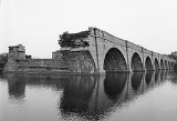
In Fort Hunter, the path of the canal was moved so that an aqueduct could be constructed across the Schoharie Creek. Construction began on the Schoharie Aqueduct in 1838 by Otis Eddy and was completed in 1841. Fourteen arches spanning 624 feet carried the Enlarged Erie Canal and towpath across the Schoharie Creek from 1845 until 1916.
In the 1940's, the Army Corps of Engineers demolished the easternmost six arches of the aqueduct to alleviate ice jams. A seventh arch collapsed during a 1977 flood, and an eight collapsed on August 16, 1998. Six arches remain standing today.
The aqueduct was named a National Historic Landmark
in 1960.,
The Schoharie Crossing State Historic Site includes many other remnants of the Enlarged Erie Canal.
The canal opened in 1917 and remains in use today.
In 1966, the state owned land at Fort Hunter, was transferred to the Office of Parks, Recreation, and Historic Preservation and Schoharie Crossing State Historic Site was formed.
Throughout the years, many changes, additions, and improvements have been made.
The Visitor Center is located at 129 Schoharie Street in Fort Hunter, New York. The building was built as a boarding house in the 1890's and was used as such until it opened as the Visitor Center in the 1980's. When the parking lot was put in, remains of a stone wall were uncovered. The remains are believed to be associated with the original Fort Hunter and Queen Anne's Chapel. "Little Short of Madness" is the name of the permanent exhibit at the site. It brings visitors through the progression of the canal system in New York. Restrooms and a gift shop are located here.
Yankee Hill Picnic area is located on Queen Anne Street by Lock 28 and Putman's Canal Store.
A boat launch and picnic area are located at the end Dufel Road on the West side of the Schoharie Creek.
Erie Canal
The Erie Canal is a waterway in New York that runs about from Albany, New York, on the Hudson River to Buffalo, New York, at Lake Erie, completing a navigable water route from the Atlantic Ocean to the Great Lakes. The canal contains 36 locks and encompasses a total elevation differential of...
aqueduct over Schoharie Creek
Schoharie Creek
Schoharie Creek in New York, USA flows north from the foot of Indian Head Mountain in the Catskill Mountains through the Schoharie Valley to the Mohawk River. It is twice impounded north of Prattsville to create New York City's Schoharie Reservoir and the Blenheim-Gilboa Power Project.Two notable...
, and a 3.5 miles (5.6 km) long part of the Erie Canal
Erie Canal
The Erie Canal is a waterway in New York that runs about from Albany, New York, on the Hudson River to Buffalo, New York, at Lake Erie, completing a navigable water route from the Atlantic Ocean to the Great Lakes. The canal contains 36 locks and encompasses a total elevation differential of...
, in the towns of Glen
Glen, New York
Glen is a town in Montgomery County, New York, United States. The population was 2,507 at the 2010 census. The town was named after Jacob S.Glen, an early landowner....
and Florida
Florida, New York
Florida is the name of some places in the U.S. state of New York:*Florida, Montgomery County, New York, a town*Florida, Orange County, New York, a village...
within Montgomery County, New York
Montgomery County, New York
As of the census of 2000, there were 49,708 people, 20,038 households, and 13,104 families residing in the county. The population density was 123 people per square mile . There were 22,522 housing units at an average density of 56 per square mile...
. It is the only part of the old canal that has been designated a National Historic Landmark
National Historic Landmark
A National Historic Landmark is a building, site, structure, object, or district, that is officially recognized by the United States government for its historical significance...
.
Schoharie Crossing State Historic Site is the only location where all three phases of New York's Canals can be seen at once. In addition to the Schoharie Aqueduct, the only two remaining locks of the original canal can be found at Schoharie Crossing, as well as three enlarged canal locks and one barge canal lock.
Tiononderoge and Fort Hunter
Located at the south east corner of the confluence of the Mohawk RiverMohawk River
The Mohawk River is a river in the U.S. state of New York. It is the largest tributary of the Hudson River. The Mohawk flows into the Hudson in the Capital District, a few miles north of the city of Albany. The river is named for the Mohawk Nation of the Iroquois Confederacy...
and Schoharie Creek
Schoharie Creek
Schoharie Creek in New York, USA flows north from the foot of Indian Head Mountain in the Catskill Mountains through the Schoharie Valley to the Mohawk River. It is twice impounded north of Prattsville to create New York City's Schoharie Reservoir and the Blenheim-Gilboa Power Project.Two notable...
was the Native American fortified village of Tiononderoge. The name is Mohawk
Mohawk language
Mohawk is an Iroquoian language spoken by around 2,000 people of the Mohawk nation in the United States and Canada . Mohawk has the largest number of speakers of the Northern Iroquoian languages; today it is the only one with greater than a thousand remaining...
meaning "the meeting of the waters." The Wolf clan of the Mohawk people settled here as early as 1692. Europeans called the village the Lower Castle. It was the major eastern settlement of the Mohawk.
In 1710, Peter Schuyler, mayor of Albany, invited three Mohawk chiefs and one Mahican
Mahican
The Mahican are an Eastern Algonquian Native American tribe, originally settling in the Hudson River Valley . After 1680, many moved to Stockbridge, Massachusetts. During the early 1820s and 1830s, most of the Mahican descendants migrated westward to northeastern Wisconsin...
chief (of the Algonquian-speaking peoples) to travel to England
England
England is a country that is part of the United Kingdom. It shares land borders with Scotland to the north and Wales to the west; the Irish Sea is to the north west, the Celtic Sea to the south west, with the North Sea to the east and the English Channel to the south separating it from continental...
and visit Queen Anne
Queen Anne
"Queen Anne" generally refers to Anne, Queen of Great Britain , Queen of England, Scotland and Ireland from 1702, and of Great Britain from 1707.Queen Anne may also refer to:-Uses relating to Queen Anne of Great Britain:...
to solidify their trading alliance. The Mohawk chiefs asked for help in defense against the French, including Anglican missionaries to offset French Catholic influence among their people. Numerous Catholic Mohawk had moved up to the St. Lawrence River valley, where they settled south of Montreal
Montreal
Montreal is a city in Canada. It is the largest city in the province of Quebec, the second-largest city in Canada and the seventh largest in North America...
at a village they named Kahnawake, after their former Caughnawaga in the Mohawk Valley.
Queen Anne asked the Mohawk for help in settling Palatine German refugees in New York, who had arrived that year and were working in English camps along the Hudson River. Hendrick Tejonihokarawa
Hendrick Tejonihokarawa
Hendrick Tejonihokarawa, also known as Tee Yee Neen Ho Ga Row and Hendrick Peters was a pro-English leader of the Mohawk who was one of the "Four Mohawk Kings" who went to London in 1710 to meet with Queen Anne...
offered Mohawk land near the Schoharie. Later it was offered to the Germans through Governor Hunter, and some settled in the Schoharie Valley.
As a result of the Mohawk request for aid, Queen Anne authorized Schuyler to build Fort Hunter, named after Colonial Govenor Robert Hunter; the complex was completed in 1712, located near where Schoharie Creek entered the Mohawk River. The fort was 150-foot square with a blockhouse at each corner. The main gate faced north. A wooden chapel was built at the center. The chapel was named after Queen Anne, who sent communion silver and other items to furnish it.
In 1741, Queen Anne's Chapel was rebuilt using limestone blocks that were quarried locally. By 1775, colonists estimated 600 "praying Indians" (Christians) lived at Fort Hunter.
Shortly thereafter, fighting broke out in the Mohawk Valley and across the colonies as part of the American Revolutionary War
American Revolutionary War
The American Revolutionary War , the American War of Independence, or simply the Revolutionary War, began as a war between the Kingdom of Great Britain and thirteen British colonies in North America, and ended in a global war between several European great powers.The war was the result of the...
. The Mohawks sided with England, as they had for the previous century in conflicts with the French. Fighting alongside the British at the Battle of Oriskany
Battle of Oriskany
The Battle of Oriskany, fought on August 6, 1777, was one of the bloodiest battles in the North American theater of the American Revolutionary War and a significant engagement of the Saratoga campaign...
and the Battle of Freeman's Farm, the Mohawk soon became disgusted with the British management of the conflicts and left to join their cousins, the Turtle clan, in the Saint Lawrence Valley.
In 1780, Mohawk warriors joined Sir John Johnson and Joseph Brant
Joseph Brant
Thayendanegea or Joseph Brant was a Mohawk military and political leader, based in present-day New York, who was closely associated with Great Britain during and after the American Revolution. He was perhaps the most well-known American Indian of his generation...
in fighting against the rebellious colonists in the Mohawk Valley. They participated in raids known as the "Burning of the Valleys." During one of the raids, a group of men retrieved Queen Anne's gifts, which had been buried at Fort Hunter. Today they are displayed at Brantford and Tyendinaga
Tyendinaga Mohawk Territory, Ontario
Tyendinaga Mohawk Territory is an 73 km² Mohawk First Nations reserve on the Bay of Quinte in southeastern Ontario, Canada, east of Belleville and immediately to the west of Deseronto...
, Ontario, Canada.
After the Revolutionary War, Queen Anne's Chapel was used for a time as a tavern and stable, to house the many migrants at Fort Hunter, which had developed into a village
Fort Hunter, New York
Fort Hunter is a hamlet in the town of Florida in Montgomery County, New York, on the Mohawk River at Schoharie Creek.In the 18th century, Fort Hunter was built as a fort near the location of one of the two primary Mohawk settlements. The Mohawk name for the village was rendered variously in...
. They were moving west along the valley into areas of New York state newly opened for European-American settlement since the Iroquois, as allies of the British were forced to cede their lands after the British defeat. The chapel was torn down during the construction of the Erie Canal
Erie Canal
The Erie Canal is a waterway in New York that runs about from Albany, New York, on the Hudson River to Buffalo, New York, at Lake Erie, completing a navigable water route from the Atlantic Ocean to the Great Lakes. The canal contains 36 locks and encompasses a total elevation differential of...
, completed in 1824.
The Original Erie Canal
The Erie CanalErie Canal
The Erie Canal is a waterway in New York that runs about from Albany, New York, on the Hudson River to Buffalo, New York, at Lake Erie, completing a navigable water route from the Atlantic Ocean to the Great Lakes. The canal contains 36 locks and encompasses a total elevation differential of...
was begun on July 4, 1817 in Rome, New York
Rome, New York
Rome is a city in Oneida County, New York, United States. It is located in north-central or "upstate" New York. The population was 44,797 at the 2010 census. It is in New York's 24th congressional district. In 1758, British forces began construction of Fort Stanwix at this strategic location, but...
. Six years later the section of the canal through Fort Hunter was completed.
The canal originally crossed the creek in a slack water pool that was created by a dam, which can be seen when the water is low, further down the creek. Boats would then be towed across while mules and horses were ferried. A towpath bridge was later built to help mules cross but the boats still had to make the dangerous crossing.
Schoharie Crossing State Historic Site is one of the only sites where the Original Erie Canal remains. It runs from the Schoharie Creek to the Enlarged Erie Canal Lock 29. Along the way are some significant features.
- A guard lock was constructed on the east side of the Schoharie Creek. The lock did not raise the level of the canal at all. It was built to protect the canal from the tumultuous waters of the creek. The Fort Hunter guard lock is the only guard lock that survives from the original canal. Folk lore states that the lock was built using the limestone blocks from Queen Anne's Chapel, which was razed to make way for the canal.
- Further down the canal, near the Enlarged Erie Canal Lock 29, is the Original Erie Canal Lock 20. Lock 20 is the only lift lock that survives from the original canal!
Both Lock 20 and the guard lock were filled with gravel in 1980 to stabilize them.
The Enlarged Erie Canal
Soon after the Original Erie Canal was completed, traffic outgrew it. By the 1830's, it was decided that the entire length would have to be enlarged to keep up with growing trade.In Fort Hunter, the path of the canal was moved so that an aqueduct could be constructed across the Schoharie Creek. Construction began on the Schoharie Aqueduct in 1838 by Otis Eddy and was completed in 1841. Fourteen arches spanning 624 feet carried the Enlarged Erie Canal and towpath across the Schoharie Creek from 1845 until 1916.
In the 1940's, the Army Corps of Engineers demolished the easternmost six arches of the aqueduct to alleviate ice jams. A seventh arch collapsed during a 1977 flood, and an eight collapsed on August 16, 1998. Six arches remain standing today.
The aqueduct was named a National Historic Landmark
National Historic Landmark
A National Historic Landmark is a building, site, structure, object, or district, that is officially recognized by the United States government for its historical significance...
in 1960.,
The Schoharie Crossing State Historic Site includes many other remnants of the Enlarged Erie Canal.
- "Yankee Hill" Lock 28 and Putman's Canal Store are located off of Queen Anne Street. The lock was built during the enlargement in the 1840's. Putman's was built in 1856 by the family of Garrett Putman and was used as a canal store through the early 1900's.
- "Empire" Lock 29 is located just east of East Church Street in Fort Hunter. It was constructed in the 1840's by James Ott and is one of the best preserved locks from the Enlarged Erie Canal.
- Lock 30 was built by James Stewart in the 1840's. In 1956, the lock was filled in and paved over to make way for Main Street.
The NYS Barge Canal
Traffic again outgrew the canal and it was decided at the beginning of the 20th century to abandon the Enlarged Erie Canal and construct a new "Barge" Canal. From Cohoes to Herkimer, the Mohawk River was canalized and many locks were added. Lock 12 was constructed at Fort Hunter.The canal opened in 1917 and remains in use today.
Schoharie Crossing State Historic Site
The Fort Hunter Canal Society was formed in the 1950's to preserve the ruins of the Erie Canal in Fort Hunter.In 1966, the state owned land at Fort Hunter, was transferred to the Office of Parks, Recreation, and Historic Preservation and Schoharie Crossing State Historic Site was formed.
Throughout the years, many changes, additions, and improvements have been made.
The Visitor Center is located at 129 Schoharie Street in Fort Hunter, New York. The building was built as a boarding house in the 1890's and was used as such until it opened as the Visitor Center in the 1980's. When the parking lot was put in, remains of a stone wall were uncovered. The remains are believed to be associated with the original Fort Hunter and Queen Anne's Chapel. "Little Short of Madness" is the name of the permanent exhibit at the site. It brings visitors through the progression of the canal system in New York. Restrooms and a gift shop are located here.
Yankee Hill Picnic area is located on Queen Anne Street by Lock 28 and Putman's Canal Store.
A boat launch and picnic area are located at the end Dufel Road on the West side of the Schoharie Creek.
External links
- Schoharie Crossing State Historic Site, at NYS Office of Parks, Recreation and Historic Preservation
- Schoharie Aqueduct (30 photos) and 3 drawings at Historic American Buildings SurveyHistoric American Buildings SurveyThe Historic American Buildings Survey , Historic American Engineering Record , and Historic American Landscapes Survey are programs of the National Park Service established for the purpose of documenting historic places. Records consists of measured drawings, archival photographs, and written...
- Yankee Hill Lock Number 28, Schoharie Creek Aqueduct Vicinity (4 photos), at HABS.
- Erie Canal: Schoharie Crossing State Historic Park, with photos
- More park information from Wildernet