
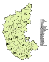
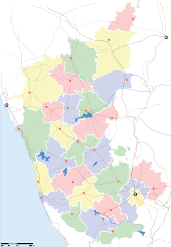
Districts of Karnataka
Encyclopedia
States and territories of India
India is a federal union of states comprising twenty-eight states and seven union territories. The states and territories are further subdivided into districts and so on.-List of states and territories:...
of Karnataka
Karnataka
Karnataka , the land of the Kannadigas, is a state in South West India. It was created on 1 November 1956, with the passing of the States Reorganisation Act and this day is annually celebrated as Karnataka Rajyotsava...
is located within 11°30' North and 18°30' North latitudes and 74° East and 78°30' East longitude. It is situated on a tableland where the Western
Western Ghats
The Western Ghats, Western Ghauts or the Sahyādri is a mountain range along the western side of India. It runs north to south along the western edge of the Deccan Plateau, and separates the plateau from a narrow coastal plain along the Arabian Sea. The Western Ghats block rainfall to the Deccan...
and Eastern Ghat
Eastern Ghats
The Eastern Ghats or Eastern Ghauts are a discontinuous range of mountains along India's eastern coast. The Eastern Ghats run from West Bengal state in the north, through Orissa and Andhra Pradesh to Tamil Nadu in the south passing some parts of Karnataka. They are eroded and cut through by the...
ranges converge into the Nilgiri hill
Nilgiris (mountains)
The Nilgiri , often referred to as the Nilgiri Hills, are a range of mountains with at least 24 peaks above , in the westernmost part of Tamil Nadu state at the junction of Karnataka and Kerala states in Southern India...
complex, in the western part of the Deccan Peninsular region of India. The State is bounded by Maharastra and Goa
Goa
Goa , a former Portuguese colony, is India's smallest state by area and the fourth smallest by population. Located in South West India in the region known as the Konkan, it is bounded by the state of Maharashtra to the north, and by Karnataka to the east and south, while the Arabian Sea forms its...
States in the north and northwest; the Arabian Sea
Arabian Sea
The Arabian Sea is a region of the Indian Ocean bounded on the east by India, on the north by Pakistan and Iran, on the west by the Arabian Peninsula, on the south, approximately, by a line between Cape Guardafui in northeastern Somalia and Kanyakumari in India...
in the west; Kerala
Kerala
or Keralam is an Indian state located on the Malabar coast of south-west India. It was created on 1 November 1956 by the States Reorganisation Act by combining various Malayalam speaking regions....
and Tamil Nadu
Tamil Nadu
Tamil Nadu is one of the 28 states of India. Its capital and largest city is Chennai. Tamil Nadu lies in the southernmost part of the Indian Peninsula and is bordered by the union territory of Pondicherry, and the states of Kerala, Karnataka, and Andhra Pradesh...
States in the south and the State of Andhra Pradesh
Andhra Pradesh
Andhra Pradesh , is one of the 28 states of India, situated on the southeastern coast of India. It is India's fourth largest state by area and fifth largest by population. Its capital and largest city by population is Hyderabad.The total GDP of Andhra Pradesh is $100 billion and is ranked third...
in the east. The state covers an area of 191,976 square kilometres (74,122 sq mi), or 5.83% of the total geographical area of India. Geographically, the state is divided into 3 principal regions:the coastal region of Karavali, the hilly Malenadu region comprising the Western Ghats
Western Ghats
The Western Ghats, Western Ghauts or the Sahyādri is a mountain range along the western side of India. It runs north to south along the western edge of the Deccan Plateau, and separates the plateau from a narrow coastal plain along the Arabian Sea. The Western Ghats block rainfall to the Deccan...
and the Bayaluseeme region comprising the plains of the Deccan plateau
Deccan Plateau
The Deccan Plateau is a large plateau in India, making up the majority of the southern part of the country. It rises a hundred meters high in the north, rising further to more than a kilometers high in the south, forming a raised triangle nested within the familiar downward-pointing triangle of...
.
After Indian independence, Maharaja Jayachamarajendra Wodeyar acceded the princely state of Mysore
Kingdom of Mysore
The Kingdom of Mysore was a kingdom of southern India, traditionally believed to have been founded in 1399 in the vicinity of the modern city of Mysore. The kingdom, which was ruled by the Wodeyar family, initially served as a vassal state of the Vijayanagara Empire...
to India. In 1950, Mysore
Mysore State
The Kingdom of Mysore was one of the three largest princely states within the erstwhile British Empire of India. Upon India gaining its independence in 1947, the Maharaja of Mysore merged his realm with the Union of India...
became an Indian state. Following the long-standing demand of the Ekikarana Movement
Unification of Karnataka
The Unification of Karnataka refers to the formation of the Indian state of Karnataka, then called as Mysore State, in 1956 when several Indian states were created by redrawing borders based on linguistic demographics...
, Kodagu- and Kannada-speaking regions from the adjoining states of Madras, Hyderabad and Bombay were incorporated into the Mysore state, under the States Reorganization Act of 1956. The thus expanded state was renamed Karnataka, seventeen years later, in 1973.
Karnataka is now divided into 30 districts and 4 administrative divisions. Districts are administered by a District collector
District collector
The District Collector is the district head of administration of the bureaucracy in a state of India. Though he/she is appointed and is under general supervision of the state government, he/she has to be a member of the elite IAS recruited by the Central Government...
, and divisions are administered by a Divisional Commissioner. Bangalore
Bangalore
Bengaluru , formerly called Bengaluru is the capital of the Indian state of Karnataka. Bangalore is nicknamed the Garden City and was once called a pensioner's paradise. Located on the Deccan Plateau in the south-eastern part of Karnataka, Bangalore is India's third most populous city and...
is the capital of the state.
History
Karnataka took its present shape in 1956, when the states of MysoreMysore State
The Kingdom of Mysore was one of the three largest princely states within the erstwhile British Empire of India. Upon India gaining its independence in 1947, the Maharaja of Mysore merged his realm with the Union of India...
and Coorg (Kodagu) were merged with the Kannada-speaking districts of the former states of Bombay
Bombay State
The Bombay State was a state of India, dissolved with the formation of Maharashtra and Gujarat states on May 1, 1960.-History:During British rule, portions of the western coast of India under direct British rule were part of the Bombay Presidency...
, Hyderabad
Hyderabad State
-After Indian independence :When India gained independence in 1947 and Pakistan came into existence in 1947, the British left the local rulers of the princely states the choice of whether to join one of the new dominions or to remain independent...
, and Madras
Madras State
Madras State was the name by which the Indian districts in Tamil Nadu, Andhra, Northern Kerala, Bellary and Dakshina Kannada were collectively known as from 1950 to 1953....
. Mysore state was made up of ten districts, Bangalore, Kolar, Tumkur, Mandya, Mysore, Hassan, Chikmagalur (Kadur), Shimoga and Chitradurga; Bellary
Bellary
Bellary is a historic city in Bellary District in Karnataka state, India.-Origins of the city's name:There are several legends about how Bellary got its name....
had been transferred from Madras state to Mysore in 1953, when the new state of Andhra Pradesh
Andhra Pradesh
Andhra Pradesh , is one of the 28 states of India, situated on the southeastern coast of India. It is India's fourth largest state by area and fifth largest by population. Its capital and largest city by population is Hyderabad.The total GDP of Andhra Pradesh is $100 billion and is ranked third...
was created out of Madras' northern districts. Coorg state became a district, Dakshina Kannada
Dakshina Kannada
- Geography :The district geography consists of sea shore in the west and Western Ghats in the east. The major rivers are Netravathi, Kumaradhara, Phalguni, Shambhavi, Nandini or Pavanje and Payaswini which all join Arabian sea. Vast areas of evergreen forests which once covered this district, have...
(South Kanara) district was transferred from Madras State, North Kanara, Dharwad District
Dharwad District
Dharwad District is an administrative district of the state of Karnataka in southern India. Dharwad is the cultural headquarters of North Karnataka....
, Belgaum District
Belgaum district
Belgaum district is a district in the state of Karnataka, India. The city of Belgaum is the district headquarters in North Karnataka. By the 2011 Census of India, it had a population of 4778439...
, and Bijapur District from Bombay State, and Bidar
Bidar
Bidar is a city in the Indian state of Karnataka. Located on the Deccan Plateau in the north-eastern part of Karnataka. It is the headquarters of the Bidar District....
, Gulbarga District
Gulbarga District
Gulbarga district is one of the 30 districts of Karnataka state in southern India. Gulbarga city is the administrative headquarters of the district...
, and Raichur district
Raichur district
Raichur District is an administrative district in the Indian state of Karnataka. It is located in the northeast part of the state and is bounded by Yadgir district in the north, Bijapur and Bagalkot district in the northwest, Koppal district in the west, Bellary district in the south, Anantapur...
from Hyderabad State.
In 1989, the Bangalore Rural district was split from Bangalore. In 1997 Bagalkot district was split from Bijapur, Chamrajnagar district was split from Mysore, Gadag district was split from Dharwad, Haveri district was split from Dharwad, Koppal district was split from Raichur, Udupi district was split from Dakshina Kannada, and Davanagere district was created from parts of Chitradurga, Shimoga and Bellary.
On June 21, 2007 the Government
Government of Karnataka
The Government of Karnataka is a democratically elected body with the Governor as the constitutional head. The Governor who is appointed for a period of five years appoints the Chief Minister and his council of ministers...
announced the cabinet approval for the creation of two more districts: Ramanagara District
Ramanagara district
Ramanagara district is one of the 30 districts of Karnataka state in southern India. Ramanagara city is the administrative headquarters of this district...
and Chikballapur district. Ramanagara District and Chikballapura District are being formed by the bifurcation of Bangalore Rural District
Bangalore Rural district
Bangalore Rural District is one of the 30 districts in Karnataka. It was formed in 1986, when Bangalore district was divided into Bangalore Rural and Bangalore . Presently in Bangalore Rural district, there are 2 divisions, 4 Talukas, 35 Hoblis , 1,713 inhabited and 177 uninhabited villages, 9...
and Kolar District
Kolar district
Kolar district is a district in Karnataka state of India. The town of Kolar is the district headquarters. Kolar district is located in the southern region of the State and is the eastern-most district of the Karnataka State...
s respectively.
On December 30, 2009, Yadgir district
Yadgir district
Yadgir district is one of the 30 districts of Karnataka state in southern India. This district was carved out from the erstwhile Gulbarga district as the 30th district of Karnataka on 10 April 2010. Yadgir town is the administrative headquarters of the district...
was carved out of Gulbarga district
Gulbarga District
Gulbarga district is one of the 30 districts of Karnataka state in southern India. Gulbarga city is the administrative headquarters of the district...
and officially declared the 30th district of Karnataka.
Administrative Structure
A district of an Indian state is an administrative geographical unit, headed by a Deputy CommissionerDeputy Commissioner (India)
The deputy commissioner or district magistrate or district collector or district magistrate and collector is the head of the revenue administration of an Indian district. The DC is required to be an Indian Administrative Service officer who is in charge of governmental assets in his district of...
or District Magistrate, an officer belonging to the Indian Administrative Service
Indian Administrative Service
The Indian Administrative Service is the administrative civil service of the Government of India. It is one of the three All India Services....
. The district magistrate or the deputy commissioner is assisted by a number of officers belonging to the Karnataka Civil Service and other Karnataka state services.
A Superintendent of Police (India), usually an officer belonging to the Indian Police Service
Indian Police Service
The Indian Police Service , simply known as Indian Police or IPS, is one of the three All India Services of the Government of India...
is entrusted with the responsibility of maintaining law and order and related issues of the district. He is assisted by the officers of the Karnataka Police Service and other Karnataka Police officials. Cities like Bangalore
Bangalore
Bengaluru , formerly called Bengaluru is the capital of the Indian state of Karnataka. Bangalore is nicknamed the Garden City and was once called a pensioner's paradise. Located on the Deccan Plateau in the south-eastern part of Karnataka, Bangalore is India's third most populous city and...
, Mysore and Hubli-Dharwad are headed by a Commissioner of Police holding the rank of Additional Director General of Police(ADGP) or Inspector General of Police (IGP).
A Deputy Conservator of Forests
Deputy Conservator of Forests (India)
A Deputy Conservator of Forests or, equivalently a Divisional Forest Officer is an officer belonging to the elite Indian Forest Service. The Deputy Conservator of Forests is responsible for managing the Forests, Environment and Wild-Life related issues of a Forest Division of a state or a union...
, an officer belonging to the Indian Forest Service
Indian Forest Service
The Indian Forest Service is the Forestry service of India. It is one of the three All India Services of the Indian government, along with the Indian Administrative Service and Indian Police Service; its employees are recruited by the national government but serve under the state governments or...
is responsible for managing the forests, the environment and wild-life of the district. He is assisted by the officers of the Karnataka Forest Service and other Karnataka Forest officials and Karnataka wildlife officials.
Sectoral development is looked after by the district head of each development department such as PWD, Health, Education, Agriculture, Animal husbandry, etc. These officers belong to the various state services.
| Bangalore Division Bangalore Division Bangalore division is one of the four divisions of Karnataka state of India. The division comprises the districts of Bangalore, Bangalore Rural, Chitradurga, Davanagere, Kolar, Shimoga, and Tumkur.-See also:*Districts of Karnataka... |
Belgaum Division Belgaum Division Belgaum Division is one of the four divisions of Karnataka state of India. The division comprises the districts of Bagalkot, Belgaum, Bijapur, Dharwad, Gadag, Haveri, and Uttara Kannada. Totally it covers a geographical area of and has a population of 13,042,163 as of the 2001 census. The... |
Gulbarga Division Gulbarga Division Gulbarga division is one of the four divisions of karnataka state of India. The division comprises the districts of Bellary, Bidar, Gulbarga, Koppal, and Raichur. The city of Gulbarga serves as the administrative headquarters of the division.... |
Mysore Division Mysore Division Mysore Division includes the districts of Mysore, Chamarajanagar, Mandya, Dakshina Kannada, Udupi, Kodagu, Chikmagalur and Hassan. The administrative headquarters of the division is Mysore. This division is home to :... |
|---|---|---|---|
|
Bagalkot district Bāgalkot district is an administrative district in the Indian state of Karnataka. The district headquarters is located in the town of Bagalkot. The district is located in northern Karnataka and borders Belgaum, Gadag, Koppal, Raichur and Bijapur... Belgaum district Belgaum district is a district in the state of Karnataka, India. The city of Belgaum is the district headquarters in North Karnataka. By the 2011 Census of India, it had a population of 4778439... Dharwad District Dharwad District is an administrative district of the state of Karnataka in southern India. Dharwad is the cultural headquarters of North Karnataka.... Gadag District Gadag District had a population of 971,952 of which 35.21% was urban as of 2001. Population increased 13.14% in the decade 1991-2001. The District is bounded on the north by Bagalkot District, on the east by Koppal District, on the southeast by Bellary District, on the southwest by Haveri... Haveri District Haveri is a district in the state of Karnataka, India with the potential to become a tourist hub. As of 2001, it had a population of 1,439,116 of which 20.78% were urban residents.-Tourism:Examples of tourist attractions in the district:... |
Bidar District Bidar is a district of Karnataka state in southern India. The historic city of Bidar is the administrative centre of the district. The district is located in the northeastern corner of the state, near the borders with Andhra Pradesh to the east and Maharashtra to the north and west... Gulbarga District Gulbarga district is one of the 30 districts of Karnataka state in southern India. Gulbarga city is the administrative headquarters of the district... Koppal district Koppal district is an administrative district in the state of Karnataka in India. In the past Koppal was referred to as 'Kopana Nagara'. Hampi, a World heritage center, covers some areas of Koppal District. It is situated approximately 38 km away... Raichur district Raichur District is an administrative district in the Indian state of Karnataka. It is located in the northeast part of the state and is bounded by Yadgir district in the north, Bijapur and Bagalkot district in the northwest, Koppal district in the west, Bellary district in the south, Anantapur... Yadgir district Yadgir district is one of the 30 districts of Karnataka state in southern India. This district was carved out from the erstwhile Gulbarga district as the 30th district of Karnataka on 10 April 2010. Yadgir town is the administrative headquarters of the district... |
Chamarajanagar district Chamarajanagara is the southern-most district in the state of Karnataka, India. It was carved out of the original larger Mysore District in the year 1998... Chikmagalur District Chikkamagaluru is a district in the Indian state of Karnataka. Chikkamagaluru is where coffee was first cultivated in India. The mountains here which are a part of the Western Ghats are the source of rivers like Tunga and Bhadra. Chikkamagaluru district also contains Mullayanagiri; which is the... Hassan district Hassan is a district in Karnataka state, India. The district headquarters are Hassan.Hassan district was the seat of the Hoysala Empire which at its peak ruled large parts of south India from Belur as its early capital and Halebidu as its later capital during the period 1000 - 1334 CE... Mysore district Mysore District is an administrative district located in the southern part of the state of Karnataka, India. The district is bounded by Mandya district to the northeast, Chamrajanagar district to the southeast, Kerala state to the south, Kodagu district to the west, and Hassan district to the north... Udupi district Udupi district , ಉಡುಪಿ ಜಿಲ್ಲೆ) in the Karnataka state of India was created in August 1997. The three northern taluks, Udupi, Kundapur and Karkal, were separated from Dakshina Kannada District to form Udupi district. Udupi district is surrounded by Uttara Kannada district in north, Dakshina Kannada... |
Alphabetical listing
| Code | District | Headquarters | Established | Subdivisions | Population | Area | Population density Population density Population density is a measurement of population per unit area or unit volume. It is frequently applied to living organisms, and particularly to humans... |
Map |
| BK | Bagalkot Bagalkot district Bāgalkot district is an administrative district in the Indian state of Karnataka. The district headquarters is located in the town of Bagalkot. The district is located in northern Karnataka and borders Belgaum, Gadag, Koppal, Raichur and Bijapur... |
Bagalkot Bagalkot Bagalkot or Bagalkote is a town in the Indian state of Karnataka. Bagalkot is the district headquarters of the Bagalkot district. It is one of the major towns in North Karnataka.-History:... |
15 August 1997 |
|
1,651,892 | 6575 sqkm | 251 /sqkm | |
| BN | Bangalore Urban | Bangalore Bangalore Bengaluru , formerly called Bengaluru is the capital of the Indian state of Karnataka. Bangalore is nicknamed the Garden City and was once called a pensioner's paradise. Located on the Deccan Plateau in the south-eastern part of Karnataka, Bangalore is India's third most populous city and... |
1 November 1956 |
Anekal Anekal is a taluk of Bangalore district. It lies in the southern part of the Bangalore metropolitan area around 40 kilometres from downtown Bangalore.Kannada is the most widely spoken languages in Anekal.Anekal is known for the karaga festivals... |
6,537,124 | 2208 sqkm | 2985 /sqkm | |
| BR | Bangalore Rural Bangalore Rural district Bangalore Rural District is one of the 30 districts in Karnataka. It was formed in 1986, when Bangalore district was divided into Bangalore Rural and Bangalore . Presently in Bangalore Rural district, there are 2 divisions, 4 Talukas, 35 Hoblis , 1,713 inhabited and 177 uninhabited villages, 9... |
Bangalore Bangalore Bengaluru , formerly called Bengaluru is the capital of the Indian state of Karnataka. Bangalore is nicknamed the Garden City and was once called a pensioner's paradise. Located on the Deccan Plateau in the south-eastern part of Karnataka, Bangalore is India's third most populous city and... |
15 August 1986 |
Devanahalli Devanahalli previously called Devanadoddi, Devanapura, and Yusufabad) is a city in the state of Karnataka in India. The city is located outside the city limits of Bangalore. Devanahalli is the site of the newly constructed Bengaluru International Airport, the second largest in India... Hoskote Hoskote Hoskote is a taluk in Bangalore Rural District. Headquartered at the Hoskote town, it consists of 5 Hoblis - Anugondanahalli, Jadigenahalli, Kasaba, Nandagudi and Sulibele... Nelamangala Nelamangala is a town and taluk headquarters in the Bangalore Rural district of Karnataka state in India. Nelamangala lies near the junction of two National Highways, NH-48 and NH-4 .- Geography :... |
850,968 | 2259 sqkm | 377 /sqkm | |
| BG | Belgaum Belgaum district Belgaum district is a district in the state of Karnataka, India. The city of Belgaum is the district headquarters in North Karnataka. By the 2011 Census of India, it had a population of 4778439... |
Belgaum Belgaum Belgaum is a city and a municipal corporation in Belgaum district in the state of Karnataka, India. It is the fourth largest city of the state of Karnataka, the first three being Bangalore, Mysore, Hubli-Dharwad.... |
1 November 1956 |
Belgaum Belgaum is a city and a municipal corporation in Belgaum district in the state of Karnataka, India. It is the fourth largest city of the state of Karnataka, the first three being Bangalore, Mysore, Hubli-Dharwad.... Chikodi - Geography :Chikodi is located at . It has an average elevation of 683 metres . It is an Educational District.- Demographics : India census, Chikodi had a population of 32,820. Males constitute 51% of the population and females 49%... Gokak Gokak is a town and taluk headquarters in the Belgaum District of Karnataka state, India. It is located around 70 km from Belgaum at the confluence of two rivers, the Ghataprabha and the Markandeya. The population of the city is approximately 1,50,000 and the common language in use is Kannada... Khanapur Khanapur is a Town Council in Belgaum district in the Indian state of Karnataka. It is about 26 km from Belgaum. The town is governed by the Khanapur Municipal Council. Khanapur taluka falls under Belgaum District. The town is on the Belgaum - Panaji National Highway 4A... Raybag Raybag is a panchayat town in Belgaum district in the Indian state of Karnataka.-Geography:Raybag is located at . It has an average elevation of 590 metres .-Demographics:... Ramdurg Ramdurg is a town in Belgaum district in the Indian state of Karnataka.It is believed that Rama stayed in this place during his exile, hence the name.-History:... Saundatti Savadatti is one of the oldest towns in Belgaum district in the south Indian state of Karnataka. It is a celebrated pilgrimage centre located 78 kilometres from Belgaum. Savadatti is also the name of the taluk , which was previously named Parasgad. There are several ancient temples in... |
4,214,505 | 13415 sqkm | 314 /sqkm | |
| BL | Bellary | Bellary Bellary Bellary is a historic city in Bellary District in Karnataka state, India.-Origins of the city's name:There are several legends about how Bellary got its name.... |
1 November 1956 |
Bellary Bellary is a historic city in Bellary District in Karnataka state, India.-Origins of the city's name:There are several legends about how Bellary got its name.... Hospet Hospet , is a city in Bellary District in northern Karnataka, India. It is on the Tungabhadra River, 12 km from the World Heritage site consisting of the ruins of the medieval city of Vijayanagara, former capital of the Vijayanagara Empire.... Kampli Kampli is a town in the Bellary district, Hospet taluk, in the Indian state of Karnataka. The town is situated about 15 km away from world famous Hampi.- Administration :Kampli is administered by town municipality... Hoovina Hadagalli Huvina Hadagali is a panchayat town in Bellary district in the Indian state of Karnataka.-Historical Names of Huvina Hadagali:*Puvina-Posavadangile* Puvina-Padangile-Demographics:... Kudligi Kudligi is a panchayat town in Bellary district in the India state of Karnataka.-Geography:Kudligi is located at . It has an average elevation of 596 metres . The oldest temple, Shri Hulikunteraya Temple, Bommaghatta , is 23 km away.-Demographics: India census, Kudligi had a population of... Siruguppa Siruguppa is a panchayat town in Bellary district in the Indian state of Karnataka.-Geography:Siruguppa is located at . It has an average elevation of 373 metres .-Demographics:... |
2,027,140 | 8450 sqkm | 240 /sqkm | |
| BD | Bidar Bidar District Bidar is a district of Karnataka state in southern India. The historic city of Bidar is the administrative centre of the district. The district is located in the northeastern corner of the state, near the borders with Andhra Pradesh to the east and Maharashtra to the north and west... |
Bidar Bidar Bidar is a city in the Indian state of Karnataka. Located on the Deccan Plateau in the north-eastern part of Karnataka. It is the headquarters of the Bidar District.... |
1 November 1956 |
Bidar Bidar is a city in the Indian state of Karnataka. Located on the Deccan Plateau in the north-eastern part of Karnataka. It is the headquarters of the Bidar District.... Basavakalyan Basavakalyan is a town in Bidar District of the state of Karnataka, India, and was historically known as Kalyan.-History:Basavakalyan's history dates back to 3000 years with its name being mentioned in Guru Charitra.... Bhalki Bhalki is a town, and a taluka, in Bidar district in the state of Karnataka, India.-History:First mention of the town was made as "Bhallunke" in the vachanas of 12th century sharanas... Homnabad Humnabad is a town in Bidar district in the Indian state of Karnataka. The town is also the headquarters of Humnabad Taluk. Humnabad is connected by two national highways NH 9 and NH 218.... Aurad Aurad is a panchayat town in Bidar district in the state of Karnataka, India.- History :Aurad has a famous Amareshwar temple located in the heart of town. The temple was built in 10th Century... |
1,502,373 | 5448 sqkm | 276 /sqkm | |
| BJ | Bijapur | Bijapur Bijapur, Karnataka Bijapur Urdu:بیجاپور city is the district headquarters of Bijapur District of Karnataka state. Bijapur city is well known for its historical monuments of architectural importance built during the rule of Adil Shahi dynasty... |
1 November 1956 |
Bijapur, Karnataka Bijapur Urdu:بیجاپور city is the district headquarters of Bijapur District of Karnataka state. Bijapur city is well known for its historical monuments of architectural importance built during the rule of Adil Shahi dynasty... Indi, Karnataka Indi is a town in the state of Karnataka, India. It is the taluk headquarters of Indi Taluk, in the district of Bijapur.-Geography:Indi is located at . It has an average elevation of 465 meters . It is located at the border of Maharashtra, a neighboring state of Karnataka. The soil at Indi is... Muddebihal Muddebihal is a town in Bijapur district in the Indian state of Karnataka.-Geography:Muddebihal is located at . It has an average elevation of 563 metres .-Demographics:... Sindgi Sindagi or Sindgi is a town in Bijapur district, about 60 km to the east of Bijapur. It is in the Indian state of Karnataka.-Geography:Sindagi is located at . It has an average elevation of 500 metres .-Demographics:... Basavana Bagevadi Basavana Bagevadi is a panchayat town in Bijapur district in the state of Karnataka, India.-Demographics: India census, Basavana Bagevadi had a population of 28,582. Males constitute 51% of the population and females 49%. Basavana Bagevadi has an average literacy rate of 53%, lower than the... |
1,806,918 | 10494 sqkm | 171 /sqkm | |
| CJ | Chamarajanagar Chamarajanagar district Chamarajanagara is the southern-most district in the state of Karnataka, India. It was carved out of the original larger Mysore District in the year 1998... |
Chamarajanagar Chamarajanagar Chamarajanagar is a town in the southern end of Karnataka, a state in India. It is also the headquarters of the Chamarajanagar district of Karnataka. It is named after Chamaraja Wodeyar IX , king of Mysore, who was born in the town... |
15 August 1997 |
Gundlupet Gundlupet is a town in Chamarajanagar district in the Indian state of Karnataka. This small town is about 56 km from the Mysore-Ooty / Mysore-Calicut road and about 200 km from Bangalore. Gundlupet is the last town in Karnataka en route to Ooty or Kozhikode.The Bandipur National Park... Kollegal Kollegal is one of the major taluks in the Chamrajnagar District of Karnataka State in the south of India. Kollegal is well known for its silk industry which attracts traders from all over the state.-History:... Yelandur Yalandur is a small taluka town in Chamarajanagar district in the Indian state of Karnataka.It has historic and cultural importance in this region- Geography :Yelandur is located at . It has an average elevation of 555 metres .... |
965,462 | 5101 sqkm | 189 /sqkm | |
| Chikballapur | Chikballapur Chikballapur Chikkaballapur is the District Headquarters of the newly created Chikkaballapur district in the state of Karnataka, India. Located within 3 km of Muddenahalli and its nearby town, Kanivenarayanapura, the sites of the upcoming Sri Sathya Sai Baba University and College of Medicine, Indian... |
10 September 2007 |
Bagepalli Bagepalli Kannada:ಬಾಗೆಪಲ್ಲಿ is a panchayat town in Chikballapur district in the state of Karnataka, India. Bagepalli is situated 100 km north of Bangalore on the Bangalore-Hyderabad National Highway. The region is just below the southern border of the Rayalaseema in Andhra Pradesh, South... Chikballapur Chikkaballapur is the District Headquarters of the newly created Chikkaballapur district in the state of Karnataka, India. Located within 3 km of Muddenahalli and its nearby town, Kanivenarayanapura, the sites of the upcoming Sri Sathya Sai Baba University and College of Medicine, Indian... Gauribidanur Gauribidanur is a historical town in Kolar district; now a part of Chikballapur district in the state of Karnataka, India. It is about 75 km from Bangalore, and 25 km from the Educational Hub of Muddenahalli-Kanivenarayanapura. kannada is spoken widely as primary luanguage... Gudibanda Gudibanda is a panchayat town in Chikkaballapur district in the Indian state of Karnataka.- Geography :Gudibanda is located at . It has an average elevation of 826 metres .- Demographics :... Sidlaghatta Sidlaghatta is a town in Chikkaballapur district in the Indian state of Karnataka.-Geography:Sidlaghatta is located at . It has an average elevation of 878 metres .It is the Silk City of state Karnataka.-Demographics:... |
1,149,007 | 4524 sqkm | 308 /sqkm | ||
| CK | Chikmagalur Chikmagalur District Chikkamagaluru is a district in the Indian state of Karnataka. Chikkamagaluru is where coffee was first cultivated in India. The mountains here which are a part of the Western Ghats are the source of rivers like Tunga and Bhadra. Chikkamagaluru district also contains Mullayanagiri; which is the... |
Chikmagalur | 1 November 1956 |
Kadur Kadur is a taluk in Chikmagalur district, in the Indian state of Karnataka. It was formerly, a district in the Mysore state, with an area of 2813sq. m. Pop. , 362,752, showing an increase of 9% in the decade.-Geography:Kadur is located at... Koppa, India Koppa is a panchayat town in Chikmagalur district in the Indian state of Karnataka. The town is famous for coffee and Tea estates. Arabica and Robusta varieties of coffee are grown here.. Koppa encovers 22 Gram Panchayats, one Town Panchayat and 3 Hobilis. Megunda Hobili is famous for Coffee. A no... Mudigere Mudigere is a panchayat town in Chikmagalur district in the Indian state of Karnataka. It is 35 km from the district headquarters. Several pilgrimage sites such as Dharmasthala , Horanadu, Kalasa, Sringeri are near to the town... Narasimharajapura Narasimharajapura is a panchayat town in Chikmagalur district in the Indian state of Karnataka.-Geography:Narasimharajapura is located at . It has an average elevation of 643 metres... Tarikere Tarikere is a taluk in Chikmagalur district in the state of Karnataka of India. The headquarters of Tarikere taluk is a town of the same name. The town has derived its name from number of water tanks by which the town is surrounded namely, Chikkere, Doddakere, Dalavikere,... |
1,140,905 | 7201 sqkm | 158 /sqkm | |
| CT | Chitradurga Chitradurga district Chitradurga district is an administrative district of Karnataka state in southern India. The city of Chitradurga is the district headquarters. Chitradurga gets its name from Chitrakaldurga, an umbrella-shaped lofty hill found there. Tradition dates Chitradurga District to the period of the... |
Chitradurga Chitradurga Chitradurga is a town in the southern part of the Indian state of Karnataka. It is also the headquarters of Chitradurga district. Chitradurga was also known by the names Chitradurg, Chitrakaladurga, Chittaldurg. Chittaldrug was the name officially used by the British Govt.-Geography:Chitradurga is... |
1 November 1956 |
Challakere -Geography:Challakere is located at . It has an average elevation of 585 metres .-Demographics: India census, Challakere had a population of 49,065. Males constitute 51% of the population and females 49%. Challakere has an average literacy rate of 69%, higher than the national average of... Chitradurga Chitradurga is a town in the southern part of the Indian state of Karnataka. It is also the headquarters of Chitradurga district. Chitradurga was also known by the names Chitradurg, Chitrakaladurga, Chittaldurg. Chittaldrug was the name officially used by the British Govt.-Geography:Chitradurga is... Hiriyur Hiriyur is a town and taluk capital located near Chitradurga in the Indian state of Karnataka.Hiriyur is renowned for having the oldest dam in Karnataka, built on the Vedavati river, and named Mari Kanive. The Water on the dam looks exactly the preindipendce India Map. Hiryur is situated along... Holalkere Holalkere is a town and taluk headquarters located near Chitradurga in the Indian state of Karnataka.-History:LegendsA Ganesha Temple with an idol of Lord Ganesha carved out of monolithic stone is around 20 ft tall, with entwined hairs and was established in 1475 CE. by the Nayaka Guthyappa... Hosadurga Hosdurga is a panchayat town in Chitradurga district in the Indian state of Karnataka.-Geography:Hosdurga is located at . It has an average elevation of 739 metres .-Demographics:... Molakalmuru Molakalmuru is a panchayat town in Chitradurga district in the Indian state of Karnataka. It is near the border of Karnataka state with Andhra Pradesh. It borders the Rayadurg Taluk of Ananthpur district of Andhra Pradesh. Molakalmuru has major villages like Rampura, Hangal... |
1,517,896 | 8440 sqkm | 180 /sqkm | |
| DK | Dakshina Kannada | Mangalore Mangalore Mangalore is the chief port city of the Indian state of Karnataka. It is located about west of the state capital, Bangalore. Mangalore lies between the Arabian Sea and the Western Ghat mountain ranges, and is the administrative headquarters of the Dakshina Kannada district in south western... |
1 November 1956 |
Bantwal Bantwal is a taluk in Dakshina Kannada district, Karnataka, India. It is also a town by the same name. The adjacent township of B.C.Road serves as the commercial center.- History :... Mangalore Mangalore is the chief port city of the Indian state of Karnataka. It is located about west of the state capital, Bangalore. Mangalore lies between the Arabian Sea and the Western Ghat mountain ranges, and is the administrative headquarters of the Dakshina Kannada district in south western... |
1,897,730 | 4560 sqkm | 416 /sqkm | |
| DA | Davanagere Davanagere district Davanagere District , also known as Devangere District, is an administrative district of Karnataka state in southern India. The city of Davanagere is the district headquarters. It had a population of 1,790,952 of which 30.32% was urban as of 2001.This district was carved out of Chitradurga district... |
Davanagere Davanagere Davangere or Davanagere is a city in the Indian state of Karnataka. It is the administrative headquarters of Davangere district which lies at the centre of the state of Karnataka. The city is located on National Highway 4 at a distance of about 265 km from the state capital, Bangalore... |
15 August 1997 |
Channagiri Channagiri is a panchayat town in Davanagere district in the state of Karnataka, India. It is a taluk headquarters in Davanagere District.-History:... Davanagere Davangere or Davanagere is a city in the Indian state of Karnataka. It is the administrative headquarters of Davangere district which lies at the centre of the state of Karnataka. The city is located on National Highway 4 at a distance of about 265 km from the state capital, Bangalore... Harihar Harihar is a city located in Davanagere District in the Indian state of Karnataka. Harihar also spelled Hari-hara, in Hinduism, a syncretic deity, combining the two major gods, Vishnu and Siva... Harpanahalli Harpanahalli is a town in Davanagere district in the Indian state of Karnataka.-Geography:Harpanahalli is located at . It has an average elevation of 633 metres . Harapanahalli is the biggest town in this district next to Davangere... Honnali Honnāli is a panchayat town in Davanagere district in the Indian state of Karnataka. Shimoga is around 44 km to the south, Ranebennur is around 46 km to the north, Harihar is around 40 km to the north east & Shikaripur is around 37 km to west of Honnali.Tungabhadra river flows... Jagalur Jagalur is a panchayat town in Davanagere district in the Indian state of Karnataka.-Geography:Jagalur is located at . It has an average elevation of 668 metres .-Demographics:... |
1,790,952 | 5924 sqkm | 333 /sqkm | |
| DH | Dharwad Dharwad District Dharwad District is an administrative district of the state of Karnataka in southern India. Dharwad is the cultural headquarters of North Karnataka.... |
Dharwad Dharwad Dharwad, also known as Dharwar, is a city and a DISTRICT PLACE in India's Karnataka state.Dharwad is the administrative seat of the Dharwad District. The municipality of Hubli-Dharwad covers an area of 200.23 km²... |
1 November 1956 |
Dharwad Dharwad, also known as Dharwar, is a city and a DISTRICT PLACE in India's Karnataka state.Dharwad is the administrative seat of the Dharwad District. The municipality of Hubli-Dharwad covers an area of 200.23 km²... Kalghatgi Kalghatgi is a panchayat town in Dharwad district in the Indian state of Karnataka.- Kalaghatagi :.Gram devi jatra is famous in kalaghatagi.Benni family is one of the oldest family in kalaghatagi.Bhogenagarakoppa is a village of Kalaghatagi... Kundgol Kundgol is a panchayat town in Dharwad district in the Indian state of Karnataka.-Introduction:Kundgol is Located in Dharwad District of Karnataka is about 14 km south-west of Hubli and 32 km south-west of Dharwad.... Navalgund Navalgund or Navalagunda is a panchayat town in Dharwad district in the Indian state of Karnataka.Navalagunda or Navilagunda means hill of peacocks.-Geography:... |
1,604,253 | 4260 sqkm | 376 /sqkm | |
| GA | Gadag Gadag District Gadag District had a population of 971,952 of which 35.21% was urban as of 2001. Population increased 13.14% in the decade 1991-2001. The District is bounded on the north by Bagalkot District, on the east by Koppal District, on the southeast by Bellary District, on the southwest by Haveri... |
Gadag | 24 August 1997 |
Gadag-Betigeri Gadag-Betageri is a town and a city municipal council in Gadag district in the state of Karnataka, India. It is the administrative headquarters of Gadag District. The original city of Gadag and its sister city Betageri have a combined city administration... Mundargi Mundargi is a municipal town in Gadag district in the Indian state of Karnataka. Mundargi is close to two district headquarters, being about from Gadag and around from Koppal.... Nargund Nargund or Naragunda is a town in Gadag district in the Indian state of Karnataka.The name Naragunda means hills of jackals. The astrologist and a Jain Sridharacharya from this town was the author of Jatakatilaka.-History:... |
971,835 | 4656 sqkm | 209 /sqkm | |
| GU | Gulbarga Gulbarga District Gulbarga district is one of the 30 districts of Karnataka state in southern India. Gulbarga city is the administrative headquarters of the district... |
Gulbarga Gulbarga Gulbarga is a city in the Indian state of Karnataka. It is the administrative headquarters of Gulbarga District. It was formerly part of Nizam's Hyderabad state... |
1 November 1956 |
Afzalpur Afzalpur is a panchayat town in Gulbarga district in the Indian state of Karnataka. It is also the headquarters of the Afzalpur taluk.-Geography:Afzalpur is located at . It has an average elevation of 408 metres... Chincholi Chincholi is a panchayat town in Gulbarga district in the state of Karnataka, India. It is also the headquarters of the Chincholi taluk.-Geography:... Chitapur Chittapuru is a panchayat town in Gulbarga district in the state of karnataka, India. It is also the headquarters of the Chittapuru taluk.-Geography:... Gulbarga Gulbarga is a city in the Indian state of Karnataka. It is the administrative headquarters of Gulbarga District. It was formerly part of Nizam's Hyderabad state... Jevargi Jevargi is a panchayat town in Gulbarga district in the Indian state of Karnataka. It is also the headquarters of the Jevargi Taluk.- Geography :Jewargi is located at . It has an average elevation of 393 metres... Sedam Sedam, or Seram, is a town in Gulbarga district in the Indian state of Karnataka. It is also the headquarters of the Sedam Taluk.-Geography:The town is spread over an area of .... |
2,174,742 | 10951 sqkm | 198.5 /sqkm | |
| HS | Hassan Hassan district Hassan is a district in Karnataka state, India. The district headquarters are Hassan.Hassan district was the seat of the Hoysala Empire which at its peak ruled large parts of south India from Belur as its early capital and Halebidu as its later capital during the period 1000 - 1334 CE... |
Hassan | 1 November 1956 |
Alur, Hassan Alur is a town and the taluk headquarters of Alur Taluk in Hassan district in the state of Karnataka India.... Arkalgud Arkalgud, also known as Arakalagudu is a panchayat town and is one among the eight taluks of Hassan district in the state of Karnataka, India. It is situated 30 km from Hassan and 195 km. from Bangalore. The river Hemavati forms the entire northern boundary of the Taluk; river Kaveri... Arsikere Arsikere is a town in the Hassan district in the state of Karnataka, India. Arasikere is a major railway junction on the South Western Railway... Belur Belur may refer to any of the following:* Belur, Karnataka, town in Karnataka, India* Belur, West Bengal, India, a locality on the west bank of the Hooghly River* Belur Math, the religious abbey located in Belur, West Bengal, India... Sakleshpur Sakleshapur or Sakaleshpura in Kannada is a taluk and hill station town in Hassan district in the South Indian state of Karnataka.... |
1,721,669 | 6814 sqkm | 287 /sqkm | |
| HV | Haveri Haveri District Haveri is a district in the state of Karnataka, India with the potential to become a tourist hub. As of 2001, it had a population of 1,439,116 of which 20.78% were urban residents.-Tourism:Examples of tourist attractions in the district:... |
Haveri Haveri Haveriis a town in Karnataka. It is the administrative headquarters of Haveri District. The name Haveri is derived from the Kannada words havu and keri, which means place of snakes. Haveri is famous for its cardamom garlands. It is said that Haveri had around 1000 maths in ancient days. One of... |
24 August 1997 |
Byadgi Byadgi is a town in Haveri district in the state of Karnataka, India. Its around 18 km north west of the famous business center Ranebennur. The town is famous for the red Byadgi chilli.The surrounding areas of Byadgi produce chilli which is dried in sunlight and sent to different markets... Hangal Hangal is a town in Haveri district in the Indian state of Karnataka. It is 75 km away from Hubli-Dharwad.It is on the left bank of the Dharma river, and has ruins of some fortification on the... Haveri Haveriis a town in Karnataka. It is the administrative headquarters of Haveri District. The name Haveri is derived from the Kannada words havu and keri, which means place of snakes. Haveri is famous for its cardamom garlands. It is said that Haveri had around 1000 maths in ancient days. One of... Hirekerur Hirekerur is a panchayat town in Haveri district in the Indian state of Karnataka. The name "the village of the big pond" . The name is pronounced as "Hee ray kay roor".- Geography :... Ranibennur Ranebennuru or Ranebennur, is the biggest city and only City Municipal Corporation in Haveri district in Karnataka. It is situated about 300 km north west of Bangalore, the capital of Karnataka... Savanur Savanur is a town and taluk headquarters of Savanur Taluk in Haveri District of Karnataka state, India.- History :Savanur was one of the princely states of British India, under the Bombay Presidency, and later the Deccan States Agency... Shiggaon Shiggaon is a panchayat town in Haveri district in the Indian state of Karnataka.-Geography:Shiggaon is 465 km from Pune and 365 km from Bangalore on NH 4 .Shiggaon taluk was earlier in Dharwad district... |
1,439,116 | 4823 sqkm | 298 /sqkm | |
| KD | Kodagu | Madikeri | 1 November 1956 |
Virajpet The town of Virajpet is the second town of the district of Kodagu, in Karnataka. It is the main town of the Virajpet taluka, in the south of the district. The name is an abbreviation of Virarajendrapete after the former ruler of Kodagu, Virarajendra, and this latter form is still sometimes used.It... |
548,561 | 4102 sqkm | 194 /sqkm | |
| KL | Kolar Kolar district Kolar district is a district in Karnataka state of India. The town of Kolar is the district headquarters. Kolar district is located in the southern region of the State and is the eastern-most district of the Karnataka State... |
Kolar Kolar Kolara is a city in the South Indian state of Karnataka. It is the headquarters of Kolar District. It is known for being one of the gold mining sites in India.... |
1 November 1956 |
Bangarapet Bangarapet is a town in Kolar district in the Indian state of Karnataka. Bangarpet is the headquarters of the taluk of Bangarpet. Bangarpet was originally called Maramootlu before it changed to Bowringpet, named after an officer working in the Kolar Gold Fields... Kolar Kolara is a city in the South Indian state of Karnataka. It is the headquarters of Kolar District. It is known for being one of the gold mining sites in India.... Malur Malur is a town in Kolar district in the Indian state of Karnataka. It is near Bangalore.-Geography:Malur is located at . It has an average elevation of 910 metres .... Mulbagal Mulbagal is a town and Taluk headquarters of Mulbagal Taluk in the Kolar district in the state of Karnataka, India. It lies just off the National Highway 4.-Etymology:... Srinivaspur Srinivasapura is a panchayat town in Kolar district in the Indian state of Karnataka.-Geography:Srinivasapura is located at... |
1,387,062 | 3969 sqkm | 348 /sqkm | |
| KP | Koppal Koppal district Koppal district is an administrative district in the state of Karnataka in India. In the past Koppal was referred to as 'Kopana Nagara'. Hampi, a World heritage center, covers some areas of Koppal District. It is situated approximately 38 km away... |
Koppal Koppal Koppal is a town in Koppal district in the Indian state of Karnataka. Koppal is surrounded on three sides by hillocks and was an important town in the history of Karnataka, popularly known as Kopana Nagar... |
24 August 1997 |
Gangawati Gangavathi is a town and a municipal council in Koppal district in the state of Karnataka, India.- Geography and culture :Gangavathi is located at . It has an average elevation of 406 m .... Koppal Koppal is a town in Koppal district in the Indian state of Karnataka. Koppal is surrounded on three sides by hillocks and was an important town in the history of Karnataka, popularly known as Kopana Nagar... Kushtagi Kushtagi is a panchayat town in Koppal district in the Indian state of Karnataka.Kalalbandi is village in Kushtagi. It literally means "Stone Cart". Despite the stony ground, its economy is based on agriculture.-Geography:... Yelbarga Yalaburga is a panchayat town in Koppal district in the Indian state of Karnataka.-Geography:Yelbarga is located at . It has an average elevation of 605 metres .-Demographics:... |
1,196,089 | 7189 sqkm | 166 /sqkm | |
| MA | Mandya | Mandya Mandya Mandya is a city in the state of Karnataka, India. It is the headquarters of Mandya district and is located 40 km from Mysore and 100 km from Bangalore.-Etymology:... |
1 November 1956 (29 August 1939) |
Krishnarajpet Krishnarajpet is a panchayat town and Sub District in Mandya district in the Indian state of Karnataka.-Geography:Krishnarajpet is located at . It has an average elevation of 790 metres .-Demographics:... Maddur Maddur is a town in Mandya district in the Indian state of Karnataka. It lies on the banks of the river Shimsha.- Geography :Maddur is located at . It has an average elevation of 662 metres .... Malavalli Malavalli is a taluk in Mandya district in the Indian state of Karnataka. The headquarter of Malavalli taluk is the town of the same name.-Geography:Malavalli town is located at . It has an average elevation of 610 metres .... Mandya Mandya is a city in the state of Karnataka, India. It is the headquarters of Mandya district and is located 40 km from Mysore and 100 km from Bangalore.-Etymology:... Nagamangala Nagamangala is a panchayat town in Mandya district in the Indian state of Karnataka.-Demographics: India census, Nagamangala had a population of 16,050. Males constitute 51% of the population and females 49%. Nagamangala has an average literacy rate of 71%, higher than the national average of... Pandavapura Pandavapura is a panchayat town in Mandya district in the Indian state of Karnataka.- Geography :Pandavapura is located at . It has an average elevation of 709 metres . Earlier, Pandavapura was known as Hirode , Dandu , and French Rocks.- Demographics : India census, Pandavapura had a... |
1,763,705 | 4961 sqkm | 355 /sqkm | |
| MY | Mysore Mysore district Mysore District is an administrative district located in the southern part of the state of Karnataka, India. The district is bounded by Mandya district to the northeast, Chamrajanagar district to the southeast, Kerala state to the south, Kodagu district to the west, and Hassan district to the north... |
Mysore | 1 November 1956 |
Hunsur Hunsur is a taluk in Mysore district in the Indian state of Karnataka.Its main claim to fame was that former Chief minister of Karnataka state Sri D. Devaraj Urs hailed from this constituency of Karnataka Legislative Assembly and famous film director Hunsur Krishnamurthy hailed from here. It... Krishnarajanagara Krishnarajanagara is a town in Mysore district in the Indian state of Karnataka.Krishnarajanagara was founded between 1925s and 1930s as a new town, when a flood by river Kaveri damaged the nearby old town called Yedatore. The town was shifted to a place 3 miles south and at a higher elevation, now... Nanjangud Nanjangud is a town in Mysore district in the Indian state of Karnataka. It is a temple town and is on the banks of the river Kapila , and lies at a distance of 23 km from the city of Mysore.Nanjangud is famous for Srikanteshwara Temple... Piriyapatna Piriyapatna is a panchayat town in Mysore district in the Indian state of Karnataka.-Geography:Periyapatna is located at . It has an average elevation of 844 metres .... |
2,641,027 | 6854 sqkm | 419 /sqkm | |
| RA | Raichur Raichur district Raichur District is an administrative district in the Indian state of Karnataka. It is located in the northeast part of the state and is bounded by Yadgir district in the north, Bijapur and Bagalkot district in the northwest, Koppal district in the west, Bellary district in the south, Anantapur... |
Raichur Raichur Raichur , is a city municipal council in Raichur district in the Indian state of Karnataka. Raichur, on the banks of the Tungabhadra River, is the headquarters of Raichur district. It was in the princely state of Mysore during the rule of Tipu Sultan... |
1 November 1956 |
Devadurga, India Devadurga is a town and the taluk headquarters of the Devadurga taluk in the Raichur district in the state of Karnataka, India.- Demographics : India census, Devadurga had a population of 21,992. Males constitute 51% of the population and females 49%... Lingsugur Lingsugur is a panchayat town in Raichur district in the Indian state of Karnataka. There are many Temples, hills and forts . The festivals of Muharram and Maha Shivaratri are important here.-Geography:... Manvi Manvi is a town in Raichur district in the Indian state of Karnataka. It is one of the taluks in Raichur District. It has paddy fields irrigated by water from the Tunga Bhadra left bank canal.This is hometown of the great Madhva follower and dasa Sri Jagannatha Dasa , who wrote the... Raichur Raichur , is a city municipal council in Raichur district in the Indian state of Karnataka. Raichur, on the banks of the Tungabhadra River, is the headquarters of Raichur district. It was in the princely state of Mysore during the rule of Tipu Sultan... |
1,669,762 | 6827 sqkm | 244 /sqkm | |
| Ramanagara Ramanagara district Ramanagara district is one of the 30 districts of Karnataka state in southern India. Ramanagara city is the administrative headquarters of this district... |
Ramanagara | 10 September 2007 |
Channapatna Channapatna is a small city located 60 km south-west of Bangalore, India on Bangalore-Mysore state highway.The city is famous for its wooden toys and lacquerware. In the native language , Channapatna is also called as "goMbegaLa ooru" meaning toys town in English. These toys are manufactured... Kanakapura Kanakapura is a town and the headquarters of Kanakapura Taluk in the Ramanagara district in the state of Karnataka, India. Situated near the city of Bengaluru, this town is famous for the production of silk and granite.- Etymology :... Magadi Magadi is a town in Ramanagaram district in the Indian state of Karnataka.Magadi was capital of Kempe Gowda who built Bangalore. It is alsothe setting of the true story "Old Munnusamy and the man-eater of Magadi" by Kenneth Anderson .... |
1,030,546 | 3556 sqkm | 290 /sqkm | ||
| SH | Shimoga Shimoga District Shimoga District is a district in the Karnataka state of India. A major part of Shimoga District lies in the Malnad region of the Western Ghats, a hilly area known for its green forests, plentiful rainfall, and as the source of many of the area's rivers. Shimoga City is the administrative centre... |
Shimoga | 1 November 1956 |
Hosanagara Hosanagara is a panchayat town in Shimoga district in the Indian state of Karnataka. It is nested in western ghats of India. Recently World Cattle Conference with main emphasis on cow was held in month of April 2007 here. The different uses of cow were exhibited... Shikaripura Shikaripura is a town in Shimoga district in the Indian state of Karnataka. It is the headquarters of Shikaripura taluk.-Geography:Shikarpur is located at . It has an average elevation of 603 metres . It lies between plain land of Bayaluseeme and tropical forests of Malenadu.-Demographics:... Sorab Sorab anglicized version of Soraba is a panchayat town in Shimoga district in the Indian state of Karnataka.-More on Sorab:Sorab is located at . It has an average elevation of 580 metres .... Thirthahalli Thirthahalli is a panchayat town located in the Shimoga District of the state of Karnataka, India. It lies on the bank of the river Tunga and is also the headquarters of the Thirthahalli Taluk of Shimoga district.- Etymology :... |
1,642,545 | 8477 sqkm | 194 /sqkm | |
| TU | Tumkur Tumkur district Tumkur district is an administrative district in the state of Karnataka in India. The district headquarters are located at Tumkur. The district occupies an area of 10,598 km² and had a population of 2,584,711, of which 19.62% were urban as of 2001... |
Tumkur Tumkur Tumkur is one of the busiest industrial towns located in the state of Karnataka. Since 28 August 2010, Tumkur has been accorded the status of a Corporation city. It is situated at a distance of 70 kilometers north west of the city of Bangalore along National Highway 4... |
1 November 1956 |
Chiknayakanhalli Chikkanayakana Halli is a town in Tumkur district, in the state of Karnataka, in India.•The place lies 67 km away from Tumkur and 132 km from Bangalore.• The town is named after Chikkanayaka, a chief of Hagalavadi... Gubbi Gubbi is a panchayat town in Tumkur district in the Indian state of Karnataka. It is located 75 km from Muddenahalli, Kanivenarayanapura, and Chikballapur.... Koratagere Koratagere is a panchayat town in Tumkur district in the Indian state of Karnataka.-Geography:Koratagere is just 20 Kilometers away from Tumkur city and it is located at . It has an average elevation of 750 metres .-Demographics:... Kunigal Kunigal is a town in Tumkur district in the Indian state of Karnataka. It is the headquarters of Kunigal taluk. Kunigal is famous for stud farm owned by Vijay Mallya.- Geography :Kunigal is located at... Madhugiri Madhugiri is a Taluk Head Quarter in Tumkur district in the Indian state of Karnataka.At 3930 feet elevation, Madhugiri is a single hill. It is the largest in Asia and second largest in the world. Nestled in its steep slopes is a fort, once credited to Hyder Ali. Antaralada Bagilu, Diddibagilu, and... Pavagada Pavagada ' is a panchayat town in Tumkur district in the Indian state of Karnataka. Historically it was part of Mysore kingdom. Though it is geographically connected to Chitradurga district inside state of Karnataka, it comes under Tumkur district. It is 150km from state capital of Bangalore and... Sira, India Sira is a town and taluk headquarters of Sira Taluk of Tumkur district in the state of Karnataka, India. It lies on the National Highway NH-4 and NH-234 .-Geography:... Tiptur Tiptur is a town in Tumkur district in the Indian state of Karnataka.Tiptur is famous for its copra. There are several educational institutions in Tiptur... Tumkur Tumkur is one of the busiest industrial towns located in the state of Karnataka. Since 28 August 2010, Tumkur has been accorded the status of a Corporation city. It is situated at a distance of 70 kilometers north west of the city of Bangalore along National Highway 4... Turuvekere Turuvekere is a panchayat town in Tumkur district in the Indian state of Karnataka.-Geography:Turuvekere is located at , about 12 km, South of the Banasandra railway station. It has an average elevation of 794 metres .... |
2,584,711 | 10597 sqkm | 244 /sqkm | |
| UD | Udupi Udupi district Udupi district , ಉಡುಪಿ ಜಿಲ್ಲೆ) in the Karnataka state of India was created in August 1997. The three northern taluks, Udupi, Kundapur and Karkal, were separated from Dakshina Kannada District to form Udupi district. Udupi district is surrounded by Uttara Kannada district in north, Dakshina Kannada... |
Udupi | 25 August 1997 |
Kundapura -Languages and culture :The town mainly consists of Kannadigas who speak Kundagannada, Konkanis and Tuluvas. The Goud Saraswat Brahmins who fled Goa during the Portuguese arrival in the 16th century arrived by Boat in Basrur and some settled in Kundapura and surrounding villages. These people and... |
1,112,243 | 3880 sqkm | 287 /sqkm | |
| UK | Uttara Kannada | Karwar Karwar Karwar is the administrative headquarters of Uttara Kannada district in Karnataka, India. It is a seaside town situated on the banks of the Kali river which is on the west coast of the Indian peninsula. The town lies about 15 kilometres south of the Karnataka–Goa border and 519 km north-west... |
1 November 1956 |
Ankola Ankola which is a Taluk is in Uttara Kannada district of Karnataka state, India. A small town by any standard surrounded by numerous temples. It is in line with Arabian sea. The beaches present at this place are Baskal gudda, nadibag, shedikuli, keni, Belekeri and many more... Bhatkal Bhatkal is also known as Batecala in some historical text especially in Portuguese history.Once ruled by Jain King Bhattakalanka and thus the name. Bhatkal is a port town in Uttara Kannada district of Karnataka, India 126 km from Karwar. The town lies on NH-17 running between Mumbai and Mangalore... Haliyal Haliyal is a Panchayat town in Uttara Kannada in the Indian state of Karnataka. It can be classified as a main-road town. The NH-63 highway passes through this town.-Geography:Haliyal is located at... Joida Joida is a small town in the Western Ghats of Karnataka, India. The town is the headquarters of the eponymous taluk, lying in the Uttara Kannada district. Located close to Ambikanagar, Joida is also called Supa by locals. KPCL maintains the Supa Dam, which straddles the Kali River nearby.Joida... Karwar Karwar is the administrative headquarters of Uttara Kannada district in Karnataka, India. It is a seaside town situated on the banks of the Kali river which is on the west coast of the Indian peninsula. The town lies about 15 kilometres south of the Karnataka–Goa border and 519 km north-west... Kumta - External links :*... Mundgod Mundgod is a panchayat town in Uttara Kannada district in the Indian state of Karnataka. It lies en route to Hubli from Sirsi. It is a Main road town.-Tourist attractions of Mundgod region:* Tibetan colony Mundgod... Siddapur Siddapura or Siddapur is a Taluk Panchayat in Uttara Kannada district in the Indian state of Karnataka. It is located near the town of Sirsi and Sagar-News and media:... |
1,353,644 | 10291 sqkm | 132 /sqkm | |
| Yadgir Yadgir district Yadgir district is one of the 30 districts of Karnataka state in southern India. This district was carved out from the erstwhile Gulbarga district as the 30th district of Karnataka on 10 April 2010. Yadgir town is the administrative headquarters of the district... |
Yadgir Yadgir Yadgir is a town and the administrative headquarters of the newly created Yadagiri district in the Indian state of Karnataka. On 10 April 2010, it was officially declared as 30th district of Karnataka State. It is also the administrative headquarters of Yadgir taluk, one of the three taluks of the... |
30 December 2009 |
Shorapur Shorapur is a town in Yadgir district in the Indian state of Karnataka.-Demographics: India census, Shorapur had a population of 43,591. Males constitute 51% of the population and females 49%. Shorapur has an average literacy rate of 55%, lower than the national average of 59.5%: male literacy is... Yadgir Yadgir is a town and the administrative headquarters of the newly created Yadagiri district in the Indian state of Karnataka. On 10 April 2010, it was officially declared as 30th district of Karnataka State. It is also the administrative headquarters of Yadgir taluk, one of the three taluks of the... |
956,180 | 5273 sqkm | 181.4 /sqkm | ||