

Pandavapura
Encyclopedia
Pandavapura is a panchayat town in Mandya district in the India
n state
of Karnataka
.
, Pandavapura had a population of 18,236. Males constitute 51% of the population and females 49%. Pandavapura has an average literacy rate of 67%, higher than the national average of 59.5%: male literacy is 72%, and female literacy is 62%. In Pandavapura, 12% of the population is under 6 years of age.
Pandavapura is approximately 130 km from Bangalore and 25 km from Mysore. It is a perfect destination for weekend get away.
manufacturing units and it is a nice experience to watch the process of making Jaggery out of sugar cane. The Visweswarayya Canal (VC Canal) flows in the heart of the town, by dividing the town into two halves. The water for this canal is sourced from the Krishnaraja Sagar (KRS), which is Reservoir across the river Cauvery
.
Following are tourist spots:
1. Kere Thonnur
2. Melkote
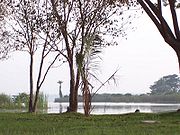
3. Krishnaraja Sagar
4. Kunti Betta
India
India , officially the Republic of India , is a country in South Asia. It is the seventh-largest country by geographical area, the second-most populous country with over 1.2 billion people, and the most populous democracy in the world...
n state
States and territories of India
India is a federal union of states comprising twenty-eight states and seven union territories. The states and territories are further subdivided into districts and so on.-List of states and territories:...
of Karnataka
Karnataka
Karnataka , the land of the Kannadigas, is a state in South West India. It was created on 1 November 1956, with the passing of the States Reorganisation Act and this day is annually celebrated as Karnataka Rajyotsava...
.
Geography
Pandavapura is located at 12.5°N 76.67°E. It has an average elevation of 709 metres (2326 feet). Earlier, Pandavapura was known as Hirode , Dandu , and French Rocks.Demographics
India censusCensus
A census is the procedure of systematically acquiring and recording information about the members of a given population. It is a regularly occurring and official count of a particular population. The term is used mostly in connection with national population and housing censuses; other common...
, Pandavapura had a population of 18,236. Males constitute 51% of the population and females 49%. Pandavapura has an average literacy rate of 67%, higher than the national average of 59.5%: male literacy is 72%, and female literacy is 62%. In Pandavapura, 12% of the population is under 6 years of age.
History
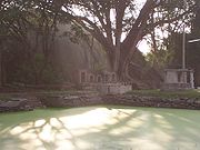
The name 'Pandavapura' means "Town of Pandavas". Mythology states that the Pandavas during their period of exile stayed here for sometime, and Kunti, mother of the Pandavas, liked the hillock so much that it became one of her favorite haunts. The town is also named after the Pandavas because of their brief stay in this region. The name "French Rock" dates back to India's Pre-Independence days, the place was used as the camping ground by the French army, which came to help Tippu Sultan in his war against the British. It is believed that French named the small town as "French Rocks", as the town is in the vicinity of two rocky hills. After Indian Independence these rocky hills called as "Kunti Betta" by locals.Pandavapura is approximately 130 km from Bangalore and 25 km from Mysore. It is a perfect destination for weekend get away.
About the Town
Pandavapura town is surrounded by beautiful paddy and sugar cane fields. Agriculture is the main occupation around the town. The town is surrounded by many villages and the town is central point for farmers everyday business. Every Thursday there will be farmer's market (called as "Santhe" in Kannada) in the heart of the town, where farmers directly sell their agricultural products. Apart from agricultural products, you can also find handicrafts, ayurvedic products etc.,. Surrounding villages have JaggeryJaggery
Jaggery is a traditional unrefined non-centrifugal whole cane sugar consumed in Asia, Africa, Latin America, and the Caribbean. It is a concentrated product of cane juice without separation of the molasses and crystals, and can vary from golden brown to dark brown in color...
manufacturing units and it is a nice experience to watch the process of making Jaggery out of sugar cane. The Visweswarayya Canal (VC Canal) flows in the heart of the town, by dividing the town into two halves. The water for this canal is sourced from the Krishnaraja Sagar (KRS), which is Reservoir across the river Cauvery
Kaveri River
The Kaveri , also spelled Cauvery in English, is a large Indian river. The origin of the river is traditionally placed at Talakaveri, Kodagu in the Western Ghats in Karnataka, flows generally south and east through Karnataka and Tamil Nadu and across the southern Deccan plateau through the...
.
Transport
Pandavapura is well connected by Train and Bus transportation. Most of the trains which run between Bangalore and Mysore stops in Pandavapura. The Pandavapura railway station is 4 km away from the Pandavapura town, there will be very frequent auto rickshaws and buses for Pandavapura town. There are very few direct buses runs from Bangalore to Pandavapura. However travelers from Bangalore, can first reach the Mandya town using Bus and then can get hold of local transport for Pandavapura in Mandya KSRTC bus stand. Train is the best and easiest mode of transportation for Pandavapura from Bangalore.Tourism
Pandavapura town is surrounded by well known tourist spots.Following are tourist spots:
1. Kere Thonnur
2. Melkote
Melkote
Melukote in Pandavapura taluk of Mandya district, Karnataka, in southern India, is one of the sacred places in Karnataka. The place is also known as Thirunarayanapuram. It is built on rocky hills, known as Yadavagiri or Yadugiri, overlooking the Cauvery valley. Melukote is about 51 km from...
3. Krishnaraja Sagar
Krishna Raja Sagara
Krishna Raja Sagara , also popularly known as KRS , is the name of both a lake and the dam that causes it. For information about the settlement near the dam and reservoir, see Krishnarajasagara. The dam is across Kaveri River, in Mandya District near Mysore in Karnataka state, India...
4. Kunti Betta