

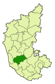
Chikmagalur District
Encyclopedia
Chikkamagaluru is a district in the India
n state of Karnataka
. Chikkamagaluru is where coffee was first cultivated in India. The mountains here which are a part of the Western Ghats
are the source of rivers like Tunga
and Bhadra
. Chikkamagaluru district also contains Mullayanagiri
; which is the highest peak in Karnataka. It is also a tourist's paradise containing hill stations like Kemmanagundi and Kudremukh
and waterfalls like Manikyadhara, Hebbe
, Kallathigiri. Chikkamagaluru district has a rich history as is seen in the Hoysala temple at Amrithapura. Wildlife enthusiasts would be interested in the Kudremukh National Park and Bhadra Wildlife Sanctuary
present in this district.
city. It is alternatively spelt as Chickmagalur or Chikmagalur. Chikkamagaluru literally means "The town of the younger daughter" in the native Kannada language. The town is said to have been given as a dowry to the younger daughter of Rukmangada, the legendary chief of Sakrepatna and hence the name. As one can guess, there is indeed a town called Hiremagaluru which means "The town of the elder daughter" which is about 5 km from Chikkamagaluru city.
Taluk that Sala, the founder of the Hoysala dynasty, killed the legendary tiger, immortalised in the Hoysala crest. However, scholars have found lot of inconsistencies in this story and it seems to be more of a folklore. However, it is known that Veera Ballala II
(1173 - 1220 CE), the great king of Hoysala empire, has built the Amriteshwara temple at Amrithapura in Tarikere
Taluk.
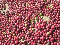
Coffee was introduced into India through the Chikkamagaluru district when the first coffee crop was grown in the Baba Budan Giri Hills during 1670 AD. According to the article Origins of Coffee, the saint Baba Budan
on his pilgrimage to Mecca
travelled through the seaport of Mocha, Yemen
where he discovered coffee. To introduce its taste to India, he wrapped seven coffee beans around his belly and got them out of Arabia. On his return home, he planted the beans in the hills of Chikkamagaluru, which are now named Baba Budan Hills in his honour.
In recent history, Chikkamagaluru was the centre of global attention in the year 1978 when the former Indian Prime Minister, Indira Gandhi
stood for elections here and got elected to Lok Sabha
, the Indian Parliament.
 Chikkamagaluru, the district head quarters of Chikkamagaluru district is 251 km from the state capital of Bangalore
and surrounded by the Baba Budan Giri hills and dense forests. The district is situated between 12° 54´ 42´´ and 13° 53´ 53´´ north latitude and between 75° 04´ 46´´ and 76° 21´ 50´´ east longitude. Its greatest length from east to west is about 138.4 kilometers and from north to south 88.5 kilometers. The district receives normal average rainfall of 1925 mm. The highest point in this district is Mullayanagiri, 1926 mts. above sea level which is also the highest point in the state of Karnataka. 30% of the district (2108.62 km²) is covered with forests. The district borders Shimoga district to the north, Davangere district to the north-east, Chitradurga
and Tumkur
districts to the east, Hassan district
to the south, Dakshina Kannada
district to the south-west and Udupi district to the west. The rivers Bhadra
, Tunga
, Hemavathi, Netravati, and Vedavathi
flow all year round. The district is rich in iron
, magnetite
and granite
deposits. Black soil is found around Baba Budan Giri Hills where as Red and Gravel soil are found in the southern parts of the district.
has a population
of 1,137,753 , roughly equal to the nation of Cyprus
or the US state of Rhode Island
. This gives it a ranking of 408th in India (out of a total of 640
). The district has a population density of 158 PD/sqkm . Its population growth rate
over the decade 2001-2011 was -0.28 %. Chikmagalur has a sex ratio
of 1005 females
for every 1000 males, and a literacy rate
of 79.24 %.
81% of the population resides in rural area with the remaining 19% being the urban population. Among Taluks, Sringeri taluk has the least population whereas Chikkamagaluru Taluk has the highest population.
 Chikkamagaluru district falls under the Mysore Division of Karnataka. It is divided into two Revenue Sub-divisions, Chikkamagaluru Sub-Division and Tarikere
Sub-Division. Chikkamagaluru Sub-Division comprises the taluks of Chikkamagaluru, Koppa, Mudigere
and Sringeri whereas the Tarikere Sub-Division comprises the taluks of Tarikere, Kadur
and Narasimharajapura
. The Deputy Commissioner (also the District Magistrate) is the functional head of the district. Each Sub-Division has Assistant Commissioners and each Taluk has Tahsildars who work under the control and supervision of the Deputy Commissioner. The current administrative setup of the district can be viewed here.
 Agriculture is the economical back bone of the Chikkamagaluru district with coffee
cultivation forming the major part of it. Agricultural production in the district is spread over three seasons — namely Kharif
, Rabi
and Summer. Important crops grown are cereals, i.e. rice, ragi
, jowar, maize and minor millets, pulses like red gram, horse gram
, green gram, avrekai (Hyacinth Beans
), black gram and Bengal gram. Oil seeds like groundnut
, sesamum
, sunflower, castor and commercial crops like sugarcane, cotton, and tobacco
are also grown here.
Coffee Board is the department located in Chikkamagaluru town that oversees the production and marketing of coffee cultivated in the district. Coffee is cultivated in Chikkamagaluru district in an area of around 85,465 hectares with Arabica
being the dominant variety grown in upper hills and Robusta being the major variety in the low level hills. There are around 15000 coffee growers in this district with 96% of them being small growers with holdings of less than or equal to 4 hectares. The average production is 55,000 MT: 35,000 MT of Arabica and 20,000 MT of Robusta. The average productivity per hectare is 810 kg for Arabica and 1110 kg of Robusta, which are higher than the national average.
There is only one Large Scale industry in this district, i.e. M/s Kudremukh
Iron Ore Company Ltd. (KIOCL) in Kudremukh area of Mudigere
Taluk. KIOCL was established in 1976 to develop the Kudremukh mine and to produce 7.5 million tonnes of concentrate per year. The facilities were commissioned in 1980 and the first shipment of concentrate was made in October 1981. A pelletisation plant with a capacity of 3 million tonnes per year was commissioned in 1987 for production of high quality blast furnace and direct reduction grade pellets for export. KIOCL received a massive setback when its mining licence expired and operations were stopped by the Supreme Court with effect from 31 Dec, 2005. With many of the employees losing their jobs and the social backlash that may result thereof, efforts are being made to generate jobs for these workers in other areas.
There is only one Medium Scale Industry, i.e. M/s Vignyan Industries Ltd. located in Tarikere town. A subsidiary of BEML
, it produces steel castings.
There are 2 Industrial Estates in Chikkamagaluru district, one located near Chikkamagaluru town and the other near Birur
in Kadur
Taluk. The Chikkamagaluru Industrial Estate is spread over 13.2 acres (53,418.6 m²) of land where the one at Birur is spread over 11.1 acres (44,920.1 m²). Karnataka Industrial Area Development Board (KIADB) is also developing an Industrial Area of over 145 acre (0.5867947 km²) near Amble village of Chikkamagaluru Taluk.
Primary and secondary education:
As of 2001, there are 1620 primary schools (with 151923 students) and 235 secondary schools (high schools with 34607 students) in Chikkamagaluru district. Chikkamagaluru Taluk with 414 primary schools (42774 students) has the most number of primary schools with Sringeri Taluk having the least number of 80 primary schools (5822 students). Kadur Taluk with 74 secondary schools (9990 students) has the most number of secondary schools with Sringeri Taluk having the least number of 9 secondary schools (1492 students).
Higher secondary education:
As of 2001, there are 46 colleges (with 4711 students) offering Higher Secondary (Pre-University) education in Chikkamagaluru district. Kadur Taluk with 12 Higher-Secondary colleges (1324 students) has the most number of Higher-secondary colleges with Sringeri Taluk having the least number of 2 Higher-secondary colleges (160 students).
Graduate education:
As of 2001, there are 13 degree colleges (with 4615 students) offering graduate education in Chikkamagaluru district which are affiliated to Kuvempu University
. Chikkamagaluru Taluk has the maximum 4 graduate colleges (with 1648 students) whereas Koppa, Mudigere
, Narasimharajapura
and Sringeri taluks have only 1 graduate college each.
Technical education:
Medical education:
The only source of medical education in the Chikkamagaluru district is Arror Laxminarayan Rao Memorial Ayurvedic Medical college in Koppa. This college offers the Bachelor of Ayurvedic Medicine and Surgery (BAMS) degree.
Chikkamagaluru district is not known for well maintained roads. The poor state of the roads has hampered development of this district to some extent; more so because of the absence of even a good rail network in this district. The total length of roads in this district is 7264 km. There are only two National Highways that pass through this district. The National Highway NH-13 (Sholapur to Mangalore
) passes through the towns of Koppa and Sringeri where as the National Highway NH-206 (Bangalore
to Honnavar) passes through the towns of Kadur, Birur and Tarikere. There is a proposal to upgrade the existing state highways Tarikere-Belur
, Sringeri-Hassan & Kadur-Mangalore to national highway status.
Rail:
The Kadur and Tarikere taluks have railway lines passing through them. The total length of railway line passing through the district is 91 km of which 51 km is in Kadur taluk and 40 km is in Tarikere taluk. Birur station is a major junction in this district where the railway line from Bangalore
bifurcates, with one line going towards Hubli and the other towards Shimoga. The district headquarters, Chikkamagaluru city does not have a railway station which is one of the reasons for the isolation of Chikkamagaluru city from the rest of the state. A new line is being laid between Kadur and Sakleshpur
in Hassan district
which should pass through Chikkamagaluru city.
Air:
Chikkamagaluru district does not have an airport. Airports at Mangalore
, Bangalore
and Hubli can be used as an alternative. However, there are plans to develop an airport near Marle village about 10 km from Chikkamagaluru city.


India
India , officially the Republic of India , is a country in South Asia. It is the seventh-largest country by geographical area, the second-most populous country with over 1.2 billion people, and the most populous democracy in the world...
n state of Karnataka
Karnataka
Karnataka , the land of the Kannadigas, is a state in South West India. It was created on 1 November 1956, with the passing of the States Reorganisation Act and this day is annually celebrated as Karnataka Rajyotsava...
. Chikkamagaluru is where coffee was first cultivated in India. The mountains here which are a part of the Western Ghats
Western Ghats
The Western Ghats, Western Ghauts or the Sahyādri is a mountain range along the western side of India. It runs north to south along the western edge of the Deccan Plateau, and separates the plateau from a narrow coastal plain along the Arabian Sea. The Western Ghats block rainfall to the Deccan...
are the source of rivers like Tunga
Tunga
Tunga may refer to:* Tunga River, a river in India* Tunga, Leyte, a municipality in the Philippines* Tunga, Trondheim, a location in Trondheim, Norway* Tunga , a Unicode typeface included in Windows XP that displays Kannada script...
and Bhadra
Bhadra
In Hinduism, Bhadra is a goddess of the hunt and one of Shiva's servants....
. Chikkamagaluru district also contains Mullayanagiri
Mullayanagiri
Mullayanagiri , is the highest peak in Karnataka, India. Mullayanagiri is located at in the Baba Budan Giri Range of the Western Ghats...
; which is the highest peak in Karnataka. It is also a tourist's paradise containing hill stations like Kemmanagundi and Kudremukh
Kudremukh
Kudremukh also spelled Kuduremukha is a mountain range in Chikkamagaluru district, in Karnataka, India. It is also the name of a small hill station town situated near the mountain, about 48 kilometers from Karkala and about 20 kilometers from Kalasa...
and waterfalls like Manikyadhara, Hebbe
Hebbe Falls
Hebbe Falls are situated about 10 km away from the famous hill station Kemmangundi in Karnataka, India. This waterfalls are inside a coffee estate and can be reached either by walk or four-wheeler....
, Kallathigiri. Chikkamagaluru district has a rich history as is seen in the Hoysala temple at Amrithapura. Wildlife enthusiasts would be interested in the Kudremukh National Park and Bhadra Wildlife Sanctuary
Bhadra Wildlife Sanctuary
Bhadra Wildlife Sanctuary is 38 km. northwest of Chikmagalur town in Karnataka state.It extends between 13º 25' and 13º 50' N latitude to 75º 15' and 75º 50' E longitude. The elevation gradient...
present in this district.
Etymology
Chikkamagalur district gets its name from its headquarters of ChikkamagaluruChikkamagaluru
Chikmagalur is a town located in Chikkamagaluru district in the Indian state of Karnataka. Located in the foothills of Mullayanagiri range chikmagalur is famous for the coffee, it is known as the coffee land of karnataka. it has international school called ambar valley and a star resort by name...
city. It is alternatively spelt as Chickmagalur or Chikmagalur. Chikkamagaluru literally means "The town of the younger daughter" in the native Kannada language. The town is said to have been given as a dowry to the younger daughter of Rukmangada, the legendary chief of Sakrepatna and hence the name. As one can guess, there is indeed a town called Hiremagaluru which means "The town of the elder daughter" which is about 5 km from Chikkamagaluru city.
History
Chikkamagaluru is the region where the Hoysala rulers started and spent the early days of their dynasty. According to a legend, it was at Sosevur, now identified with Angadi in MudigereMudigere
Mudigere is a panchayat town in Chikmagalur district in the Indian state of Karnataka. It is 35 km from the district headquarters. Several pilgrimage sites such as Dharmasthala , Horanadu, Kalasa, Sringeri are near to the town...
Taluk that Sala, the founder of the Hoysala dynasty, killed the legendary tiger, immortalised in the Hoysala crest. However, scholars have found lot of inconsistencies in this story and it seems to be more of a folklore. However, it is known that Veera Ballala II
Veera Ballala II
Veera Ballala II was the greatest monarch of the Hoysala Empire. This is proven by his successes against the Seuna, Southern Kalachuri, and the waning Kalyani Chalukya dynasties. He caused the demise of the Kalyani Chalukya dynasty. His period also saw prolific literary activity in Kannada. He...
(1173 - 1220 CE), the great king of Hoysala empire, has built the Amriteshwara temple at Amrithapura in Tarikere
Tarikere
Tarikere is a taluk in Chikmagalur district in the state of Karnataka of India. The headquarters of Tarikere taluk is a town of the same name. The town has derived its name from number of water tanks by which the town is surrounded namely, Chikkere, Doddakere, Dalavikere,...
Taluk.
Coffee was introduced into India through the Chikkamagaluru district when the first coffee crop was grown in the Baba Budan Giri Hills during 1670 AD. According to the article Origins of Coffee, the saint Baba Budan
Baba Budan
Baba Budan was a 17th century Sufi, revered by both Muslims and Hindus, whose shrine is at Baba Budangiri, Karnataka, India. He is said to have introduced the coffee plant to India by bringing seven beans from the port of Mocha, Yemen, which were then raised at the place that bears his...
on his pilgrimage to Mecca
Mecca
Mecca is a city in the Hijaz and the capital of Makkah province in Saudi Arabia. The city is located inland from Jeddah in a narrow valley at a height of above sea level...
travelled through the seaport of Mocha, Yemen
Mocha, Yemen
Mocha or Mokha is a port city on the Red Sea coast of Yemen. Until it was eclipsed in the 19th century by Aden and Hodeida, Mocha was the principal port for Yemen's capital Sana'a.-Overview:...
where he discovered coffee. To introduce its taste to India, he wrapped seven coffee beans around his belly and got them out of Arabia. On his return home, he planted the beans in the hills of Chikkamagaluru, which are now named Baba Budan Hills in his honour.
In recent history, Chikkamagaluru was the centre of global attention in the year 1978 when the former Indian Prime Minister, Indira Gandhi
Indira Gandhi
Indira Priyadarshini Gandhara was an Indian politician who served as the third Prime Minister of India for three consecutive terms and a fourth term . She was assassinated by Sikh extremists...
stood for elections here and got elected to Lok Sabha
Lok Sabha
The Lok Sabha or House of the People is the lower house of the Parliament of India. Members of the Lok Sabha are elected by direct election under universal adult suffrage. As of 2009, there have been fifteen Lok Sabhas elected by the people of India...
, the Indian Parliament.
Geography
Bangalore
Bengaluru , formerly called Bengaluru is the capital of the Indian state of Karnataka. Bangalore is nicknamed the Garden City and was once called a pensioner's paradise. Located on the Deccan Plateau in the south-eastern part of Karnataka, Bangalore is India's third most populous city and...
and surrounded by the Baba Budan Giri hills and dense forests. The district is situated between 12° 54´ 42´´ and 13° 53´ 53´´ north latitude and between 75° 04´ 46´´ and 76° 21´ 50´´ east longitude. Its greatest length from east to west is about 138.4 kilometers and from north to south 88.5 kilometers. The district receives normal average rainfall of 1925 mm. The highest point in this district is Mullayanagiri, 1926 mts. above sea level which is also the highest point in the state of Karnataka. 30% of the district (2108.62 km²) is covered with forests. The district borders Shimoga district to the north, Davangere district to the north-east, Chitradurga
Chitradurga
Chitradurga is a town in the southern part of the Indian state of Karnataka. It is also the headquarters of Chitradurga district. Chitradurga was also known by the names Chitradurg, Chitrakaladurga, Chittaldurg. Chittaldrug was the name officially used by the British Govt.-Geography:Chitradurga is...
and Tumkur
Tumkur
Tumkur is one of the busiest industrial towns located in the state of Karnataka. Since 28 August 2010, Tumkur has been accorded the status of a Corporation city. It is situated at a distance of 70 kilometers north west of the city of Bangalore along National Highway 4...
districts to the east, Hassan district
Hassan district
Hassan is a district in Karnataka state, India. The district headquarters are Hassan.Hassan district was the seat of the Hoysala Empire which at its peak ruled large parts of south India from Belur as its early capital and Halebidu as its later capital during the period 1000 - 1334 CE...
to the south, Dakshina Kannada
Dakshina Kannada
- Geography :The district geography consists of sea shore in the west and Western Ghats in the east. The major rivers are Netravathi, Kumaradhara, Phalguni, Shambhavi, Nandini or Pavanje and Payaswini which all join Arabian sea. Vast areas of evergreen forests which once covered this district, have...
district to the south-west and Udupi district to the west. The rivers Bhadra
Bhadra River
The Bhadra River is a river in Karnataka state in southern India.The Bhadra originates at Gangamoola near Kudremukha, Western Ghats range, and flows east across the southern part of Deccan Plateau, joined by its tributaries the Somavahini near Hebbe, Thadabehalla, and Odirayanahalla. It flows...
, Tunga
Tunga River
The Tunga River is a river in Karnataka state, southern India. The river is born in the Western Ghats on a hill known as Varaha Parvata at a place called Gangamoola. From here, the river flows through two districts in Karnataka - Chikmagalur District and Shimoga District. It is 147 km long and...
, Hemavathi, Netravati, and Vedavathi
Vedavathi River
The Vedavathi is a river in India. It rises from the Western Ghats and flows through the states of Karnataka and Andhra Pradesh before joining the Tungabhadra. The Vedavathi is also called the Hagari in parts of Andhra Pradesh...
flow all year round. The district is rich in iron
Iron
Iron is a chemical element with the symbol Fe and atomic number 26. It is a metal in the first transition series. It is the most common element forming the planet Earth as a whole, forming much of Earth's outer and inner core. It is the fourth most common element in the Earth's crust...
, magnetite
Magnetite
Magnetite is a ferrimagnetic mineral with chemical formula Fe3O4, one of several iron oxides and a member of the spinel group. The chemical IUPAC name is iron oxide and the common chemical name is ferrous-ferric oxide. The formula for magnetite may also be written as FeO·Fe2O3, which is one part...
and granite
Granite
Granite is a common and widely occurring type of intrusive, felsic, igneous rock. Granite usually has a medium- to coarse-grained texture. Occasionally some individual crystals are larger than the groundmass, in which case the texture is known as porphyritic. A granitic rock with a porphyritic...
deposits. Black soil is found around Baba Budan Giri Hills where as Red and Gravel soil are found in the southern parts of the district.
Demographics
According to the 2011 census2011 census of India
The 15th Indian National census was conducted in two phases, houselisting and population enumeration. Houselisting phase began on April 1, 2010 and involved collection of information about all buildings...
has a population
Demographics of India
The demographics of India are inclusive of the second most populous country in the world, with over 1.21 billion people , more than a sixth of the world's population. Already containing 17.5% of the world's population, India is projected to be the world's most populous country by 2025, surpassing...
of 1,137,753 , roughly equal to the nation of Cyprus
Cyprus
Cyprus , officially the Republic of Cyprus , is a Eurasian island country, member of the European Union, in the Eastern Mediterranean, east of Greece, south of Turkey, west of Syria and north of Egypt. It is the third largest island in the Mediterranean Sea.The earliest known human activity on the...
or the US state of Rhode Island
Rhode Island
The state of Rhode Island and Providence Plantations, more commonly referred to as Rhode Island , is a state in the New England region of the United States. It is the smallest U.S. state by area...
. This gives it a ranking of 408th in India (out of a total of 640
Districts of India
A district is an administrative division of an Indian state or territory. Districts are further subdivided, in some cases into Sub-Divisions, and otherwise directly into tehsils or talukas.District officials include:...
). The district has a population density of 158 PD/sqkm . Its population growth rate
Family planning in India
Family planning in India is based on efforts largely sponsored by the Indian government. In the 1965-2009 period, contraceptive usage has more than tripled and the fertility rate has more than halved , but the national fertility rate is still high enough to cause long-term population growth...
over the decade 2001-2011 was -0.28 %. Chikmagalur has a sex ratio
Sex ratio
Sex ratio is the ratio of males to females in a population. The primary sex ratio is the ratio at the time of conception, secondary sex ratio is the ratio at time of birth, and tertiary sex ratio is the ratio of mature organisms....
of 1005 females
Women in India
The status of women in India has been subject to many great changes over the past few millennia. From equal status with men in ancient times through the low points of the medieval period, to the promotion of equal rights by many reformers, the history of women in India has been eventful...
for every 1000 males, and a literacy rate
Literacy in India
Literacy in India is key for socio-economic progress, and the Indian literacy rate grew to 74.04% in 2011 from 12% at the end of British rule in 1947. Although this was a greater than sixfold improvement, the level is well below the world average literacy rate of 84%, and India currently has the...
of 79.24 %.
81% of the population resides in rural area with the remaining 19% being the urban population. Among Taluks, Sringeri taluk has the least population whereas Chikkamagaluru Taluk has the highest population.
Administration
Tarikere
Tarikere is a taluk in Chikmagalur district in the state of Karnataka of India. The headquarters of Tarikere taluk is a town of the same name. The town has derived its name from number of water tanks by which the town is surrounded namely, Chikkere, Doddakere, Dalavikere,...
Sub-Division. Chikkamagaluru Sub-Division comprises the taluks of Chikkamagaluru, Koppa, Mudigere
Mudigere
Mudigere is a panchayat town in Chikmagalur district in the Indian state of Karnataka. It is 35 km from the district headquarters. Several pilgrimage sites such as Dharmasthala , Horanadu, Kalasa, Sringeri are near to the town...
and Sringeri whereas the Tarikere Sub-Division comprises the taluks of Tarikere, Kadur
Kadur
Kadur is a taluk in Chikmagalur district, in the Indian state of Karnataka. It was formerly, a district in the Mysore state, with an area of 2813sq. m. Pop. , 362,752, showing an increase of 9% in the decade.-Geography:Kadur is located at...
and Narasimharajapura
Narasimharajapura
Narasimharajapura is a panchayat town in Chikmagalur district in the Indian state of Karnataka.-Geography:Narasimharajapura is located at . It has an average elevation of 643 metres...
. The Deputy Commissioner (also the District Magistrate) is the functional head of the district. Each Sub-Division has Assistant Commissioners and each Taluk has Tahsildars who work under the control and supervision of the Deputy Commissioner. The current administrative setup of the district can be viewed here.
Economy
Coffee
Coffee is a brewed beverage with a dark,init brooo acidic flavor prepared from the roasted seeds of the coffee plant, colloquially called coffee beans. The beans are found in coffee cherries, which grow on trees cultivated in over 70 countries, primarily in equatorial Latin America, Southeast Asia,...
cultivation forming the major part of it. Agricultural production in the district is spread over three seasons — namely Kharif
Kharif crop
The crops that are sown in the rainy season are called kharif crops.The Kharif crop is the autumn harvest in India and Pakistan. The term Kharif means "autumn" in Arabic Kharif crops are usually sown with the beginning of the first rains in July, during the south-west monsoon season...
, Rabi
Rabi crop
Different crops have different requirements for their proper growth , as they grow in different season . Based on the season in which they grow , crops are categorised as:-1.rabi crops2.kharif crops...
and Summer. Important crops grown are cereals, i.e. rice, ragi
Finger millet
Eleusine coracana, commonly Finger millet , also known as African millet or Ragi is an annual plant widely grown as a cereal in the arid areas of Africa and Asia. E...
, jowar, maize and minor millets, pulses like red gram, horse gram
Horse gram
Horse Gram is one of the lesser known beans. The whole seeds of horse gram are generally utilized as cattle feed. However, it is consumed as a whole seed, as sprouts, or as whole meal by a large population in rural areas of southern India. Medical uses of these legumes have been discussed...
, green gram, avrekai (Hyacinth Beans
Hyacinth bean
Lablab purpureus Lablab purpureus Lablab purpureus (syn. Dolichos lablab L., Dolichos purpureus L., L. niger Medikus, L. lablab (L.) Lyons, Vigna aristata Piper, and L...
), black gram and Bengal gram. Oil seeds like groundnut
Peanut
The peanut, or groundnut , is a species in the legume or "bean" family , so it is not a nut. The peanut was probably first cultivated in the valleys of Peru. It is an annual herbaceous plant growing tall...
, sesamum
Sesamum
Sesamum is a genus of approximately 20 species in the flowering plant family Pedaliaceae. The plants are annual or perennial herbs with edible seeds. The best-known member of the genus is sesame, Sesamum indicum , the source of sesame seeds. The species are primarily African, with some species...
, sunflower, castor and commercial crops like sugarcane, cotton, and tobacco
Tobacco
Tobacco is an agricultural product processed from the leaves of plants in the genus Nicotiana. It can be consumed, used as a pesticide and, in the form of nicotine tartrate, used in some medicines...
are also grown here.
Coffee Board is the department located in Chikkamagaluru town that oversees the production and marketing of coffee cultivated in the district. Coffee is cultivated in Chikkamagaluru district in an area of around 85,465 hectares with Arabica
Coffea arabica
Coffea arabica is a species of Coffea originally indigenous to the mountains of Yemen in the Arabian Peninsula, hence its name, and also from the southwestern highlands of Ethiopia and southeastern Sudan. It is also known as the "coffee shrub of Arabia", "mountain coffee" or "arabica coffee"...
being the dominant variety grown in upper hills and Robusta being the major variety in the low level hills. There are around 15000 coffee growers in this district with 96% of them being small growers with holdings of less than or equal to 4 hectares. The average production is 55,000 MT: 35,000 MT of Arabica and 20,000 MT of Robusta. The average productivity per hectare is 810 kg for Arabica and 1110 kg of Robusta, which are higher than the national average.
Industries
Chikkamagaluru district unfortunately has not made good progress in terms of Industrial Development. Inadequate infrastructure, poor roads, poor rail network and investors preferring non-industrial ventures over industrial ones are quoted as some of the reasons for the backwardness of Industrial Development in this district.There is only one Large Scale industry in this district, i.e. M/s Kudremukh
Kudremukh
Kudremukh also spelled Kuduremukha is a mountain range in Chikkamagaluru district, in Karnataka, India. It is also the name of a small hill station town situated near the mountain, about 48 kilometers from Karkala and about 20 kilometers from Kalasa...
Iron Ore Company Ltd. (KIOCL) in Kudremukh area of Mudigere
Mudigere
Mudigere is a panchayat town in Chikmagalur district in the Indian state of Karnataka. It is 35 km from the district headquarters. Several pilgrimage sites such as Dharmasthala , Horanadu, Kalasa, Sringeri are near to the town...
Taluk. KIOCL was established in 1976 to develop the Kudremukh mine and to produce 7.5 million tonnes of concentrate per year. The facilities were commissioned in 1980 and the first shipment of concentrate was made in October 1981. A pelletisation plant with a capacity of 3 million tonnes per year was commissioned in 1987 for production of high quality blast furnace and direct reduction grade pellets for export. KIOCL received a massive setback when its mining licence expired and operations were stopped by the Supreme Court with effect from 31 Dec, 2005. With many of the employees losing their jobs and the social backlash that may result thereof, efforts are being made to generate jobs for these workers in other areas.
There is only one Medium Scale Industry, i.e. M/s Vignyan Industries Ltd. located in Tarikere town. A subsidiary of BEML
BEML
Bharat Earth Movers Limited now known as BEML is an Indian Public Sector Undertaking, with headquarters in Bangalore. It manufactures a variety of heavy equipment, such as that used for earth moving, transport and mining....
, it produces steel castings.
There are 2 Industrial Estates in Chikkamagaluru district, one located near Chikkamagaluru town and the other near Birur
Birur
Birur is a town located in Kadur Taluk in Chikkamagaluru district in the state of Karnataka, India.- Geography :Birur is located at . It has an average elevation of 833 metres . It is called as Gateway to Malnad region.- Transport :...
in Kadur
Kadur
Kadur is a taluk in Chikmagalur district, in the Indian state of Karnataka. It was formerly, a district in the Mysore state, with an area of 2813sq. m. Pop. , 362,752, showing an increase of 9% in the decade.-Geography:Kadur is located at...
Taluk. The Chikkamagaluru Industrial Estate is spread over 13.2 acres (53,418.6 m²) of land where the one at Birur is spread over 11.1 acres (44,920.1 m²). Karnataka Industrial Area Development Board (KIADB) is also developing an Industrial Area of over 145 acre (0.5867947 km²) near Amble village of Chikkamagaluru Taluk.
Education
According to 2001 census, the percentage literacy rate of Chikkamagaluru district is 72.63% with 80.68% of males and 64.47% of females being literate. The literacy rate of Chikkamagaluru is higher than the average literacy rate of Karnataka state which is 67.04%. Sringeri Taluk has the highest literacy rate of 80.78% and Kadur Taluk with 68.33% being the least literate one.Primary and secondary education:
As of 2001, there are 1620 primary schools (with 151923 students) and 235 secondary schools (high schools with 34607 students) in Chikkamagaluru district. Chikkamagaluru Taluk with 414 primary schools (42774 students) has the most number of primary schools with Sringeri Taluk having the least number of 80 primary schools (5822 students). Kadur Taluk with 74 secondary schools (9990 students) has the most number of secondary schools with Sringeri Taluk having the least number of 9 secondary schools (1492 students).
Higher secondary education:
As of 2001, there are 46 colleges (with 4711 students) offering Higher Secondary (Pre-University) education in Chikkamagaluru district. Kadur Taluk with 12 Higher-Secondary colleges (1324 students) has the most number of Higher-secondary colleges with Sringeri Taluk having the least number of 2 Higher-secondary colleges (160 students).
Graduate education:
As of 2001, there are 13 degree colleges (with 4615 students) offering graduate education in Chikkamagaluru district which are affiliated to Kuvempu University
Kuvempu University
Kuvempu University is a public state university located in Shimoga, Karnataka, India established in 1987 by the act of the Karnataka state legislature through an amendment No.28/1976 dated 29 January 1989 under the Karnataka State University Act 1976. The university offers undergraduate and...
. Chikkamagaluru Taluk has the maximum 4 graduate colleges (with 1648 students) whereas Koppa, Mudigere
Mudigere
Mudigere is a panchayat town in Chikmagalur district in the Indian state of Karnataka. It is 35 km from the district headquarters. Several pilgrimage sites such as Dharmasthala , Horanadu, Kalasa, Sringeri are near to the town...
, Narasimharajapura
Narasimharajapura
Narasimharajapura is a panchayat town in Chikmagalur district in the Indian state of Karnataka.-Geography:Narasimharajapura is located at . It has an average elevation of 643 metres...
and Sringeri taluks have only 1 graduate college each.
Technical education:
- EngineeringEngineeringEngineering is the discipline, art, skill and profession of acquiring and applying scientific, mathematical, economic, social, and practical knowledge, in order to design and build structures, machines, devices, systems, materials and processes that safely realize improvements to the lives of...
: There is one Engineering College located in Chikkamagaluru city, i.e. Sri Adichunchanagiri Institute of Technology. The courses offered here are Mechanical Engineering, Computer Science Engineering, Electronics and Communication Engineering, Electrical and Electronics Engineering, Information Science and technology, Industrial producation Engineering, Environmental Engineering and Civil Engineering. This college is affiliated to Visweswariah Technological University located at BelgaumBelgaumBelgaum is a city and a municipal corporation in Belgaum district in the state of Karnataka, India. It is the fourth largest city of the state of Karnataka, the first three being Bangalore, Mysore, Hubli-Dharwad....
.
- Polytechnics: There are 3 polytechnics offering diploma courses to students in Chikkamagaluru district. They are:
- Adichunchanagiri Polytechnic, Chikkamagaluru: Offering Diploma courses in Electronics and Communication and Computer Science
- DACG (GOVT) Polytechnic, Chikkamagaluru: Offering Diploma courses in Civil Engineering, Electrical Engineering, Mechanical Engineering , Automobile Engineering, Computer Science and Engineering, Electronics and Communication Engineering
- SJMM Vidyapeeta Polytechnic, Birur: Offering Diploma courses in Civil Engineering and Telecommunication Engineering.
- Industrial Training Institutes: There are 7 Industrial training institutes in Chikkamagaluru district. They are:
- Government Industrial Training Institute, Chikkamagaluru
- Government Industrial Training Institute, Kadur
- SDM Industrial Training Institute, Samse, Mudigere Taluk
- SJR Industrial Training Institute, Balehonnur, Narasimharajapura Taluk
- SJM Industrial Training Institute, Birur, Kadur Taluk
- Karnataka Industrial Training Institute, Chikkamagaluru
- Lakshmisha Industrial Training Institute, Devanoor, Kadur Taluk.
- Maruthi Industrial Training Institute, Kadur
Medical education:
The only source of medical education in the Chikkamagaluru district is Arror Laxminarayan Rao Memorial Ayurvedic Medical college in Koppa. This college offers the Bachelor of Ayurvedic Medicine and Surgery (BAMS) degree.
Transport
Road:Chikkamagaluru district is not known for well maintained roads. The poor state of the roads has hampered development of this district to some extent; more so because of the absence of even a good rail network in this district. The total length of roads in this district is 7264 km. There are only two National Highways that pass through this district. The National Highway NH-13 (Sholapur to Mangalore
Mangalore
Mangalore is the chief port city of the Indian state of Karnataka. It is located about west of the state capital, Bangalore. Mangalore lies between the Arabian Sea and the Western Ghat mountain ranges, and is the administrative headquarters of the Dakshina Kannada district in south western...
) passes through the towns of Koppa and Sringeri where as the National Highway NH-206 (Bangalore
Bangalore
Bengaluru , formerly called Bengaluru is the capital of the Indian state of Karnataka. Bangalore is nicknamed the Garden City and was once called a pensioner's paradise. Located on the Deccan Plateau in the south-eastern part of Karnataka, Bangalore is India's third most populous city and...
to Honnavar) passes through the towns of Kadur, Birur and Tarikere. There is a proposal to upgrade the existing state highways Tarikere-Belur
Belur
Belur may refer to any of the following:* Belur, Karnataka, town in Karnataka, India* Belur, West Bengal, India, a locality on the west bank of the Hooghly River* Belur Math, the religious abbey located in Belur, West Bengal, India...
, Sringeri-Hassan & Kadur-Mangalore to national highway status.
Rail:
The Kadur and Tarikere taluks have railway lines passing through them. The total length of railway line passing through the district is 91 km of which 51 km is in Kadur taluk and 40 km is in Tarikere taluk. Birur station is a major junction in this district where the railway line from Bangalore
Bangalore
Bengaluru , formerly called Bengaluru is the capital of the Indian state of Karnataka. Bangalore is nicknamed the Garden City and was once called a pensioner's paradise. Located on the Deccan Plateau in the south-eastern part of Karnataka, Bangalore is India's third most populous city and...
bifurcates, with one line going towards Hubli and the other towards Shimoga. The district headquarters, Chikkamagaluru city does not have a railway station which is one of the reasons for the isolation of Chikkamagaluru city from the rest of the state. A new line is being laid between Kadur and Sakleshpur
Sakleshpur
Sakleshapur or Sakaleshpura in Kannada is a taluk and hill station town in Hassan district in the South Indian state of Karnataka....
in Hassan district
Hassan district
Hassan is a district in Karnataka state, India. The district headquarters are Hassan.Hassan district was the seat of the Hoysala Empire which at its peak ruled large parts of south India from Belur as its early capital and Halebidu as its later capital during the period 1000 - 1334 CE...
which should pass through Chikkamagaluru city.
Air:
Chikkamagaluru district does not have an airport. Airports at Mangalore
Mangalore
Mangalore is the chief port city of the Indian state of Karnataka. It is located about west of the state capital, Bangalore. Mangalore lies between the Arabian Sea and the Western Ghat mountain ranges, and is the administrative headquarters of the Dakshina Kannada district in south western...
, Bangalore
Bangalore
Bengaluru , formerly called Bengaluru is the capital of the Indian state of Karnataka. Bangalore is nicknamed the Garden City and was once called a pensioner's paradise. Located on the Deccan Plateau in the south-eastern part of Karnataka, Bangalore is India's third most populous city and...
and Hubli can be used as an alternative. However, there are plans to develop an airport near Marle village about 10 km from Chikkamagaluru city.
Hill stations
- KemmangundiKemmangundiKemmannugundi is a hill station in Tarikere taluk of Chikkamagaluru district in the state of Karnataka, India. It is 1434m above sea level. This was the summer retreat of Krishnaraja Wodeyar IV and as a mark of respect to the king, it is also known as Sri Krishnarajendra Hill Station...
: 55 km north from Chikkamagaluru town is Kemmangundi, a scenic hill station on the Baba Budan Giri range of hills. Kemmangundi is also known as K.R. Hills after the Wodeyar King, Krishnaraja Wodeyar, who had made it his favourite summer camp. Kemmangundi, at a height of 1,434 meters, is surrounded by thick forests and a salubrious climate throughout the year. It is surrounded by the Baba Budan Giri range and blessed with silver cascades of mountain streams and lush vegetation. Its beautifully laid out ornamental gardens and enchanting mountain and valley views are a treat to the eye. Spectacular sunsets are a must see from various locations in the district, even from the Raj Bhavan. For the adventurous, Kemmangundi offers many peaks to scale and intricate jungle paths to explore. This place has a beautiful rose garden and other attractions. There is a place called Z-point at about 10 minutes walk from this main place which gives a nice aerial view of the SholaSholaSholas are patches of stunted evergreen tropical and subtropical moist broadleaf forest found in valleys amid rolling grassland in the higher montane regions of South India. These patches of shola forest are found mainly in the valleys and are usually separated from one another by undulating...
grass lands of the Western Ghats. It was popularised by the reference in a Tamil film Kamal Haasan's Panchatantiram.
- KudremukhKudremukhKudremukh also spelled Kuduremukha is a mountain range in Chikkamagaluru district, in Karnataka, India. It is also the name of a small hill station town situated near the mountain, about 48 kilometers from Karkala and about 20 kilometers from Kalasa...
and Kudremukh National Park: 95 km southwest of Chikkamagaluru town is Kudremukh range (in Kannada Kudure = horse and mukha = face), so named because of the unique shape of the Kudremukh peak. Overlooking the Arabian SeaArabian SeaThe Arabian Sea is a region of the Indian Ocean bounded on the east by India, on the north by Pakistan and Iran, on the west by the Arabian Peninsula, on the south, approximately, by a line between Cape Guardafui in northeastern Somalia and Kanyakumari in India...
, the broad hills are chained to one another with deep valley & steep precipices. Situated at 1,894.3 meters above sea level, Kudremukh is rich in iron ore deposits. The Kudremukh Iron Ore Company conducts mining operations, benefaction and transportation of the ore as slurry through pipelines to the port at PanamburPanamburPanambur is the site of New Mangalore Port. It is located in Dakshina Kannada district of Karnataka state, India, north of the Gurupura river. The name Panambur is derived from 'Panam' which means Money and 'Ur' which means place or village in Tulu language.There is a Nandaneshwara temple in...
near MangaloreMangaloreMangalore is the chief port city of the Indian state of Karnataka. It is located about west of the state capital, Bangalore. Mangalore lies between the Arabian Sea and the Western Ghat mountain ranges, and is the administrative headquarters of the Dakshina Kannada district in south western...
.
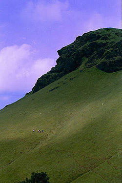
- MullayanagiriMullayanagiriMullayanagiri , is the highest peak in Karnataka, India. Mullayanagiri is located at in the Baba Budan Giri Range of the Western Ghats...
: Mullayanagiri is part of the Baba Budan Giri Hill Ranges here. It stands 1930 meters tall and is the tallest peak in Karnataka. Its height is famous mostly for watching sunsets from. It is 16 km from Chikkamagaluru town. Driving to Mullayanagiri is worth taking a risk. On the way is Sitalayanagiri where the water in the ShivaShivaShiva is a major Hindu deity, and is the destroyer god or transformer among the Trimurti, the Hindu Trinity of the primary aspects of the divine. God Shiva is a yogi who has notice of everything that happens in the world and is the main aspect of life. Yet one with great power lives a life of a...
temple neither increases nor decreases. The road to Mullayanagiri is very narrow with a views from steep cliffs. Driving to the peak is not possible and includes a trek up the hill from the half way point. There is a small temple on top of the hill. From the topmost point of the hill the Arabian Sea is visible on clear days. The small hillock in the temple compound is the highest point in Karnataka. The narrow road to the temple makes two way traffic impossible. It is a great trekking spot in Karnataka.
- Baba Budan Giri (Datta peeta): To the north of Chikkamagaluru town is the Baba Budan Giri Range or Chandra Drona Parvatha as it was known in the ancient times, which has one of the highest mountain peaks between the HimalayasHimalayasThe Himalaya Range or Himalaya Mountains Sanskrit: Devanagari: हिमालय, literally "abode of snow"), usually called the Himalayas or Himalaya for short, is a mountain range in Asia, separating the Indian subcontinent from the Tibetan Plateau...
and the NilgirisNilgiris (mountains)The Nilgiri , often referred to as the Nilgiri Hills, are a range of mountains with at least 24 peaks above , in the westernmost part of Tamil Nadu state at the junction of Karnataka and Kerala states in Southern India...
. The peak takes its name from the Muslim saint, Baba Budan, who resided here more than 150 years ago.
Waterfalls and lakes
- Manikyadhara Falls is a waterfall near the famous pilgrim centre Baba Budan Giri Dattatreya Peetha where water spills down like small pearls giving the visitors a memorable shower bath.
- Kallathigiri Falls: Just 10 km away from KemmangundiKemmangundiKemmannugundi is a hill station in Tarikere taluk of Chikkamagaluru district in the state of Karnataka, India. It is 1434m above sea level. This was the summer retreat of Krishnaraja Wodeyar IV and as a mark of respect to the king, it is also known as Sri Krishnarajendra Hill Station...
is Kallahathigiri falls, also known as Kalahasti falls. Water cascades down from the top of the Chandra Drona hill from a height of 122 meters amidst fascinating scenery. There is an old Veerabhadra temple dedicated to Lord ShivaShivaShiva is a major Hindu deity, and is the destroyer god or transformer among the Trimurti, the Hindu Trinity of the primary aspects of the divine. God Shiva is a yogi who has notice of everything that happens in the world and is the main aspect of life. Yet one with great power lives a life of a...
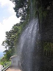
, constructed in a gap between rocks. This temple can be approached after crossing the waterfall. - Hebbe FallsHebbe FallsHebbe Falls are situated about 10 km away from the famous hill station Kemmangundi in Karnataka, India. This waterfalls are inside a coffee estate and can be reached either by walk or four-wheeler....
: This beautiful waterfall is over 10 km away from the famous hill station, KemmangundiKemmangundiKemmannugundi is a hill station in Tarikere taluk of Chikkamagaluru district in the state of Karnataka, India. It is 1434m above sea level. This was the summer retreat of Krishnaraja Wodeyar IV and as a mark of respect to the king, it is also known as Sri Krishnarajendra Hill Station...
. Here water streams down from a height of 168 meters in two stages to form Dodda Hebbe (Big Falls) and Chikka Hebbe (Small Falls). - Shanti Falls: This is a beautiful waterfall on the way to Z-Point in KemmangundiKemmangundiKemmannugundi is a hill station in Tarikere taluk of Chikkamagaluru district in the state of Karnataka, India. It is 1434m above sea level. This was the summer retreat of Krishnaraja Wodeyar IV and as a mark of respect to the king, it is also known as Sri Krishnarajendra Hill Station...
. - Hanumana Gundi Falls: Located 32 km. from the KalasaKalasaKalasa is a holy temple-town located in Chickmagalur district in Karnataka. Kalasa is home to the Kalaseshwara Temple dedicated to Lord Shiva. Kalasa lies 92 Kilometres South-west of Chickmagalur and is located on the banks of the Bhadra River....
, the waterfall has water falling on to Natural rock formations from a height of more than 100 feet (30.5 m). - Kadambi Falls: This is a waterfall located in the Kudremukh National Park.
- Sirimane FallsSirimane FallsSirimane Falls is one among the many waterfalls of the Western Ghats of Karnataka.-Location:Sirimane Falls is located at a distance of 5 km from Kigga near Sringeri, a popular pilgrim center. Nearest Airport is Mangalore and nearest Railway station is Shimoga....
: This is a waterfall located about 14 km from Sringeri town.
- Hirekolale lake:Near Chikmagalur town.
- Ayyenkere lake: Located 20 km from Chikmagalur.
Temple towns
- Sringeri: 90 km west of Chikkamagaluru town is Sringeri situated on the banks of Tunga, a Vedic Peetha established by Sri Adi ShankaraAdi ShankaraAdi Shankara Adi Shankara Adi Shankara (IAST: pronounced , (Sanskrit: , ) (788 CE - 820 CE), also known as ' and ' was an Indian philosopher from Kalady of present day Kerala who consolidated the doctrine of advaita vedānta...
, the exponent of the Advaita philosophy in 9th Century A.D. It is famous for Vidyashankara Temple originally constructed by the Hoysalas and later completed by the founders of the Vijayanagar Empire and Sharada temple, an early 20th. century addition. In the Vidya Shankara shrine, there are 12 zodiac pillars, which are so constructed that the rays of the sun fall on the pillar corresponding to the month.
- HoranaduHoranaduHoranadu is a Hindu holy city located in Chickmagalur district, Karnataka, India. The deity at the Annapoorneshwari Temple at Horanadu is Annapurneshwari...
: Horanadu is 100 km southwest of Chikkamagaluru and has an ancient Annapoorneshwari TempleAnnapoorneshwari TempleThe Annapoorneshwari Temple is located at Horanadu India 100 km from Chikmagalur in the thick forests and valleys of the Western Ghats of Karnataka...
, which has been renovated recently. With the installation of the new image of Adi Shakti, now the temple is called Adi-Shaktyatmaka Shri Annapoorneshwari. The place attracts lots of pilgrims who are provided free boarding and lodging by the temple.
- KalasaKalasaKalasa is a holy temple-town located in Chickmagalur district in Karnataka. Kalasa is home to the Kalaseshwara Temple dedicated to Lord Shiva. Kalasa lies 92 Kilometres South-west of Chickmagalur and is located on the banks of the Bhadra River....
: Kalasa is 92 km southwest of Chikkamagaluru and situated on the banks of the river BhadraBhadraIn Hinduism, Bhadra is a goddess of the hunt and one of Shiva's servants....
. It is surrounded by lofty hills of the Western Ghats and is looked upon as one of the pancha-kshetras on the banks of the Bhadra. Close by are the pancha theerthas, the five sacred ponds. On a small hillock here is the Kalaseshwara temple in dedicated to Ishwara, with a Kshetrapala shrine of soap stone in Hoysala style nearby. The Madhawacharya bande, a large boulder at one of the theerthas here, is supposed to have been placed by Shri Madhawacharya the founder of the DvaitaDvaitaDvaita is a school of Vedanta founded by Shri Madhvacharya....
school of philosophy. A statue of this acharya is carved on the upper portion of the rock.
- Guru Dattatreya Bababudanswamy Darga: Situated on the Baba Budan Giri is the Inam Dattatreya Peetha venerated by the Hindus and the Muslims alike. A laterite cave here is believed to have been sanctified by the residence of Dattatreya Swami as well as Hazrat Dada Hayat Mir Khalander. The worship here is conducted by a fakir and the annual jatra or urs is attended by both Hindus and Muslims with great fervors.
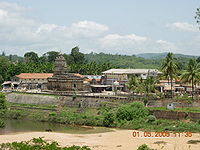
- Amritapura: 67 km north of Chikkamagaluru, Amrithapura is known for the Amritheshwara temple built in 1196 A.D by Amriteshwara Dandanayaka, a general of the Hoysala ruler Veera BallalaVeera BallalaVeera Ballala is the name of multiple South Indian kings of the Hoysala Empire:* Veera Ballala I 1102 - 1108 CE* Veera Ballala II 1173-1220 CE* Veera Ballala III 1291-1343 CE...
II. Delicacy of touch, originality of design and fine features have made this temple one of the notable structures of the Hoysala period.
- BelavadiBelavadiThe Veera Narayana temple is located in Belavadi , a village in Chikmagalur district of Karnataka state, India. The temple was built by the Hoysala Empire.This village was also known as Ekachakranagara, a place mentioned in Mahabharatha where Bheemasena killed the demon Bakasura and protected the...
: Located 29 km southeast of Chikkamagaluru town on the Chikkamagaluru-Javagal road and 10 km north west of HalebiduHalebiduHalebidu is located in Hassan District, Karnataka, India. Halebidu was the regal capital of the Hoysala Empire in the 12th century. It is home to one of the best examples of Hoysala architecture in the ornate Hoysaleswara and Kedareswara temples. Halebidu literally means ruined city...
, Belavadi is famous for Ornate temple of Veeranarayana. Belavadi is also famous for the temple of 'Udbhava Ganapathi'.
Wildlife
- Bhadra Wildlife SanctuaryBhadra Wildlife SanctuaryBhadra Wildlife Sanctuary is 38 km. northwest of Chikmagalur town in Karnataka state.It extends between 13º 25' and 13º 50' N latitude to 75º 15' and 75º 50' E longitude. The elevation gradient...
: Occupying 495 km². of wildlife sanctuary and Project tiger reserve, this region is an important watershed of the Tungabhadra riverTungabhadra RiverThe Tungabhadra River is a sacred river in southern India that flows through the state of Karnataka to Andhra Pradesh, where it serves as the chief tributary of the Krishna River...
. The huge reservoir here is the main water supplyWater supplyWater supply is the provision of water by public utilities, commercial organisations, community endeavours or by individuals, usually via a system of pumps and pipes...
to several districts in the rain shadow regions of south Karnataka. The forests here are rich in BambooBambooBamboo is a group of perennial evergreens in the true grass family Poaceae, subfamily Bambusoideae, tribe Bambuseae. Giant bamboos are the largest members of the grass family....
and birds species unique to both the Malabar and Sahyadri ranges.
- Kudremukh National Park: The Kudremukh National Park (latitudinal range 13°01'00" to 13°29'17" N, longitudinal range 75°00'55' to 75°25'00" E) is the largest declared Wildlife Protected Area (600 km²) of a tropical wet evergreen type of forest in the Western Ghats. The Western Ghats is one of the twenty-five hot spots identified for bio-diversity conservation in the world. Kudremukh National Park comes under the Global Tiger Conservation Priority-I, under the format developed jointly by Wildlife Conservation Society (WCS) and World Wide Fund-USA.