
Hiriyur
Encyclopedia
Hiriyur is a town
and taluk capital located near Chitradurga
in the India
n state of Karnataka
.
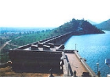
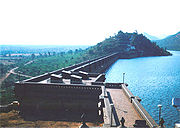
Hiriyur is renowned for having the oldest dam in Karnataka
, built on the Vedavati
river, and named Mari Kanive
. The Water on the dam looks exactly the preindipendce India Map. Hiryur is situated along National Highway 4. Hiriyur is located 160 km north of Bangalore. All the buses from Bangalore going towards Hubli, Belgaum, Davanagere, Bellary pass through Hiriyur.
It has a normally dry climate, with low rain fall. During winter (November - February) night temperature may come down up to 18 degrees.
, which is an architectural masterpiece constructed during the rule of the Mysore Wodeyar
s. C.N. Malige is one of the villages of Hiriyur taluk and it is situated between Hulithotlu and Adiralu villages. Sub office to this village is Aimangala. The national highway 4 which passes through Hiriyur has for decades created a cluster of business catering to the commuters.
Hiriyur is also famous for its 500+year old temple of lord shiva. it is called as "Terumalleshwara temple" it is also called as "dakshina kashi" by its devotees.it is believed that famous devotee of lord shiva "belavadi mallamma" was a resident of this town. every year she used to travel to varanasi by foot, as she grew older and weaker, one day she prayed to her lord that "o lord i have become old and weak i am not able to visit varanasi and have your darshan, what do i do". on the night of that day lord shiva appeared in her dream and told her that she need not come to varanasi to see him, he himself will come and reside in Hiriyur. As promised lord shiva was believed to have incarnated in the "oralukallu" (a stone of cylindrical shape used in the households of ancient india for grinding purpose). That stone which was worshipped by mallamma later became known as terumalleshwara.
The ancient name of hiriyur was "Ghanapuri".
near hiriyur there is another engineering marvel. it is called "yeppattu kannina setuve" (the seventy eyed bridge) the patterns in the bridge resemble human eye, and there are seventy eyes like that.if u happen to stand near the 70 eye of the bridge it is said that one could all the way look up to the 70th eye. but that is not possible now, due to lack of care many eyes are now covered by mud.this engineering marvel needs attention.
, Hiriyur had a population of 48,772. Males constitute 51% of the population and females 49%. Hiriyur has an average literacy rate of 69%, higher than the national average of 59.5%: male literacy is 75%, and female literacy is 62%. In Hiriyur, 12% of the population is under 6 years of age.
. This place lies on NH4, the Mumbai-Bangalore National Highway, and is a central place for most commuters travelling to southern and central parts of India
via Karnataka. Several villages around Hiriyur like Adivala, have been major producers of coconuts.
Town
A town is a human settlement larger than a village but smaller than a city. The size a settlement must be in order to be called a "town" varies considerably in different parts of the world, so that, for example, many American "small towns" seem to British people to be no more than villages, while...
and taluk capital located near Chitradurga
Chitradurga
Chitradurga is a town in the southern part of the Indian state of Karnataka. It is also the headquarters of Chitradurga district. Chitradurga was also known by the names Chitradurg, Chitrakaladurga, Chittaldurg. Chittaldrug was the name officially used by the British Govt.-Geography:Chitradurga is...
in the India
India
India , officially the Republic of India , is a country in South Asia. It is the seventh-largest country by geographical area, the second-most populous country with over 1.2 billion people, and the most populous democracy in the world...
n state of Karnataka
Karnataka
Karnataka , the land of the Kannadigas, is a state in South West India. It was created on 1 November 1956, with the passing of the States Reorganisation Act and this day is annually celebrated as Karnataka Rajyotsava...
.
Hiriyur is renowned for having the oldest dam in Karnataka
Karnataka
Karnataka , the land of the Kannadigas, is a state in South West India. It was created on 1 November 1956, with the passing of the States Reorganisation Act and this day is annually celebrated as Karnataka Rajyotsava...
, built on the Vedavati
Vedavati
In Hindu mythology, Vedavati is speculated to have been the spirit of Sita Devi, the wife of Lord Rama in the epic Ramayana. She was another avatar of Devi Laxmi.-Early life:...
river, and named Mari Kanive
Mari Kanive
Mari Kanive is a dam near Hiriyur Taluk, Chitradurga District, in the Indian state of Karnataka. It is the oldest dam in the state.The dam was built by the Mysore Maharajas pre-independence across the river Vedavathi...
. The Water on the dam looks exactly the preindipendce India Map. Hiryur is situated along National Highway 4. Hiriyur is located 160 km north of Bangalore. All the buses from Bangalore going towards Hubli, Belgaum, Davanagere, Bellary pass through Hiriyur.
It has a normally dry climate, with low rain fall. During winter (November - February) night temperature may come down up to 18 degrees.
History
Hiriyur is famous as a centre for regional (rural) markets. The 'santhe' attracts people from all over the district. It is also famous for the Mari KaniveMari Kanive
Mari Kanive is a dam near Hiriyur Taluk, Chitradurga District, in the Indian state of Karnataka. It is the oldest dam in the state.The dam was built by the Mysore Maharajas pre-independence across the river Vedavathi...
, which is an architectural masterpiece constructed during the rule of the Mysore Wodeyar
Wodeyar
The Wodeyar dynasty was an Indian royal dynasty that ruled the Kingdom of Mysore from 1399 to 1947, until the independence of India from British rule and the subsequent unification of the Indian dominion and princely states into the Republic of India.The spelling Wodeyar/Wadiyar is found in most...
s. C.N. Malige is one of the villages of Hiriyur taluk and it is situated between Hulithotlu and Adiralu villages. Sub office to this village is Aimangala. The national highway 4 which passes through Hiriyur has for decades created a cluster of business catering to the commuters.
Hiriyur is also famous for its 500+year old temple of lord shiva. it is called as "Terumalleshwara temple" it is also called as "dakshina kashi" by its devotees.it is believed that famous devotee of lord shiva "belavadi mallamma" was a resident of this town. every year she used to travel to varanasi by foot, as she grew older and weaker, one day she prayed to her lord that "o lord i have become old and weak i am not able to visit varanasi and have your darshan, what do i do". on the night of that day lord shiva appeared in her dream and told her that she need not come to varanasi to see him, he himself will come and reside in Hiriyur. As promised lord shiva was believed to have incarnated in the "oralukallu" (a stone of cylindrical shape used in the households of ancient india for grinding purpose). That stone which was worshipped by mallamma later became known as terumalleshwara.
The ancient name of hiriyur was "Ghanapuri".
near hiriyur there is another engineering marvel. it is called "yeppattu kannina setuve" (the seventy eyed bridge) the patterns in the bridge resemble human eye, and there are seventy eyes like that.if u happen to stand near the 70 eye of the bridge it is said that one could all the way look up to the 70th eye. but that is not possible now, due to lack of care many eyes are now covered by mud.this engineering marvel needs attention.
Geography
Hiriyur is located at 13.95°N 76.62°E. It has an average elevation of 630 metres (2066 feet). The months of March and April are the hottest months of the year.Demographics
India censusCensus
A census is the procedure of systematically acquiring and recording information about the members of a given population. It is a regularly occurring and official count of a particular population. The term is used mostly in connection with national population and housing censuses; other common...
, Hiriyur had a population of 48,772. Males constitute 51% of the population and females 49%. Hiriyur has an average literacy rate of 69%, higher than the national average of 59.5%: male literacy is 75%, and female literacy is 62%. In Hiriyur, 12% of the population is under 6 years of age.
Regional
The Vedavati river is dammed here to meet the water needs of the otherwise mostly dry district of ChitradurgaChitradurga
Chitradurga is a town in the southern part of the Indian state of Karnataka. It is also the headquarters of Chitradurga district. Chitradurga was also known by the names Chitradurg, Chitrakaladurga, Chittaldurg. Chittaldrug was the name officially used by the British Govt.-Geography:Chitradurga is...
. This place lies on NH4, the Mumbai-Bangalore National Highway, and is a central place for most commuters travelling to southern and central parts of India
India
India , officially the Republic of India , is a country in South Asia. It is the seventh-largest country by geographical area, the second-most populous country with over 1.2 billion people, and the most populous democracy in the world...
via Karnataka. Several villages around Hiriyur like Adivala, have been major producers of coconuts.