
Páramo
Encyclopedia
Location
In the strictest sense of the term, all páramo ecosystems are located in the Neotropics, namely South and Central America. Scattered throughout the regions between 11N° and 8S° latitudes, these ecosystems are located mainly in the NW corner of South America: specifically in the Cordillera de MéridaCordillera de Mérida
The Cordillera de Mérida is a series of mountain ranges, or massif, in northwestern Venezuela. The Cordillera de Mérida is a northeastern extension of the Andes Mountains. The ranges run southwest–northeast between the Venezuelan–Colombian border and the Venezuelan coastal range...
mountain range of Venezuala, and in Peru and Ecudaor.
Páramo ecosystems are also found in the mountain ranges of the Andes in Columbia, the Sierra Nevada de Santa Marta
Sierra Nevada de Santa Marta
The Sierra Nevada de Santa Marta is an isolated mountain range apart from the Andes chain that runs through Colombia. Reaching an altitude of 5,700 metres above sea level just 42 km from the Caribbean coast, the Sierra Nevada is the world's highest coastal range...
, as well as in the regions of Huehuetenango
Huehuetenango
Huehuetenango is a city and a municipality in the highlands of western Guatemala. It is also the capital of the department of Huehuetenango. The municipality's population was over 81,000 people in 2002...
and El Quiché of Guatemala in the Sierra de los Cuchumatanes
Sierra de los Cuchumatanes
The Sierra de los Cuchumatanes is the highest non-volcanic mountain range in Central America. Its elevations range from 500 m to over 3,800 m, and it covers a total area of ±16,350 km². With an area of 1,500 km² situated above 3,000 m, it is also the most extensive highland region in Central...
. The Cordillera de Talamanca
Cordillera de Talamanca
The Cordillera de Talamanca is a mountain range that lies on the border between Costa Rica and Panama. Much of the range and the area around it is included in the La Amistad International Park, which also is shared between the two countries....
of Costa Rica and Panama has a good example of the páramo. In northern Ecuador, the Guandera Biological Station
Guandera Biological Station
The Guandera Biological Station was established in 1994 and is situated in the northern inter-Andean valley of Ecuador. The station is managed by the Jatun Sacha Foundation and is located in Ecuador's Carchi Province.....
is a fairly undisturbed páramo ecosystem.
The Sumapaz in the Altiplano Cundiboyacense
Altiplano Cundiboyacense
The Altiplano Cundiboyacense is a set of highlands located on the Eastern Cordillera of the Colombian Andes between the departments of Cundinamarca and Boyacá. The altiplano corresponds to the ancient territory of the Muisca...
mountain range of Colombia (about 20km from Bogotá), which is the largest páramo in the world. This region was declared a National Park of Colombia in 1977 because of its importance as a biodiversity hotspot and main source of water for the most densely populated area of the country, the Bogotá Savannah.
The 1405 acres (5.7 km²) Paramo Wildlife Refuge Park in the San Jose Province
San José Province
San José is a province of Costa Rica. It is located in the central part of the country, and borders the provinces of Alajuela, Heredia, Cartago, Limón and Puntarenas. The provincial capital is San José. The province covers an area of 4,965.9 km²...
of Costa Rica “protects tropical forest areas in the high elevations of the Talamanca Mountains”
Cotopaxi National Park
Cotopaxi National Park
Cotopaxi National Park is a protected area in Ecuador situated in the Cotopaxi Province, Napo Province and Pichincha Province. The volcano that lends its name to the park is located within its boundaries. Cotopaxi volcano is one of the tallest active volcanoes in the world.Cotopaxi is located an...
contains 81524 acres (329.9 km²) of protected land in the Cotopaxi Province
Cotopaxi Province
Cotopaxi is one of the provinces of Ecuador. The capital is Latacunga. The province contains the Cotopaxi Volcano, an intermittent volcano with a height of 19,388 feet.- Cantons :The province is divided into 7 cantons...
of Ecuador. Much of this park represents the paramo ecosystem, wherein plants such as “gentian
Gentian
Gentiana is a genus of flowering plants belonging to the Gentian family , tribe Gentianeae and monophyletic subtribe Gentianinae. With about 400 species, it is considered a large genus.-Habitat:...
s, lycopodium
Lycopodium
Lycopodium is a genus of clubmosses, also known as ground pines or creeping cedar, in the family Lycopodiaceae, a family of fern-allies...
s, almohadillas and obtrusive valerian
Valerian
- Botany :* Valeriana, a genus of plants* Valerian , a medicinal plant* Red valerian, a garden flower, Centranthus ruber - People :* Valerian - Botany :* Valeriana, a genus of plants* Valerian (herb), a medicinal plant* Red valerian, a garden flower, Centranthus ruber - People :* Valerian...
, loricaria
Loricaria
Loricaria is a genus of catfishes of the family Loricariidae.-Taxonomy:Loricaria was the first genus of the family Loricariidae described. Thus, it is the nominal genus of the family Loricariidae. Phylogenetic relationships within Loricaria and among other members of Loricariini remain uncertain...
s and chuquiragua grow”
Climate
Páramo climates differ slightly depending on the specific location. In Colombia and northern Ecudaor, air masses from the Intertropical Convergence ZoneIntertropical Convergence Zone
The Intertropical Convergence Zone , known by sailors as The Doldrums, is the area encircling the earth near the equator where winds originating in the northern and southern hemispheres come together....
(ITCZ) have a substantial effect on the climate, and these regions tend to be consistently humid (approx. 70-85%) throughout the year. The Andes also play a key role in the climate of these regions as they cause an orographic uplift in which moist air rises. This creates continuous moisture via rain, clouds, and fog, with many of them receiving over 2000 mm of rain annually
The páramo’s of the northern-most Andes of Venezuala, northern Colombia, and Costa Rica experience a different climate due to the dry season which is caused by northeasterly trade winds. Southern Ecudaor and northern Peru experience the most severe dryness as they are influenced by an air mass from the Amazon Basin, which releases its moisture on the eastern slopes, as well as another air mass from the west that is influenced by the Humboldt current.
Overall, páramo climates are known for their daily fluctuations in temperature and humidity. While they’re generally cold and humid ecosystems, they often undergo a sudden and drastic change in weather in which they fluctuate between temperatures from below freezing to as high as 30C. This oscillation often results in a daily freeze-and-thaw cycle, sometimes described as “summer every day and winter every night.” Mean annual temperatures of páramo ecosystems range from 2C to 10C, with increasingly colder temperatures at higher latitudes.
Soils
Soils in páramo ecosystems vary, but most are young and partially weathered. The soil has a relatively low pH because of an abundance of moisture and organic content. Organic content, even within disturbed sites averages very high which contributes to water retention in the soil. During cold and wet weather, there are few nutrients available and productivity is very low in páramo soils. Soils in páramo ecosystems have changed because of human activity, especially due to burning vegetation to clear land for grazing.Soils in the south Ecuadorian páramo are characterized broadly into Andisols
Andisols
In USDA soil taxonomy, Andisols are soils formed in volcanic ash and defined as soils containing high proportions of glass and amorphous colloidal materials, including allophane, imogolite and ferrihydrite...
, Inceptisols
Inceptisols
Inceptisols are a soil order in USDA soil taxonomy. They form quickly through alteration of parent material. They are older than entisols. They have no accumulation of clays, Iron, Aluminum or organic matter. They have an Ochric or Umbric horizon and a cambic subsurface horizon....
, Histosols, Entisols, and Mollisols
Mollisols
Mollisols are a soil order in USDA soil taxonomy. Mollisols form in semi-arid to semi-humid areas, typically under a grassland cover. They are most commonly found in the mid-latitudes, namely in North America, mostly east of the Rocky Mountains, in South America in Argentina and Brazil, and in...
. Recently, there has been an increase in Andisol soils, largely due to more volcanic activity These soils have a very high water retention rate, which contributes to the rise in cultivation and differential land use. This water supply stored in the soil in the higher elevation páramo in the Andes becomes the water supply for Andean settlements in lower altitudes.
Vegetation Zones
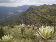
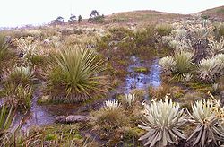
Páramo’s are divided into separate zones based on altitude and vegetation structure, with the three main types of páramo vegetation unequally distributed throughout the different zones.Superpáramo is at the highest elevation and is usually considered to be the transition zone between the higher, permanent snow region and the lower grass páramo zone. The superpáramo zone is generally narrow and exists atop loose stones and sandy soils at about 4500-4800 m. It has the lowest air temperature, precipitation level, soil water-holding capacity, and nutrient content of all the zones. Being the highest in altitude, it also has the highest levels of solar radiation and night-frost. For this reason, vegetation in the superpáramo must be highly resistant to such severe fluctuations in weather.1 Air temperatures are low- cold at night and cool during the day with daily oscillations larger than the oscillations of monthly averages. Due to its localization on high mountains, this area is the least disturbed by humans and contains the most endemic species of all the zones.This paramo often has so much visible sand that it’s easily mistaken for a beach or desert, however there are many tiny, clumped or scattered plants that persist in this zone. Some examples include Azorella pedunculat from the Apiaceae
Apiaceae
The Apiaceae , commonly known as carrot or parsley family, is a group of mostly aromatic plants with hollow stems. The family is large, with more than 3,700 species spread across 434 genera, it is the sixteenth largest family of flowering plants...
family, as well as plants from the Asteraceae
Asteraceae
The Asteraceae or Compositae , is an exceedingly large and widespread family of vascular plants. The group has more than 22,750 currently accepted species, spread across 1620 genera and 12 subfamilies...
, Fabaceae
Fabaceae
The Fabaceae or Leguminosae, commonly known as the legume, pea, or bean family, is a large and economically important family of flowering plants. The group is the third largest land plant family, behind only the Orchidaceae and Asteraceae, with 730 genera and over 19,400 species...
, and Ericaceae
Ericaceae
The Ericaceae, commonly known as the heath or heather family, is a group of mostly calcifuge flowering plants. The family is large, with roughly 4000 species spread across 126 genera, making it the 14th most speciose family of flowering plants...
families.
The most broadly described zone is that of the grass páramo. Grass páramos cover large areas of mountain ranges, while others are limited to small areas on slopes and summits of very high mountains. This is often what people are referring to when they use the term “páramo.” It has continuous vegetation and plant cover with a “yellowish to olive – brown” look due to the combination of dead grasses amongst the living. The grass páramo exists from approximately 3500 - 4100 m, and is composed of mostly tussock-grasses or bunch-grasses. Plant species of the Calamagrostis and Festuca genera’s tend to dominate this zone. Other common vegetation includes large and small shrubs, stunted trees, cushion plants, herbs, graminoids, and rosette plants. While these are the dominant species, grass páramo’s can also contain tall- and short-grass communities, including herbaceous and woody vegetation. Due to its easier access and high levels of grass, this zone is more impacted by humans and suffers from both burning and grazing activities.
Subpáramo is the lowest and most diverse zone. At 3000 – 3500 m, it is a shrub-dominated zone that combines aspects of both the grass páramo above and the forest below. Along with shrubs, this zone also contains small, scattered trees which gradually transition into the grasses and herbs of the grass páramo above. Plant communities in this vegetation zone are also known to include thickets that are mainly composed of shrubby or woody vegetation, including species from the Ilex, Ageratina, and Baccharis genera’s. Fragmented forests can appear in the subpáramo due to microclimatic or edaphic conditions, yet the more abrupt changes are generally due to anthropogenic disruption such as cutting, burning, and grazing activityes. Because of these high levels of disruption, it is believed that subpáramos are made up of largely secondary-growth communities. The high levels of disruption also make this zone particularly difficult to define, as humans typically extend and expand the zone for their own purposes, sometimes over hundreds or thousands of years. This has altered forest lines, often lowering them by several hundred meters, which has also affected the zoning habitats for many animals.
Fauna
The vegetation of the paramo provides shelter and habitat for a variety of mammals, birds, insects, amphibians, and reptiles. Some animals commonly found in paramo ecosystems, include the Andean Fox (also referred to as the “Paramo Wolf”, the White-Tailed DeerWhite-tailed Deer
The white-tailed deer , also known as the Virginia deer or simply as the whitetail, is a medium-sized deer native to the United States , Canada, Mexico, Central America, and South America as far south as Peru...
, and the Spectacled Bear
Spectacled Bear
The spectacled bear , also known as the Andean bear and locally as ukuko, jukumari or ucumari, is the last remaining short-faced bear and the closest living relative to the Florida spectacled bear and short-faced bears of the Middle Pleistocene to Late Pleistocene age.The spectacled bear is a...
which occasionaly forages in the high paramo for its favorite snack, Puya bromeliads. Invertebrates such as grasshoppers, cockroaches, beetles, and flies are found mostly in the subparamo. Amphibians have been well documented in paramo ecosystems, including the salamander (Bolitoglossa spp.), and the frog (Eleutherodactylus spp.). Reptiles commonly sighted include lizards and chameleons (Stenocercus spp,. Phenacosaurus spp., and Proctoporus spp.)
In all, 69 species of birds are listed as “total users” of paramo habitats, with “41 species making it their primary habitat and 16 as indicator species”. The Condor
Condor
Condor is the name for two species of New World vultures, each in a monotypic genus. They are the largest flying land birds in the Western Hemisphere.They are:* The Andean Condor which inhabits the Andean mountains....
, also called “King of the Andes” is one of the most impressive and sought-after birds in the Andes, due to its wide wingspan and majestic flight. The most numerous bird families in the paramo, however, include “ the hummingbirds, funariids, finches and flycatchers” who tolerate the cold climate by participating in “a kind of nightly vegetation.” . Other commonly sighted birds include the turkey buzzard (Cathartes aura), eagle, hawk, and falcon (Phalcoboenus carunculatus), and the rufous-fronted parakeet (Bolborhynchus ferrugineifrons).
Hummingbirds, bees and flies are all important pollinators in the paramo, while birds and smaller mammals such as rabbits and guinea pigs are important seed dispersers. Many of the larger mammals of the paramo are difficult to come by as their numbers have continuously dwindled due to being hunted excessively by man.
Human Impact and Climate Change
Humans have inhabited the páramo of the Andes for approximately the past 15,000 years. Deforestation has been extensive and in some cases, like the northern Andes, 90-95% of forests have been cleared. Other sites in Venezuela and Colombia show evidence that humans settled there at least 500-800 years ago and used the land for agriculture and hunting.When Europeans came to the America’s they introduced exotic plants and animals that greatly affected the land, especially the cattle which were introduced to the páramo’s in the early 18th century. By the 20th century, the growing population of settlers led to an increased demand for land, and paramo ecosystems suffered accordingly. As more land was needed for cattle, fire became a very popular resource for clearing land and eventually páramo’s became excessively burned and overgrazed.Both burning and grazing have had a significant impact on the vegetation, soils, species diversity, and water storage capacity of the paramo’s. In burned and disturbed sites that were studied in the Andes, the pH and phosphorous concentration in the soil is higher than in non-burned sites.
Growing populations in Colombia, Venezuela, and Ecuador have forced settlements in higher elevations covering more páramo. Recent developments such as construction of aqueducts, drainage systems, and roads, mining, and afforestaion have been a huge additional páramo disturbance.
Climate change
Climate change
Climate change is a significant and lasting change in the statistical distribution of weather patterns over periods ranging from decades to millions of years. It may be a change in average weather conditions or the distribution of events around that average...
is becoming an increasingly pressing issue for páramo ecosystems. Increases in temperature extremes are forcing many fauna and flora species to higher grounds, and eventually they could face extinction. The Flora of páramo’s are adapted to specific conditions and are thus vulnerable to even small climatic change. Climate change in the Andes is also causing glaciers in the páramo to disappear as well as decreasing rainfall, virtually drying up páramo and in turn, drying up the water supply for cities such as Quito, Ecuador and Bogotá, Columbia.